It looks like you're using an Ad Blocker.
Please white-list or disable AboveTopSecret.com in your ad-blocking tool.
Thank you.
Some features of ATS will be disabled while you continue to use an ad-blocker.

* SEVERE WEATHER ALERT* - Damaging Winds; Large Hail & Tornadoes; Likely Today in the Midwest
page: 2share:
originally posted by: rickymouse
Wouldn't that area be the Mid East or are those two words now bad words in the American Vocabulary? I would think that Midwest would be in the west half of the country.
No...the name was applied back when only the area east of the Mississippi was settled, and even then, not settled overwhelmingly. So, it was the "West" to everyone.
But I get your point...maybe it should just be called the Mid.
a reply to: rickymouse
Imagine how confusing that is for those of us outside of the US...it looks like the US uses their own unique directional system.
Imagine how confusing that is for those of us outside of the US...it looks like the US uses their own unique directional system.
a reply to: snowspirit
The US didn't start out looking the way it does today. West of the Mississippi was no man's land or belonged to other countries...6 flags over Texas.
I don't imagine European countries consider neighboring countries when applying directional names within their own borders. We simply grew a whole lot bigger over time and the old labels stuck.
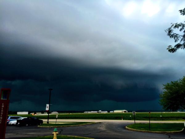
Sitting in the crosshairs today.
Outside it feels like that first 15 minutes in a disaster movie just before SHTF
Stay safe people. As Ron White says, it's not THAT the wind is blowing, it's WHAT the wind is blowing. Hold the Volvos please!
Peace
Outside it feels like that first 15 minutes in a disaster movie just before SHTF
Stay safe people. As Ron White says, it's not THAT the wind is blowing, it's WHAT the wind is blowing. Hold the Volvos please!
Peace
edit on 13-7-2015 by DancedWithWolves because: (no reason given)
As always, thanks to everyone for their contributions and reports!
It's shaping up to be an interesting afternoon - and a very active one in terms of severe weather!
____________
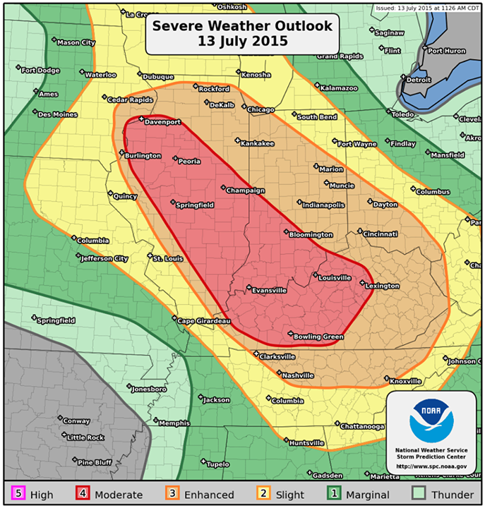
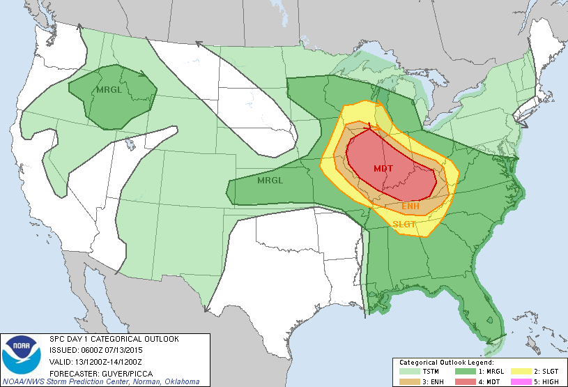
Here is the Latest PWO issued by the NWS-SPC:
It's shaping up to be an interesting afternoon - and a very active one in terms of severe weather!
____________
Here is the Latest PWO issued by the NWS-SPC:
www.spc.noaa.gov...
The main risk for widespread damaging winds, large hail, and a couple of tornadoes are expected in the red/orange shading across Illinois, Indiana, Kentucky, and far eastern Iowa into parts of Ohio and Tennessee. Multiple rounds of storms will generally move southeastward across the region through tonight.
* LOCATIONS...
Illinois
Kentucky
Southern Indiana
Eastern Iowa
* HAZARDS...
Widespread damaging winds, some hurricane force
A few intense tornadoes
Scattered large hail, some baseball size
* SUMMARY...
Multiple rounds of severe thunderstorms capable of damaging
winds, tornadoes and large hail are likely today and tonight
across much of the Midwest, but especially across portions of
Illinois, Indiana, and Kentucky.
a reply to: rickymouse
Really? Turing a weather thread into what we should call the area?
It's the mid west, get over it.
Any know if this storm is going to go west?
Really? Turing a weather thread into what we should call the area?
It's the mid west, get over it.
Any know if this storm is going to go west?
Ominous Looking Storm moving into Columbus, IN:
twitter.com
ALSO:
A Tornado warning has been issued for Jennings County, Ind., until 1:45 pm ET www.weather.com...
twitter.com
ALSO:
A Tornado warning has been issued for Jennings County, Ind., until 1:45 pm ET www.weather.com...
At about 12:45 pm the sun was blotted from the sky. Seriously it was so dark it looked like it was about 10:00 pm. Lots of thunder and heavy wind/rain
but is seems to be over for now. The local news says it will clear up, heart up and give us a second round this evening.
Made it! We will rebuild!
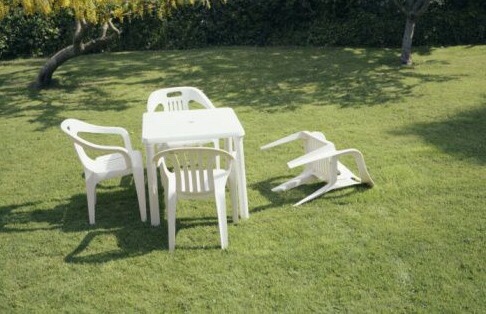
Seriously though, hope everyone is OK and the storms don't kick back up this afternoon severely.
Seriously though, hope everyone is OK and the storms don't kick back up this afternoon severely.
When looking at the radar that area since this morning, I've been seeing a line of heavy thunderstorms moving from North to South which seems out of
the norm for me. Usually, those kinds of storms move from West to East.
Southern Wisconsin/Illinois border here. We had some storms roll through a bit after 5 AM. No big deal, but enough thunder to make the dogs unhappy.
The skies were clear and sunny afterward. Right now, it's 90 F, humid, and the heat index is 101 F. The radar is clear for the time being, but we've
got a severe thunderstorm watch in effect until 9 PM. Guess I'll be keeping an eye on the Weather Channel when I get home from work tonight.
originally posted by: Junkheap
When looking at the radar that area since this morning, I've been seeing a line of heavy thunderstorms moving from North to South which seems out of the norm for me. Usually, those kinds of storms move from West to East.
Where I'm at, the big ones in July usually form up over Western Nebraska during the afternoon and roll out over to Eastern Nebraska before taking a Southeastern turn overnight to dive down along the river toward us. If the conditions are right, they'll roll all night long and nail us. But they definitely will move north to south out where I'm at as a consequence of the river.
Here we go, Everybody!
A Tornado Watch has been issued until 11 pm CDT for parts of central and northern IL, eastern IA and western IN.
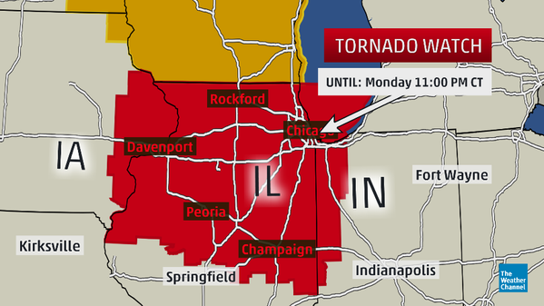
The Atmosphere is Extremely Unstable, and these storms are expected to develop rapidly as the evening progresses.
If you wish to follow these storms visually -
I recommend tvnweather.com... (LIVE STORM CHASING VIDEO)
___
Things are really starting to ramp up - so make sure to stay up to date if you are in the affected areas!
A Tornado Watch has been issued until 11 pm CDT for parts of central and northern IL, eastern IA and western IN.
The Atmosphere is Extremely Unstable, and these storms are expected to develop rapidly as the evening progresses.
If you wish to follow these storms visually -
I recommend tvnweather.com... (LIVE STORM CHASING VIDEO)
___
Things are really starting to ramp up - so make sure to stay up to date if you are in the affected areas!
edit on 13-7-2015 by iunlimited491 because: (no reason given)
South Central WI checking in. The sky to the north turned black in a matter of minutes, and we got some rain. That was it. The BIG event was the
lighting show to the south of us in Northern Illinois. I've never seen so much lightning before-flash, flash, flash after flash but no thunder.
Hubby and I went outside to watch and I have video in MOV format from my camera. Is there a way to upload the file? If there is, please let me know
and I'll upload it.
originally posted by: iunlimited491
Damaging Winds; Large Hail & Tornadoes; Likely Today in the Midwest
Good Morning, ATS.
I thought I'd post this real quick - considering the potential for an extremely dangerous weather scenario, that is currently unfolding in the Midwest...
- and it's always good to be prepared, and to stay informed!
Jul 13, 2015 - Day 1 Convective Outlook
www.spc.noaa.gov...
...SUMMARY...
MULTIPLE ROUNDS OF SEVERE THUNDERSTORMS CAPABLE OF DAMAGING WINDS... TORNADOES AND LARGE HAIL ARE LIKELY TODAY AND TONIGHT ACROSS MUCH OF THE MIDWEST... BUT ESPECIALLY ACROSS PORTIONS OF ILLINOIS... INDIANA... KENTUCKY AND SOUTHWEST OHIO.
www.spc.noaa.gov...
__________
This is a developing situation - so any updates and/or changes to the forecast will be made accordingly.
Tornadoes, Derechoes Possible Monday; Serious Severe Weather Outbreak Likely (FORECAST)www.weather.com...
Broiling heat, extreme humidity fueled by a maturing corn crop, and an unusually strong jet stream by July standards will all combine to bring a potentially major severe weather outbreak, including tornadoes and swaths of widespread wind damage, across a large part of the Midwest, Ohio Valley and Mid-South on Monday. Additional severe weather will spread south and east Tuesday into areas usually well into the summer doldrums by now.
__________
More Information can be found at the links provided^
If you live in these areas, please remember to monitor your local news stations - and keep watch for any alerts or warnings in your area!
All the Best & Be Safe!
I'm not in the danger zone, but I learned something new today. That our vast corn crops can affect humidity in substantial ways. So I did some research and found this:
Corn and climate: a sweaty topic
originally posted by: DancedWithWolves
Made it! We will rebuild!
Seriously though, hope everyone is OK and the storms don't kick back up this afternoon severely.
Thank you for that. I laughed so hard that I think my neighbors heard me.
Looks like I am gonna be toast.
Smack dab in the middle of the red zone.
If yall Don't hear from me tomorrow.
Bye it's been real.
Smack dab in the middle of the red zone.
If yall Don't hear from me tomorrow.
Bye it's been real.
a reply to: iunlimited491
Just starting here in metro Detroit, already I can see transformers lighting the the sky up from lightning strikes. Power has been flickering. Sounds like some powerfull storms coming towards us.
Just starting here in metro Detroit, already I can see transformers lighting the the sky up from lightning strikes. Power has been flickering. Sounds like some powerfull storms coming towards us.
WHAS in Louisville, KY went from their regular programming to all weather alerts about an hour or so ago. They were facing some storms that were
gaining rotation, looking a whole lot like tornadoes forming.
Stay safe out there folks.
We've jumped from normal hot July to extremely humid August weather in western Kentucky this week. The heat index today was 102 F. when the guys came to mow my yard. Felt so bad for them that I made them a big pitcher of fresh-squeezed lemonade. This old lady stayed indoors under the A/C except for a brief trip to the garden for tomatoes, onions and greens!
On the regional designation issue---I'm always amused when traveling in the western states having Kentucky referred to as "out east." I first encountered it in South Dakota when folks asked where I lived. The usual comment was something along the lines of: I don't get out east much but I hear Kentucky is a pretty place.
In Connecticut the response was: Wow! Kentucky! I've never been out west but I'd like to see those horses in the Kentucky Derby.
Yeah, my accent draws attention in those places. Foreigners always guess South Carolina for some reason.
edit on 14-7-2015 by diggindirt
because: spelling
a reply to: iunlimited491
We had a downpour last night. At the height of the rain, I looked out my front door and could not see my truck in the driveway, even though it's only 12 - 15 feet away. Wind broke branches and downed trees all over town and we lost power for about 2 -3 minutes. At 2 AM, I went to check on my daughter, because she wasn't answering her phone and the streets were flooded deeper than I've ever seen them. I had to detour around several streets and areas of town because of whole trees or tree limbs in the road and standing water, up to the bumper of my truck, in some places. City crews are all over this morning, cleaning up the mess.
We had a downpour last night. At the height of the rain, I looked out my front door and could not see my truck in the driveway, even though it's only 12 - 15 feet away. Wind broke branches and downed trees all over town and we lost power for about 2 -3 minutes. At 2 AM, I went to check on my daughter, because she wasn't answering her phone and the streets were flooded deeper than I've ever seen them. I had to detour around several streets and areas of town because of whole trees or tree limbs in the road and standing water, up to the bumper of my truck, in some places. City crews are all over this morning, cleaning up the mess.
new topics
-
President BIDEN's FBI Raided Donald Trump's Florida Home for OBAMA-NORTH KOREA Documents.
Political Conspiracies: 4 hours ago -
Maestro Benedetto
Literature: 5 hours ago -
Is AI Better Than the Hollywood Elite?
Movies: 6 hours ago -
Las Vegas UFO Spotting Teen Traumatized by Demon Creature in Backyard
Aliens and UFOs: 9 hours ago -
2024 Pigeon Forge Rod Run - On the Strip (Video made for you)
Automotive Discussion: 10 hours ago -
Gaza Terrorists Attack US Humanitarian Pier During Construction
Middle East Issues: 10 hours ago -
The functionality of boldening and italics is clunky and no post char limit warning?
ATS Freshman's Forum: 11 hours ago
top topics
-
President BIDEN's FBI Raided Donald Trump's Florida Home for OBAMA-NORTH KOREA Documents.
Political Conspiracies: 4 hours ago, 26 flags -
Krystalnacht on today's most elite Universities?
Social Issues and Civil Unrest: 15 hours ago, 9 flags -
Supreme Court Oral Arguments 4.25.2024 - Are PRESIDENTS IMMUNE From Later Being Prosecuted.
Above Politics: 15 hours ago, 8 flags -
Weinstein's conviction overturned
Mainstream News: 14 hours ago, 8 flags -
Massachusetts Drag Queen Leads Young Kids in Free Palestine Chant
Social Issues and Civil Unrest: 12 hours ago, 7 flags -
Gaza Terrorists Attack US Humanitarian Pier During Construction
Middle East Issues: 10 hours ago, 7 flags -
Las Vegas UFO Spotting Teen Traumatized by Demon Creature in Backyard
Aliens and UFOs: 9 hours ago, 6 flags -
Meadows, Giuliani Among 11 Indicted in Arizona in Latest 2020 Election Subversion Case
Mainstream News: 12 hours ago, 5 flags -
2024 Pigeon Forge Rod Run - On the Strip (Video made for you)
Automotive Discussion: 10 hours ago, 4 flags -
Is AI Better Than the Hollywood Elite?
Movies: 6 hours ago, 3 flags
active topics
-
Supreme Court Oral Arguments 4.25.2024 - Are PRESIDENTS IMMUNE From Later Being Prosecuted.
Above Politics • 89 • : WeMustCare -
SHORT STORY WRITERS CONTEST -- April 2024 -- TIME -- TIME2024
Short Stories • 23 • : DontTreadOnMe -
President BIDEN's FBI Raided Donald Trump's Florida Home for OBAMA-NORTH KOREA Documents.
Political Conspiracies • 16 • : Astyanax -
Truth Social goes public, be careful not to lose your money
Mainstream News • 130 • : Astyanax -
Las Vegas UFO Spotting Teen Traumatized by Demon Creature in Backyard
Aliens and UFOs • 11 • : AwakeNotWoke -
Is AI Better Than the Hollywood Elite?
Movies • 13 • : Justoneman -
Hate makes for strange bedfellows
US Political Madness • 47 • : 19Bones79 -
-@TH3WH17ERABB17- -Q- ---TIME TO SHOW THE WORLD--- -Part- --44--
Dissecting Disinformation • 689 • : daskakik -
University of Texas Instantly Shuts Down Anti Israel Protests
Education and Media • 265 • : Astrocometus -
Gaza Terrorists Attack US Humanitarian Pier During Construction
Middle East Issues • 27 • : ToneD