It looks like you're using an Ad Blocker.
Please white-list or disable AboveTopSecret.com in your ad-blocking tool.
Thank you.
Some features of ATS will be disabled while you continue to use an ad-blocker.

Mars/MRO: The Hellas Planitia "Airstrip" Anomaly
page: 1share:
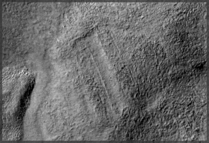
Well, it's not really airstrips, I guess, but that was - in fact - the best analogy I could come up with to describe 3 nearly rectangular
"strips" that caught my attention while checking satellite imagery acquired by the Mars Reconnaissance Orbiter (MRO). The interesting thing about
these 'strips' is that they are all ~1000m across (lengthwise). Coincidence? You be the judge ...
All of the below formations are located within a range of 25 kilometers in a region called 'Hellas Planitia'. The images are grey-scale and were taken using the HiRISE Context Camera (CTX) with a resolution of ~5m/pixel. Here goes a map with all 3 formations in one overview (MRO CTX Source Image):
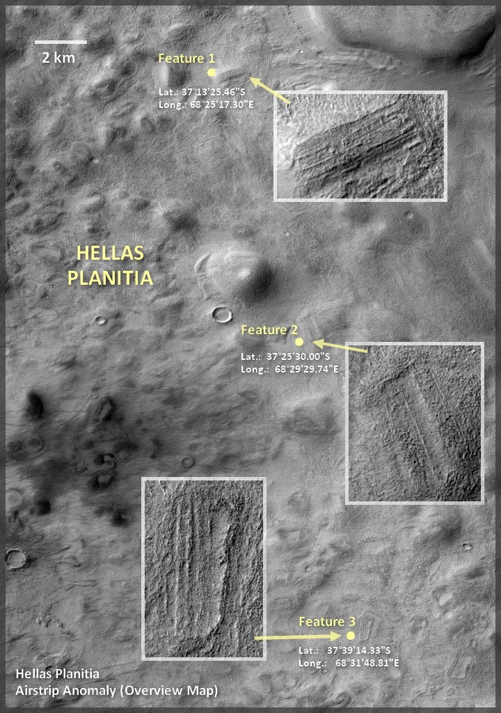
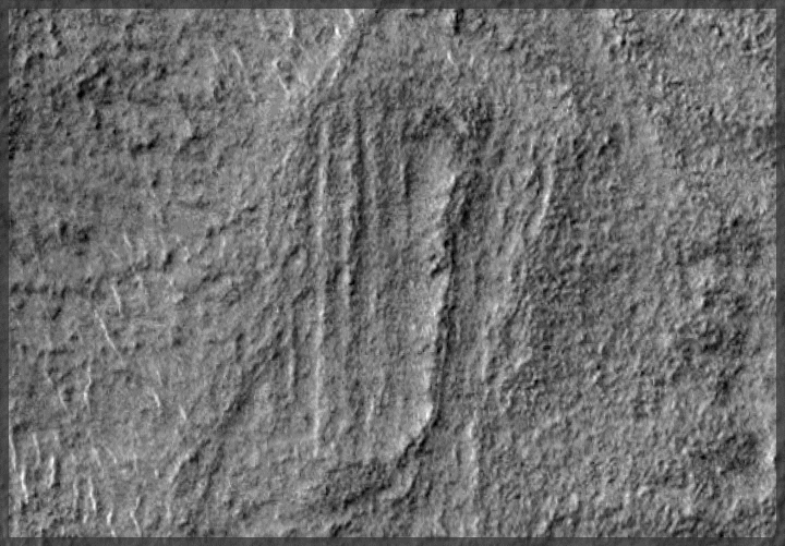
Enlarged close-up views of the 3 formations referenced above:
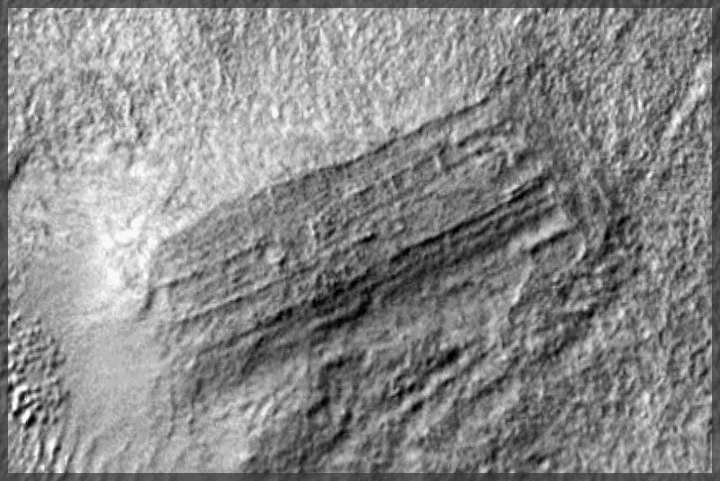

The first formation is probably the most noteworthy, mostly due to the various subdivisions which seem to be logical proportions of the base dimensions, eg. 100m (1/10th of 1km), 50m (1/20th of 1km) and so on. In order to illustrate these relations, here goes a more detailed close-up:
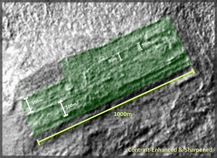
The fact that all of the above formations have roughly the same length incl. similar straight features over a distance of one kilometer made me think it might be worth posting this. That's not to say that these are necessarily artificial structures, but even in geological terms this could be of interest given these extraordinary alignments and subdivisions. Should anybody happen to know similar formations on Earth displaying such patterns, I'd be grateful for any additional information and/or comparisons.
Thanks for reading up to here and I'm very much looking forward to your thoughts on this ...
Sources & Links:
---------------------------
1. MRO CTX Source Image (Image ID: P17_007741_1406_XI_39S291W)
2. Hellas Planitia (Wikipedia)
3. Overview Map of Hellas Planitia
All of the below formations are located within a range of 25 kilometers in a region called 'Hellas Planitia'. The images are grey-scale and were taken using the HiRISE Context Camera (CTX) with a resolution of ~5m/pixel. Here goes a map with all 3 formations in one overview (MRO CTX Source Image):
Enlarged close-up views of the 3 formations referenced above:
The first formation is probably the most noteworthy, mostly due to the various subdivisions which seem to be logical proportions of the base dimensions, eg. 100m (1/10th of 1km), 50m (1/20th of 1km) and so on. In order to illustrate these relations, here goes a more detailed close-up:
The fact that all of the above formations have roughly the same length incl. similar straight features over a distance of one kilometer made me think it might be worth posting this. That's not to say that these are necessarily artificial structures, but even in geological terms this could be of interest given these extraordinary alignments and subdivisions. Should anybody happen to know similar formations on Earth displaying such patterns, I'd be grateful for any additional information and/or comparisons.
Thanks for reading up to here and I'm very much looking forward to your thoughts on this ...
Sources & Links:
---------------------------
1. MRO CTX Source Image (Image ID: P17_007741_1406_XI_39S291W)
2. Hellas Planitia (Wikipedia)
3. Overview Map of Hellas Planitia
edit on 16-2-2014 by jeep3r because:
text
reply to post by jeep3r
I want to be your advocate but I just don't see it. These could be airstrips but doubtful.
I want to be your advocate but I just don't see it. These could be airstrips but doubtful.
lostbook
reply to post by jeep3r
I want to be your advocate but I just don't see it. These could be airstrips but doubtful.
The term 'airstrip' was solely an analogy I used to describe the straight & rectangular features, reminded me of the layout of airstrips. So I'm not saying that's what it is, but I think the amount of 3 such formations with similar straight line geometry and almost equal lengths is somewhat peculiar.
Thanks for your opinion, though, wish I could make you see it even more!
reply to post by jeep3r
NO.
Beware, my friend, you are entering in a strange dominion.... Hell (as) Basin
S&F.
The interesting thing about these 'strips' is that they are all ~1000m across (lengthwise). Coincidence?
NO.
Beware, my friend, you are entering in a strange dominion.... Hell (as) Basin
S&F.
edit on 16-2-2014 by Arken because: (no reason given)
I think you missed one (whatever it may be) in the lower right corner.
Arken
Beware, my friend, you are entering in a strange dominion.... Hell (as) Basin
Hellas means Greece.
reply to post by jeep3r
Fantastic find and I will have to do some thinking on these, but they are not alligned with one another so that would seem to rule out rock strate which is the argument the skeptical are most likely to make, there uniform dimension is peculiar, You have seen the video which seem's to show Highway's as the youtube poster called them well I actually watched on several year's ago almost identical but in higher definition that I can not now find on the net, it seemed to show a line like a central reserve or land divider running along it's center, the erosion on that terrain seemed to show a massive amount of water had at some point swept over it destroying it and the road while recessed in places seemed to have survived in a broken line running in a fashion not conducive with the terrain, Could these be similar in that the terrain has eroded at a faster rate but they had somehow survived, one remind's me of lowel's canali with a deep rill that could have conveyed water but the fact it is only one kilometer long, or could that merely be hardened concrete or stone section's and the other part's may have been simple altered terrain which has worn away under erosion over time.
Oh here is that you tube video but I know you have seen it already and the skeptics say (Wrongly) it is were the image was mapped together but that does not account for the fact the erosion in the terran that crosses this structure is not also lined by that mapping, you can even see were the asphalt surface has been worn away showing it has an under layer in parts were the chasm's that have open up in the terrain under the water erosion have washed out section's of it, this of course mean's it is very ancient indeed and something pretty bad did happen to mars.
I wonder if we came from there.
www.youtube.com...
www.youtube.com...
www.youtube.com...
I believe there was once a heavily industrialized and advanced civilisation in the solar system, I tend to think humans are linked to that lost age and something very catachlysmic happened, now there is the convincing argument by a former NASA scientist that the asteroid belt is all that is left of a planet and mars bore a massive bombardment, he think's mars was in orbit of this other planet and it somehow exploded, the only evidence is one side of mar's is totally devastated and there is an asteroid belt, Skeptics say no way there are not enough asteroid's but they forget angular trajectory and orbital variance which would leave only a tiny fragment of any such planet still in it's original orbit, ie the asteroid belt.
Here is one they described as an image stich but hell they could not come up with an explanation for the shadow at the side of the train like structure on the track's.
www.youtube.com...
edit on 16-2-2014 by LABTECH767 because: (no reason given)
reply to post by jeep3r
If they came from Mars to Pumapunku that would explain why they built at high altitudes, more like home.
Very unnatural looking! Is there anyway to tell the height or depth of these? Clearly some are more eroded than others.
Frustrating no way to check into them further.
I can see why you were thinking airstrip like.
OMG! Wow here is a perfect match!
Is Pumapunku our smoking gun? From ATS
www.abovetopsecret.com...
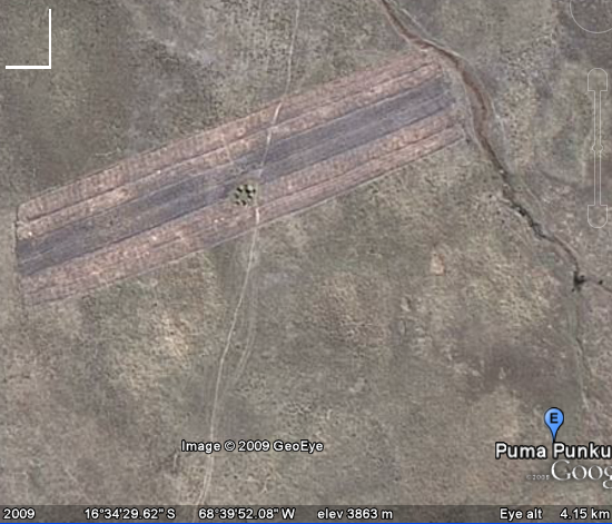
edit on 16-2-2014 by Char-Lee because: (no reason given)
edit on 16-2-2014 by Char-Lee because: (no reason given)
ArMaP
Arken
Beware, my friend, you are entering in a strange dominion.... Hell (as) Basin
Hellas means Greece.
I know Armap, I know, but what lies in Hellas Basin is more closer to an Hell...
I don't know. Honestly, it brings to mind the moving rocks in the desert and the trails they leave.
This occurs when moisture accumulates on the surface of the desert floor and freezes, then the winds pick up tunnel speed velocities between large formations of rocks.
Then it's just like a game of curling. The rocks slide across the desert floor, in this cases mars ground, like they were on ice - because they are. Wind and storms and such will do much to change the landscape of Mars continuously, no?
I know these formations in the Mars ground are massive, and likely don't apply in this case, but it's what came to my mind when I saw them.
CdT
edit on 16-2-2014 by CirqueDeTruth because: (no reason given)
Arken
Beware, my friend, you are entering in a strange dominion.... Hell (as) Basin
S&F.edit on 16-2-2014 by Arken because: (no reason given)
Thanks, Arken, I've been scanning that area for a while now and I've come across a few other interesting formations as well. I'll certainly post those, too, in a few weeks time ... I never stop wondering about the many interesting features that you can stumble across on these MRO/HiRISE images!
wildespace
Very interesting! These might be due to glacial action. en.wikipedia.org...
I was also thinking along the lines of some natural cause, at first ... if it wasn't for some of the geometric details they 'seemingly' have in common.
Whatever the case, any geological explanation is - of course - also appreciated and welcome!

Talking about billions of years erosion here? Then it could be some intelligently made by some civilization.. I don't know I'm neutral about this? But
nevertheless worth discussing..
edit on 0b18America/ChicagoSun, 16 Feb 2014 13:20:18 -0600vAmerica/ChicagoSun, 16 Feb 2014 13:20:18
-06001 by 0bserver1 because: (no reason given)
Char-Lee
reply to post by jeep3r
If they came from Mars to Pumapunku that would explain why they built at high altitudes, more like home.
Very unnatural looking! Is there anyway to tell the height or depth of these? Clearly some are more eroded than others.
Frustrating no way to check into them further.
I can see why you were thinking airstrip like.
OMG! Wow here is a perfect match!
Is Pumapunku our smoking gun? From ATS
www.abovetopsecret.com...
edit on 16-2-2014 by Char-Lee because: (no reason given)edit on 16-2-2014 by Char-Lee because: (no reason given)
www.projectpegasus.net...
Andrew Basiago may heve more info on the Mars issue.
reply to post by jeep3r
In Hellas Basin there is the real "Stairway of Giants"...
But this for another thread.
In Hellas Basin there is the real "Stairway of Giants"...
But this for another thread.
reply to post by Char-Lee
I have to agree with Char Lee there are a number of feint square's inside the upper image, the lower one section has what appear's to be further square foundation's to the lower left of it in the roughly triangular area outside that, indeed I would love to see a high resolution view of this area with sunlight at different angle's,.
No doubt if this was on earth it would already be classified as ancient structure's, this may be the eroded imprint of an ancient city and with careful observation one of the best example's yet.
I think Char lee's comparison is the best so far of both the Nazca platau (which is only linked to the lines because of there presence but is actually a mountain with the top cut clean off to make a rectangular flat area) and the ruin's which though much smaller doese bear a striking resemblance to the top most image which has mutiple right angle's and square enclosures in it.
reply to post by Char-Lee
And in the Mars to Pumu thought train (running the red-eye to Loonytown) maybe the radioactivity found on Mars that only occurs from nuclear explosions (Xenon 130-something) is NOT from a postulated "natural atomic chain reaction" explosion centered near Cydonia but from a planet-of-the-apes scenario (or Battlestar G, etc.) where we nuked ourselves there and moved here.
That would explain our sun and gravity sensitivity, 'cause we're used to Mars' conditions... the ol' we're Martians deal...
But there are a few holes... but it's fun and possible... and sobering.
Char-Lee
reply to post by jeep3r
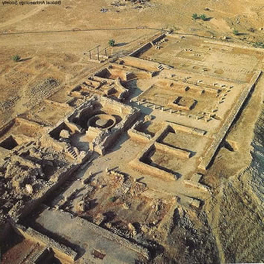
These comparisons are amazing, I wasn't aware of those features located near Puma Punku. I needed some time to check that on Google Earth, but even though they're slightly smaller it seems that there are several of them in close proximity (all of them aligned/oriented differently, similar to the examples in this OP) ... will do some more checking later on!
Do you happen to know where that other pic is from (see above)? I also noticed two circular features incl. one that's a bit like a spiral (in the very first anomaly, feature 1 in the overview), which at first glance looks very similar to those of the ancient site you referenced. Would be neat to check that one more in detail as well.
Thanks again for linking those images ... !
new topics
-
BREAKING: Astrazeneca admits for the first time its vaccine can cause deaths and serious injuries
Medical Issues & Conspiracies: 2 hours ago -
New Bombshell Evidence Strongly Suggests Trump was Set Up in Classified Docs Saga
US Political Madness: 7 hours ago -
One More Night at the Pig and Blanket (Time 2024)
Short Stories: 9 hours ago -
Expert Says Parents Should Ask Babies Permission to Change Nappies.
General Chit Chat: 11 hours ago
top topics
-
New Bombshell Evidence Strongly Suggests Trump was Set Up in Classified Docs Saga
US Political Madness: 7 hours ago, 25 flags -
Say his name
US Political Madness: 17 hours ago, 19 flags -
Jim Biden Was in Business with Qatari Officials
US Political Madness: 15 hours ago, 12 flags -
Expert Says Parents Should Ask Babies Permission to Change Nappies.
General Chit Chat: 11 hours ago, 10 flags -
Sleep paralysis and the implantation of some weird Matrix-esque demon creature...
The Gray Area: 16 hours ago, 8 flags -
I may have had a talk with Pope Francis about his plans for our nation
The Gray Area: 15 hours ago, 6 flags -
One More Night at the Pig and Blanket (Time 2024)
Short Stories: 9 hours ago, 5 flags -
Do you name your cars ?
General Chit Chat: 13 hours ago, 4 flags -
BREAKING: Astrazeneca admits for the first time its vaccine can cause deaths and serious injuries
Medical Issues & Conspiracies: 2 hours ago, 3 flags -
Hard evidence of a Royal plot on the US....if only i had proof.
ATS Skunk Works: 12 hours ago, 2 flags
active topics
-
New Bombshell Evidence Strongly Suggests Trump was Set Up in Classified Docs Saga
US Political Madness • 34 • : 19Bones79 -
Official denial
Diseases and Pandemics • 23 • : annonentity -
New whistleblower Jason Sands speaks on Twitter Spaces last night.
Aliens and UFOs • 77 • : gippo88 -
BREAKING: Astrazeneca admits for the first time its vaccine can cause deaths and serious injuries
Medical Issues & Conspiracies • 1 • : Markovian2 -
Hamas and Other Islamist Terrorist Groups Announce Support of US Campus Anti-Israel Protests
Education and Media • 21 • : Vermilion -
One More Night at the Pig and Blanket (Time 2024)
Short Stories • 3 • : 19Bones79 -
Why Files Our Alien Overlords | How We Secretly Serve The Tall Whites
Aliens and UFOs • 24 • : yuppa -
Definitive 9.11 Pentagon EVIDENCE.
9/11 Conspiracies • 440 • : LaBTop -
Say his name
US Political Madness • 42 • : nugget1 -
It takes One to Be; Two to Tango; Three to Create.
Philosophy and Metaphysics • 9 • : Compendium