It looks like you're using an Ad Blocker.
Please white-list or disable AboveTopSecret.com in your ad-blocking tool.
Thank you.
Some features of ATS will be disabled while you continue to use an ad-blocker.

The Strange Sound Being Heard Around The World Redux: The Menominee Crack Revisited
page: 111
share:
The Strange Sound Being Heard Around The World Redux: The Menominee Crack Revisited
Strange Roaring Noise In Northern Michigan - Light Show Too!
www.abovetopsecret.com...
by OldCorp
started on 1/10/2012 @ 08:51 PM
I don't know if there have been reports of unexplained fissures opening in other areas where the sound has been reported. There may be a connection. There may not be a connection. Just thought I'd mention it for your consideration.
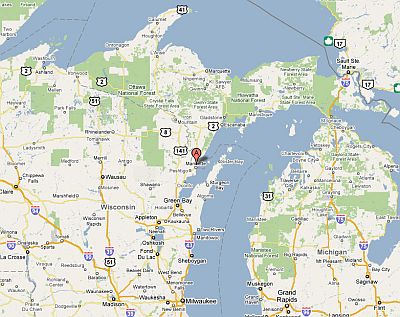
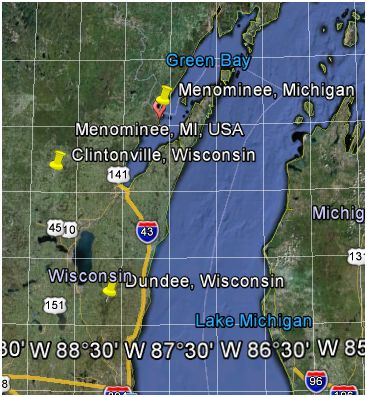
Coordinates:
45°12'48.44"N
87°35'15.57"W
Earth Changes?Unexplained Crevice Appears in Michigan
www.abovetopsecret.com...
Unexplained Crack Splits UP Backyard
www.fox11online.com...
www.freerepublic.com...
The Menominee Crack
www.geo.mtu.edu...
(see article for more)
Location Of Fissure:
Strange Roaring Noise In Northern Michigan - Light Show Too!
www.abovetopsecret.com...
by OldCorp
started on 1/10/2012 @ 08:51 PM
I don't know if there have been reports of unexplained fissures opening in other areas where the sound has been reported. There may be a connection. There may not be a connection. Just thought I'd mention it for your consideration.
Coordinates:
45°12'48.44"N
87°35'15.57"W
Earth Changes?Unexplained Crevice Appears in Michigan
www.abovetopsecret.com...
Originally posted by PatriotsPride
Earth Changes?Unexplained Crevice Appears in Michigan
theintelhub.com
(visit the link for the full news article)
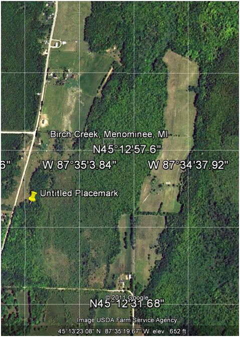
A large crevice,stretching almost two football fields,suddenly appeared in the wood near Birch Creek.
MENOMINEE TOWNSHIP-It's a geological phenomenon that has both authorities and Menominee Township residents scratching their heads.
edit on 7-10-2010 by PatriotsPride because: I misspelled earth
Unexplained Crack Splits UP Backyard
www.fox11online.com...
Unexplained Crack Splits UP Backyard
Updated: Wednesday, 06 Oct 2010, 11:11 AM CDT
Published : Tuesday, 05 Oct 2010, 9:36 PM CDT
BIRCH CREEK, Mich. - A Michigan family's property has a sudden unexplained divide.
A large unexplained crack now runs 200 yards through the Salewsky family's property, eight miles north of Menominee in Birch Creek.
The family thinks it happened yesterday around 9:00 in the morning. The ground raised five feet up, taking trees along for the ride.
Some cracks were up two feet wide and five feet deep.
"The house shook, the chairs shook," Doug Salewsky said. "The logs weren't there when I piled them."
Salewsky doesn't know what caused his backyard to split in two and neither do police.
There have been no recent reports of any earthquakes in the area.
People specializing in geological surveying are being called in to try and explain the phenomenon.
www.fox11online.com...
www.freerepublic.com...
The Menominee Crack
www.geo.mtu.edu...
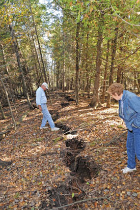
On Monday morning, 04 October 2010, a large noise and shaking were observed in a small area north of the town of Menominee, in Michigan’s Upper Peninsula. The following day, a local resident returned to the site of a fallen tree that was being removed for firewood, and observed a large crack in the ground. This feature was reported to local officials, who contacted Michigan Tech, and the news media.
On Sunday, 09 October, Dr Wayne Pennington, Chair of the Department of Geological and Mining Engineering and Sciences of Michigan Technological University, visited the site (figure 1 and figure 2). The following is a report of observations and tentative conclusions...
www.geo.mtu.edu...
(see article for more)
Location Of Fissure:
edit on 1/11/2012 by this_is_who_we_are because: typos and OldCorp thread link
I have seen cracks like these before, not as long but about the same width. Makes you wonder with all the sounds and movement if the world is about to
do a flip or the earth is expanding.
A number of videos may be found by folowing this
Google Image Search Results Link for the search term Menominee Crack
Here are two chosen at random for your viewing pleasure:
Here are two chosen at random for your viewing pleasure:
This may be of interest as well:
The Niagara Escarpment
Niagara Escarpment
en.wikipedia.org...
The Niagara Escarpment
An escarpment is a steep slope or long cliff that occurs from erosion or faulting and separates two relatively level areas of differing elevations.
Most commonly, an escarpment is a transition from one series of sedimentary rocks to another series of a different age and composition. When sedimentary beds are tilted and exposed to the surface, erosion and weathering may occur differentially based on the composition. Less resistant rocks will erode faster, retreating until the point they are overlain by more resistant rock (see cross section schematic). When the dip of the bedding is gentle, a cuesta is formed. Steeper dips (greater than 30-40°)[2] form hogbacks.
Escarpments are also frequently formed by faults. When a fault displaces the ground surface so that one side is higher than the other, a fault scarp is created. This can occur in dip-slip faults, or when a strike-slip fault brings a piece of high ground adjacent to an area of lower ground.
en.wikipedia.org...
The red half-circle denotes the Niagara Escarpment, a geologically active fault zone. Menominee is just about at 11 o-clock on the half-circle.
www.macombdaily.com...
en.wikipedia.org...:Niagara_Escarpment_map.png
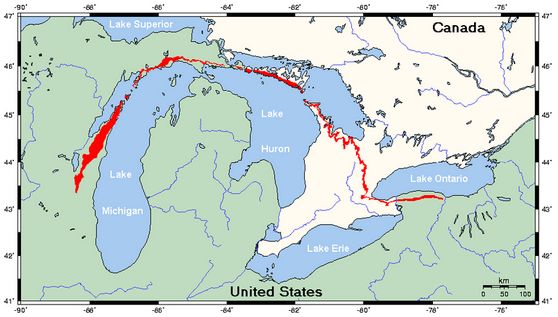
Niagara Escarpment
en.wikipedia.org...
The Niagara Escarpment is a long escarpment, or cuesta, in the United States and Canada that runs westward from New York State, through Ontario, Michigan, Wisconsin and Illinois. It is composed of the Lockport geological formation of Silurian age, and is similar to the Onondaga geological formation, which runs parallel to it and just to the south, through western New York and southern Ontario. The escarpment is most famous as the cliff over which the Niagara River plunges at Niagara Falls, for which it is named.
The Niagara Escarpment is the most prominent of several escarpments formed in the bedrock of the Great Lakes basin. From its easternmost point near Watertown, New York[1], the escarpment shapes in part the individual basins and landforms of Lakes Ontario, Huron and Michigan. In Rochester, New York, there are three waterfalls over the escarpment where the Genesee River flows through the city. The escarpment thence runs westward to the Niagara River forming a deep gorge north of Niagara Falls, which itself cascades over the escarpment. In southern Ontario it spans the Niagara Peninsula, closely following the Lake Ontario shore through the cities of St. Catharines, Hamilton and Dundas, where it takes a sharp turn north in the town of Milton toward Georgian Bay. It then follows the Georgian Bay shore northwestwards to form the spine of the Bruce Peninsula and Manitoulin Island, as well as several smaller islands located in northern Lake Huron where it turns westwards into the Upper Peninsula of northern Michigan, south of Sault Ste. Marie. It then extends southwards into Wisconsin following the Door Peninsula through the Bayshore Blufflands and then more inland from the western coast of Lake Michigan and Milwaukee ending northwest of Chicago near the Wisconsin-Illinois border.
en.wikipedia.org...
edit on 1/11/2012 by this_is_who_we_are because: typos
Some atribute the sound to fracking. Others say it's the sound of cloaked hovering alien craft. I like to think it's cloaked alien craft myself.
Seriously.
But for balance, here are a couple of links on fracking in Michigan.
Fracking In Michigan Appears On The Upswing
www.crainsdetroit.com...#
Originally Published: May 27, 2011 11:25 AM Modified: June 01, 2011 4:01 PM
“Fracking” Gas Companies Target Northern Michigan
glenarborsun.com...
published June 30, 2010
By Eartha Melzer
Sun contributor
This is the only map I could find of Michigan’s current frack wells. I didn't do a thorough search though. In addition, the site does not give a source for their map on their webpage but I tracked it down to:
www.michigan.gov...
banmichiganfracking.org...
But for balance, here are a couple of links on fracking in Michigan.
Fracking In Michigan Appears On The Upswing
www.crainsdetroit.com...#
Originally Published: May 27, 2011 11:25 AM Modified: June 01, 2011 4:01 PM
“Fracking” Gas Companies Target Northern Michigan
glenarborsun.com...
published June 30, 2010
By Eartha Melzer
Sun contributor
As natural gas companies prepare to prospect in northern Michigan, experts are warning landowners to be careful about selling off mineral rights.
When the state took in an all-time record $178 million in a mineral rights auction back in May, it became apparent that natural gas companies see new opportunities in a shale formation that lies like a bowl under much of northwest-lower Michigan.
Up until May gas companies had been offering landowners around $150 per acre for mineral rights, but when bidding against each other for the right to drill on state land, the companies were willing to pay far more — an average of about $1,500 per acre. One parcel in Charlevoix County went for $5,500 per acre.
glenarborsun.com...
This is the only map I could find of Michigan’s current frack wells. I didn't do a thorough search though. In addition, the site does not give a source for their map on their webpage but I tracked it down to:
www.michigan.gov...
banmichiganfracking.org...
edit on 1/11/2012 by this_is_who_we_are because: typo, duplicate
link
There are so many threads on this subject continously coming up that it's getting impossible to keep up. There needs to be a special category for
these now......just a sample of the "sound threads"....just type in strange sound in the search function.
As to your question OP....this is very interesting....I had not heard of it before!
As to your question OP....this is very interesting....I had not heard of it before!
Can anyone add to this thread please- trying to track these things in one place and
build a bigger picture
Cheers
Cheers
reply to post by StealthyKat
Great idea, how about it mods? Can you create a main group in Fragile earth for the fracking issue?
Great idea, how about it mods? Can you create a main group in Fragile earth for the fracking issue?
Bump for the Wisconsin booming debacle. Lest we forget.
edit on 3/23/2012 by this_is_who_we_are because: photo
A new related thread:
Unexplained ground cracks, tear earth in Arizona and Officials investigate cause behind massive earth-split in Brazil
www.abovetopsecret.com...
by sarahlm
started on 3/26/2013 @ 03:51 AM
Unexplained ground cracks, tear earth in Arizona and Officials investigate cause behind massive earth-split in Brazil
www.abovetopsecret.com...
by sarahlm
started on 3/26/2013 @ 03:51 AM
Might this be important as well when taken with the "Unexplained Sounds Being Heard Around The World" angle to the related story out of Arizona?
Unidentified "booms" over Tucson, Arizona USA,
www.abovetopsecret.com...
by Baddogma
started on 2/27/2013 @ 11:34 PM
Unidentified "booms" over Tucson, Arizona USA,
www.abovetopsecret.com...
by Baddogma
started on 2/27/2013 @ 11:34 PM
Initially the geology department at MTU blew it off giving a wrong explanation. When it hit the papers and the net they finally came down there. I
hate when someone with credentials does that initially without even seeing it.
It got explained correctly anyway after a little delay. How many things have been misdiagnosed this way in the past.
This event is a symptom of something that is going to happen along this section. It may not be a real bad event though. There will be more of these cracks happening, some in the woods that will never be seen by us. There are a lot of woods up here and these cracks will be filled in after a few years and just look like grooves in the landscape. Hills disappear as the groundwater goes away. The earth is constantly changing, some so slow that it takes a lifetime and awareness to notice.
I was standing on a hill at my uncles house with my other uncle. He said something is different in the field in back, they used to toboggan down a hill that was there. I looked at him strange. He dug out a childhood picture the next time we were there together and we examined it against the terrain. The hill that was there forty years ago was gone. A big hill at least fifty feet high was now flat. The reservoir was feeding my uncles pond. Now the stream leaving the pond has stopped and the pond level has gone way down. Not many fish can live in it anymore. All within sixty years total. This is a natural event, not a manmade one.
new topics
-
BREAKING: Astrazeneca admits for the first time its vaccine can cause deaths and serious injuries
Medical Issues & Conspiracies: 2 hours ago -
New Bombshell Evidence Strongly Suggests Trump was Set Up in Classified Docs Saga
US Political Madness: 7 hours ago -
One More Night at the Pig and Blanket (Time 2024)
Short Stories: 10 hours ago -
Expert Says Parents Should Ask Babies Permission to Change Nappies.
General Chit Chat: 11 hours ago
top topics
-
New Bombshell Evidence Strongly Suggests Trump was Set Up in Classified Docs Saga
US Political Madness: 7 hours ago, 25 flags -
Say his name
US Political Madness: 17 hours ago, 19 flags -
Jim Biden Was in Business with Qatari Officials
US Political Madness: 15 hours ago, 13 flags -
Expert Says Parents Should Ask Babies Permission to Change Nappies.
General Chit Chat: 11 hours ago, 10 flags -
Sleep paralysis and the implantation of some weird Matrix-esque demon creature...
The Gray Area: 17 hours ago, 8 flags -
I may have had a talk with Pope Francis about his plans for our nation
The Gray Area: 15 hours ago, 6 flags -
One More Night at the Pig and Blanket (Time 2024)
Short Stories: 10 hours ago, 5 flags -
BREAKING: Astrazeneca admits for the first time its vaccine can cause deaths and serious injuries
Medical Issues & Conspiracies: 2 hours ago, 4 flags -
Do you name your cars ?
General Chit Chat: 13 hours ago, 4 flags -
Hard evidence of a Royal plot on the US....if only i had proof.
ATS Skunk Works: 12 hours ago, 2 flags
active topics
-
Candidate TRUMP Now Has Crazy Judge JUAN MERCHAN After Him - The Stormy Daniels Hush-Money Case.
Political Conspiracies • 818 • : WeMustCare -
New Bombshell Evidence Strongly Suggests Trump was Set Up in Classified Docs Saga
US Political Madness • 34 • : 19Bones79 -
Official denial
Diseases and Pandemics • 23 • : annonentity -
New whistleblower Jason Sands speaks on Twitter Spaces last night.
Aliens and UFOs • 77 • : gippo88 -
BREAKING: Astrazeneca admits for the first time its vaccine can cause deaths and serious injuries
Medical Issues & Conspiracies • 1 • : Markovian2 -
Hamas and Other Islamist Terrorist Groups Announce Support of US Campus Anti-Israel Protests
Education and Media • 21 • : Vermilion -
One More Night at the Pig and Blanket (Time 2024)
Short Stories • 3 • : 19Bones79 -
Why Files Our Alien Overlords | How We Secretly Serve The Tall Whites
Aliens and UFOs • 24 • : yuppa -
Definitive 9.11 Pentagon EVIDENCE.
9/11 Conspiracies • 440 • : LaBTop -
Say his name
US Political Madness • 42 • : nugget1
11