It looks like you're using an Ad Blocker.
Please white-list or disable AboveTopSecret.com in your ad-blocking tool.
Thank you.
Some features of ATS will be disabled while you continue to use an ad-blocker.

Mock USSR Airfield in Utah??
page: 10
share:
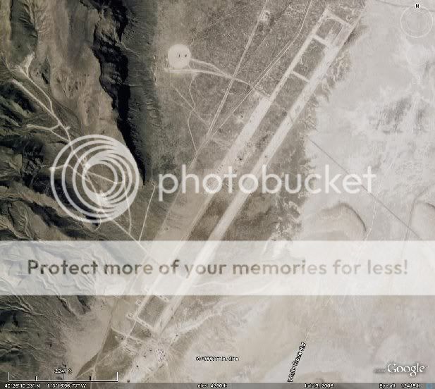
Guys, please fire-up Google Earth and punch in these coordinates. You will see what Im talking about.
Is this something secret?
40"26'19.05 N 113*16'50.28 W
It seems like a military airfield of some sort
Is this something secret?
40"26'19.05 N 113*16'50.28 W
It seems like a military airfield of some sort
What leads you to believe that it emulates an USSR airfield?
Just curious.
Edit to add: If you add a screenshot of the area you're speaking of [thus, eliminating the need to leave ats and launch google earth], more people will probably contribute.
[edit on 10/28/2008 by agent violet]
Just curious.
Edit to add: If you add a screenshot of the area you're speaking of [thus, eliminating the need to leave ats and launch google earth], more people will probably contribute.
[edit on 10/28/2008 by agent violet]
Heres the link and all you have to do is click on were it says View in Google Earth.
bbs.keyhole.com...
I needf to learn in the meantime on how to insert images here...Sorry.
bbs.keyhole.com...
I needf to learn in the meantime on how to insert images here...Sorry.
Nice, thanks.
It's pretty late here but if I get a chance tomorrow I'll insert the image onto the thread, if it hasn't already been done by then.
It's pretty late here but if I get a chance tomorrow I'll insert the image onto the thread, if it hasn't already been done by then.
It's Wendover Air Force Base. I've actually never heard about it, so far a pretty interesting read.
Wiki: Wendover AFB
I'm curious how you came upon it? Random searching?
Wendover Air Force Base is a former United States Air Force base in Utah now known as Wendover Airport. During World War II, it was a training base for B-17 and B-24 bomber crews before being deployed to the European and Pacific Theaters. It was also the training site of the 509th Composite Group, the B-29 unit which dropped the Hiroshima and Nagasaki atomic bombs.
Wiki: Wendover AFB
I'm curious how you came upon it? Random searching?
reply to post by Forest
Actually, no, Wendover is further northwest of the location in question....
The location in question looks run down, and disused, but looks can be deceiving. There are planes parked there, and some of them do kinda look like migs -shrug- i dunno.
Actually, no, Wendover is further northwest of the location in question....
The location in question looks run down, and disused, but looks can be deceiving. There are planes parked there, and some of them do kinda look like migs -shrug- i dunno.
I was just doing research on the Dugway Proving Ground and I had Google Communities enabled in Google Earth and thats how I came across it.
Now, for future pictures of these, how can upload a screenshot in the future here?
Now, for future pictures of these, how can upload a screenshot in the future here?
Originally posted by infocon_delta
Guys, please fire-up Google Earth and punch in these coordinates. You will see what Im talking about.
Is this something secret?
40"26'19.05 N 113*16'50.28 W
It seems like a military airfield of some sort
It's part of Dugway Proving Ground. Just another fake runway with planes, setup for training purposes. They are scattered around Nellis/Tonopah Test Range area as well.
[edit on 28-10-2008 by FosterVS]
Now, for future pictures of these, how can upload a screenshot in the future here?
Originally posted by infocon_delta
Now, for future pictures of these, how can upload a screenshot in the future here?
Numerous ways.
I suggest get a free account on www.photobucket.com
Scale your screenshot to an appropriate size, and upload it to photobucket.
Then click the "Insert an Image" button when you post, and paste in the link to the photobucket image.
new topics
-
A Warning to America: 25 Ways the US is Being Destroyed
New World Order: 2 hours ago -
President BIDEN's FBI Raided Donald Trump's Florida Home for OBAMA-NORTH KOREA Documents.
Political Conspiracies: 7 hours ago -
Maestro Benedetto
Literature: 9 hours ago -
Is AI Better Than the Hollywood Elite?
Movies: 9 hours ago
top topics
-
President BIDEN's FBI Raided Donald Trump's Florida Home for OBAMA-NORTH KOREA Documents.
Political Conspiracies: 7 hours ago, 27 flags -
Weinstein's conviction overturned
Mainstream News: 17 hours ago, 8 flags -
Gaza Terrorists Attack US Humanitarian Pier During Construction
Middle East Issues: 14 hours ago, 8 flags -
Massachusetts Drag Queen Leads Young Kids in Free Palestine Chant
Social Issues and Civil Unrest: 16 hours ago, 7 flags -
Las Vegas UFO Spotting Teen Traumatized by Demon Creature in Backyard
Aliens and UFOs: 13 hours ago, 6 flags -
A Warning to America: 25 Ways the US is Being Destroyed
New World Order: 2 hours ago, 6 flags -
Meadows, Giuliani Among 11 Indicted in Arizona in Latest 2020 Election Subversion Case
Mainstream News: 16 hours ago, 5 flags -
2024 Pigeon Forge Rod Run - On the Strip (Video made for you)
Automotive Discussion: 13 hours ago, 4 flags -
Is AI Better Than the Hollywood Elite?
Movies: 9 hours ago, 3 flags -
The functionality of boldening and italics is clunky and no post char limit warning?
ATS Freshman's Forum: 15 hours ago, 1 flags
active topics
-
Gaza Terrorists Attack US Humanitarian Pier During Construction
Middle East Issues • 32 • : FlyersFan -
-@TH3WH17ERABB17- -Q- ---TIME TO SHOW THE WORLD--- -Part- --44--
Dissecting Disinformation • 690 • : burritocat -
University of Texas Instantly Shuts Down Anti Israel Protests
Education and Media • 266 • : SchrodingersRat -
New whistleblower Jason Sands speaks on Twitter Spaces last night.
Aliens and UFOs • 66 • : baablacksheep1 -
HORRIBLE !! Russian Soldier Drinking Own Urine To Survive In Battle
World War Three • 50 • : F2d5thCavv2 -
Russia Ukraine Update Thread - part 3
World War Three • 5732 • : F2d5thCavv2 -
The Acronym Game .. Pt.3
General Chit Chat • 7751 • : F2d5thCavv2 -
Salvador Dali's Moustaches
People • 28 • : zosimov -
Is AI Better Than the Hollywood Elite?
Movies • 17 • : ThePsycheaux -
The best Rice dish i've ever tasted... Kimchi Rice
Food and Cooking • 26 • : lamhaocc
0