It looks like you're using an Ad Blocker.
Please white-list or disable AboveTopSecret.com in your ad-blocking tool.
Thank you.
Some features of ATS will be disabled while you continue to use an ad-blocker.

Alien City On Mars? Check This Out!
page: 19share:
reply to post by ArMaP
Thank you. I take that as an almost firm "I don't know what the hell it is" answer. Yes, nature does at times make right angles. And at times it may make more than one. It could even make two such things in the same area. And now it has lined them up in such a way that they are perfectly aligned with each other, and forming a very good square.
I think I'll have to stick with "unknown" on this one. I really do respect your input on looking at things with a critical eye. I know you keep a certain detachent from what "can" be seen, and that is the reason I asked your opinion. But do you really think that chance alone could have led to such a formation?
But if the critical asessment, by you and the rest of the scientific community, is as weak as you have put out, then logic alone says there has to be something else at play here. There must be more to the story than such an unlikely chain of events as erosion and volcanic activity creating this anomaly.
But I thank you for the attempt to show this in a natural light.
Greetings from Mars ...
MOC narrow angle image M11-01782

www.msss.com...
MOC wide angle image M11-04182

www.msss.com...
MOC wide angle image M12-02879 ***NEW***

www.msss.com...
MOC narrow angle image M11-01691 ***NEW***

www.msss.com...
MOC narrow angle image M11-03874

www.msss.com...
MOC narrow angle image m10-00058 ***NEW***

www.msss.com...
MOC narrow-angle image M11-02297

www.msss.com...
MOC narrow angle image e1000462

ida.wr.usgs.gov...
MOC wide angle image M12-00729 ***NEW***

www.msss.com...
MOC narrow angle image m00-01661

www.msss.com...
SOl 037 Opportunity

marsrovers.nasa.gov...
MOC narrow angle image AB1-08505

www.msss.com...
Credits:
Malin Space Science System
www.msss.com...
Pegasus Research Consortium
www.thelivingmoon.com...
Anomalias em Marte
anomaliasemmarte.no.sapo.pt...
Mars Unearthed
www.marsunearthed.com...
ATSers
[edit on 11/12/2007 by internos]
MOC narrow angle image M11-01782
www.msss.com...
MOC wide angle image M11-04182
www.msss.com...
MOC wide angle image M12-02879 ***NEW***
www.msss.com...
MOC narrow angle image M11-01691 ***NEW***
www.msss.com...
MOC narrow angle image M11-03874
www.msss.com...
MOC narrow angle image m10-00058 ***NEW***
www.msss.com...
MOC narrow-angle image M11-02297
www.msss.com...
MOC narrow angle image e1000462
ida.wr.usgs.gov...
MOC wide angle image M12-00729 ***NEW***
www.msss.com...
MOC narrow angle image m00-01661
www.msss.com...
SOl 037 Opportunity
marsrovers.nasa.gov...
MOC narrow angle image AB1-08505
www.msss.com...
Credits:
Malin Space Science System
www.msss.com...
Pegasus Research Consortium
www.thelivingmoon.com...
Anomalias em Marte
anomaliasemmarte.no.sapo.pt...
Mars Unearthed
www.marsunearthed.com...
ATSers
[edit on 11/12/2007 by internos]
reply to post by internos
Hey Internos! how are you doing? good finds as usual! What do you make of pic #3? Is that a breach in the ground or a side of a cliff?

Hey Internos! how are you doing? good finds as usual! What do you make of pic #3? Is that a breach in the ground or a side of a cliff?
Internos is really going berserk with those excellent images!!
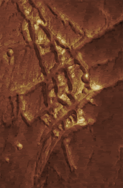
OK, here’s an image of Mars, taken by Mars Express, of Kasei valles (North). I’ve enlarged an area south east of the image that resembles the famous ‘Inca City’ on Mars. And the resemblance is uncanny!
Source ESA
Cheers!
ref:
www.esa.int...
OK, here’s an image of Mars, taken by Mars Express, of Kasei valles (North). I’ve enlarged an area south east of the image that resembles the famous ‘Inca City’ on Mars. And the resemblance is uncanny!
Source ESA
Cheers!
ref:
www.esa.int...
Originally posted by spikedmilk
reply to post by internos
Hey Internos! how are you doing? good finds as usual! What do you make of pic #3? Is that a breach in the ground or a side of a cliff?
Hey my friend!
It looks to be a breach: the lack of perspective doesn't help us, but i assume that the white formation is a relief: it's an unusual formation, at least for what i've seen so far on Mars; but the caption doesn't mention it.
Originally posted by mikesingh
Internos is really going berserk with those excellent images!!
OK, here’s an image of Mars, taken by Mars Express, of Kasei valles (North). I’ve enlarged an area south east of the image that resembles the famous ‘Inca City’ on Mars. And the resemblance is uncanny!
Cheers!
ref:
www.esa.int...
Mike!
Another formation which recalls me Inca City: nice find
[edit on 12/12/2007 by internos]
reply to post by rohnds
I couldnt explain the tracks, but I had to say, that is a very serene picture.
very nice!
[edit on 12-12-2007 by spikedmilk]
I couldnt explain the tracks, but I had to say, that is a very serene picture.
very nice!
[edit on 12-12-2007 by spikedmilk]
reply to post by rohnds
Hey Rohn! Nice pic! Have you got another one of the same area with better res? That would be helpful. Personally I think those 90 deg verticals on the left of the iimage is a photographic glitch. But the 'tracks' going into the crater are pretty interesting!
Cheers!
Hey Rohn! Nice pic! Have you got another one of the same area with better res? That would be helpful. Personally I think those 90 deg verticals on the left of the iimage is a photographic glitch. But the 'tracks' going into the crater are pretty interesting!
Cheers!
Originally posted by mikesingh
reply to post by rohnds
Hey Rohn! Nice pic! Have you got another one of the same area with better res? That would be helpful. Personally I think those 90 deg verticals on the left of the iimage is a photographic glitch. But the 'tracks' going into the crater are pretty interesting!
Cheers!
definite glitch if you follow the 90 degree turn of it across the page goin in a 45 degree you can see the whole of the pic disfigured quite a bit too
cool pic though
its hard to say with different atmospheric pressures and temperatures what exactly can effect soil erosion, debri changes and just land change
so to say any of these are cities is so up for arguement and totally inconclusive on both sides wether opposing or siding with
reply to post by mikesingh
I don't think that it looks like the "Inca city".
The "Inca city" features are high, those features in the ESA image look like common channels and the "Inca city" features have a much more symmetric look than those from the ESA image.
I don't think that it looks like the "Inca city".
The "Inca city" features are high, those features in the ESA image look like common channels and the "Inca city" features have a much more symmetric look than those from the ESA image.
reply to post by mikesingh
That image was posted by Undo on page 14 and 15, and it was discussed for some time, maybe if you look back on your own thread you see if there are any other images with a better resolution of that area.
That image was posted by Undo on page 14 and 15, and it was discussed for some time, maybe if you look back on your own thread you see if there are any other images with a better resolution of that area.
reply to post by rohnds
That looks like the result of the use of the Rover's abrasion tool.
Looking at other photos from the same Sol, like this one, makes me think that it is just that, and area where the abrasion tool was used.
That looks like the result of the use of the Rover's abrasion tool.
Looking at other photos from the same Sol, like this one, makes me think that it is just that, and area where the abrasion tool was used.
Well, i don't think that inca city has simmetries at all
of course is the most interesting one with this type of features, but i've never seen a single simmetry in it (but i could be wrong).
What really has been found interesting in Inca city, are the rectilinear ridges, the intersections between the ridges and the fact that many clues suggest that it's a part of a larger circular complex, and this has been found to be interesting in the year of the discovery, in 1972.
Where for "interesting" is meant that there's more than one possible guess about its origin:
and it has been called so because it vaguely recalled ancient ruins:
but as said the contest was the one of 1972.
[edit on 13/12/2007 by internos]
of course is the most interesting one with this type of features, but i've never seen a single simmetry in it (but i could be wrong).
What really has been found interesting in Inca city, are the rectilinear ridges, the intersections between the ridges and the fact that many clues suggest that it's a part of a larger circular complex, and this has been found to be interesting in the year of the discovery, in 1972.
Where for "interesting" is meant that there's more than one possible guess about its origin:
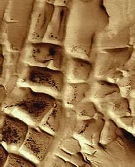
The "Inca City" ridges occur in a topographic low within eroded, layered deposits in the south polar region. The ridges appear to have once been covered by these same layered materials, but were subsequently exhumed by wind erosion. Possible interpretations that have been offered to explain the ridges include the following: (a) ancient sand dunes that became buried by polar ice and dust deposits and were lithified (cemented to make something like sandstone), (b) clastic dikes formed of sand and gravel that infiltrated down into cracks in the polar layered deposits, (c) clastic dikes formed from sand that was squeezed or injected upwards into the polar layered deposits from below, or (d) igneous dikes, composed of solidified magma (molten rock) injected into cracks in the polar layered deposits. In any case, the ridges were exposed to the air as wind scoured away the less-resistant polar layered materials.
and it has been called so because it vaguely recalled ancient ruins:
but as said the contest was the one of 1972.
[edit on 13/12/2007 by internos]
Originally posted by ArMaP
reply to post by mikesingh
I don't think that it looks like the "Inca city".
The "Inca city" features have a much more symmetric look than those from the ESA image.
Well, ArMaP, I beg to differ here! 'More symetrical' you said? I don't think so, and I agree with what internos said. Have a look at this comparison of the 'city' I found and the famous Inca City:
The Inca City.
Courtesy: Burlington News.
The 'city' I found!
Notice the resemblance?
Cheers!
reply to post by mikesingh
Mikesingh, may I ask why you reffer to this lines as an inka city. What makes you sure that this is inka infrastructure?
Mikesingh, may I ask why you reffer to this lines as an inka city. What makes you sure that this is inka infrastructure?
reply to post by tep200377
Tep200377, i hope it's the same if i answer instead of mike (since he's offline now )
www.msss.com...
Tep200377, i hope it's the same if i answer instead of mike (since he's offline now )
"Inca City" is the informal name given by Mariner 9 scientists in 1972 to a set of intersecting, rectilinear ridges that are located among the layered materials of the south polar region of Mars. Their origin has never been understood; most investigators thought they might be sand dunes, either modern dunes or, more likely, dunes that were buried, hardened, then exhumed. Others considered them to be dikes formed by injection of molten rock (magma) or soft sediment into subsurface cracks that subsequently hardened and then were exposed at the surface by wind erosion.
www.msss.com...
reply to post by internos
Thanks internos!
I was just thinking that the inka structure resembles the machu pichu city. but the machu pichu city on earth is a result of the spanis invaders. Some say the city was a built for vacational purposes for the higher ranking inkas, but some say it was made as a safe haven from the spanis invasjon.
My conclusion is that they wouldn't build that kind of infrastructure on flat land. Thats all
Thanks for the link.
[edit on 13-12-2007 by tep200377]
Originally posted by tep200377
reply to post by mikesingh
Mikesingh, may I ask why you reffer to this lines as an inka city. What makes you sure that this is inka infrastructure?
Tep, it's not me who has named it the 'Inca City'! I'm not sure who gave it that name, but it's very commonly known as such. Just Google it and you'll know what I mean!
And as usual, internos has provided the gen in his post above! For some more info check this out....
www.rense.com...
Cheers!
[edit on 13-12-2007 by mikesingh]
Symmetric was a wrong choice of words, but at the time (and even now) it was the best I could find in my mental dictionary.
What I wanted to say is that the picture from ESA shows something that looks like a common channel system, with ramifications, while the "Inca city" features look more like a grid (finally I found the word that I wanted since yesterday) and are a "bas relief" instead of a "haut-relief" like those from the ESA photo.
[edit on 13/12/2007 by ArMaP]
new topics
-
German city in chaos as 'extremist' march sees calls for 'caliphate' and ISIS-style flags
Mainstream News: 1 hours ago -
College protesters want amnesty.
US Political Madness: 3 hours ago -
Shocking moment four men 'try to force Jewish pedestrian into car boot' in North London
Breaking Alternative News: 6 hours ago -
The 'Censorship-Industrial Complex'. It is coming to a nation state near you, any time now...
New World Order: 7 hours ago -
BREAKING: Astrazeneca admits for the first time its vaccine can cause deaths and serious injuries
Medical Issues & Conspiracies: 10 hours ago
top topics
-
New Bombshell Evidence Strongly Suggests Trump was Set Up in Classified Docs Saga
US Political Madness: 16 hours ago, 37 flags -
BREAKING: Astrazeneca admits for the first time its vaccine can cause deaths and serious injuries
Medical Issues & Conspiracies: 10 hours ago, 15 flags -
German city in chaos as 'extremist' march sees calls for 'caliphate' and ISIS-style flags
Mainstream News: 1 hours ago, 13 flags -
Shocking moment four men 'try to force Jewish pedestrian into car boot' in North London
Breaking Alternative News: 6 hours ago, 12 flags -
College protesters want amnesty.
US Political Madness: 3 hours ago, 5 flags -
The 'Censorship-Industrial Complex'. It is coming to a nation state near you, any time now...
New World Order: 7 hours ago, 2 flags
active topics
-
James O’Keefe: I have evidence that exposes the CIA, and it’s on camera.
Whistle Blowers and Leaked Documents • 33 • : SchrodingersRat -
Is AI Better Than the Hollywood Elite?
Movies • 24 • : 5thHead -
Shocking moment four men 'try to force Jewish pedestrian into car boot' in North London
Breaking Alternative News • 39 • : ufoorbhunter -
College protesters want amnesty.
US Political Madness • 17 • : Oldcarpy2 -
German city in chaos as 'extremist' march sees calls for 'caliphate' and ISIS-style flags
Mainstream News • 9 • : Irishhaf -
BREAKING: Astrazeneca admits for the first time its vaccine can cause deaths and serious injuries
Medical Issues & Conspiracies • 10 • : Lochid -
The 'Censorship-Industrial Complex'. It is coming to a nation state near you, any time now...
New World Order • 4 • : Cvastar -
Hurt my hip; should I go see a Doctor
General Chit Chat • 28 • : mysterioustranger -
Do you name your cars ?
General Chit Chat • 17 • : mysterioustranger -
5 probed after 18-year old girl dies as a result of having the COVID jab
Diseases and Pandemics • 22 • : 320MPH