It looks like you're using an Ad Blocker.
Please white-list or disable AboveTopSecret.com in your ad-blocking tool.
Thank you.
Some features of ATS will be disabled while you continue to use an ad-blocker.

Southern Cyclone/Typhoon Watch 2014
page: 1share:
Last year - Southern Cyclone/Typhoon Watch 2012/2013
edit on 01u171714 by muzzy because: (no reason given)
That's the shortest introduction into a thread I've seen, and usually I can figure out where the OP is going but I can't this time. Are you saying
there is a typhoon watch in the Southern Hemisphere? If so what exact location within that hemisphere?
This one whacked Tonga badly, lots of devestation, one person killed
SUBJ: TROPICAL CYCLONE 07P (IAN) WARNING NR 017
WTPS31 PHNC 132100
1. TROPICAL CYCLONE 07P (IAN) WARNING NR 017
01 ACTIVE TROPICAL CYCLONE IN SOUTHPAC
REMARKS:
132100Z POSITION NEAR 31.1S 168.1W.
TROPICAL CYCLONE 07P (IAN), LOCATED APPROXIMATELY 739 NM
SOUTHWESTWARD OF RAROTONGA, HAS TRACKED SOUTHEASTWARD AT 13 KNOTS
OVER THE PAST SIX HOURS.
THIS IS THE FINAL WARNING ON THIS SYSTEM BY THE JOINT TYPHOON
WRNCEN PEARL HARBOR HI. THE SYSTEM WILL BE CLOSELY MONITORED FOR
SIGNS OF REGENERATION. MAXIMUM SIGNIFICANT WAVE HEIGHT AT 131800Z
IS 18 FEET.
Final Track
reply to post by Dianec
I specialize in one line Thread starters, the Mods don't like it, but we get to it going eventually.
I stuffed up the Title anyway, pasted last years Title by mistake.
New TC to follow in a sec.
I specialize in one line Thread starters, the Mods don't like it, but we get to it going eventually.
I stuffed up the Title anyway, pasted last years Title by mistake.
New TC to follow in a sec.
edit on 01u171714 by muzzy because: (no reason given)
The edge of this one should hit Northland and Auckland tomorrow 8-9pm NZST onwards as an ex-TC, whole North Island will get wet Tuesday NZST
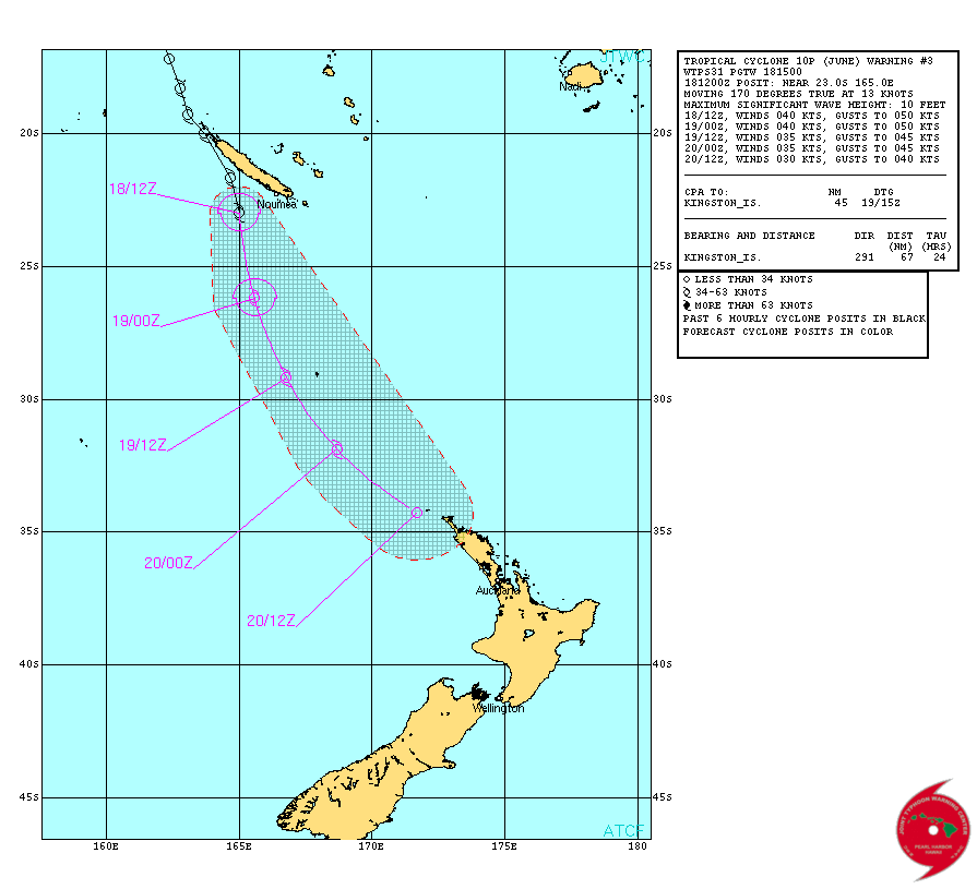
SUBJ: TROPICAL CYCLONE 10P (JUNE) WARNING NR 002
WTPS31 PGTW 180300
1. TROPICAL CYCLONE 10P (JUNE) WARNING NR 002
01 ACTIVE TROPICAL CYCLONE IN SOUTHPAC
REMARKS:
180300Z POSITION NEAR 20.6S 163.9E.
TROPICAL CYCLONE (TC) 10P (JUNE), LOCATED APPROXIMATELY 184 NM
NORTHWEST OF NOUMEA, NEW CALEDONIA, HAS TRACKED SOUTHEASTWARD
AT 09 KNOTS OVER THE PAST SIX HOURS.
link
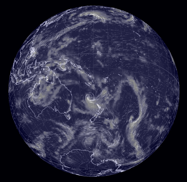
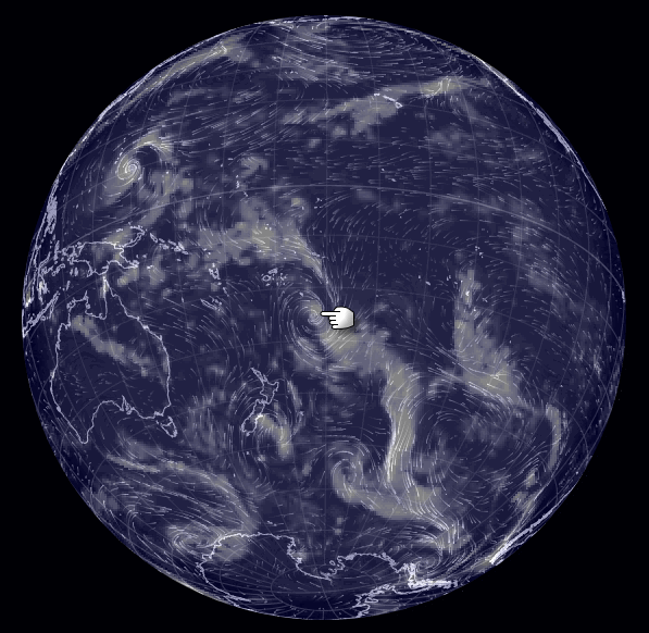
10P.JUNE, TRACK_VIS, 18 JAN 2014 0632Z

Cloud/Wind
a visualization of global weather conditions
forecast by supercomputers
updated every three hours
SW Pacific
(click on the word "earth" for the interactive controls)
Yesterday 18th Jan NZST
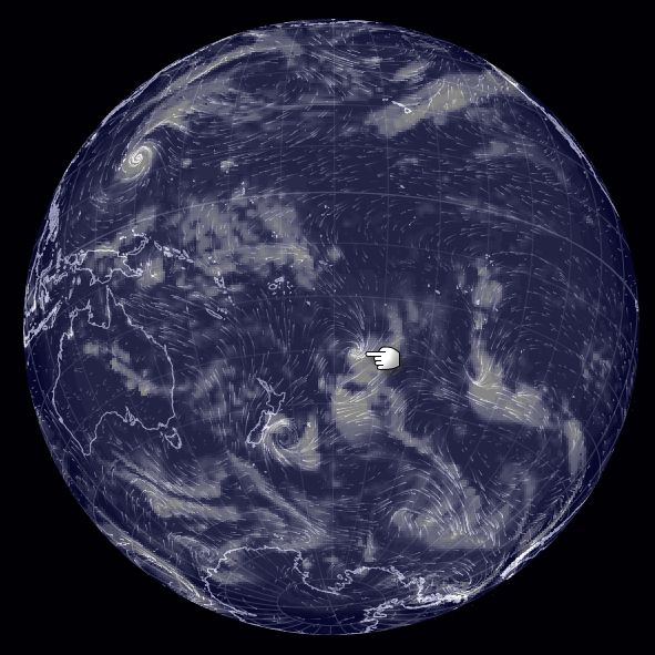
Current 19th Jan NZST
Tommorrow 20th Jan NZST predicted
SUBJ: TROPICAL CYCLONE 10P (JUNE) WARNING NR 002
WTPS31 PGTW 180300
1. TROPICAL CYCLONE 10P (JUNE) WARNING NR 002
01 ACTIVE TROPICAL CYCLONE IN SOUTHPAC
REMARKS:
180300Z POSITION NEAR 20.6S 163.9E.
TROPICAL CYCLONE (TC) 10P (JUNE), LOCATED APPROXIMATELY 184 NM
NORTHWEST OF NOUMEA, NEW CALEDONIA, HAS TRACKED SOUTHEASTWARD
AT 09 KNOTS OVER THE PAST SIX HOURS.
link
10P.JUNE, TRACK_VIS, 18 JAN 2014 0632Z
Cloud/Wind
a visualization of global weather conditions
forecast by supercomputers
updated every three hours
SW Pacific
(click on the word "earth" for the interactive controls)
Yesterday 18th Jan NZST
Current 19th Jan NZST
Tommorrow 20th Jan NZST predicted
edit on 01u171714 by muzzy because: add images
Dianec
That's the shortest introduction into a thread I've seen, and usually I can figure out where the OP is going but I can't this time. Are you saying there is a typhoon watch in the Southern Hemisphere? If so what exact location within that hemisphere?
look at the "members" join date.
enough said.
I am editing because when I read it I sounded rude. in other words...the member does not know about these kinds of threads maybe because of the short time here.
edit on 18-1-2014 by bellagirl because: (no reason given)
181500Z POSITION NEAR 23.8S 165.2E.
TROPICAL CYCLONE 10P (JUNE), LOCATED APPROXIMATELY 81 NM
SOUTHWEST OF NOUMEA, NEW CALEDONIA, HAS TRACKED SOUTHWARD AT
13 KNOTS OVER THE PAST SIX HOURS.
MAXIMUM SIGNIFICANT WAVE HEIGHT AT 181200Z IS 10 FEET. NEXT
WARNINGS AT 190300Z AND 191500Z.
PRESENT WIND DISTRIBUTION:
MAX SUSTAINED WINDS - 040 KT, GUSTS 050 KT
for those not familiar as to how the Navy/NRL Tropical Cyclone Page works, this is the page to go to for fresh updates
www.nrlmry.navy.mil...
not the first link I posted, which was just for that viewing time.
so when you go there you have to click on the TC name on the left column to get the latest text and map page , thenselect text or track from the buttons along the top
latest map (@1500UTC or 4pm NZDT) shows the predicted front has shrunk back from where it was on the first map, so it may be going to peter out quicker.
Another good source for SW Pacific Tropical Cyclone info is the Australian Government Bureau of Meteorology,Queensland
A Cyclone WARNING remains current for Norfolk Island.
EX-TROPICAL CYCLONE JUNE is expected to continue moving in a south southeast
direction over the next couple of days and pass close to the west of Norfolk
Island during the early hours of Monday. The impacts on Norfolk Island are
expected to be similar to a Category 1 tropical cyclone.
The Community and Visitors to Norfolk Island should remain inside until
Ex-Tropical Cyclone June has passed and listen to the next advice at 6:30pm NFT.
- Information is available from Emergency Management Norfolk Island [+6723 999]
or the Norfolk Island Police Force [+6723 22222]
text
map
edit on 01u171714 by muzzy because: (no reason given)
reply to post by bellagirl
bella, it more likely because I don't start a lot of threads.
remember the Quake Watch 2013 fiasco? LOL
3 years is not a long time? seems like forever to me.
I gave you another star, for explaining yourself.
I took it the other way, that having been on ATS for 3 years he knew what he was doing, which I didn't.
edit on 01000000171714 by muzzy
because: (no reason given)
muzzy
reply to post by bellagirl
bella, it more likely because I don't start a lot of threads.
remember the Quake Watch 2013 fiasco? LOL
3 years is not a long time? seems like forever to me.
I gave you another star, for explaining yourself.
I took it the other way, that having been on ATS for 3 years he knew what he was doing, which I didn't.edit on 01000000171714 by muzzy because: (no reason given)
lol you silly ding bat. I was talking about the posters join date. he hasn't been here for 12 months yet. not yours you silly billy.
I was trying to elude to the fact that maybe he hasn't been here long enough to know about the specialized threads such as quake watch, solar watch, this one, volcano watch etc and that every new year a new one starts.
p.s... the quake watch 2013 fiasco was a hoot.
edit on 18-1-2014 by bellagirl because: (no reason given)
I was watching the cyclone tracking south at the moment to look for a possible turn left situation. this is how the east coast lows that hit Sydney
usually start. to me it looks like it will continue in the south/east direction and may give n.z. a bit of a brush.
reply to post by bellagirl
oh well, there goes the New Years Resolution "to be less confused in 2014" (wink)
oh well, there goes the New Years Resolution "to be less confused in 2014" (wink)
Thanks. Muzzy. I didn't mean to come across rude at all so sorry if it sounded like that to you or others. I haven't seen it until now so will just
wait in the future (and I joined the 2013/2014 quake and volcano watch threads which have good intros if you started those). Lots of good info posted
now so will keep an eye on where these storms go. Thanks for keeping us all updated on this.
You Aussies will know about it, but the rest might not. Tropical Cyclone Dylan, Category 1

www.bom.gov.au...

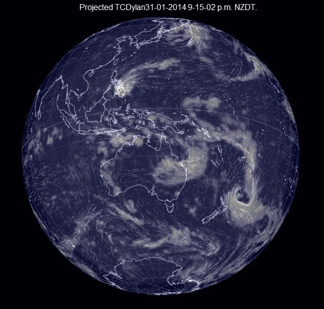
earth.nullschool.net.../01/31/0600Z/wind/surface/level/overlay=total_cloud_water/orthographic=-218.51,-19.94,279
IDQ20023
Australian Government Bureau of Meteorology Queensland Tropical Cyclone Warning Centre
TOP PRIORITY FOR IMMEDIATE BROADCAST
TROPICAL CYCLONE ADVICE NUMBER 16
Issued at 4:57 pm EST on Thursday 30 January 2014
A Cyclone WARNING remains current for coastal and island communities from
Cardwell to St Lawrence extending to adjacent inland areas, including
Collinsville..
At 4:00 pm EST Tropical Cyclone Dylan, Category 1 was estimated to be 205
kilometres northeast of Townsville and 260 kilometres north of Proserpine and
moving southwest at 12 kilometres per hour towards the coast.
Tropical Cyclone Dylan is expected to continue moving in a general
southwesterly direction and further intensify before crossing the Queensland
coast between Townsville and Bowen in the early hours of Friday morning.
The cyclone and a strong ridge of high pressure further south are combining to
generate GALES at times along much of the east coast between Cardwell and St
Lawrence. Winds are expected to increase further between Lucinda and St
Lawrence during the remainder of today and extending to adjacent inland areas
on Friday morning with DESTRUCTIVE WIND GUSTS to 150 kilometres per hour
possible.
Heavy rain, which may lead to flash flooding, is expected to develop about
coastal and adjacent inland areas of the Herbert and Lower Burdekin and the
Central Coast and Whitsundays districts during today.
Coastal residents between Lucinda and St Lawrence, including Townsville are
specifically warned of the dangerous storm tide, particularly on the high tide
today and on Friday. The sea is likely to rise steadily up to a level well
above the normal tide, with damaging waves and flooding of some low-lying areas
close to the shoreline. People living in areas likely to be affected by this
flooding should take measures to protect their property as much as possible and
be prepared to follow instructions regarding evacuation of the area if advised
to do so by the authorities.
A storm tide is expected between Cardwell and Lucinda, particularly on the high
tide on Thursday and Friday. Large waves may produce minor flooding along the
foreshore. People living in areas likely to be affected by this flooding should
take measures to protect their property as much as possible and be prepared to
help their neighbours.
A separate Severe Weather Warning is current for remaining coastal and island
communities from Cooktown to Cardwell and from St Lawrence to Gladstone,
extending inland to the northern Central Highlands and eastern parts of the
Central West districts on Friday.
People between Cardwell and Mackay should take precautions and listen to the
next advice at 8pm.
- Information is available from your local government
- For cyclone preparedness and safety advice, visit Queensland's Disaster
Management Services website (www.disaster.qld.gov.au)
- For emergency assistance call the Queensland State Emergency Service (SES) on
132 500 (for assistance with storm damage, rising flood water, fallen trees on
buildings or roof damage).
Details of Tropical Cyclone Dylan at 4:00 pm EST:
.Centre located near...... 18.1 degrees South 148.3 degrees East
.Location accuracy........ within 35 kilometres
.Recent movement.......... towards the southwest at 12 kilometres per hour
.Wind gusts near centre... 120 kilometres per hour
.Severity category........ 1
.Central pressure......... 980 hectoPascals
The next advice will be issued by 8:00 pm EST Thursday 30 January.
www.bom.gov.au...
edit on 01000000292914 by muzzy because: (no reason given)
earth.nullschool.net.../01/31/0600Z/wind/surface/level/overlay=total_cloud_water/orthographic=-218.51,-19.94,279
edit on 01000000292914 by muzzy because: (no reason given)
reply to post by muzzy
I have been following this with interest for the last few days. I expect this to intensify to maybe a cat 2.
I have been following this with interest for the last few days. I expect this to intensify to maybe a cat 2.
reply to post by bellagirl
At a cat 2 as of 810 this evening.
Information
Expecting to cross the coast somewhere south of Ayr during the night. Will be interesting to see where it heads after that.
At a cat 2 as of 810 this evening.
Information
Expecting to cross the coast somewhere south of Ayr during the night. Will be interesting to see where it heads after that.
reply to post by muzzy
Cyclone Edna has formed just behind Dylan. Cat 1 at this stage, here's the BOM's info so far.

Information
Cyclone Edna has formed just behind Dylan. Cat 1 at this stage, here's the BOM's info so far.
IDQ20065
Australian Government Bureau of Meteorology
Queensland Region
Tropical Cyclone Warning Centre
TROPICAL CYCLONE INFORMATION BULLETIN
For 11:42 am EST on Saturday 1 February 2014
At 10 am EST Saturday, Tropical Cyclone Edna (Category 1) with central pressure
995 hPa was located
over the central Coral Sea near latitude 20.2 south longitude 152.9 east, which
is about 400 km east northeast of Mackay.
TROPICAL CYCLONE EDNA, CATEGORY 1, is expected to continue moving in a
southeast direction today and remain offshore of the Queensland coast. Tropical
Cyclone Edna should become slow moving tonight before weakening on Sunday
morning.
The next Information Bulletin will be issued by 5 pm EST today.
Information
Looks like this one will blow out, wouldn't want to be sailing through to Hawaii though
now
predicted 24 hours
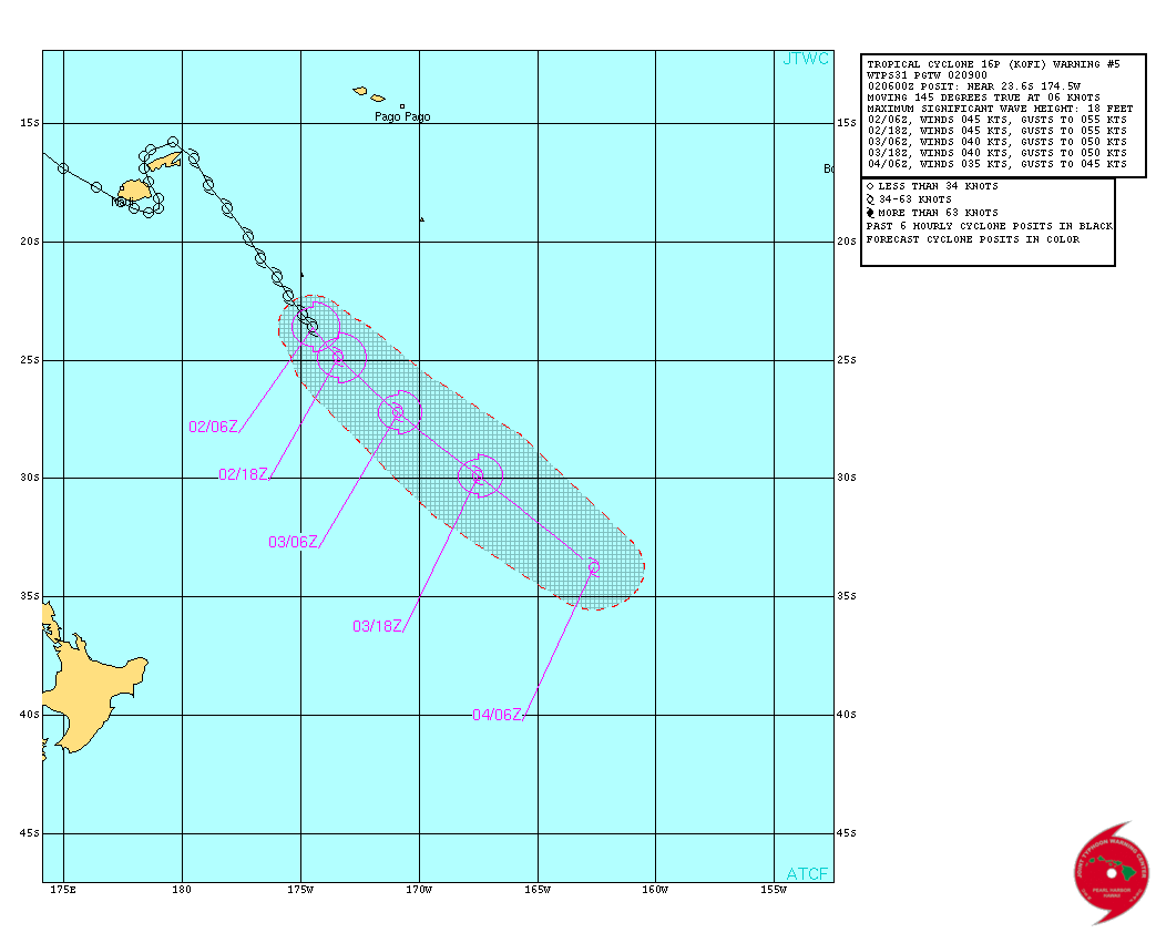
WTPS31 PGTW 020900
MSGID/GENADMIN/JOINT TYPHOON WRNCEN PEARL HARBOR HI//
SUBJ/TROPICAL CYCLONE 16P (KOFI) WARNING NR 005//
RMKS/
1. TROPICAL CYCLONE 16P (KOFI) WARNING NR 005
01 ACTIVE TROPICAL CYCLONE IN SOUTHPAC
MAX SUSTAINED WINDS BASED ON ONE-MINUTE AVERAGE
WIND RADII VALID OVER OPEN WATER ONLY
---
WARNING POSITION:
020600Z --- NEAR 23.6S 174.5W
MOVEMENT PAST SIX HOURS - 145 DEGREES AT 06 KTS
POSITION ACCURATE TO WITHIN 040 NM
POSITION BASED ON CENTER LOCATED BY SATELLITE
PRESENT WIND DISTRIBUTION:
MAX SUSTAINED WINDS - 045 KT, GUSTS 055 KT
WIND RADII VALID OVER OPEN WATER ONLY
Warning
020900z position near 23.9s 174.2w.
Tropical Cyclone (tc) 16p (Kofi), located approximately 517 nm
southeast of Suva, Fiji, has tracked southeastward at 06
knots over the past six hours. Animated multispectral satellite
imagery depicts weakening deep convection, however convective
banding is still wrapping into the low-level circulation center
(llcc). A 020210z noaa-19 microwave image also reveals a partially-
exposed llcc on the northwest edge of the deep convective banding.
the current intensity remains assessed at 45 knots based on dvorak
estimates of 45 knots from pgtw and knes. The current position is
based on the aforementioned microwave image with fair confidence. TC
16p is tracking along the western periphery of the subtropical ridge
located to the east. By tau 24, tc 16p should begin extra-tropical
transition (ett) as it interacts with the trough and baroclinic
zone. After tau 36, the system will encounter increasing vertical
wind shear and cooler sea surface temperatures, which will serve to
weaken the system rapidly.
Maximum significant wave height at 020600z is 18 feet.
next warnings at 022100z and 030900z.
www.usno.navy.mil...
now
predicted 24 hours
edit on 03u606014 by muzzy because: (no reason given)
TC HADI,
HIGH SEAS WEATHER WARNING FOR METAREA 10 ISSUED BY THE
AUSTRALIAN BUREAU OF METEOROLOGY TROPICAL CYCLONE WARNING CENTRE BRISBANE
AT 1904UTC 10 MARCH 2014
GALE WARNING FOR NORTH EASTERN AREA
SITUATION
At 1800 UTC Tropical Cyclone Hadi was centred within 40 nautical miles of
latitude eighteen decimal five south (18.5S)
longitude one hundred and fifty one decimal nine east (151.9E)
Recent movement : northeast at 3 knots
Maximum winds : 40 knots
Central pressure: 997 hPa
FORECAST
Maximum winds to 40 knots near the centre.
Forecast positions
At 0600 UTC 11 March: Within 65 nautical miles of 17.8 south 152.1 east
Central pressure 995 hPa.
Winds to 40 knots.
At 1800 UTC 11 March: Within 90 nautical miles of 16.5 south 153.0 east
Central pressure 996 hPa.
Winds to 40 knots.
www.bom.gov.au...

JOINT TYPHOON WRNCEN PEARL HARBOR
remarks:
102100z position near 19.0s 152.0e.
Tropical Cyclone (TC) 19p (Hadi), located approximately 514 nm
north of Brisbane, Australia, has tracked east-southeastward
at 03 knots over the past six hours. Animated enhanced infrared
(eir) satellite imagery depicts persistent deep central convection
associated with a consolidating low-level circulation center (llcc).
a 101622z ssmi microwave image reveals increased deep convective
banding over the southwest quadrant wrapping into the llcc. The
initial position is based upon the eir and above microwave image
with fair confidence. The initial intensity of 35 knots is based
upon the increase in consolidation and dvorak intensity estimates
from pgtw and knes. Upper-level analysis indicates the system is now
located in an improved environment with favorable vertical wind
shear and strong poleward outflow. TC Hadi is slowly tracking along
a weak periphery of the near equatorial ridge (ner) to the north of
the system. Under influence of a weak steering environment, TC 19p
is forecast to track slowly, possibly quasi-stationary movement over
the next 24 hours. by tau 24, this ner is expected to amplify and
accelerate TC 19p to the northeast. In the later taus, another ner
will build to the northeast, dominating the steering environment and
turning TC 19p east-southeastward. TC 19p is forecast to intensify
throughout the forecast period, leading to a peak of 60 knots by tau
120. Available numeric model guidance has improved; however, there
is still a 250 nm spread at tau 48. Due to the uncertainty of
movement in the near term and a large spread among model trackers,
the jtwc forecast track is positioned close to multi-model consensus
with low confidence. Maximum significant wave height at 101800z is
12 feet. Next warnings at 110900z and 112100z.
refer to tropical
cyclone 17p (Gillian) warnings (wtps32 pgtw) for twelve-hourly
updates.
refer to tropical cyclone 18p (Lusi) warnings (wtps31 pgtw)
for twelve-hourly updates.
www.usno.navy.mil...

HIGH SEAS WEATHER WARNING FOR METAREA 10 ISSUED BY THE
AUSTRALIAN BUREAU OF METEOROLOGY TROPICAL CYCLONE WARNING CENTRE BRISBANE
AT 1904UTC 10 MARCH 2014
GALE WARNING FOR NORTH EASTERN AREA
SITUATION
At 1800 UTC Tropical Cyclone Hadi was centred within 40 nautical miles of
latitude eighteen decimal five south (18.5S)
longitude one hundred and fifty one decimal nine east (151.9E)
Recent movement : northeast at 3 knots
Maximum winds : 40 knots
Central pressure: 997 hPa
FORECAST
Maximum winds to 40 knots near the centre.
Forecast positions
At 0600 UTC 11 March: Within 65 nautical miles of 17.8 south 152.1 east
Central pressure 995 hPa.
Winds to 40 knots.
At 1800 UTC 11 March: Within 90 nautical miles of 16.5 south 153.0 east
Central pressure 996 hPa.
Winds to 40 knots.
www.bom.gov.au...
JOINT TYPHOON WRNCEN PEARL HARBOR
remarks:
102100z position near 19.0s 152.0e.
Tropical Cyclone (TC) 19p (Hadi), located approximately 514 nm
north of Brisbane, Australia, has tracked east-southeastward
at 03 knots over the past six hours. Animated enhanced infrared
(eir) satellite imagery depicts persistent deep central convection
associated with a consolidating low-level circulation center (llcc).
a 101622z ssmi microwave image reveals increased deep convective
banding over the southwest quadrant wrapping into the llcc. The
initial position is based upon the eir and above microwave image
with fair confidence. The initial intensity of 35 knots is based
upon the increase in consolidation and dvorak intensity estimates
from pgtw and knes. Upper-level analysis indicates the system is now
located in an improved environment with favorable vertical wind
shear and strong poleward outflow. TC Hadi is slowly tracking along
a weak periphery of the near equatorial ridge (ner) to the north of
the system. Under influence of a weak steering environment, TC 19p
is forecast to track slowly, possibly quasi-stationary movement over
the next 24 hours. by tau 24, this ner is expected to amplify and
accelerate TC 19p to the northeast. In the later taus, another ner
will build to the northeast, dominating the steering environment and
turning TC 19p east-southeastward. TC 19p is forecast to intensify
throughout the forecast period, leading to a peak of 60 knots by tau
120. Available numeric model guidance has improved; however, there
is still a 250 nm spread at tau 48. Due to the uncertainty of
movement in the near term and a large spread among model trackers,
the jtwc forecast track is positioned close to multi-model consensus
with low confidence. Maximum significant wave height at 101800z is
12 feet. Next warnings at 110900z and 112100z.
refer to tropical
cyclone 17p (Gillian) warnings (wtps32 pgtw) for twelve-hourly
updates.
refer to tropical cyclone 18p (Lusi) warnings (wtps31 pgtw)
for twelve-hourly updates.
www.usno.navy.mil...
new topics
-
Poll - Catholic Support Swings to Trump By Significant Margin
2024 Elections: 52 minutes ago -
Thank you dear friends
Short Stories: 9 hours ago
top topics
-
WHY is DOJ Not Turning Over the AUDIO of JOE BIDENs Sworn Testimony to Prosecutor Robert Hur.
Above Politics: 15 hours ago, 15 flags -
Boeing 737 Max whistleblower Joshua Dean, 45, dead after sudden illness
Whistle Blowers and Leaked Documents: 16 hours ago, 6 flags -
A Couple Of Great Movies Ive Watched Today
General Chit Chat: 15 hours ago, 6 flags -
An Implausible New Electoral Process?
Political Ideology: 15 hours ago, 4 flags -
Thank you dear friends
Short Stories: 9 hours ago, 4 flags -
Poll - Catholic Support Swings to Trump By Significant Margin
2024 Elections: 52 minutes ago, 3 flags
active topics
-
Trump Warns Time Magazine of Rising Anti-White Sentiment
2024 Elections • 64 • : matafuchs -
Candidate TRUMP Now Has Crazy Judge JUAN MERCHAN After Him - The Stormy Daniels Hush-Money Case.
Political Conspiracies • 1041 • : Vermilion -
Mood Music Part VI
Music • 3146 • : TheWoker -
Spy Music
Music • 45 • : underpass61 -
Two lifeforms merge into one for first time in a billion years
Science & Technology • 48 • : SchrodingersRat -
Bigger than Covid
US Political Madness • 36 • : Euronymous2625 -
Rendlesham Forest 1980 Pt II - Will There Be An Answer?
Aliens and UFOs • 3664 • : Ophiuchus1 -
An Implausible New Electoral Process?
Political Ideology • 18 • : SchrodingersRat -
Poll - Catholic Support Swings to Trump By Significant Margin
2024 Elections • 4 • : Station27 -
The Fight for Election Integrity Continues -- Audits, Criminal Investigations, Legislative Reform
2024 Elections • 4158 • : IndieA