It looks like you're using an Ad Blocker.
Please white-list or disable AboveTopSecret.com in your ad-blocking tool.
Thank you.
Some features of ATS will be disabled while you continue to use an ad-blocker.

Quake Watch 2014
page: 74share:
a reply to: muzzy
Have a safe flight and a great time trekking western North America, Muzzy.
Anybody else just lose data from the TA (transportable array) network? Most inconvenient.
ETA:
NVM...must have been a temporary glitch in the matrix. Back to figuring.
Have a safe flight and a great time trekking western North America, Muzzy.
Anybody else just lose data from the TA (transportable array) network? Most inconvenient.
ETA:
NVM...must have been a temporary glitch in the matrix. Back to figuring.
edit on 6/30/2014 by Olivine because: fixed
This one went WEST
Location in Google Maps
Derived from Event Data Source: USGS
Powered by QVSData
Magnitude 6.2 - Bonin Islands. Japan Region (212)
Location in Google Maps
- Date-Time: Monday, June 30, 2014 @ 19:55:32 UTC
- Earthquake location: 28.354°N, 138.864°E,
- Earthquake depth: 512.4 km
- Distances:
359km (223mi) WNW of Chichi-shima, Japan
656km (407mi) SSE of Shingu, Japan
682km (423mi) SSE of Owase, Japan
683km (424mi) SSE of Tanabe, Japan
817km (507mi) S of Tokyo, Japan
- Event ID: usc000rnx0
Derived from Event Data Source: USGS
Powered by QVSData
Seems the Sea Lions at Pier 39 in San Francisco have disappeared en mass again! They could have gone off to mate or fish but it may be that the big
one is coming soon.
www.dailymail.co.uk... ernight.html
www.dailymail.co.uk... ernight.html
a reply to: berkeleygal
Oh no!
With things seeming to pick up in that area of the pacific rim, I don't blame them for leaving.
I wonder if it is migratory or EQ related?!
We'll just have to wait and see.
Oh no!
With things seeming to pick up in that area of the pacific rim, I don't blame them for leaving.
I wonder if it is migratory or EQ related?!
We'll just have to wait and see.
FWIW . . . sounds like someone is ramping this issue up again . . .
www.youtube.com...=303
[Yellowstone]
Any confirmation or clear disconfirmation of anything said hereon?
Sorry. Thought that it was a recent one. Looks like this is from Feb 2014
Oh welll . . . sorry for the bother.
www.youtube.com...=303
[Yellowstone]
Any confirmation or clear disconfirmation of anything said hereon?
Sorry. Thought that it was a recent one. Looks like this is from Feb 2014
Oh welll . . . sorry for the bother.
edit on 2/7/2014 by BO XIAN because: added
Looks like Useless is doing it's thing again, downplaying Mag 6 quakes.
M5.4 - Balleny Islands region 2014-07-02 05:53:30 UTC
Their moment tensors both say 6.0 and GFZ Potsdam says 6.1 Mw in agreement with EMSC also 6.1
I have been waiting to see if they were going to change it but they have not which means it is now likely to be day 8 when it does eventually change and we chalk up the first M6 of July.
I just don't understand why they do this. It is not clever, no one in the know is fooled by it, and in reality it is completely pathetic and puts themselves in a bad light, at least as far as I am concerned. If it happened once or twice in a year one could forgive them but this is such a regular feature of the way they mismanage their site one can only shake ones head and wonder if in fact they are serious at all.
So here are the details as at present
Total numpties!
M5.4 - Balleny Islands region 2014-07-02 05:53:30 UTC
Their moment tensors both say 6.0 and GFZ Potsdam says 6.1 Mw in agreement with EMSC also 6.1
I have been waiting to see if they were going to change it but they have not which means it is now likely to be day 8 when it does eventually change and we chalk up the first M6 of July.
I just don't understand why they do this. It is not clever, no one in the know is fooled by it, and in reality it is completely pathetic and puts themselves in a bad light, at least as far as I am concerned. If it happened once or twice in a year one could forgive them but this is such a regular feature of the way they mismanage their site one can only shake ones head and wonder if in fact they are serious at all.
So here are the details as at present
Prov,Date/Time UTC,Latitude,Longitude,Magnitude,Depth(Km),Location
emsc,2014-07-02 05:53:29, -62.340, 155.070, 6.1, 10.0, Balleny Isls. Region
gfzp,2014-07-02 05:53:30, -62.290, 155.160, 6.1, 10.0, Balleny Isls. Region
usgs,2014-07-02 05:53:30, -62.269, 155.088, 5.4, 16.1, Balleny Isls. Region (702)
Total numpties!
a reply to: PuterMan
i think its just laziness, can't be bothered to match up the different sources as they work things out
I think that 5.4 came from this page, not sure as I didn't see their original mag when it happened.
earthquake.usgs.gov...-solutions
i think its just laziness, can't be bothered to match up the different sources as they work things out
I think that 5.4 came from this page, not sure as I didn't see their original mag when it happened.
earthquake.usgs.gov...-solutions
For those of you interested in quite a good app
lokk for
EQInfo
just thought I'd share.
lokk for
EQInfo
just thought I'd share.
Magnitude 6.3 - Kermadec Islands Region (177)
Location in Google Maps
- Date-Time: Thursday, July 03, 2014 @ 19:50:05 UTC
- Earthquake location: 30.533°S, 176.526°W,
- Earthquake depth: 20.0 km
- Distances:
193km (119mi) SE of Raoul Island, New Zealand
1017km (631mi) NE of Whakatane, New Zealand
1029km (639mi) ENE of Whangarei, New Zealand
1030km (640mi) NNE of Gisborne, New Zealand
1049km (651mi) S of Nuku`alofa, Tonga
- Event ID: usc000rqbg
Derived from Event Data Source: USGS
Powered by QVSData
What a crazy thing ..that when New Zealand goes off...So does that same area in Alaska that had the 7.9.
Maybe the 10.5 or 11.0 is going to happen after all! That is an enormous amount of kilometers between those two points to unzip all at once!
earthquake.usgs.gov...
Maybe the 10.5 or 11.0 is going to happen after all! That is an enormous amount of kilometers between those two points to unzip all at once!
earthquake.usgs.gov...
edit on 3-7-2014 by radpetey because: (no reason given)
Got a little swarm going on near The Redlands in Cali - 26 at last count.
1.0
1km S of Redlands, California
2014-07-03 18:01:02 UTC-05:00
9.5 km
1.1
3km WNW of Redlands, California
2014-07-03 17:58:40 UTC-05:00
12.1 km
1.1
3km SSE of Redlands, California
2014-07-03 17:56:17 UTC-05:00
7.2 km
1.1
3km SSE of Redlands, California
2014-07-03 17:52:37 UTC-05:00
8.4 km
2.5
3km SSE of Redlands, California
2014-07-03 17:50:37 UTC-05:00
7.8 km
1.3
3km SSE of Redlands, California
2014-07-03 17:46:39 UTC-05:00
6.5 km
1.4
3km W of Redlands, California
2014-07-03 17:44:03 UTC-05:00
15.0 km
1.8
3km SSE of Redlands, California
2014-07-03 17:35:05 UTC-05:00
4.2 km
1.4
3km SSE of Redlands, California
2014-07-03 17:28:35 UTC-05:00
5.4 km
0.9
4km SSE of Redlands, California
2014-07-03 17:21:33 UTC-05:00
7.5 km
1.0
3km SSE of Redlands, California
2014-07-03 17:09:19 UTC-05:00
8.1 km
0.8
3km SSE of Redlands, California
2014-07-03 16:35:20 UTC-05:00
7.4 km
0.8
4km SSE of Redlands, California
2014-07-03 16:26:21 UTC-05:00
7.2 km
1.1
3km SSE of Redlands, California
2014-07-03 16:15:54 UTC-05:00
8.8 km
1.0
3km SSE of Redlands, California
2014-07-03 16:14:34 UTC-05:00
7.6 km
0.8
3km SSE of Redlands, California
2014-07-03 16:14:21 UTC-05:00
7.7 km
2.0
3km SE of Redlands, California
2014-07-03 14:05:20 UTC-05:00
7.9 km
0.8
3km SE of Redlands, California
2014-07-03 12:15:35 UTC-05:00
7.1 km
0.6
3km SE of Redlands, California
2014-07-03 11:40:22 UTC-05:00
7.9 km
1.4
3km SE of Redlands, California
2014-07-03 10:25:06 UTC-05:00
7.6 km
0.8
3km SE of Redlands, California
2014-07-03 07:29:22 UTC-05:00
7.3 km
0.7
3km SSE of Redlands, California
2014-07-03 06:37:19 UTC-05:00
4.7 km
1.8
3km SSE of Redlands, California
2014-07-03 06:24:45 UTC-05:00
7.5 km
0.7
3km SSE of Redlands, California
2014-07-03 06:07:35 UTC-05:00
6.4 km
1.6
3km SSE of Redlands, California
2014-07-03 06:01:00 UTC-05:00
7.3 km
2.4
3km SSE of Redlands, California
2014-07-03 05:39:36 UTC-05:008.2 km
1.0
1km S of Redlands, California
2014-07-03 18:01:02 UTC-05:00
9.5 km
1.1
3km WNW of Redlands, California
2014-07-03 17:58:40 UTC-05:00
12.1 km
1.1
3km SSE of Redlands, California
2014-07-03 17:56:17 UTC-05:00
7.2 km
1.1
3km SSE of Redlands, California
2014-07-03 17:52:37 UTC-05:00
8.4 km
2.5
3km SSE of Redlands, California
2014-07-03 17:50:37 UTC-05:00
7.8 km
1.3
3km SSE of Redlands, California
2014-07-03 17:46:39 UTC-05:00
6.5 km
1.4
3km W of Redlands, California
2014-07-03 17:44:03 UTC-05:00
15.0 km
1.8
3km SSE of Redlands, California
2014-07-03 17:35:05 UTC-05:00
4.2 km
1.4
3km SSE of Redlands, California
2014-07-03 17:28:35 UTC-05:00
5.4 km
0.9
4km SSE of Redlands, California
2014-07-03 17:21:33 UTC-05:00
7.5 km
1.0
3km SSE of Redlands, California
2014-07-03 17:09:19 UTC-05:00
8.1 km
0.8
3km SSE of Redlands, California
2014-07-03 16:35:20 UTC-05:00
7.4 km
0.8
4km SSE of Redlands, California
2014-07-03 16:26:21 UTC-05:00
7.2 km
1.1
3km SSE of Redlands, California
2014-07-03 16:15:54 UTC-05:00
8.8 km
1.0
3km SSE of Redlands, California
2014-07-03 16:14:34 UTC-05:00
7.6 km
0.8
3km SSE of Redlands, California
2014-07-03 16:14:21 UTC-05:00
7.7 km
2.0
3km SE of Redlands, California
2014-07-03 14:05:20 UTC-05:00
7.9 km
0.8
3km SE of Redlands, California
2014-07-03 12:15:35 UTC-05:00
7.1 km
0.6
3km SE of Redlands, California
2014-07-03 11:40:22 UTC-05:00
7.9 km
1.4
3km SE of Redlands, California
2014-07-03 10:25:06 UTC-05:00
7.6 km
0.8
3km SE of Redlands, California
2014-07-03 07:29:22 UTC-05:00
7.3 km
0.7
3km SSE of Redlands, California
2014-07-03 06:37:19 UTC-05:00
4.7 km
1.8
3km SSE of Redlands, California
2014-07-03 06:24:45 UTC-05:00
7.5 km
0.7
3km SSE of Redlands, California
2014-07-03 06:07:35 UTC-05:00
6.4 km
1.6
3km SSE of Redlands, California
2014-07-03 06:01:00 UTC-05:00
7.3 km
2.4
3km SSE of Redlands, California
2014-07-03 05:39:36 UTC-05:008.2 km
edit on 3-7-2014 by berkeleygal because: (no reason given)
M3.9 -
42km NW of Lordsburg, New Mexico
2014-07-03 22:56:31 UTC
Event Time
2014-07-03 22:56:31 UTC
2014-07-03 15:56:31 UTC-07:00 at epicenter
2014-07-03 15:56:31 UTC-07:00 system time
Location
32.579°N 109.075°W depth=5.0km (3.1mi)
Nearby Cities
42km (26mi) NW of Lordsburg, New Mexico
77km (48mi) WSW of Silver City, New Mexico
128km (80mi) WNW of Deming, New Mexico
143km (89mi) NNE of Douglas, Arizona
296km (184mi) ESE of Phoenix, Arizona
earthquake.usgs.gov...
M3.1
- 12km WNW of Calipatria, California
2014-07-03 23:50:27 UTC
Event Time
2014-07-03 23:50:27 UTC
2014-07-03 16:50:27 UTC-07:00 at epicenter
2014-07-03 16:50:27 UTC-07:00 system time
Location
33.170°N 115.641°W depth=0.2km (0.1mi)
Nearby Cities
12km (7mi) WNW of Calipatria, California
23km (14mi) NNW of Brawley, California
36km (22mi) N of Imperial, California
42km (26mi) N of El Centro, California
333km (207mi) W of Phoenix, Arizona
earthquake.usgs.gov...
edit on 7/30/2012 by dreamfox1 because: (no reason given)
a reply to: ericblair4891
Hey Eric, I agree with you that something is brewing. When you say moving east, where were you thinking?
To me, all of the small quakes lately, away from major plate boundaries (Idaho, Utah, AZ/MN border, even the swarm up in Noatak, Alaska) are resultant from the North American plate marching westward.
Couple those quakes with the uptick in mag 2-4 sized quakes throughout California (see image below), and my ever-present suspicion that a large quake is headed for southern California is growing.
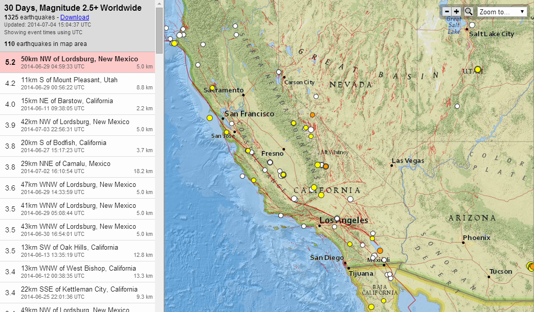
USGS source map
The Mag 3.5 SE of Wrightwood, CA back on the 13th of June, was the quake the that got me thinking a big earthquake may be possible in the short term (say next 90 days). It cracked on the San Andreas. Prior to that, the Los Angeles region had the Mag 4.2 in Westwood, CA on June 2nd, and the Mag 5.1 La Habra earthquake on 29 March.
Now with the ongoing swarm near Redlands, that Berkeleygal has posted about above, which is up to 84 quakes, and a smaller series on the eastern side of the Sierras near Lone Pine (began July 2nd)--well I just can't shake the feeling something big is indeed on the way.
The focal mechanism for the largest quake in the Redlands swarm, shows fault movement consistent with the Pacific plate trying to move NW.
Anyway, that's my doom for this holiday morning. Everyone, enjoy your Independence Day!
p.s. I won't be around much for a while, my compy has metamorphosed into a brick....So no major earthquakes are allowed, mother Earth.
Hey Eric, I agree with you that something is brewing. When you say moving east, where were you thinking?
To me, all of the small quakes lately, away from major plate boundaries (Idaho, Utah, AZ/MN border, even the swarm up in Noatak, Alaska) are resultant from the North American plate marching westward.
Couple those quakes with the uptick in mag 2-4 sized quakes throughout California (see image below), and my ever-present suspicion that a large quake is headed for southern California is growing.
USGS source map
The Mag 3.5 SE of Wrightwood, CA back on the 13th of June, was the quake the that got me thinking a big earthquake may be possible in the short term (say next 90 days). It cracked on the San Andreas. Prior to that, the Los Angeles region had the Mag 4.2 in Westwood, CA on June 2nd, and the Mag 5.1 La Habra earthquake on 29 March.
Now with the ongoing swarm near Redlands, that Berkeleygal has posted about above, which is up to 84 quakes, and a smaller series on the eastern side of the Sierras near Lone Pine (began July 2nd)--well I just can't shake the feeling something big is indeed on the way.
The focal mechanism for the largest quake in the Redlands swarm, shows fault movement consistent with the Pacific plate trying to move NW.
Anyway, that's my doom for this holiday morning. Everyone, enjoy your Independence Day!
p.s. I won't be around much for a while, my compy has metamorphosed into a brick....So no major earthquakes are allowed, mother Earth.
edit on 7/4/2014 by Olivine because: to fix screwy formatting
edit on 7/4/2014 by Olivine because: (no reason given)
Found some older interesting info in the area of the Arizona quakes (Listed as NW of Lordsburg, New Mexico on USGS)
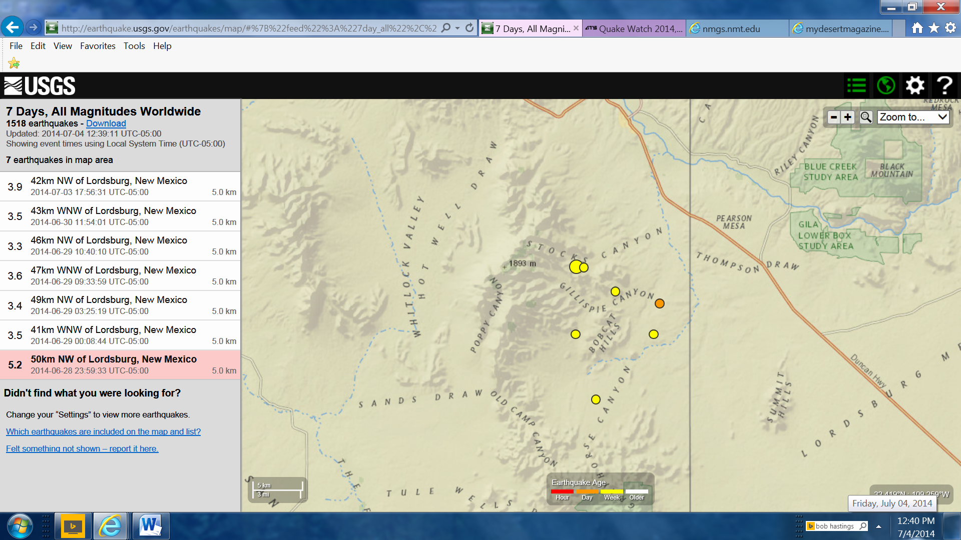
This link is to Desert Magazine from 1958. On P. 13-16 is an article “Gem Trails in Arizona’s Whitlocks”.
Very interesting article from geologic/volcanic/archeological past. Article states that there was a well dug in the area where the water was so hot it had to be cooled before cattle could drink it. From the map in the article it is west of the current earthquake area.
mydesertmagazine.com...
Year 2000 Scientific/geological link from New Mexico State University on the faulting in the area.
nmgs.nmt.edu...
originally posted by: radpetey
What a crazy thing ..that when New Zealand goes off...So does that same area in Alaska that had the 7.9.
Maybe the 10.5 or 11.0 is going to happen after all! That is an enormous amount of kilometers between those two points to unzip all at once!
If that entire side of the Pacific Plate went as one event at once life on this planet would be pretty much over for most of us humans, the power that would entail would be something like a meteor impact of major proportions.
It has probably happened before, in the early days of the planets life, creating the Tectonic Plates in the first place.
Little bit at a time eh.
even those M9's we see are just small movements when you consider the size of the Planet, whats 2-24 metres of movement (Japan Tohoku earthquake on March 11, 2011) compared to the 40,075.16 kilometers circumference of the Planet?
Last earthquake in Alberta;
between Red Deer and the Rockies
2014/07/02 15:37:01
52.22, -115.26
1.0km deep
M1.7
31 km WSW of Rocky Mt. House,AB
www.earthquakescanada.nrcan.gc.ca...
between Red Deer and the Rockies
2014/07/02 15:37:01
52.22, -115.26
1.0km deep
M1.7
31 km WSW of Rocky Mt. House,AB
www.earthquakescanada.nrcan.gc.ca...
originally posted by: muzzy
originally posted by: radpetey
What a crazy thing ..that when New Zealand goes off...So does that same area in Alaska that had the 7.9.
Maybe the 10.5 or 11.0 is going to happen after all! That is an enormous amount of kilometers between those two points to unzip all at once!
If that entire side of the Pacific Plate went as one event at once life on this planet would be pretty much over for most of us humans, the power that would entail would be something like a meteor impact of major proportions.
It has probably happened before, in the early days of the planets life, creating the Tectonic Plates in the first place.
Little bit at a time eh.
even those M9's we see are just small movements when you consider the size of the Planet, whats 2-24 metres of movement (Japan Tohoku earthquake on March 11, 2011) compared to the 40,075.16 kilometers circumference of the Planet?
I know!! That is why I had my winky emoticon..
I know a lot of you hate to hear quotes from the Bible; however, in Ezekiel 38 or 39...it speaks of a quake so large that every fish, animal, and human feel this monster! It pretty much moves mountains of their places.
Just sayin'!
edit on 4-7-2014 by radpetey because: (no reason given)
a reply to: SeekingDepth
Great delving for that information!
I spent the better part of the afternoon reading from the magazine.
Great articles! Still not finished yet!
That's something about the water from the well being so hot!
I have an Aunt & Uncle that moved to Arizona around '58.
When I was 10 or 11, our family took a road trip to visit them.
Your link brought back some long forgotten, awesome memories!
Riding in our old Ford station wagon, with no air conditioning back then,
visiting the Old Tucson movie/TV set, miles of giant Saguaro cactus,
the scary ride up twisty, curvy Mount Lemmon with my Uncle driving, & him
laughing because we were scared of the steep drop-offs & no guardrails!
Looking over the edge & seeing crashed, abandoned cars that DID go over!
Being told not to go into the alley behind their house because of Gila Monsters!
Wanting to GO into the alley to SEE a Gila Monster, but my cousins were afraid to!
Seeing a Prairie Dog for the first time & wanting to catch one to bring home!!!
Crying because I wasn't even allowed to try!
Wonderful desert sunsets, petrified wood souvenirs,
Dad minding the heat so much that he had to take salt tablets,
wanting to see a mirage in the desert like in the movies, so badly,
the roof of their house dripping moisture early in the morning,
driving across country & seeing so many states & unbelievable land formations,
little motels with lots of local character, part of Route 66...
Thanks for bringing back some priceless memories for me!!!
WOQ
edit on 5-7-2014 by wasobservingquietly because: (no reason given)
Magnitude 6.0 - Northern Sumatra. Indonesia (706)
Location in Google Maps
- Date-Time: Saturday, July 05, 2014 @ 09:39:30 UTC
- Earthquake location: 1.995°N, 97.015°E,
- Earthquake depth: 30.0 km
- Distances:
88km (54mi) SE of Sinabang, Indonesia
198km (123mi) W of Sibolga, Indonesia
204km (126mi) SW of Kabanjahe, Indonesia
241km (149mi) SW of Binjai, Indonesia
534km (331mi) WSW of Kuala Lumpur, Malaysia
- Event ID: usc000rqs7
Derived from Event Data Source: USGS
Powered by QVSData
new topics
-
Gov Kristi Noem Shot and Killed "Less Than Worthless Dog" and a 'Smelly Goat
2024 Elections: 5 minutes ago -
Falkville Robot-Man
Aliens and UFOs: 19 minutes ago -
James O’Keefe: I have evidence that exposes the CIA, and it’s on camera.
Whistle Blowers and Leaked Documents: 1 hours ago -
Australian PM says the quiet part out loud - "free speech is a threat to democratic dicourse"...?!
New World Order: 1 hours ago -
Ireland VS Globalists
Social Issues and Civil Unrest: 2 hours ago -
Biden "Happy To Debate Trump"
Mainstream News: 2 hours ago -
RAAF airbase in Roswell, New Mexico is on fire
Aliens and UFOs: 2 hours ago -
What is the white pill?
Philosophy and Metaphysics: 4 hours ago -
Mike Pinder The Moody Blues R.I.P.
Music: 5 hours ago -
Putin, Russia and the Great Architects of the Universe
ATS Skunk Works: 8 hours ago
top topics
-
A Warning to America: 25 Ways the US is Being Destroyed
New World Order: 12 hours ago, 21 flags -
Biden "Happy To Debate Trump"
Mainstream News: 2 hours ago, 7 flags -
Mike Pinder The Moody Blues R.I.P.
Music: 5 hours ago, 7 flags -
What is the white pill?
Philosophy and Metaphysics: 4 hours ago, 5 flags -
Australian PM says the quiet part out loud - "free speech is a threat to democratic dicourse"...?!
New World Order: 1 hours ago, 5 flags -
RAAF airbase in Roswell, New Mexico is on fire
Aliens and UFOs: 2 hours ago, 4 flags -
Putin, Russia and the Great Architects of the Universe
ATS Skunk Works: 8 hours ago, 3 flags -
Ireland VS Globalists
Social Issues and Civil Unrest: 2 hours ago, 3 flags -
James O’Keefe: I have evidence that exposes the CIA, and it’s on camera.
Whistle Blowers and Leaked Documents: 1 hours ago, 3 flags -
Falkville Robot-Man
Aliens and UFOs: 19 minutes ago, 1 flags
active topics
-
Candidate TRUMP Now Has Crazy Judge JUAN MERCHAN After Him - The Stormy Daniels Hush-Money Case.
Political Conspiracies • 795 • : Threadbarer -
Gov Kristi Noem Shot and Killed "Less Than Worthless Dog" and a 'Smelly Goat
2024 Elections • 4 • : Disgusted123 -
Ditching physical money
History • 22 • : StudioNada -
Biden "Happy To Debate Trump"
Mainstream News • 33 • : YourFaceAgain -
Falkville Robot-Man
Aliens and UFOs • 3 • : KKLOCO -
University of Texas Instantly Shuts Down Anti Israel Protests
Education and Media • 296 • : KrustyKrab -
Krystalnacht on today's most elite Universities?
Social Issues and Civil Unrest • 10 • : xuenchen -
Russia Ukraine Update Thread - part 3
World War Three • 5736 • : YourFaceAgain -
Manor Lords - Medieval City Builder with RTS Combat - Early Access 26th April
Video Games • 7 • : gortex -
"We're All Hamas" Heard at Columbia University Protests
Social Issues and Civil Unrest • 289 • : FlyersFan