It looks like you're using an Ad Blocker.
Please white-list or disable AboveTopSecret.com in your ad-blocking tool.
Thank you.
Some features of ATS will be disabled while you continue to use an ad-blocker.

Quake Watch 2014
page: 47share:
Magnitude M7.07.2
Region BOUGAINVILLE REGION, P.N.G.
Date time 2014-04-11 07:07:18.0 UTC
Location 6.64 S ; 155.21 E
Depth 10 km
Distances 607 km NW of Honiara, Solomon Islands / pop: 56,298 / local time: 18:07:18.0 2014-04-11
413 km SE of Kokopo, Papua New Guinea / pop: 26,273 / local time: 17:07:18.0 2014-04-11
www.emsc-csem.org...
Magnitude 7.3 - Solomon Islands (193) [T]
Location in Google Maps
- Date-Time: Friday, April 11, 2014 @ 07:07:21 UTC
- Earthquake location: 6.600°S, 155.100°E,
- Earthquake depth: 54.0 km
- Distances:
61km (37mi) SW of Panguna, Papua New Guinea
73km (45mi) SW of Arawa, Papua New Guinea
399km (247mi) SE of Kokopo, Papua New Guinea
555km (344mi) ESE of Kimbe, Papua New Guinea
622km (386mi) WNW of Honiara, Solomon Islands
- Event ID: at00n3unei
Derived from Event Data Source: USGS
Powered by QVSData
edit on 11/4/2014 by PuterMan because: (no reason given)
www.emsc-csem.org...
Location in Google Maps
Derived from Event Data Source: USGS
Powered by QVSData
Magnitude M 6.8
Region BOUGAINVILLE REGION, P.N.G.
Date time 2014-04-11 08:16:50.0 UTC
Location 6.94 S ; 155.00 E
Depth 48 km
Distances 611 km NW of Honiara, Solomon Islands / pop: 56,298 / local time: 19:16:50.0 2014-04-11
417 km SE of Kokopo, Papua New Guinea / pop: 26,273 / local time: 18:16:50.0 2014-04-11
87 km SW of Panguna, Papua New Guinea / pop: 2,916 / local time: 18:16:50.0 2014-04-11
Global view
Source parameters not yet reviewed by a seismologist
Magnitude 6.8 - Solomon Islands (193) [T]
Location in Google Maps
- Date-Time: Friday, April 11, 2014 @ 08:16:51 UTC
- Earthquake location: 7.100°S, 155.100°E,
- Earthquake depth: 49.0 km
- Distances:
96km (59mi) SSW of Panguna, Papua New Guinea
109km (67mi) SSW of Arawa, Papua New Guinea
437km (271mi) SE of Kokopo, Papua New Guinea
574km (356mi) ESE of Kimbe, Papua New Guinea
593km (368mi) WNW of Honiara, Solomon Islands
- Event ID: at00n3uxo1
Derived from Event Data Source: USGS
Powered by QVSData
edit on
11/4/2014 by PuterMan because: (no reason given)
Quick question does anyone have any good apps they would recommend for earthquake tracking. I use one but the app seems to not work as well any more
reply to post by ThePeaceMaker
It depends what you want to do, or perhaps I should say what sort of information presentation you are looking for.
What were you using?
It depends what you want to do, or perhaps I should say what sort of information presentation you are looking for.
What were you using?
reply to post by PuterMan
Sorry should of gave more detail my bad, basically just after an app that alerts me to earthquakes and gives me their size and locations. All the basic details really. I use an app called Earthquake (the lite version?) on iPhone 5, the app doesn't seem to want to work properly with my phone. Just didn't know if there was a particular good app people use
Sorry should of gave more detail my bad, basically just after an app that alerts me to earthquakes and gives me their size and locations. All the basic details really. I use an app called Earthquake (the lite version?) on iPhone 5, the app doesn't seem to want to work properly with my phone. Just didn't know if there was a particular good app people use
reply to post by ThePeaceMaker
I use QuakeFeed (iOS). The free version includes notifications of 6.0s and higher.
I use QuakeFeed (iOS). The free version includes notifications of 6.0s and higher.
Gumshoe
reply to post by ThePeaceMaker
I use QuakeFeed (iOS). The free version includes notifications of 6.0s and higher.
Cheers thanks mate, sorry it was a bit of a pathetic thing to ask. I could of searched the App Store but wanted to ask what people would recommend
I was going to write yesterday. But I was lulled into inaction. By the lull. The lull before the few big ones we've had over the past 24 hours. The
previous few days had seen an ebbing of Chile. It seemed even more quiet to me because I had been watching the volcanoes Ubinas, Turanga Leela (joke)
Tungurahua, Reventador, Fuego, and Popocatepetl and they had quieted down. It was strange. They all seemed to be popping off around the same times,
and then they all went quiet roughly at the same time. Even Popo had been really steamy. I`m not saying Chile started them all up, because most they
have been erupting before the Chile quake. However, Ubinas seemed to be directly related and was not erupting before-hand. At the moment, all these
volcanoes are on the quiet side with moderate tremor and earthquake.
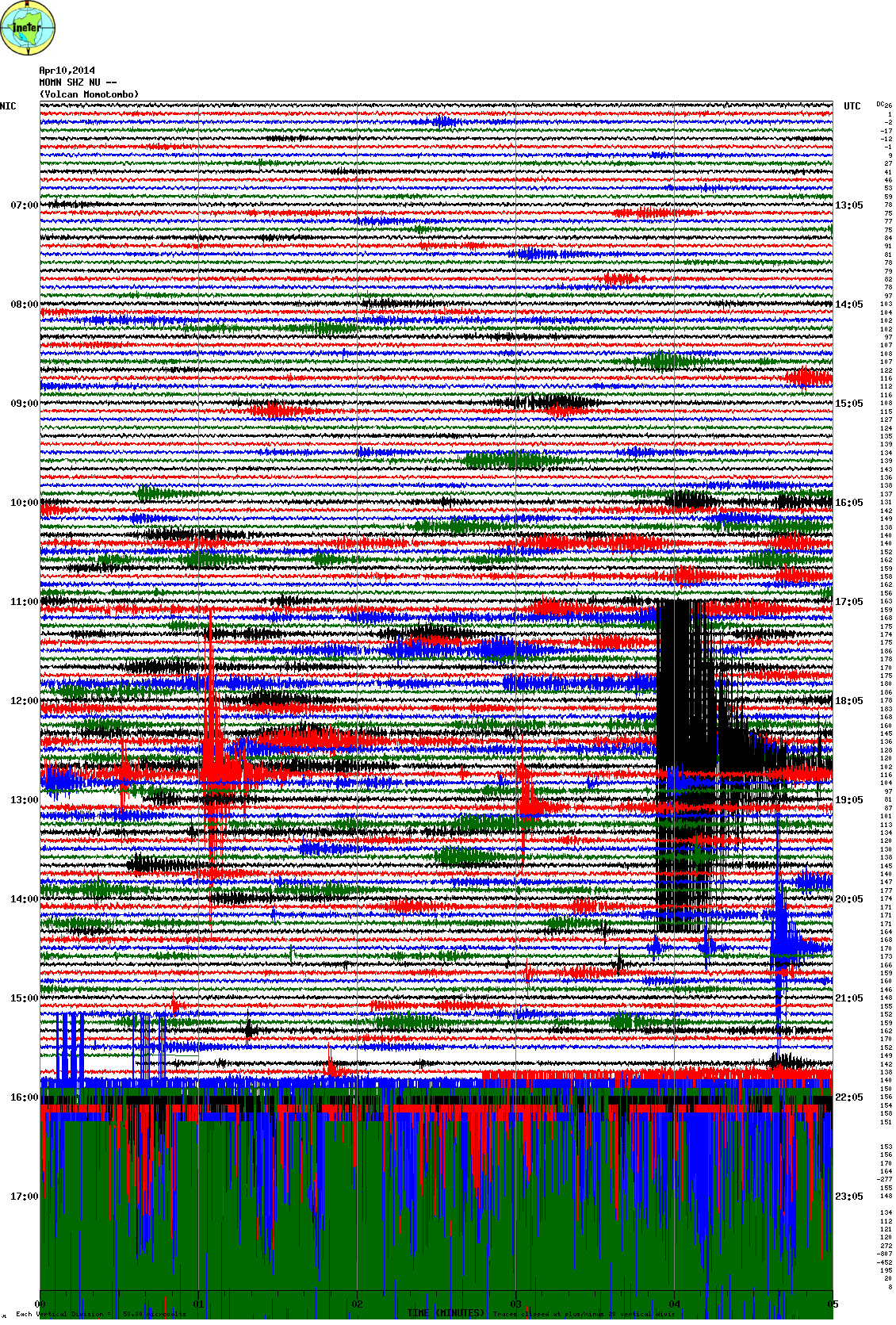
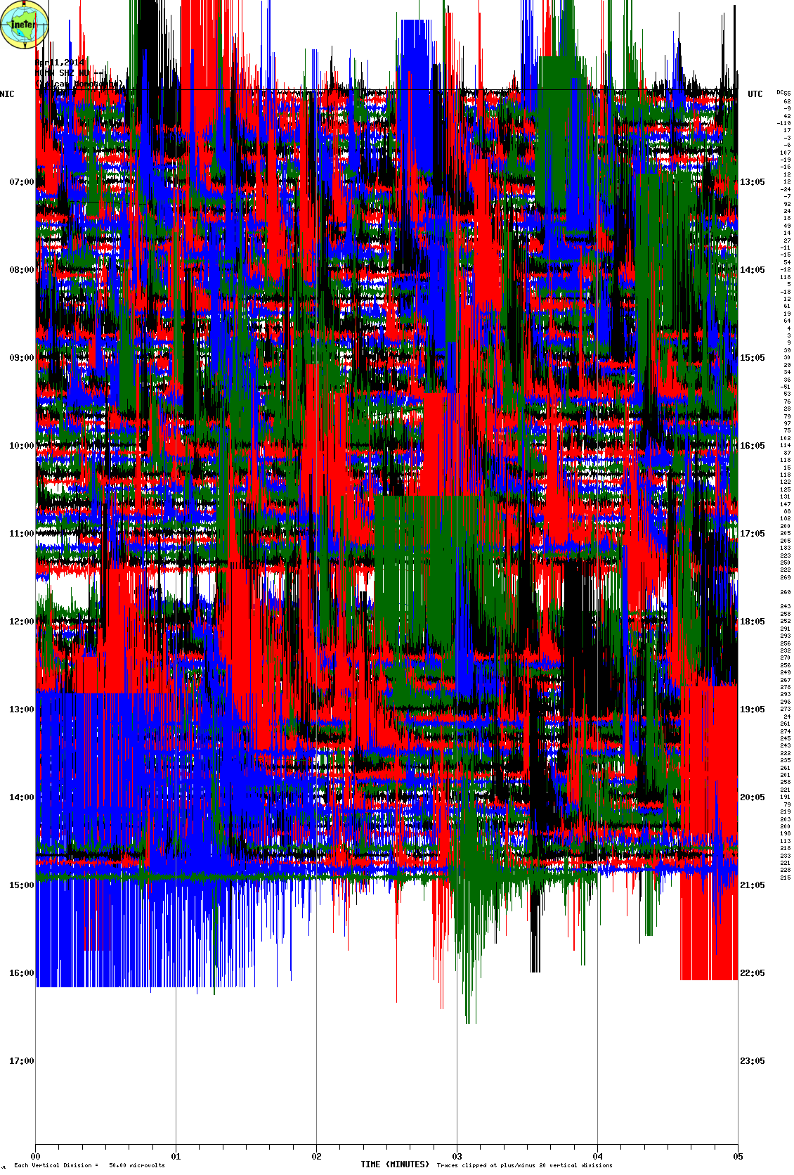
Now for some fearmongering. I think the most important earthquake to observe from this cluster of larger quakes is the smallest. Nicaragua. This was a shallow earthquake and right near a sleeping volcano. The aftershocks are many and - well, I checked the web-seismos and it makes me wonder about moving magma. Since I haven`t monitored these graphs I can`t tell if there`s any tremor of if it`s all aftershocks. Maybe there`s another format for them. I`ll post them and you`ll see how vigorous was the activity. I could be blowing it out of proportion, because of the volcano. And the big giant lake sitting above and right near a magma chamber.
Sorry for the big box but I want you to see the build up and some normal noise, and then the graph is overwhelmed.
I`ll be back and post the pics.
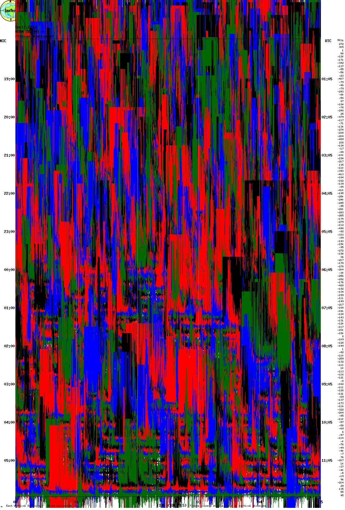
I`m not sure whether or not the second one is stuck. After a big quake they can develop a problem.
This next pic is when a giant fly was seen over Ubinas.
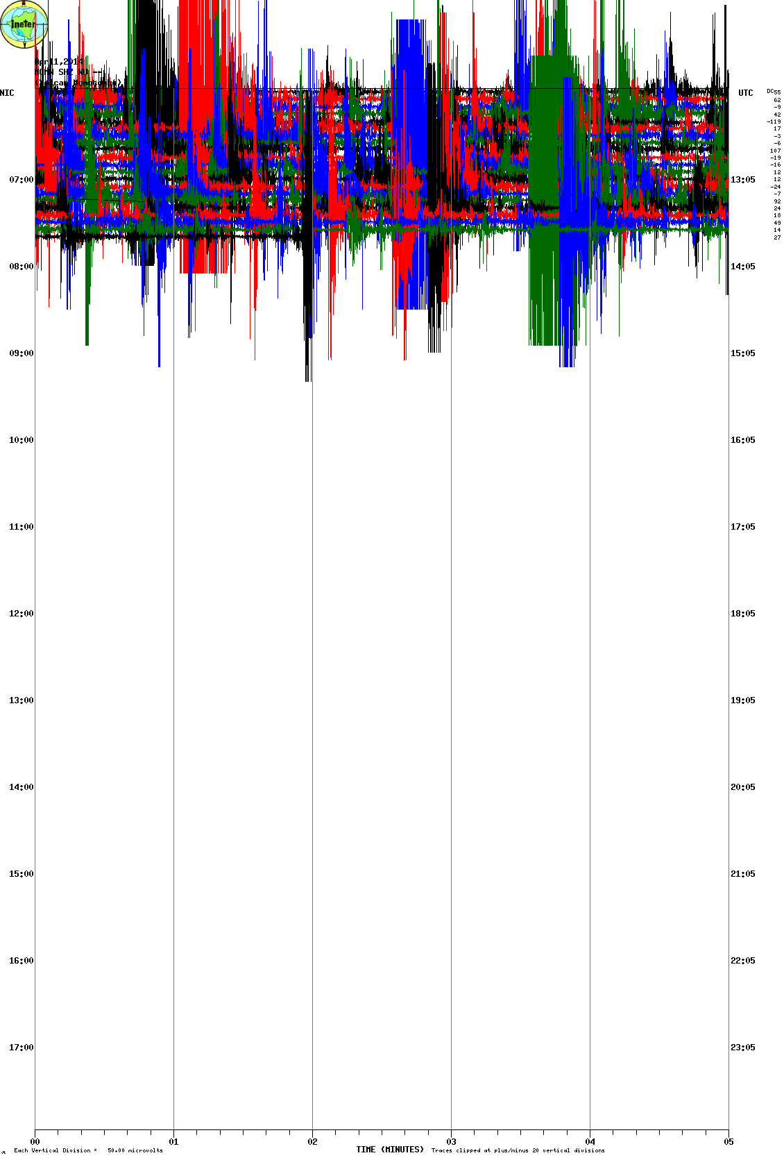
Having taken a second look, I don`t think it`s tremor. But it was constant earthquakes and I`m going to say they resemble Yellowstone`s and we got fluid earthquakes. I think magma.
Here`s a report from Volcano Discovery.
www.volcanodiscovery.com...
Oops. I didn`t fearmonger much. These earthquakes in Nicaragua could mean little to almost nothing overall. OR, DO theyÉ(that`s supposed to be a question mark- my keyboard is messed upÉ ) If you want to give yourself a fright, look at the eruptive history. It seems like it might be overdue for an eruption. There is an historical record reaching back many hundreds of years. If Central America is being pushed by the same forces that are at work in Chile, this little strip of land may crack and what oozes out of cracksÉ As my young son would say, `stuff``. Oh, that reminds me. That Idaho earthquake makes me think to watch Yellowstone over the next couple of days. If we get some swarms, it will be interesting to track locations.
Maybe I`m just scaring myself. For entertainment purposes. Maybe I should just ignore that big body of water of that big body of magma. Did you know that water+magma=phreatic explosions. And, in the eruptive history of Momotombo, they list explosive eruption potential.
If you read the past news for the volcano, you will see that there is discussion of possible magma intrusions during other swarms. The volcano was listed as restless. Restlessly sleeping. Now, I think it may have just awoken. Let`s just hope it was just having a nightmare and will quiet down. On the seismo it appears to be ebbing. When I was reading past news on the volcano I saw the other seismos in regards to past swarms. They don`t look very impressive when compared to today`s activity. Again, I don`t think there`s volcanic tremor, but it sure looks like the volcano`s reservoir is filling.
I should add that Ubinas is active at the moment.
Now for some fearmongering. I think the most important earthquake to observe from this cluster of larger quakes is the smallest. Nicaragua. This was a shallow earthquake and right near a sleeping volcano. The aftershocks are many and - well, I checked the web-seismos and it makes me wonder about moving magma. Since I haven`t monitored these graphs I can`t tell if there`s any tremor of if it`s all aftershocks. Maybe there`s another format for them. I`ll post them and you`ll see how vigorous was the activity. I could be blowing it out of proportion, because of the volcano. And the big giant lake sitting above and right near a magma chamber.
Sorry for the big box but I want you to see the build up and some normal noise, and then the graph is overwhelmed.
I`ll be back and post the pics.
I`m not sure whether or not the second one is stuck. After a big quake they can develop a problem.
This next pic is when a giant fly was seen over Ubinas.
edit on 11-4-2014 by ericblair4891 because: (no reason given)
Having taken a second look, I don`t think it`s tremor. But it was constant earthquakes and I`m going to say they resemble Yellowstone`s and we got fluid earthquakes. I think magma.
Here`s a report from Volcano Discovery.
www.volcanodiscovery.com...
Oops. I didn`t fearmonger much. These earthquakes in Nicaragua could mean little to almost nothing overall. OR, DO theyÉ(that`s supposed to be a question mark- my keyboard is messed upÉ ) If you want to give yourself a fright, look at the eruptive history. It seems like it might be overdue for an eruption. There is an historical record reaching back many hundreds of years. If Central America is being pushed by the same forces that are at work in Chile, this little strip of land may crack and what oozes out of cracksÉ As my young son would say, `stuff``. Oh, that reminds me. That Idaho earthquake makes me think to watch Yellowstone over the next couple of days. If we get some swarms, it will be interesting to track locations.
Maybe I`m just scaring myself. For entertainment purposes. Maybe I should just ignore that big body of water of that big body of magma. Did you know that water+magma=phreatic explosions. And, in the eruptive history of Momotombo, they list explosive eruption potential.
If you read the past news for the volcano, you will see that there is discussion of possible magma intrusions during other swarms. The volcano was listed as restless. Restlessly sleeping. Now, I think it may have just awoken. Let`s just hope it was just having a nightmare and will quiet down. On the seismo it appears to be ebbing. When I was reading past news on the volcano I saw the other seismos in regards to past swarms. They don`t look very impressive when compared to today`s activity. Again, I don`t think there`s volcanic tremor, but it sure looks like the volcano`s reservoir is filling.
I should add that Ubinas is active at the moment.
edit on 11-4-2014 by ericblair4891 because: (no reason given)
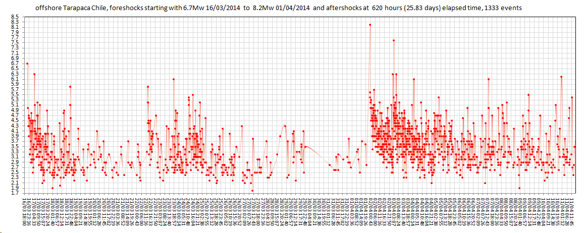
almost 26 days (620hrs) since the Tarapaca series started, almost 10 days since the 8.2Mw.
1332 events, 778 aftershocks since the 8.2, 553 events between the 6.7 and the 8.2
mag2=375, mag3=635, mag4=263, mag5= 48, mag6=8, mag7=1, mag8=1
total radiated energy released=34,358,531.6 TTNT
Catalog Source: Servicio Sismológico Universidad de Chile
 (click
image for larger version, opens in new tab/window)
(click
image for larger version, opens in new tab/window)
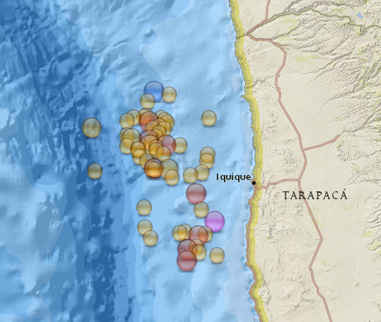
this is a map of the 5+ events. Blue =M8.2, Big Pink=M7.7, Big Red=M6s, Big Orange 5.6+, Orange >5.6
1332 events, 778 aftershocks since the 8.2, 553 events between the 6.7 and the 8.2
mag2=375, mag3=635, mag4=263, mag5= 48, mag6=8, mag7=1, mag8=1
total radiated energy released=34,358,531.6 TTNT
Catalog Source: Servicio Sismológico Universidad de Chile

this is a map of the 5+ events. Blue =M8.2, Big Pink=M7.7, Big Red=M6s, Big Orange 5.6+, Orange >5.6
edit on 0400000010010014 by muzzy because: damn i just noticed i used that graph template with the gap on the 30th
again, will redo it later
M6.6 - 11km ESE of Nandaime, Nicaragua
Event Time
2014-04-11 20:29:15 UTC
2014-04-11 14:29:15 UTC-06:00 at epicenter
Event Time
2014-04-11 20:29:15 UTC
2014-04-11 14:29:15 UTC-06:00 at epicenter
edit on 11-4-2014 by intergalactic fire because: wrong link inserted
earthquake.usgs.gov...
Nicaragua has had another at 6.6M. This one was deep. So, what's up? My question marks are back. Ahhhh.
I caught a pic of Nicaraqua before it gets overlapped by following quakes.
Nicaragua has had another at 6.6M. This one was deep. So, what's up? My question marks are back. Ahhhh.
I caught a pic of Nicaraqua before it gets overlapped by following quakes.
edit on 11-4-2014 by ericblair4891 because: (no reason given)
reply to post by ericblair4891
www.emsc-csem.org...
30 sec, some say 40 sec, is this long or pretty normal?
What are the causes for the duration of an earthquake?
I was just reading up on some info about lake Nicaragua (close to where the recent EQ's occured)
Could these quakes be a sign of an upcoming eruption at the concepcion volcano, located in the middle of the lake?
www.emsc-csem.org...
This one was quite long, it lasted about 20-30 seconds and came in waves. Managua is becoming quite dangerous, people are panicking
30 sec, some say 40 sec, is this long or pretty normal?
What are the causes for the duration of an earthquake?
I was just reading up on some info about lake Nicaragua (close to where the recent EQ's occured)
Could these quakes be a sign of an upcoming eruption at the concepcion volcano, located in the middle of the lake?
edit on 11-4-2014 by intergalactic fire because: (no reason given)
edit on 11-4-2014 by intergalactic fire because: (no reason
given)
Hey guys do any of you know any good android earthquake apps?
My gf has family in Puerto Rico and Costa Rica and the app I have now is on a two hour plus delay which is useless. Thanks ahead of time.
My gf has family in Puerto Rico and Costa Rica and the app I have now is on a two hour plus delay which is useless. Thanks ahead of time.
edit
on 04pm94u041188 by magnum1188 because: Damn auto correct
reply to post by intergalactic fire
I don't have much time at the moment. Hopefully, Muzzy and Puterman can answer question on duration, etc.
I'll just comment on Volcanoes. Yes, we should keep an eye on Nicaragua. Also, Fuego is becoming more active. So, all of Central America is something to watch.
Also active..
www.volcanodiscovery.com...
I found a second to write more. It seems another Central American Volcano, San Cristobal is active. Also, Tan
www.volcanodiscovery.com...
Tan
www.volcanodiscovery.com...
I think there is a great chance the Nicaraguan earthquake are driving the volcanoes activity.
edit on 12-4-2014 by ericblair4891 because: (no reason given)
reply to post by PuterMan
Seems to me, Master Quake Jockey . . . that your predictive hunches were spot on yet again in terms of the So Seas region.
Congrats.
Given all that's gone on the past 30 days . . . Any more hunches for the next 30 days?
Seems to me, Master Quake Jockey . . . that your predictive hunches were spot on yet again in terms of the So Seas region.
Congrats.
Given all that's gone on the past 30 days . . . Any more hunches for the next 30 days?
reply to post by magnum1188
I use this Quake App... you can config it to what magnitude to warn you and make a sound alert too.. and an icon appears in the top left on my Samsung Galaxy Tab 10...
play.google.com...
Once you download it, make sure you update it they say, since the USGS updated the way they handle data now.
Check out the others too.. just do a search on Google Play shop... we weary of cheap looking ones... read reviews and stuff... you know the drill I'm sure .
(ugh... just found out, this app only covers the USA... they say in 'a future release' they will add the worlds quakes'.. bah.. ) overlooked that due to I'm usually on the PC checking the USGS
edit on 4/12/2014 by Pharyax because: (no reason given)
magnum1188
Hey guys do any of you know any good android earthquake apps?
My gf has family in Puerto Rico and Costa Rica and the app I have now is on a two hour plus delay which is useless. Thanks ahead of time.edit on 04pm94u041188 by magnum1188 because: Damn auto correct
I've made a very simple app for my home state of Oklahoma, specifically. I have this issue with my app as well - small earthquakes are just not automatically detected by the computer networks monitoring seismic stations. Below a 2.5M, it is often not recognized as an earthquake by computers. Seismologists monitoring the feeds can manually designate an earthquake, and this can cause some delay in reporting - sometimes days, in my experience.
The monitoring network also operates on a small delay, where it periodically polls the seismograph stations for updates. What I can suggest for now is this website: rev.seis.sc.edu.... Personally, I'm researching how to get/use the data from the stations directly.
Thanks for that info guys. I have recently gotten rid of both my internet and cable television so the only thing I have keeping me updated is my
android phone. All of the apps that I have gotten to date are either extremely late in the quake reporting (more than an hour) or they just leave
certain ones out.
M7.6 - 100km SSE of Kirakira, Solomon Islands
2014-04-12 20:14:39 UTC
Event Time
2014-04-12 20:14:39 UTC
2014-04-13 07:14:39 UTC+11:00 at epicenter
2014-04-12 15:14:39 UTC-05:00 system time
Location
11.315°S 162.211°E depth=29.3km (18.2mi)
Nearby Cities
100km (62mi) SSE of Kirakira, Solomon Islands
323km (201mi) SE of Honiara, Solomon Islands
711km (442mi) NW of Luganville, Vanuatu
925km (575mi) SE of Arawa, Papua New Guinea
968km (601mi) NW of Port-Vila, Vanuatu
USGS
edit on 12-4-2014 by lurksoften because: revised down from
a 8.3
new topics
-
BIDEN Admin Begins Planning For January 2025 Transition to a New President - Today is 4.26.2024.
2024 Elections: 18 minutes ago -
Big Storms
Fragile Earth: 1 hours ago -
Where should Trump hold his next rally
2024 Elections: 4 hours ago -
Shocking Number of Voters are Open to Committing Election Fraud
US Political Madness: 5 hours ago -
Gov Kristi Noem Shot and Killed "Less Than Worthless Dog" and a 'Smelly Goat
2024 Elections: 5 hours ago -
Falkville Robot-Man
Aliens and UFOs: 6 hours ago -
James O’Keefe: I have evidence that exposes the CIA, and it’s on camera.
Whistle Blowers and Leaked Documents: 6 hours ago -
Australian PM says the quiet part out loud - "free speech is a threat to democratic dicourse"...?!
New World Order: 7 hours ago -
Ireland VS Globalists
Social Issues and Civil Unrest: 8 hours ago -
Biden "Happy To Debate Trump"
2024 Elections: 8 hours ago
top topics
-
James O’Keefe: I have evidence that exposes the CIA, and it’s on camera.
Whistle Blowers and Leaked Documents: 6 hours ago, 13 flags -
Blast from the past: ATS Review Podcast, 2006: With All Three Amigos
Member PODcasts: 10 hours ago, 13 flags -
Australian PM says the quiet part out loud - "free speech is a threat to democratic dicourse"...?!
New World Order: 7 hours ago, 12 flags -
Biden "Happy To Debate Trump"
2024 Elections: 8 hours ago, 12 flags -
Mike Pinder The Moody Blues R.I.P.
Music: 11 hours ago, 8 flags -
What is the white pill?
Philosophy and Metaphysics: 10 hours ago, 6 flags -
Shocking Number of Voters are Open to Committing Election Fraud
US Political Madness: 5 hours ago, 6 flags -
RAAF airbase in Roswell, New Mexico is on fire
Aliens and UFOs: 8 hours ago, 5 flags -
Ireland VS Globalists
Social Issues and Civil Unrest: 8 hours ago, 5 flags -
Where should Trump hold his next rally
2024 Elections: 4 hours ago, 4 flags
active topics
-
Krystalnacht on today's most elite Universities?
Social Issues and Civil Unrest • 12 • : TheSingleBillie -
Gaza Terrorists Attack US Humanitarian Pier During Construction
Middle East Issues • 90 • : Zanti Misfit -
Gov Kristi Noem Shot and Killed "Less Than Worthless Dog" and a 'Smelly Goat
2024 Elections • 39 • : Zanti Misfit -
So this is what Hamas considers 'freedom fighting' ...
War On Terrorism • 268 • : TheWoker -
BIDEN Admin Begins Planning For January 2025 Transition to a New President - Today is 4.26.2024.
2024 Elections • 2 • : NoCorruptionAllowed -
Falkville Robot-Man
Aliens and UFOs • 7 • : KKLOCO -
Big Storms
Fragile Earth • 9 • : nerbot -
"We're All Hamas" Heard at Columbia University Protests
Social Issues and Civil Unrest • 294 • : TheWoker -
Where should Trump hold his next rally
2024 Elections • 15 • : Zanti Misfit -
Post A Funny (T&C Friendly) Pic Part IV: The LOL awakens!
General Chit Chat • 7138 • : baddmove