It looks like you're using an Ad Blocker.
Please white-list or disable AboveTopSecret.com in your ad-blocking tool.
Thank you.
Some features of ATS will be disabled while you continue to use an ad-blocker.

Quake Watch 2014
page: 50share:
reply to post by BO XIAN
I think fracturing apart is the more likely scenerio
Maybe a big one due for Fiordland, NZ, been a couple of M4s there in the last few days, has been pretty quiet since 16/02/2014. Christchurch had a 4.2 yesterday as well NZST, so things are moving again down south after a quiet spell.
I think fracturing apart is the more likely scenerio
Maybe a big one due for Fiordland, NZ, been a couple of M4s there in the last few days, has been pretty quiet since 16/02/2014. Christchurch had a 4.2 yesterday as well NZST, so things are moving again down south after a quiet spell.
reply to post by BlackPhoenix
There's a map key at the bottom of the page it tells you what the markers mean. Apparently it means 'tsunami station in event mode (with in previous 24 hours)'
I have no idea what it means
There's a map key at the bottom of the page it tells you what the markers mean. Apparently it means 'tsunami station in event mode (with in previous 24 hours)'
I have no idea what it means
muzzy
reply to post by Nyiah
so how long have the USGS heliplots been back up?
guess I missed the memo
So did I, and thank you Nyiah for bringing it to our attention.
I have spent some time this afternoon getting them back into the QVSData program. More on that later.
M3.7 - 11km SSW of Guthrie, Oklahoma 2014-04-13 20:02:21 UTC
USGS
I drove through Oklahoma about 3 years ago and got so creeped out going through Oklahoma City because I kept thinking about a big earthquake there. My brother told me to shut up because we were right in the middle of the city on the freeway, bad place for a big EQ. So my question is to the EQ experts...
All of these earthquakes there, is no one worried about a major earthquake?
What is the biggest in that area?
Why is the ground shaking so much in this area?
Is it really frakking?
I just don't buy that.
edit on 13-4-2014 by Darkblade71 because: (no reason given)
reply to post by Darkblade71
I can't find it right now, but there have been studies that have shown a uptick in EQ activity since the fracking began in earnest. Ohio just put some serious crimps on the fracking industry because there were multiple EQ's happening where none had happened before.
Ah, here they are.
www.latimes.com...
www.usatoday.com...
www.bloomberg.com...
Many more out there
edit on 13-4-2014 by TDawgRex because: Just a ETA
Oklahoma is not known at all for strong earthquakes, but that's only in recent history. We've had only two confirmed 5+ magnitude earthquakes since
statehood.
What we do know is that there were some prior to Oklahoma becoming a state - the earliest recorded one that I know of was reported by Fort Gibson, which is in east central Oklahoma. This may have been in the 5-7+ range, depending on how far away it was. We don't really know, but I recall reading in an old book that it was 7+.
From the geological record, there's the Meers fault, near the Wichita Mountains - far to the south and west of current activity (over 150km). It's the only visible fault from the air. Estimates of that put its last major earthquake at 1300 years ago with a strength of between 6.5 and 7 magnitude.
A funny thing - if you look at this last link, it also lists 14 historic earthquakes (4.0+ magnitude). We've had half that many in the last month: 4.0M on 3/21, 4.1M and 2 4.3M on 3/30, 4.2M on 4/6, 4.2M on 4/7, and 4.1M on 4/10. According to one scientist, we've had 13 4.0+ M prior to 2010, 20 4.0+ M since 2010, and 7 of them were in the last month.
edit on 18Sun, 13 Apr 2014 18:17:16 -0500America/ChicagovAmerica/Chicago4 by Greven
because: (no reason given)
Darkblade71
M3.7 - 11km SSW of Guthrie, Oklahoma 2014-04-13 20:02:21 UTC
USGS
I drove through Oklahoma about 3 years ago and got so creeped out going through Oklahoma City because I kept thinking about a big earthquake there. My brother told me to shut up because we were right in the middle of the city on the freeway, bad place for a big EQ. So my question is to the EQ experts...
All of these earthquakes there, is no one worried about a major earthquake?
What is the biggest in that area?
Why is the ground shaking so much in this area?
Is it really frakking?
I just don't buy that.
edit on 13-4-2014 by Darkblade71 because: (no reason given)
Sound like all those earthquake have a good reason being
maybe a new volcanoes
www.examiner.com...
Oklahoma Earthquakes
Southern Oklahoman Aulacogen & Mid Continent Rift Connection?
Links:
Definition of Aulacogen: en.wikipedia.org...
Big tectonic events that affected Oklahoma & surrounding areas: www.ogs.ou.edu...
Very interesting info on Oklahoma Geology (All pages) but I was struck by Page 19 due to it showing the mid-continent rift running through southern Kansas & Northern OK and not following the Mississippi River as shown on a lot of maps. It also looks to run where some of these recent earthquakes have been happening. (Yes I know the fracking may have something or a lot to do with these but what about the underlying geology could it be...) Any thoughts ATS geology seekers?
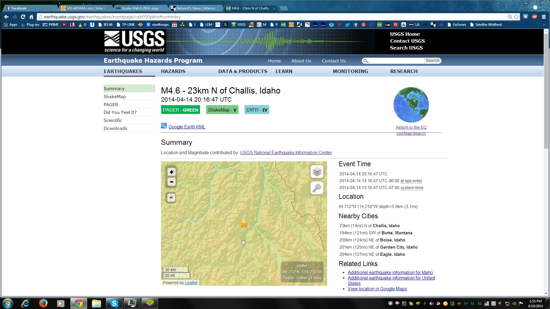
earthquake.usgs.gov...
M4.6 - 23km N of Challis, Idaho
2014-04-14 20:16:47 UTC
Event Time
2014-04-14 20:16:47 UTC
2014-04-14 14:16:47 UTC-06:00 at epicenter
2014-04-14 13:16:47 UTC-07:00 system time
Location
44.712°N 114.218°W depth=5.0km (3.1mi)
Nearby Cities
23km (14mi) N of Challis, Idaho
194km (121mi) SW of Butte, Montana
200km (124mi) NE of Boise, Idaho
201km (125mi) NE of Garden City, Idaho
204km (127mi) NE of Eagle, Idaho
files.abovetopsecret.com...

files.abovetopsecret.com...
M4.6 - 23km N of Challis, Idaho
2014-04-14 20:16:47 UTC
Event Time
2014-04-14 20:16:47 UTC
2014-04-14 14:16:47 UTC-06:00 at epicenter
2014-04-14 13:16:47 UTC-07:00 system time
Location
44.712°N 114.218°W depth=5.0km (3.1mi)
Nearby Cities
23km (14mi) N of Challis, Idaho
194km (121mi) SW of Butte, Montana
200km (124mi) NE of Boise, Idaho
201km (125mi) NE of Garden City, Idaho
204km (127mi) NE of Eagle, Idaho
files.abovetopsecret.com...
files.abovetopsecret.com...
edit on 7/30/2012 by dreamfox1 because: 
Usgs just erased the 2.9 Montana quake off the list
Its just plain stupid when the whole world can see what they are hiding
Its just plain stupid when the whole world can see what they are hiding
reply to post by dreamfox1
I'm feeling dumb, what are they hiding and who is they?
Oh and before I forget, Thanks everyone on the Info on Oklahoma.
I'm feeling dumb, what are they hiding and who is they?
Oh and before I forget, Thanks everyone on the Info on Oklahoma.
edit on 14-4-2014 by Darkblade71 because: (no reason given)
Darkblade71
reply to post by dreamfox1
I'm feeling dumb, what are they hiding and who is they?
Oh and before I forget, Thanks everyone on the Info on Oklahoma.edit on 14-4-2014 by Darkblade71 because: (no reason given)
They are none other than the USGS and the Gov telling them to do so. Hiding high priory quakes and events from the public to avoid panic.
edit
on 7/30/2012 by dreamfox1 because: (no reason given)
dreamfox1
Darkblade71
reply to post by dreamfox1
I'm feeling dumb, what are they hiding and who is they?
Oh and before I forget, Thanks everyone on the Info on Oklahoma.edit on 14-4-2014 by Darkblade71 because: (no reason given)
They are none other than the USGS and the Gov telling them to do so. Hiding high priory quakes and events from the public to avoid panic.edit on 7/30/2012 by dreamfox1 because: (no reason given)
Ok now I feel dumb and I apologize in advance if it offends but how can a low magnitude quake in Montana cause fear in people and need to be hidden. Does it have something to do with yellow stone?
batcrapcrazy
dreamfox1
Darkblade71
reply to post by dreamfox1
I'm feeling dumb, what are they hiding and who is they?
Oh and before I forget, Thanks everyone on the Info on Oklahoma.edit on 14-4-2014 by Darkblade71 because: (no reason given)
They are none other than the USGS and the Gov telling them to do so. Hiding high priory quakes and events from the public to avoid panic.edit on 7/30/2012 by dreamfox1 because: (no reason given)
Ok now I feel dumb and I apologize in advance if it offends but how can a low magnitude quake in Montana cause fear in people and need to be hidden. Does it have something to do with yellow stone?
You hit the nail on the head yes it does.
reply to post by dreamfox1
Is it possible that it was just an echo from another quake, and they adjusted it because of that? I have seen that happen before.
Is it possible that it was just an echo from another quake, and they adjusted it because of that? I have seen that happen before.
Yes there seems to be a little cluster of quakes going on in Central Idaho Since the 10th of April on USGS anyway 4.9 to 5.0 km deep and 4.1; 4.9 and
now 4.4 downgraded from 4.6 with little ones in between.
4.4
16km NNW of Challis, Idaho
2014-04-14 16:16:46 UTC-04:005.0 km
3.0
19km NNW of Challis, Idaho
2014-04-14 14:58:37 UTC-04:005.0 km
2.6
10km NNW of Challis, Idaho
2014-04-13 07:21:08 UTC-04:005.0 km
2.6
22km N of Challis, Idaho
2014-04-12 21:48:51 UTC-04:005.0 km
3.2
12km NW of Challis, Idaho
2014-04-12 20:23:50 UTC-04:004.9 km
4.9
15km N of Challis, Idaho
2014-04-12 20:04:41 UTC-04:005.0 km
3.1
16km NNW of Challis, Idaho
2014-04-12 09:06:20 UTC-04:005.0 km
2.5
19km NNW of Challis, Idaho
2014-04-11 10:19:01 UTC-04:005.0 km
4.1
15km NNW of Challis, Idaho
2014-04-10 08:21:34 UTC-04:005.0 km
bhs.idaho.gov
The last large earthquakes in this area was a 7.3 in 1959 followed by a 6.9 in 1983. These earthquakes caused surface rupture, landslides and numerous aftershocks. In 1959 the Hebgen quake set off land slides and rock falls and effected the man made Hebgen dam which was over-topped by high waves and narrowly survived. The 1983 Borah Peak earthquake (6.9) was felt in Montana, Nevada, Oregon, Washington, British Columbia, Alberta and Saskatchewan.
Are these rumblings stirring this fault or something bigger or are these still aftershocks of the above quakes?
Event Time
2014-04-15 03:57:02 UTC
2014-04-15 04:57:02 UTC+01:00 at epicenter
2014-04-14 23:57:02 UTC-04:00 system time
Location
53.527°S 8.704°E depth=11.7km (7.3mi)
Nearby Cities
364km (226mi) ENE of Bouvet Island, Bouvet Island
2279km (1416mi) SSW of Hermanus, South Africa
2291km (1424mi) SSW of Bredasdorp, South Africa
2301km (1430mi) SSW of Grabouw, South Africa
3092km (1921mi) SSW of Maseru, Lesotho
Bouvet Island Region
reply to post by muzzy
If you are trying to find it, it is nowhere near South Africa. Fine the southern tip of the African Continent and look down, half way to Antarctica, yes, right down there.
Why does the description not say "Ocean between Africa and Antarctica" It would be much more realistic and sensible but, oh well! Maybe it says a lot about the accuracy of professional seismologists, ie, not very professional!
I know, it has been said before. MAYBE THEY SHOULD GET THERE COLLECTIVE BUTTS INTO GEAR AND CHANGE IT!!!!!
Sometimes, you just need to scream a little.
IT IS BLOODY WELL NOT GOOD ENOUGH YOU THICK CLUNKS!
Now I feel better!
P
edit on 15/4/2014 by pheonix358 because: (no reason given)
new topics
-
Pentagon acknowledges secret UFO project, the Kona Blue program | Vargas Reports
Aliens and UFOs: 31 minutes ago -
Boston Dynamics say Farewell to Atlas
Science & Technology: 39 minutes ago -
I hate dreaming
Rant: 1 hours ago -
Is the origin for the Eye of Horus the pineal gland?
Philosophy and Metaphysics: 3 hours ago -
Man sets himself on fire outside Donald Trump trial
Mainstream News: 3 hours ago -
Biden says little kids flip him the bird all the time.
2024 Elections: 3 hours ago -
The Democrats Take Control the House - Look what happened while you were sleeping
US Political Madness: 3 hours ago -
Sheetz facing racial discrimination lawsuit for considering criminal history in hiring
Social Issues and Civil Unrest: 4 hours ago -
In an Historic First, In N Out Burger Permanently Closes a Location
Mainstream News: 5 hours ago -
MH370 Again....
Disaster Conspiracies: 6 hours ago
top topics
-
In an Historic First, In N Out Burger Permanently Closes a Location
Mainstream News: 5 hours ago, 14 flags -
The Democrats Take Control the House - Look what happened while you were sleeping
US Political Madness: 3 hours ago, 10 flags -
Thousands Of Young Ukrainian Men Trying To Flee The Country To Avoid Conscription And The War
Other Current Events: 16 hours ago, 8 flags -
A man of the people
Medical Issues & Conspiracies: 11 hours ago, 8 flags -
Man sets himself on fire outside Donald Trump trial
Mainstream News: 3 hours ago, 7 flags -
Biden says little kids flip him the bird all the time.
2024 Elections: 3 hours ago, 6 flags -
4 plans of US elites to defeat Russia
New World Order: 13 hours ago, 4 flags -
Is the origin for the Eye of Horus the pineal gland?
Philosophy and Metaphysics: 3 hours ago, 4 flags -
Sheetz facing racial discrimination lawsuit for considering criminal history in hiring
Social Issues and Civil Unrest: 4 hours ago, 3 flags -
Are you ready for the return of Jesus Christ? Have you been cleansed by His blood?
Religion, Faith, And Theology: 8 hours ago, 3 flags
active topics
-
In an Historic First, In N Out Burger Permanently Closes a Location
Mainstream News • 8 • : KrustyKrab -
12 jurors selected in Trump criminal trial
US Political Madness • 104 • : Annee -
Russian intelligence officer: explosions at defense factories in the USA and Wales may be sabotage
Weaponry • 175 • : Freeborn -
Thousands Of Young Ukrainian Men Trying To Flee The Country To Avoid Conscription And The War
Other Current Events • 36 • : Xtrozero -
Fossils in Greece Suggest Human Ancestors Evolved in Europe, Not Africa
Origins and Creationism • 77 • : Consvoli -
Are you ready for the return of Jesus Christ? Have you been cleansed by His blood?
Religion, Faith, And Theology • 19 • : glend -
I hate dreaming
Rant • 4 • : Macenroe1982 -
The Democrats Take Control the House - Look what happened while you were sleeping
US Political Madness • 34 • : DBCowboy -
Do we live in a simulation similar to The Matrix 1999?
ATS Skunk Works • 28 • : JoelSnape -
Old School Punk
Music • 537 • : underpass61