It looks like you're using an Ad Blocker.
Please white-list or disable AboveTopSecret.com in your ad-blocking tool.
Thank you.
Some features of ATS will be disabled while you continue to use an ad-blocker.

Quake Watch 2014
page: 13&mem=share:
Good to hear you and your family are O.K..
I have been watching that storm that your having now. It's looks nasty.
Stay safe and dry.
Peace.
Crappiekat
I have been watching that storm that your having now. It's looks nasty.
Stay safe and dry.
Peace.
Crappiekat
Hey Muzzy, I'm so happy to hear you and Mrs. Muzzy are fine--great news. You crack me up--no stinking Mag 6.2 is going to stop you from getting a
job done--I love it.
Nyiah posted a link to a Stuff.nz article that had this unpleasant news about the CastleRock rockfall:
Does GeoNet work up focal mechanisms for their quakes? Because of it's location, I would have thought this was possibly subduction related, but USGS shows normal-style faulting?
Keep calm and finish the roofing...
Nyiah posted a link to a Stuff.nz article that had this unpleasant news about the CastleRock rockfall:
The jolt also loosened a massive chunk of rock from the 162m high Castle Rock. Castlepoint Station manager Anders Crofoot said the boulder was ''sizeable, maybe 20 tonnes.''
Castlepoint Store owner Devon Oakley said although some people had a few things knocked off shelves the township was much the same as before.He said the chunk was ''about the size of a bulldozer", but Castle Rock was still standing.
Masterton man William Alexander said the rockfall, which fell from the cliff ridge, killed about nine seals including at least two pups.
Does GeoNet work up focal mechanisms for their quakes? Because of it's location, I would have thought this was possibly subduction related, but USGS shows normal-style faulting?
Keep calm and finish the roofing...
reply to post by muzzy
Muzzy, good to know you and yours are safe and well. Many were concerned.
One day when you get time with nothing to do, could you list all of the little thing you do to prepare your home. The tidbits you gave were fascinating.
P
Muzzy, good to know you and yours are safe and well. Many were concerned.
One day when you get time with nothing to do, could you list all of the little thing you do to prepare your home. The tidbits you gave were fascinating.
P
35 mins ago
Public Id: 2014p054100
NZDT: Tuesday, January 21 2014 at 1:24:38 pm
Maximum intensity ?: moderate
Depth: 36 km
Magnitude: 4.5
Location: 15 km east of Eketahuna
37 mins ago
Public Id: 2014p054096
NZDT: Tuesday, January 21 2014 at 1:22:35 pm
Maximum intensity ?: moderate
Depth: 20 km
Magnitude: 4.5
Location: 15 km east of Eketahuna
www.geonet.org.nz...
reply to post by pheonix358
After the M6.2 last year and the contents of our Pantry spilled on the floor, I got some white plastic strip 80mm x1mm (3"x.1/8") and screwed it to the front edge of each shelf. We keep pantry items to one layer high now too, so they don't fall over behind the shelf lip.
All our wall pictures/paintings have 2 hooks.
Small nick-nacks in the lounge and dining room are stuck to the shelf with "museum wax" (you can google that)
All high cabinets or bookshelves are fixed to the wall with a metal L shaped bracket and 2 screws, so they don't tip over.
(I had just fitted one of those to my Dad's antique nick-nack cabinet which has dozens of glass and pottery pieces in it a few weeks ago when he moved back here from Australia, it has a glass front (doors) and glass shelves and sits on 4 x 1ft high legs, as soon as I seen it I knew it needed a wall bracket!))
We generally keep stuff at floor level, such as big pots and vases.
As well as the basic EQ survival stuff like;
2 x 500x800x500mm plastic storage boxes filled with canned and dried food, radio, batteries, flashlight, candles, toiletries, prescription drugs etc, we keep in a cupboard right beside the front door. It pays to replenish this every 3 months ( which just happens to coincide with the earthquake events we have been having here the last few years)
3 x 20 litre containers of water, we keep covered just outside the back door. (probably should have more, but where do you stop? get your own 100 gal watertank?)
I also got myself a rechargeable battery thingy for my cell phone that you plug into your computer to charge, makes it easier to remember to keep it charged. Take it with you and its good for an extra day of phone useage.
reply to post by Olivine
They do do MT's, but it often takes a while.
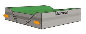
"Normal" could also apply to Thrust events I think, but in opposite directions
Basically its the ground going up and down or Dip-slip faults (versus Strike Slip)
Courtesy of USGS
Thrust
Normal
compared to Strike Slip (side to side)
They do do MT's, but it often takes a while.
"Normal" could also apply to Thrust events I think, but in opposite directions
Basically its the ground going up and down or Dip-slip faults (versus Strike Slip)
Courtesy of USGS
Thrust
Normal
compared to Strike Slip (side to side)
edit on 01000000191914 by muzzy because: (no reason given)
M 6.5 - 132km NW of Hihifo, Tonga
Time
2014-01-20 19:29:13 UTC-06:00
Location
15.140°S 174.661°W
Depth
33.0km
top of that fault line...
No Tsunami Warnings, Advisories or Watches are in effect
earthquake.usgs.gov...
downgraded stats:
M 5.9 - 159km WNW of Hihifo, Tonga
Time
2014-01-20 19:29:13 UTC-06:00
Location
15.250°S 175.051°W
Depth
10.0km
earthquake.usgs.gov...
Time
2014-01-20 19:29:13 UTC-06:00
Location
15.140°S 174.661°W
Depth
33.0km
top of that fault line...
No Tsunami Warnings, Advisories or Watches are in effect
earthquake.usgs.gov...
edit on 20-1-2014 by berkeleygal because: (no reason given)
downgraded stats:
M 5.9 - 159km WNW of Hihifo, Tonga
Time
2014-01-20 19:29:13 UTC-06:00
Location
15.250°S 175.051°W
Depth
10.0km
earthquake.usgs.gov...
edit on 20-1-2014 by berkeleygal because: (no reason given)
reply to post by muzzy
Nice list, thanks it was interesting.
One piece of advice if I may!
You have one or two cars. All cars have a big 12 volt battery in them. You can add a spare in the boot / trunk / whatever the area is that you put your shopping in. Batteries are not that expensive and if you put a spare in try and make it one designed for RVs.
You can get a cell phone charger for your car. You can run a laptop off a car. You can buy a TV for the car. You can run a small fridge for the car etc etc. You can buy small torches that have car rechargers.
The car is transport, it can also be a recharge centre for all your needs. Many torches and lots of other stuff is designed to run off 18650 li-ion batteries. If you can stick to one type of rechargeable battery, so much the better.
Looking up 'torch xml t6' on ebay will give a great many very bright, very small torches that take 18650 batteries and chargers for your car are available.
Sorry if I am preaching to the converted.
P
reply to post by pheonix358
No problem, some good ideas there.
Worst case scenerio for me is to be on the other side of the Coast when the M8.0 hits, bridges down, or landslides along the coast road, would have to leave the vehicle on the other side to be able to get through and to get home.
Lot depends on how bad things are, of course the vehicle stocked as you suggest would be a good staging point if could get near to the blockage, hang out for a while, then head off with the basic needs for a days hike home.
My brother, who is a keen mountainbiker suggested I carry a breakdown mountain bike in my van for such a case. However the odds of it coming to that are outweighed by the need for space for daily chores at work.
Same thing with water, I carry 20litres (5 gals) with me in the van, but I wouldn't be humping that over the hills on foot (unless it was worth its weight in Gold on the other side)
edit on 01000000191914 by muzzy because: (no reason given)
Latest data in for the 20th Jan 2014 New Zealand.
There was a big gap of no events for 21 hours, 33 minutes before the M6.2, in fact it was the first quake of the day at 2:52:00UTC on the 20th, and there was a 2 hour, 39 minute gap before the 1st aftershock! That seems quite unusual, I'll have to check some other NZ big events to see if this is "normal", otherwise it may have been a network breakdown???? or a coverup????
20/01/2014 NZ interactive map, in the comments below is a list of the Felt Reports set into categories. Geonet used to do this on their own site, but now they just show a map with a bunch of vague coloured icons on it showing e.g. weak-very strong, that is just laziness, or pandering to the i-phone generation who don't really care about details.
Edit:
The GSAIM Graph for 20/01/2014 shows the gap and the start of the aftershocks, dominating the Global activity for the day.
Very few quakes between 4.5 and 5.0 for the day (depends who you follow, I always take the highest reading for an event)
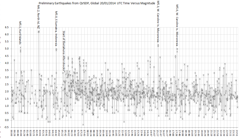 _____(click image for larger version, opens
in new tab/window)_______ sit back 3ft from your screen and you can see the trail of aftershocks
_____(click image for larger version, opens
in new tab/window)_______ sit back 3ft from your screen and you can see the trail of aftershocks
There was a big gap of no events for 21 hours, 33 minutes before the M6.2, in fact it was the first quake of the day at 2:52:00UTC on the 20th, and there was a 2 hour, 39 minute gap before the 1st aftershock! That seems quite unusual, I'll have to check some other NZ big events to see if this is "normal", otherwise it may have been a network breakdown???? or a coverup????
20/01/2014 NZ interactive map, in the comments below is a list of the Felt Reports set into categories. Geonet used to do this on their own site, but now they just show a map with a bunch of vague coloured icons on it showing e.g. weak-very strong, that is just laziness, or pandering to the i-phone generation who don't really care about details.
edit on
01000000191914 by muzzy because: (no reason given)
Edit:
The GSAIM Graph for 20/01/2014 shows the gap and the start of the aftershocks, dominating the Global activity for the day.
Very few quakes between 4.5 and 5.0 for the day (depends who you follow, I always take the highest reading for an event)

edit on 01u191914 by muzzy because: (no reason given)
edit on 01000000191914 by muzzy because: (no reason given)
reply to post by muzzy
There are sure a lot of trade off decisions in prepping for quakes etc.
You seem to have them scoped out pretty well.
BTW, Did you get the U2U?
There are sure a lot of trade off decisions in prepping for quakes etc.
You seem to have them scoped out pretty well.
BTW, Did you get the U2U?
delete mystifying double post
edit on 20/1/2014 by BO XIAN because: (no reason given)
muzzy
"Normal" could also apply to Thrust events I think, but in opposite directions
Basically its the ground going up and down or Dip-slip faults (versus Strike Slip)
I don't think so. Yes, both normal and thrust faulting have vertical movement, but thrust faulting is compressional and normal faulting is extensional (or tensional, if you prefer).
Normal-style faulting at depth, under so much pressure from the surrounding rock, has always seemed odd to me. I understand the mechanics of it under a volcano, and it makes good sense in a rifting environment, but at deeper depths--well I have a hard time wrapping my head around it.
I guess this Mag 6.2 was the result of your north Island being pulled apart deep below...really interesting.
stuff.co.nz
Last updated 05:00 22/01/2014
There is a one-in-four chance of a repeat of the earthquake that struck near Eketahuna, jangling nerves and causing widespread damage.
GNS duty seismologist Caroline Little said there was a 24 per cent probability of a quake between magnitude 6 and 6.9 in the region in the next 30 days.
"That's our best estimate based on worldwide data and what the aftershocks are doing at the moment."
There was a 3 per cent chance of a quake of magnitude 7 and over in the next 30 days.
edit on 01u202014 by muzzy
because: (no reason given)
reply to post by Olivine
I don't think it was a Thrust Quake. The media (and earthquake report.com) are comparing it to the Weber 1990-2 Series, but that was quite a bit further north and on a different fault. I think they have it wrong.
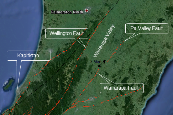
The image below is what I'll be putting on the page I'm writing now, the "graben" in the center is the Wairarapa Valley in this case.
The Pa Valley Fault would be the right hand side of the image, Wellington Fault on the left side (Tararua Mts)
I was over in that area recently (last Aug) and the terrain is quite bumpy, all crumpled up like the land has been pushed in from the sea towards the Valley like a loose rug on a timber floor.
My limited lower north island Fault KML files shows the Pa Valley Fault could be an extension of the Wairarapa Fault, which popped the 8.2 in 1855, there is only 8.5km separating the two of them.
I don't think it was a Thrust Quake. The media (and earthquake report.com) are comparing it to the Weber 1990-2 Series, but that was quite a bit further north and on a different fault. I think they have it wrong.
The image below is what I'll be putting on the page I'm writing now, the "graben" in the center is the Wairarapa Valley in this case.
The Pa Valley Fault would be the right hand side of the image, Wellington Fault on the left side (Tararua Mts)
I was over in that area recently (last Aug) and the terrain is quite bumpy, all crumpled up like the land has been pushed in from the sea towards the Valley like a loose rug on a timber floor.
edit on 01u202014 by muzzy because: brain and fingers not working in synchronicity
My limited lower north island Fault KML files shows the Pa Valley Fault could be an extension of the Wairarapa Fault, which popped the 8.2 in 1855, there is only 8.5km separating the two of them.
edit on 01000000202014 by muzzy because: (no reason given)

reply to post by sageturkey
guess she diddend like some of the comments :-D
wants the respect of wat she's able too...
guess she diddend like some of the comments :-D
wants the respect of wat she's able too...
edit on 21-1-2014 by ressiv because: (no reason given)
As of just after 5pm NZST we have 618 aftershocks of the Eketahuna 6.2ML (6.3Mw) quake
interactive map (the easy way, NZ 20+21st files combined!)
doesn't show the last 29 since noon (midnight 21st UTC)
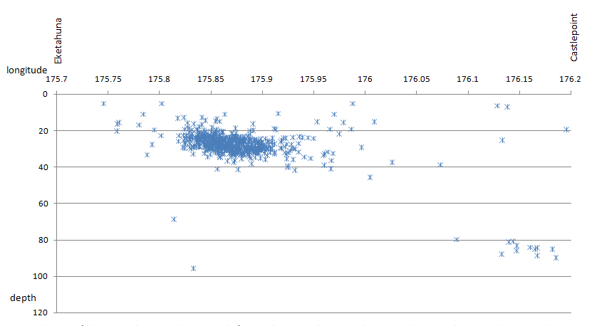
Interesting how those M3's (grey icons) over near Castlepoint (east coast) are deeper (80-90km) versus the Pa Valley Fault ones, one would suppose then that the Eketahuna ones (approx 30km deep) are on the overlying Australian Plate ................. need to do a cross section graph and see whats happening there with this .......
hmmmmm, graph confirms this is not on the Wadati Benioff subduction zone which here along the east coast is sloping downwards East to West, so confirms these aftershocks are in fact "normal faulting"
interactive map (the easy way, NZ 20+21st files combined!)
doesn't show the last 29 since noon (midnight 21st UTC)
Interesting how those M3's (grey icons) over near Castlepoint (east coast) are deeper (80-90km) versus the Pa Valley Fault ones, one would suppose then that the Eketahuna ones (approx 30km deep) are on the overlying Australian Plate ................. need to do a cross section graph and see whats happening there with this .......
edit on 01u212114 by muzzy because: (no reason given)
hmmmmm, graph confirms this is not on the Wadati Benioff subduction zone which here along the east coast is sloping downwards East to West, so confirms these aftershocks are in fact "normal faulting"
edit on 01u212114 by muzzy because: (no reason given)
new topics
-
Big Storms
Fragile Earth: 7 minutes ago -
Where should Trump hold his next rally
2024 Elections: 2 hours ago -
Shocking Number of Voters are Open to Committing Election Fraud
US Political Madness: 3 hours ago -
Gov Kristi Noem Shot and Killed "Less Than Worthless Dog" and a 'Smelly Goat
2024 Elections: 4 hours ago -
Falkville Robot-Man
Aliens and UFOs: 4 hours ago -
James O’Keefe: I have evidence that exposes the CIA, and it’s on camera.
Whistle Blowers and Leaked Documents: 5 hours ago -
Australian PM says the quiet part out loud - "free speech is a threat to democratic dicourse"...?!
New World Order: 6 hours ago -
Ireland VS Globalists
Social Issues and Civil Unrest: 6 hours ago -
Biden "Happy To Debate Trump"
2024 Elections: 7 hours ago -
RAAF airbase in Roswell, New Mexico is on fire
Aliens and UFOs: 7 hours ago
top topics
-
A Warning to America: 25 Ways the US is Being Destroyed
New World Order: 16 hours ago, 21 flags -
Blast from the past: ATS Review Podcast, 2006: With All Three Amigos
Member PODcasts: 9 hours ago, 13 flags -
James O’Keefe: I have evidence that exposes the CIA, and it’s on camera.
Whistle Blowers and Leaked Documents: 5 hours ago, 12 flags -
Australian PM says the quiet part out loud - "free speech is a threat to democratic dicourse"...?!
New World Order: 6 hours ago, 11 flags -
Biden "Happy To Debate Trump"
2024 Elections: 7 hours ago, 10 flags -
Mike Pinder The Moody Blues R.I.P.
Music: 9 hours ago, 8 flags -
What is the white pill?
Philosophy and Metaphysics: 8 hours ago, 6 flags -
Ireland VS Globalists
Social Issues and Civil Unrest: 6 hours ago, 5 flags -
RAAF airbase in Roswell, New Mexico is on fire
Aliens and UFOs: 7 hours ago, 5 flags -
Putin, Russia and the Great Architects of the Universe
ATS Skunk Works: 12 hours ago, 4 flags
active topics
-
Biden "Happy To Debate Trump"
2024 Elections • 47 • : JadedGhost -
University of Texas Instantly Shuts Down Anti Israel Protests
Education and Media • 312 • : marg6043 -
Gov Kristi Noem Shot and Killed "Less Than Worthless Dog" and a 'Smelly Goat
2024 Elections • 30 • : TheMisguidedAngel -
Big Storms
Fragile Earth • 1 • : lilzazz -
President BIDEN's FBI Raided Donald Trump's Florida Home for OBAMA-NORTH KOREA Documents.
Political Conspiracies • 36 • : BingoMcGoof -
ALERT - U.S. President JOE BIDEN Examined and Found NOT OF SOUND MIND.
2024 Elections • 64 • : WeMustCare -
What is the white pill?
Philosophy and Metaphysics • 19 • : TheDiscoKing -
Krystalnacht on today's most elite Universities?
Social Issues and Civil Unrest • 11 • : TheWoker -
Remember These Attacks When President Trump 2.0 Retribution-Justice Commences.
2024 Elections • 59 • : TzarChasm -
Salvador Dali's Moustaches
People • 29 • : GENERAL EYES