It looks like you're using an Ad Blocker.
Please white-list or disable AboveTopSecret.com in your ad-blocking tool.
Thank you.
Some features of ATS will be disabled while you continue to use an ad-blocker.

Major Storm Threatens British Christmas
page: 1share:
I'm actually quite concerned about this. It's going to be very windy over the weekend and we've had several storms over the past weeks, but there
is potential for the Christmas Eve storm to be the worst yet and perhaps on a par with the
Braer Storm of Jan '93
The latest MetO release is here:
www.metoffice.gov.uk...
But this was issued before the latest model output, which suggests the storm could be much worse than currently thought (but being model predictions, it could also be less severe)
It could be the worst storm to hit Britain in recent years. (But it might not be)
Anyway, this is just a heads up at this stage for anyone in Northern Ireland, Scotland and NW England especially to think about their travel plans - and also if in a place prone to power cuts to bear that in mind too.
Oh, and there may be another storm on the 27th as well ......
I'll post updates over the weekend
My fence has already blown down. I won't bother putting it back up just yet. Thanks for the heads up.
reply to post by AndyMayhew
Thank you for the heads up Andy...the weather here is a bit mental just now, and it seems we have a new storm every few days. It could be worse, and at least wind and rain keep the temperatures up.
Thank you for the heads up Andy...the weather here is a bit mental just now, and it seems we have a new storm every few days. It could be worse, and at least wind and rain keep the temperatures up.
the storm that hit Scotland a few weeks ago was an absolute beast early in the morning.. I was on the move at 6am and trees where horizontal, winds of
134mph +... I laugh at next weeks storms.
I don't know how this latest storm can be quoted as the worst since 93, when the one two weeks ago was the worst in 100 years???
I don't know how this latest storm can be quoted as the worst since 93, when the one two weeks ago was the worst in 100 years???
Yeah, it's gonna be interesting. Latest Met Office advice is that they think it will all calm down on Chrimbo day itself and possibly snow. It won't
snow here on the NW coast though, as it never does!
Either way it could prove interesting as I'm supposed to be firing up the barbie for Christmas dinner! Luckily we have done the menu so that it can be cooked in the oven/on the grill if needs be.
Thankfully I have Christmas Eve off for the first time in 5 years, so I won't be out in whatever nastiness ensues- I can stay in with the 60 bottles of wine I've just filled (d'ya think that'll be enough?)!
Good luck to you guys, sounds like you need it.
I recently discovered a website called "European Storm Forecast Experiment". I like their maps and their accuracy so far. Here's what they have in store for you:
The site: www.estofex.org...
They update their forecasts every day.
I recently discovered a website called "European Storm Forecast Experiment". I like their maps and their accuracy so far. Here's what they have in store for you:
A level 1 and level 2 were issued for Ireland, parts of the UK and the North Sea for severe convective wind gusts.
Further West, the warm sector of an outstanding Atlantic cyclone will overspread the British Isles with plentiful rain and 850 hPa winds up to 40 m/s. Scattered to widespread severe wind gusts are expected in the warm sector, where the pressure gradient is strongest, as well as along and behind the cold front, which will swiftly cross Ireland and Scotland after 18 UTC before it will gradually decelerate over England and the North Sea. It will mark the transition from rain to showers and isolated thunderstorms, which can easily mix down 850 hPa winds which are still between 25 and 30 m/s in the postfrontal air mass. A level 1 was drawn for those areas where an involvement of deep convection in the gust generation is expected. The Scottish West coast and the Hebrides were upgraded to a level 2, since they are favourably placed in the left exit region of a very strong jet streak. Hence deeper and more widespread convection, possibly in form of an organized line along the cold front, with an even higher risk of severe wind gusts is anticipated.
Additional subordinate risks are localized flooding (the convective contribution to the high rainfall totals will be small, though) and a brief tornado along the cold front, which is preceded by a tongue of very moist air (2m dewpoints up to 10°C) and strong directional wind shear.
The site: www.estofex.org...
They update their forecasts every day.
So much for a 'white Christmas' this year then!
It's been raining quite heavily for weeks now where I live, so I doubt I'll be that surprised by a major storm if it comes by.
It's been raining quite heavily for weeks now where I live, so I doubt I'll be that surprised by a major storm if it comes by.
Not much change in model output this morning, with central pressure still looking around 930mb and the strongest winds on Christmas Eve likely across
southern Scotland (including the Central Belt). However all parts very windy throughout Monday and Tuesday - indeed, Monday could well be bad
across southern England (where gales are also less common), not helped by a very active cold front/squall line moving down across the country.
But worth adding that flooding could also be a concern in some areas with central southern England, for example, possibly seeing 2 inches of rain (that's about a month's worth) over the next few days - heavy rain also in western parts of Wales, Cumbria and Scotland.
Christmas Day does still look like being much calmer though - with a few showers in the west which may give some sleet or snow, especially over hills, and also the Scottish Highlands.
edit on 21-12-2013 by AndyMayhew because: (no reason given)
Has anyone noticed how many Britons lives are so bland and boring that they have to make a mountain out of a molehill.
A month ago we were told to get ready for 90 days of harsh cold winter snow with Britain grinding to a halt.
So far, zilch. Its actually quite mild considering this time of year.
Can the pommies not handle a normal 70 mile / hour annual winter storm anymore or an amazing once in a generation storm where 5ft thickness of a 100ft high raised beach cliff gets hit and turns the sea brown 1km out to sea ?
Rapha
A month ago we were told to get ready for 90 days of harsh cold winter snow with Britain grinding to a halt.
So far, zilch. Its actually quite mild considering this time of year.
That's because the only people predicting it were a hack journalist and his mates down the pub No real meteorologist was saying anything of the sort! Indeed, the Met Office were predicting a mild December ....
Can the pommies not handle a normal 70 mile / hour annual winter storm anymore or an amazing once in a generation storm where 5ft thickness of a 100ft high raised beach cliff gets hit and turns the sea brown 1km out to sea ?
We're a very densely populated country that doesn't often have severe storms. This means that when they do occur, homes are damaged and people die. That's no laughing matter, especially just before Christmas.
Anyway, the MetO have rightly extended their warnings for almost the whole of the country now.
Still looks like England will be hit worst on Monday (a very active squall line coming through, with heavy rain as well as severe wind gusts) whilst the very strongest winds will hit Scotland - including the Central Belt - on Christmas Eve.
Christmas Day continues to look much better.
This is from my professional meteorologist friend Bren Jones, who now works for an independent Met company, Metdesk:
Not much to add other than to say some friends on the Met industry are suggesting this could be one of the worst storms to ever hit Britain - bearing in mind the whole country is going to be affected (as opposed to, say, the St Jude's Day storm than only affected a small swathe of SE England, or, indeed, many similar winter storms that normally only affect the NW of Scotland). I'd be surprised if the MetO do not upgrade their warnings to amber today.
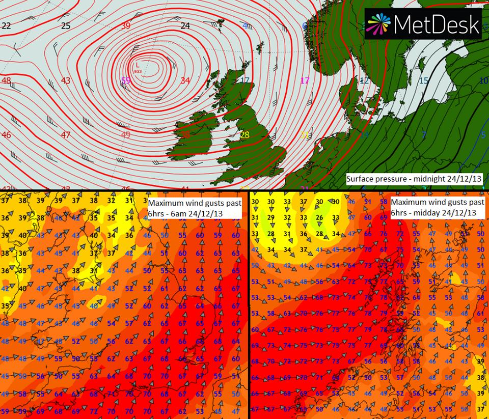
We're still tracking the intense storm heading our way for Christmas Eve. As the graphic shows, latest wind gust predictions suggest that southern and eastern parts of England will see gusts of 60-70kts (70-80mph) overnight into the morning of the 24th, associated with a cold front. A few hours later, the peak gusts transfer to north-western Scotland around the low centre, where gusts could exceed 70kts (80mph). Winds of this strength will be capable of creating disruption, particularly across the south where population density is greater and the incidence of very strong winds is lower
Not much to add other than to say some friends on the Met industry are suggesting this could be one of the worst storms to ever hit Britain - bearing in mind the whole country is going to be affected (as opposed to, say, the St Jude's Day storm than only affected a small swathe of SE England, or, indeed, many similar winter storms that normally only affect the NW of Scotland). I'd be surprised if the MetO do not upgrade their warnings to amber today.
reply to post by Rapha
Only if you read the Express was anyone saying that - any other meteorologist worth their salt never made any such predictions.
I also don't think that condescending attitude of yours is particularly helpful, or even welcome. The use of the word Pommies is unnecessary as well, although that betrays your antipodean roots where the only weather you get is hot, damned hot or just plain old fire. At least our weather is varied and interesting, which is why us "Pommies" are so obsessed by it.
I always thought it was our weather's variability and unpredictability that fascinated us so much. It's not unheard of to experience all four
seasons in one day!
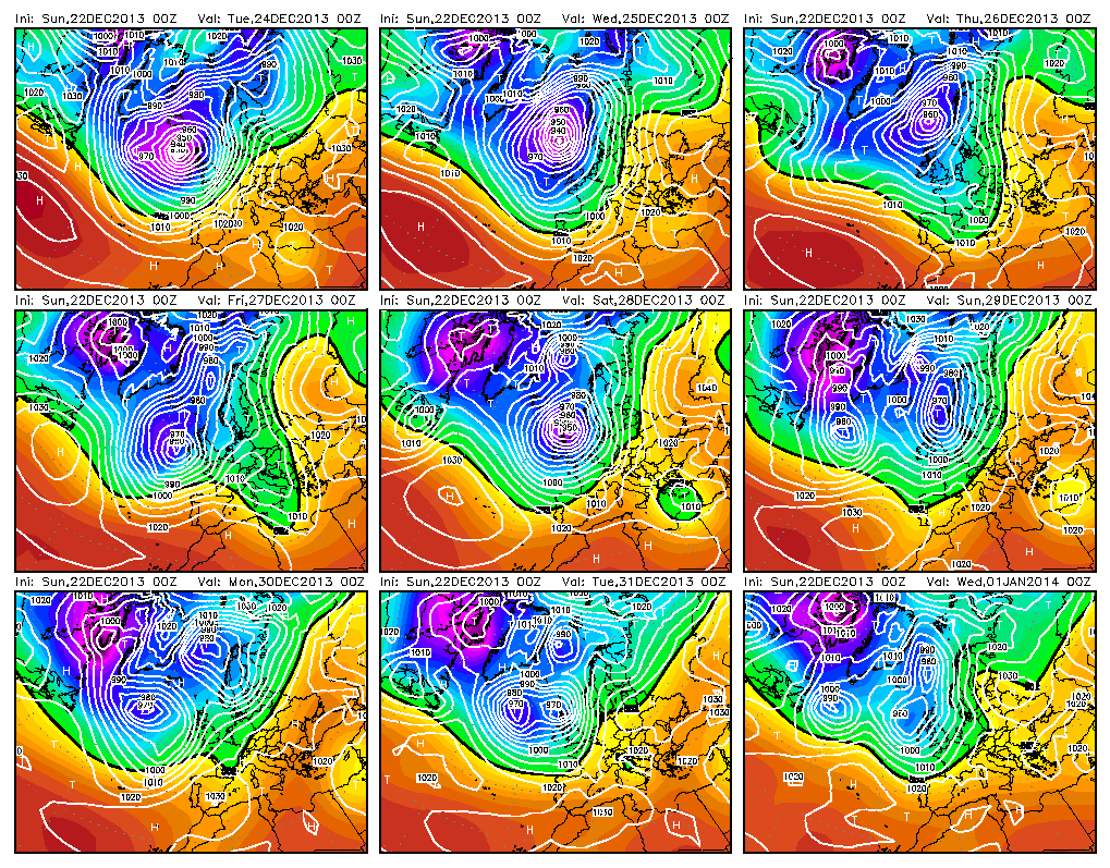
This composite of charts from the European (ECMWF) model shows just how unsettled the end of December will be. Note not just the intense depression
on the 24th/25th but another one crossing Scotland on the 27th/28th that could again bring 70-80mph gusts across most of the British Isles.
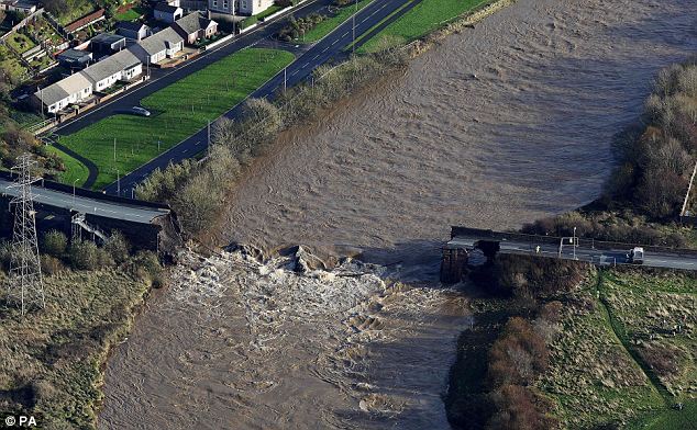
West Cumbria is underwater again, almost as bad as the 2009 floods when PC Bill Barker sadly lost his life standing on the main road bridge over the
river Derwent as it collapsed.
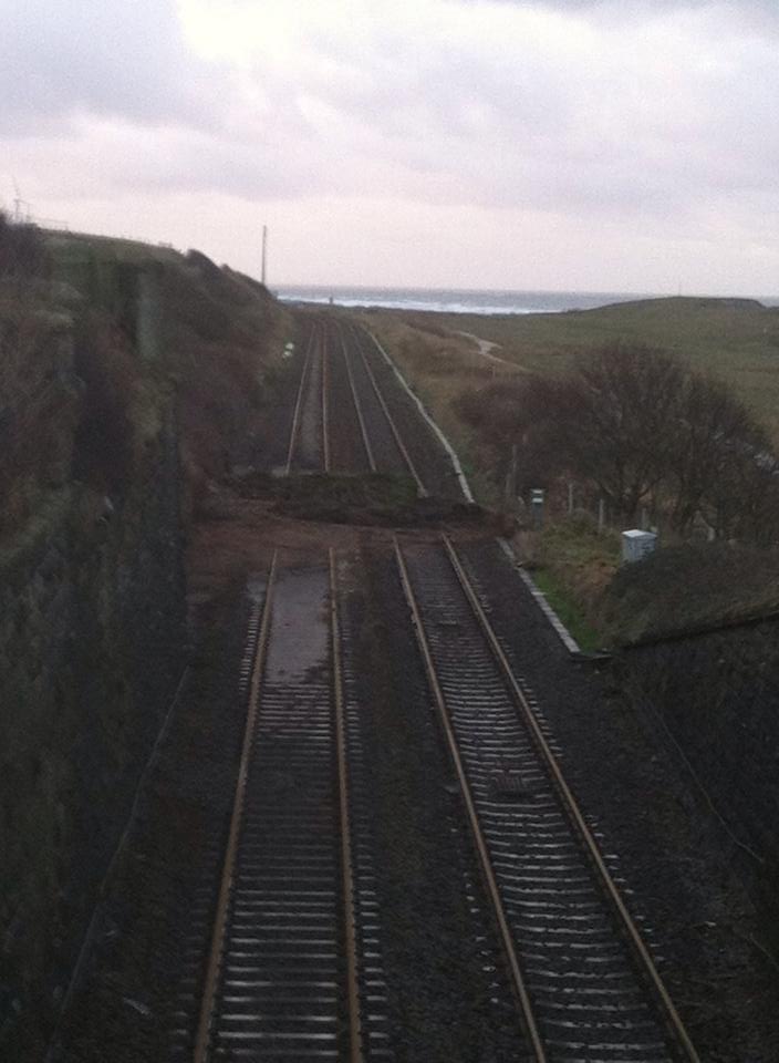
Here is some photos from last night... (awesome thunder btw)
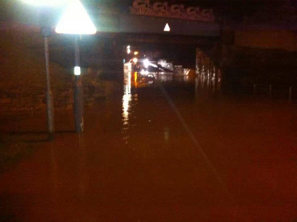
Railway line between Workington and Whitehaven
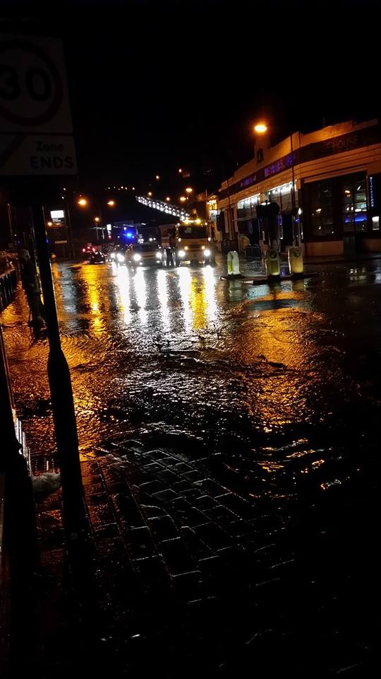
Whitehaven town centre
Workington
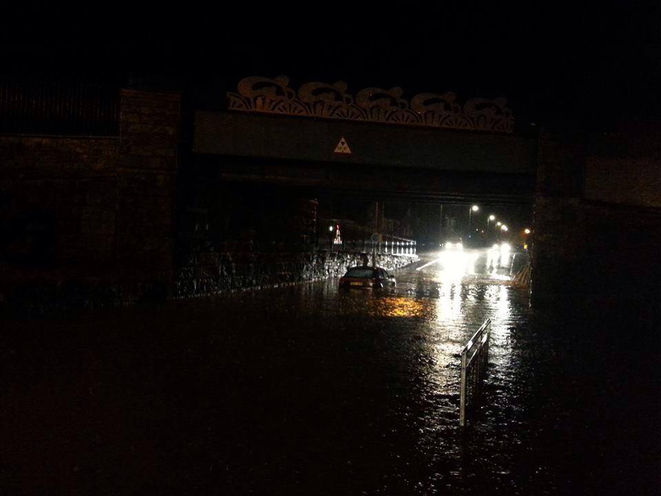
Workington (same place, different angle)
And finally a reminder of the 2009 floods and Northside bridge...
Apparently it's going to get worse over the coming few days.
Here is some photos from last night... (awesome thunder btw)
Railway line between Workington and Whitehaven
Whitehaven town centre
Workington
Workington (same place, different angle)
And finally a reminder of the 2009 floods and Northside bridge...
Apparently it's going to get worse over the coming few days.
reply to post by woogleuk
You guys all have webbed toes though don't you?
Or is that East Anglian's? If it is, you'd better get evolving!
You guys all have webbed toes though don't you?
Or is that East Anglian's? If it is, you'd better get evolving!
reply to post by stumason
No webbed toes, but I do plan on buying a rubber dinghy in the near future.
I'm telling you, in just 10 years time the great north/south divide will be a huge river running from the east coast to the west.
No webbed toes, but I do plan on buying a rubber dinghy in the near future.
I'm telling you, in just 10 years time the great north/south divide will be a huge river running from the east coast to the west.
Well, we're in for a very wet and windy day today ..... Feel free to post reports.
Latest from the BBC:
www.bbc.co.uk...
www.bbc.co.uk...
Meanwhile, models have been consistent in showing Friday's storm as tracking further south and bringing more severe gales most likely across Ireland, Wales and Central and Northern England - this could be even worse for some. Oh, and looks rather wet across the south next Monday so more flooding possible for the end of the year. It's going to be a long rough ride to 2014.
Stay safe!
Taking a less alarmist stance:
"Major Storm" : AKA Winter weather
"Threatens": AKA Occurs during
"Christmas": AKA Public Holiday where most people are at home
Every time it's rainy or windy someone on ATS has to highlight it.
I blame the US and it's obsession with reporting actual extreme weather ..
UK tries to emulate but ends up with a mud slide and a few flooded new builds in Norfolk pffft
I can confirm it is very windy and very wet in the west of England. A great day for Ducks!!
new topics
-
A Warning to America: 25 Ways the US is Being Destroyed
New World Order: 2 hours ago -
President BIDEN's FBI Raided Donald Trump's Florida Home for OBAMA-NORTH KOREA Documents.
Political Conspiracies: 8 hours ago -
Maestro Benedetto
Literature: 9 hours ago -
Is AI Better Than the Hollywood Elite?
Movies: 9 hours ago
top topics
-
President BIDEN's FBI Raided Donald Trump's Florida Home for OBAMA-NORTH KOREA Documents.
Political Conspiracies: 8 hours ago, 27 flags -
Weinstein's conviction overturned
Mainstream News: 17 hours ago, 8 flags -
Gaza Terrorists Attack US Humanitarian Pier During Construction
Middle East Issues: 14 hours ago, 8 flags -
Massachusetts Drag Queen Leads Young Kids in Free Palestine Chant
Social Issues and Civil Unrest: 16 hours ago, 7 flags -
Las Vegas UFO Spotting Teen Traumatized by Demon Creature in Backyard
Aliens and UFOs: 13 hours ago, 6 flags -
A Warning to America: 25 Ways the US is Being Destroyed
New World Order: 2 hours ago, 6 flags -
Meadows, Giuliani Among 11 Indicted in Arizona in Latest 2020 Election Subversion Case
Mainstream News: 16 hours ago, 5 flags -
2024 Pigeon Forge Rod Run - On the Strip (Video made for you)
Automotive Discussion: 14 hours ago, 4 flags -
Is AI Better Than the Hollywood Elite?
Movies: 9 hours ago, 3 flags -
The functionality of boldening and italics is clunky and no post char limit warning?
ATS Freshman's Forum: 15 hours ago, 1 flags
active topics
-
Massachusetts Drag Queen Leads Young Kids in Free Palestine Chant
Social Issues and Civil Unrest • 16 • : FlyersFan -
President BIDEN's FBI Raided Donald Trump's Florida Home for OBAMA-NORTH KOREA Documents.
Political Conspiracies • 18 • : nugget1 -
Gaza Terrorists Attack US Humanitarian Pier During Construction
Middle East Issues • 33 • : FlyersFan -
Weinstein's conviction overturned
Mainstream News • 24 • : burritocat -
-@TH3WH17ERABB17- -Q- ---TIME TO SHOW THE WORLD--- -Part- --44--
Dissecting Disinformation • 690 • : burritocat -
University of Texas Instantly Shuts Down Anti Israel Protests
Education and Media • 266 • : SchrodingersRat -
New whistleblower Jason Sands speaks on Twitter Spaces last night.
Aliens and UFOs • 66 • : baablacksheep1 -
HORRIBLE !! Russian Soldier Drinking Own Urine To Survive In Battle
World War Three • 50 • : F2d5thCavv2 -
Russia Ukraine Update Thread - part 3
World War Three • 5732 • : F2d5thCavv2 -
The Acronym Game .. Pt.3
General Chit Chat • 7751 • : F2d5thCavv2