It looks like you're using an Ad Blocker.
Please white-list or disable AboveTopSecret.com in your ad-blocking tool.
Thank you.
Some features of ATS will be disabled while you continue to use an ad-blocker.

Volcano Watch 2014
page: 2share:
reply to post by PuterMan
Water + Heat = water vapor
Clouds are forming over top of fault lines, meanwhile waters at the same latitude are dead quiet. I'm not asking anyone to believe me, or take my word. I'm limited to what I can do on this computer, trapped in my own home. Most of you are not. I want others to do what I can not: GO LOOK.
Do not believe me. Do not trust me. Think for yourself. Do not let anyone else think for you.
Some early year doom porn for my fellow volcano lovers!
Supervolcanoes erupt by their own rules
Very basically (read the article for a proper breakdown) it seems geologists have identified that supervolcanoes have different eruptive triggers to smaller volcanoes. They have discovered that volcanoes up to 500 cubic km (small volcanoes) erupt as we always assumed - a build up of pressure leads to an eruption.
Supervolcanoes, it has been discovered, do not play by these rules. As the magma chambers are so vast, the pressure build up is nothing like as intense. Instead, as the magma builds up, there is so much of it that the buoyancy of it cracks the rock / ground above the chamber, triggering an eruption. In other words, many of the traditional eruptive indicators do not come into play for supervolcanoes.
I still haven't woken up properly yet, so am getting my head around this still! I have to say though, while it clearly isn't worth worrying about, if i lived by one i would still be panicking like mad every time i noticed a crack in the ground!
Volcano erupts more than 50 times: Indonesia danger zone extended
Authorities have extended a danger zone around a rumbling volcano in western Indonesia after it spewed blistering gas farther than expected.
National Mitigation Agency spokesman Sutopo Purwo Nugroho says more than 50 eruptions on Saturday sent lava and searing gas tumbling out of Mount Sinabung in North Sumatra province down the southeastern slopes up to 5 kilometers (3 miles) away.
He said the volcano's danger zone to the southeast was extended from five to seven kilometers (three to four miles) after the new eruption.
It was still spitting clouds of gas and lava as high as 4,000 meters (13,000 feet) on Sunday, but no casualties were reported.
More than 20,000 people have been evacuated from villages around the crater into several temporary shelters.
Sinabung has been erupting since September.
Source
Looking more in to the connection between vulcanism and electricity, I have found the following paper recently published:
Estimation of eruption site location using volcanic lightning
Þórður Arason
Guðrún Nína Petersen
Halldór Björnsson
They are using volcanic lighting strike locations to determine the exact location of the vent as all other means are not sufficient to make a close enough approximation.
From this, they are able to more accurately gauge the place where magma broke the surface.
More to come
Eruption of subglacial volcanoes may lead to catastrophic floods and therefore early determination of the exact eruption site may be critical to civil protection evacuation plans. Poor visibility due to weather or darkness often inhibit positive identification of exact eruption location for many hours. However, because of the proximity and abundance of water in powerful explosive subglacial volcanic eruptions, they are probably always accompanied by early lightning activity in the volcanic column.
Estimation of eruption site location using volcanic lightning
Þórður Arason
Guðrún Nína Petersen
Halldór Björnsson
They are using volcanic lighting strike locations to determine the exact location of the vent as all other means are not sufficient to make a close enough approximation.
The best available data for the current analysis, Grímsvötn 2011, is shown in Figure 5. After only 30 min from the start of the eruption one could have seen from the lightning data that the median location was 2‒3 km south of the correct location. With a simple wind correction the estimate would indicate 2 km WSW of the 2004 site. After 3 hours the estimate would have indicated that the eruption site was about 1 km W of the 2004 site. Four hours into the eruption (at 22:00 UTC) the wind corrected estimates are all within 1 km of the actual eruption crater, see Figure 6.
From this, they are able to more accurately gauge the place where magma broke the surface.
More to come
interresting :
www.theguardian.com...
an clue for the yellowstone swarms?
www.theguardian.com...
an clue for the yellowstone swarms?
edit on 7-1-2014 by ressiv because: (no reason given)
Not sure if this belongs to volcano or earthquake thread, but there seems to be some activity in Langjökull (Long Glacier) in Iceland. The area is
volcanically relatively quiet compared to the rest of Iceland. There has only been 32 eruptions in the last 10 000 years. There has been thought to be
2 different volcanic systems or more under the glacier.
The volcano erupted last time around ~925 AD, so it has been quiet for very long time.

en.vedur.is...=map
The volcano erupted last time around ~925 AD, so it has been quiet for very long time.
en.vedur.is...=map
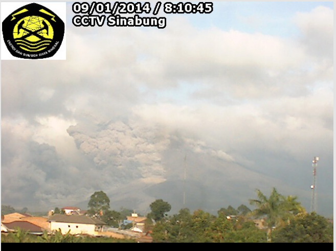
Pyroclastic flows continue to travel 2-4 km down the SE flank of Mt. Sinabung.
I have to make a post so I can save this thread.
I didn't discover this til Dec.2013, and don't want to lose it again! lol
I'm watching for two specific volcanoes acting up- Vesuvius, and Pelee. I know they're sleeping; just hope they stay that way.
I didn't discover this til Dec.2013, and don't want to lose it again! lol
I'm watching for two specific volcanoes acting up- Vesuvius, and Pelee. I know they're sleeping; just hope they stay that way.
I caught this pyroclastic flow on the Sinabung webcam just a few minutes
ago. (It's cloudy, so the view comes & goes. Scroll down the page to the 4th webcam down)
Over 22,000 villagers have been displaced because of this ongoing activity.
Earlier today I read a good short write up by Erik Klemetti at his Wired Eruptions blog.
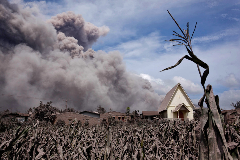
I also found some amazing photos in this NY Post gallery, such as the one below:
Over 22,000 villagers have been displaced because of this ongoing activity.
Earlier today I read a good short write up by Erik Klemetti at his Wired Eruptions blog.
I also found some amazing photos in this NY Post gallery, such as the one below:
edit on 1/8/2014 by Olivine because: more info
Quake swarm in Askja (Icelandic for caldera) volcano, Iceland! That is one of most famous volcanoes in Iceland, and one of most dangerous too. Its
located north from Vatnajökull.

The volcano became famous when it erupted in 1875 and caused ash catastrophe. It killed almost whole livestock in eastern Iceland and caused massive emigration from Iceland. The eastern Iceland was pretty much poisoned after that, the land became useless for years.
In 2010 volcano expert Hazel Rymer said that the volcanic activity has clearly increased in Askja, and that eruption could be around the corner. In 2012 it was noticed that the caldera was completely free from ice, though it was April. There was clearly increased volcanic activity. After that the area has been closed from public, because of the poisonous gases.
Askja erupted last time in 1961 when it was VEI-2 eruption. The 1875 eruption was VEI-5. So its hard to say how strong the next eruption will be. There is no specific time between its eruptions, it has erupted: 1961, 1938, 1926, 1924, 1923, 1922, 1921, 1919, 1875, 1797 and 1300.
en.wikipedia.org...
www.volcano.si.edu...
edit on 13-1-2014 by Thebel because: (no reason given)
Kewl! Blue lava (well not actually lava but that is how they describe it)
Spetacular images
Google images as well.
And some Chilean volcano lightening
Incredible Photos of Spectacular Volcanic Eruption in Chile, Lighting Storm Included
And finally refresh your memory about a post in Quake Watch 6887 BC
Spetacular images
Google images as well.
edit on 19/1/2014 by PuterMan because: (no reason
given)
And some Chilean volcano lightening
Incredible Photos of Spectacular Volcanic Eruption in Chile, Lighting Storm Included
And finally refresh your memory about a post in Quake Watch 6887 BC
edit on 19/1/2014 by PuterMan because: (no reason given)
The somewhat peculiar decrease in volcanic activity since end November / start December continues.
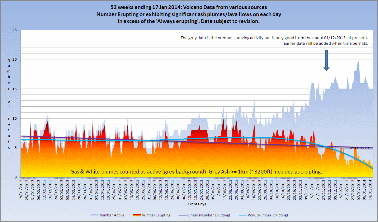
Click the image to enlarge
Unfortunately my records do not go back far enough yet to see if this has happened before, but coupled with the distinct lack of larger earthquakes one has to wonder............

Click the image to enlarge
Unfortunately my records do not go back far enough yet to see if this has happened before, but coupled with the distinct lack of larger earthquakes one has to wonder............
reply to post by PuterMan
I don't suppose it could be possibly connected to the Local Fluff?
An overall decrease in the energy released may be tied to a lowering of available energy being input to the system?
Unfortunately my records do not go back far enough yet to see if this has happened before, but coupled with the distinct lack of larger earthquakes one has to wonder............
I don't suppose it could be possibly connected to the Local Fluff?
An overall decrease in the energy released may be tied to a lowering of available energy being input to the system?
reply to post by jadedANDcynical
Personally I think it is related to solar output, but some say decreased solar output increases volcanoes and earthquakes. Who knows???????
BTW another site for the 'blue lava' with 30 great images and text: Kawah Ijen by night
Personally I think it is related to solar output, but some say decreased solar output increases volcanoes and earthquakes. Who knows???????
BTW another site for the 'blue lava' with 30 great images and text: Kawah Ijen by night
reply to post by PuterMan
A little off topic , but Im still at an early stage of learning the science of earthquakes . Yesterday stumbled upon you graphs you made for earthquake watch 2014. I was impressed that someone took the time to make such a detailed graph , now Im certainly going to monitor earthquake watch very carefully in 2014 , what a great trustful site.
A little off topic , but Im still at an early stage of learning the science of earthquakes . Yesterday stumbled upon you graphs you made for earthquake watch 2014. I was impressed that someone took the time to make such a detailed graph , now Im certainly going to monitor earthquake watch very carefully in 2014 , what a great trustful site.
Activity at Grimsvotn
Sourece: Smithsonian from Icelandic Met Office
Maybe the jokulhlaup is an indication of some activity building up, however I don't see anything of note on the GRF tremor plot.
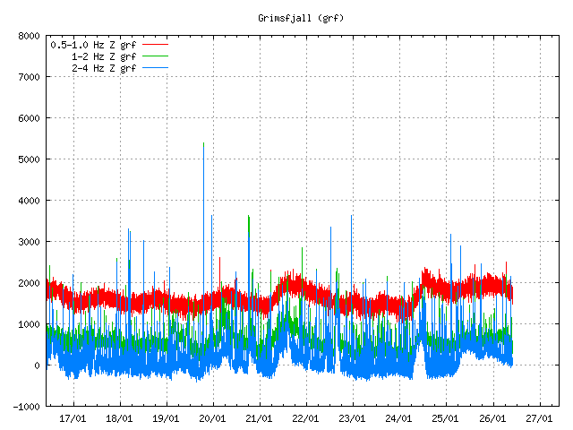
There does seem to be further activity after the dates given above (25th/26th) so perhaps we should be keeping an eye out on Grimsvotn as well as Askja
According to the Icelandic Meteorological Office, the level of the Skaftá river at Sveinstindur and electrical conductivity both rose during 18-19 January indicating a glacial outburst flood (jokulhlaup), originating from Grímsvötn's western Skaftá ice cauldron. The jokulhlaup was unconfirmed without visual observations, however. Flood waters peaked on 20 January and then began to subside on 21 January. The report noted that floods in Skaftá source from two ice cauldrons formed by persistent geothermal activity beneath Vatnajökull. The cauldrons drain an average every two years, producing floods of up to 1,500 cubic meters per second.
Sourece: Smithsonian from Icelandic Met Office
Maybe the jokulhlaup is an indication of some activity building up, however I don't see anything of note on the GRF tremor plot.
There does seem to be further activity after the dates given above (25th/26th) so perhaps we should be keeping an eye out on Grimsvotn as well as Askja
reply to post by jadedANDcynical
I guess the local fluff could cause a lull in activity if not active (In slightly old fashioned English parlance the 'local fluff' is a young lady who is willing - also known as the 'local bike')
This week continues to show the low level of activity.
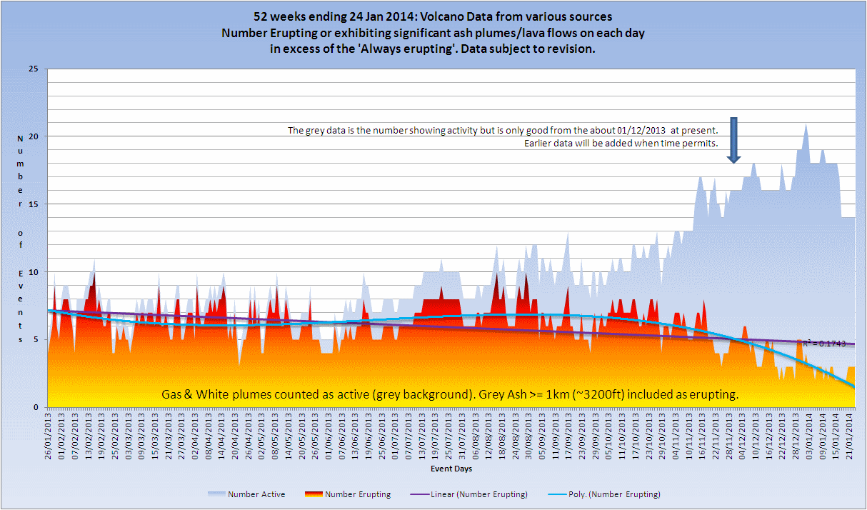
Click the image to enlarge
I guess the local fluff could cause a lull in activity if not active (In slightly old fashioned English parlance the 'local fluff' is a young lady who is willing - also known as the 'local bike')
This week continues to show the low level of activity.

Click the image to enlarge
Sinabung Volcano in it’s glory… Along with videos below, lots of info & amazing pics.
www.photovolcanica.com...
www.photovolcanica.com...
We should keep keeping our peepers on Sinabung. It's now claimed lives.
www.dailymail.co.uk...
Really sad stories and images.
Here's some video in a report.
www.youtube.com...
I don't think this means there's something bigger coming. It seems they let people back into the area. This eruption released the recent stress. However, in a few weeks, we could be seeing something similar, or bigger. It seems to be could more active as time goes on. It does not appear to be ebbing. I'm just noting that there was a recent new moon.
I just remembered, here's some really impressive video from NASA.
www.livescience.com...
I am stunned by the vantage point. You can see a massive steam bubble. I wish I could write more.
edit on 1-2-2014 by ericblair4891 because: (no reason given)
reply to post by PuterMan
volcano discovery
Know you are probably already watching it but in case...
Saturday, Feb 01, 2014 Kavachi undersea volcano (Solomon Islands) erupts again The discolored water plume from Kavachi volcano (NASA Earth Observatory image by Jesse Allen and Robert Simmon, using EO-1 ALI data from the NASA EO-1 team. Caption by Robert Simmon) The discolored water plume from Kavachi volcano (NASA Earth Observatory image by Jesse Allen and Robert Simmon, using EO-1 ALI data from the NASA EO-1 team. Caption by Robert Simmon) A submarine eruption is likely occurring at the submerged volcano. A NASA satellite image from 29 Jan shows a plume of discolored sea water swirling and drifting from the location of the volcano. The discoloration is likely from suspended volcanic sediments (the fragmented lava) and gasses. Kavachi is an undersea volcano on the southern edge of the Solomon Islands in the western Pacific Ocean. It erupted dozens of times in the 20th century, often breaking the water surface, only to be eroded back below the water line within a few months. Whether the new eruption will break the surface and create another new island remains to be seen. Directly above the undersea peak, a bright patch is visible that suggests vigorously churning water—but there is no sign that the eruption has broken the surface. (NASA)
volcano discovery
Know you are probably already watching it but in case...
new topics
-
Shocking Number of Voters are Open to Committing Election Fraud
US Political Madness: 35 minutes ago -
Gov Kristi Noem Shot and Killed "Less Than Worthless Dog" and a 'Smelly Goat
2024 Elections: 1 hours ago -
Falkville Robot-Man
Aliens and UFOs: 1 hours ago -
James O’Keefe: I have evidence that exposes the CIA, and it’s on camera.
Whistle Blowers and Leaked Documents: 2 hours ago -
Australian PM says the quiet part out loud - "free speech is a threat to democratic dicourse"...?!
New World Order: 3 hours ago -
Ireland VS Globalists
Social Issues and Civil Unrest: 3 hours ago -
Biden "Happy To Debate Trump"
Mainstream News: 4 hours ago -
RAAF airbase in Roswell, New Mexico is on fire
Aliens and UFOs: 4 hours ago -
What is the white pill?
Philosophy and Metaphysics: 5 hours ago -
Blast from the past: ATS Review Podcast, 2006: With All Three Amigos
Member PODcasts: 6 hours ago
top topics
-
A Warning to America: 25 Ways the US is Being Destroyed
New World Order: 13 hours ago, 21 flags -
Biden "Happy To Debate Trump"
Mainstream News: 4 hours ago, 8 flags -
Mike Pinder The Moody Blues R.I.P.
Music: 6 hours ago, 7 flags -
Blast from the past: ATS Review Podcast, 2006: With All Three Amigos
Member PODcasts: 6 hours ago, 7 flags -
What is the white pill?
Philosophy and Metaphysics: 5 hours ago, 5 flags -
James O’Keefe: I have evidence that exposes the CIA, and it’s on camera.
Whistle Blowers and Leaked Documents: 2 hours ago, 5 flags -
Australian PM says the quiet part out loud - "free speech is a threat to democratic dicourse"...?!
New World Order: 3 hours ago, 5 flags -
Ireland VS Globalists
Social Issues and Civil Unrest: 3 hours ago, 4 flags -
RAAF airbase in Roswell, New Mexico is on fire
Aliens and UFOs: 4 hours ago, 4 flags -
Putin, Russia and the Great Architects of the Universe
ATS Skunk Works: 9 hours ago, 3 flags
active topics
-
Gov Kristi Noem Shot and Killed "Less Than Worthless Dog" and a 'Smelly Goat
2024 Elections • 25 • : FlyersFan -
Falkville Robot-Man
Aliens and UFOs • 4 • : Kurokage -
The functionality of boldening and italics is clunky and no post char limit warning?
ATS Freshman's Forum • 13 • : JonnyC555 -
Candidate TRUMP Now Has Crazy Judge JUAN MERCHAN After Him - The Stormy Daniels Hush-Money Case.
Political Conspiracies • 805 • : Vermilion -
Shocking Number of Voters are Open to Committing Election Fraud
US Political Madness • 1 • : YourFaceAgain -
-@TH3WH17ERABB17- -Q- ---TIME TO SHOW THE WORLD--- -Part- --44--
Dissecting Disinformation • 700 • : Thoughtful3 -
Putin, Russia and the Great Architects of the Universe
ATS Skunk Works • 26 • : RussianTroll -
Re-election Tactic - JOE BIDEN Hints He May Put Books in the Homes of Black People.
2024 Elections • 30 • : WeMustCare -
Australian PM says the quiet part out loud - "free speech is a threat to democratic dicourse"...?!
New World Order • 3 • : Athetos -
Biden "Happy To Debate Trump"
Mainstream News • 35 • : WeMustCare