It looks like you're using an Ad Blocker.
Please white-list or disable AboveTopSecret.com in your ad-blocking tool.
Thank you.
Some features of ATS will be disabled while you continue to use an ad-blocker.

Volcano Watch 2014
page: 14share:
From USGS:
5.6 5km depth
5.2 8km depth
with in the last two hours
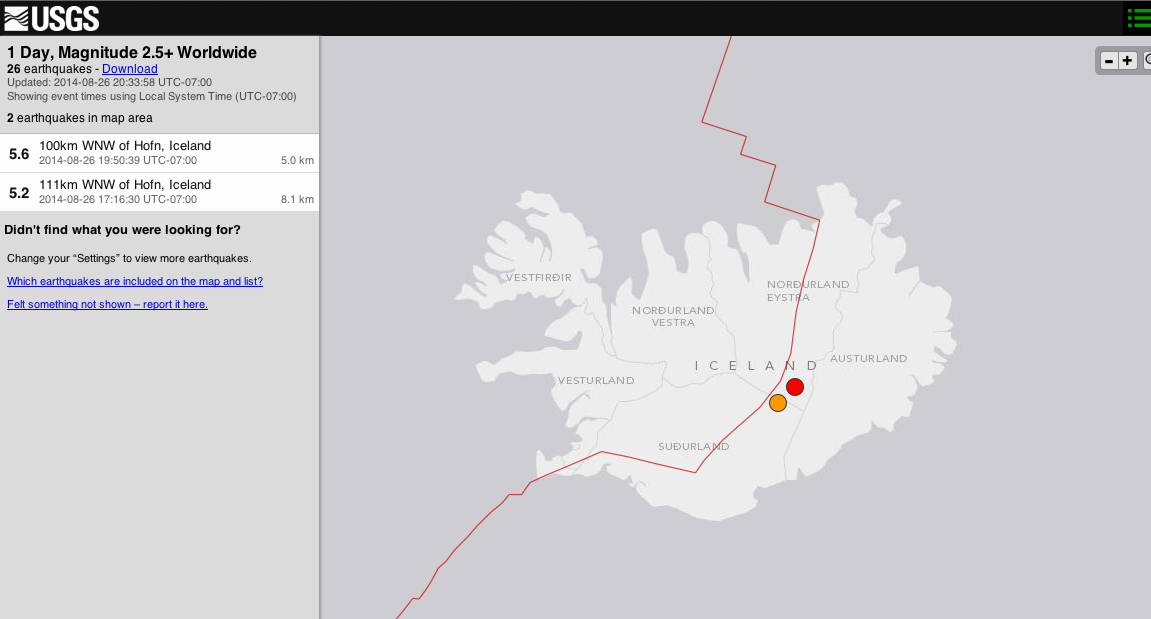
earthquake.usgs.gov...
5.6 5km depth
5.2 8km depth
with in the last two hours
earthquake.usgs.gov...
edit on 26-8-2014 by BGTM90 because: (no reason given)
a reply to: crappiekat
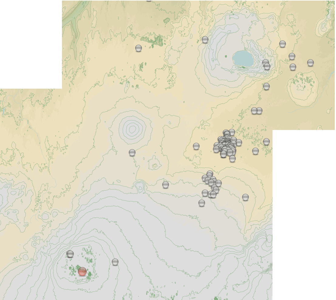
en.vedur.is...=table
use the earthquakes shown and select M3+, its easier to find those bigger ones
opna button means "open"
en.vedur.is...=table
use the earthquakes shown and select M3+, its easier to find those bigger ones
opna button means "open"
edit on 08u23723714 by muzzy because: (no reason given)
a reply to: muzzy
damn the page rolled over.
here,s the new animation, up till the end of the 26th (3 hours ago)
warning, its2.5MB size. (I compressed it to 1.8MB and reloaded it)
latest animation
damn the page rolled over.
here,s the new animation, up till the end of the 26th (3 hours ago)
warning, its
latest animation
edit on 0800000023723714 by muzzy because: (no reason given)
a reply to: muzzy
i do believe that "As you near the poles, the crust thins until eventually you have an opening or a hole ."
the crust thins,, and by the looks of things it was,, Northward Hoe!,, so to speak.
correct me if i am wrong.
i do believe that "As you near the poles, the crust thins until eventually you have an opening or a hole ."
the crust thins,, and by the looks of things it was,, Northward Hoe!,, so to speak.
correct me if i am wrong.
edit on 8/26/2014 by BobAthome because: entertainment.
a reply to: BobAthome
yikes it looks hot in there!
Who knows what lies beneath the South Pole, there is only one volcano there, Erebus, the nearest next ones are the South Sandwich Islands at the bottom of S. America.
maybe because there is not land at the North Pole its more liable to thinning.
fits with the Expanding Earth theory anyways
Hot Spots wander, currently its Iceland and Hawaii, apart from the sub-duction type eruptions going on in South and Central America a nd Japan, Indonesia etc.
Quite an interesting piece on Volcano discovery about
the two possible
types of fissure eruption at Bardabunga. The second one would not be good - that is a Laki style eruption that could be extremely bad for Europe
and N. America. The first one is am Eyja style eruption quite common in Iceland and elsewhere, and not quite as bad.
Seems like earthquake activity in Bardabunga is gained back. Yesterday it looked like it was going to die down, as quakes went deeper and deeper,
while activity went lower. There are several outcomes:
Bardabunga caldera collapses: Laki-type eruption with strong explosions at start, and long lasting eruption, spewing ash for a long time, even month.
Dike reaches surface: This would be less explosive, but there would be massive lava flows and it would change the landscape a lot. If this happens on glacier, it would cause ash emissions, but outside the glacier it wouldn't cause so much problems.
Activity dies down: The dike goes deeper and deeper. If no more magma comes from the mantle, the magma will cool down and pressure will go down. Activity stops completely and the magma just stays there, waiting for second change. This outcome is highly unlikely in this situation. All the signs say its going to erupt at some point.
And the longer the activity continues, more likely its going to erupt. Strong quakes within the caldera signal that the caldera is going down as the magma is escaping underneath it. Its only matter of time when caldera reaches point when its no longer supported, and it finally collapses.
A 4.5 depth 4km near Askja 5 hours ago, probably already checkes as quality 99%
Earthquakes have stopped at Bárðarbunga caldera (no red dots anymore) but this doesn't mean it's over there. We'll have to wait till some scientist has a look at the situation there.
Earthquakes have stopped at Bárðarbunga caldera (no red dots anymore) but this doesn't mean it's over there. We'll have to wait till some scientist has a look at the situation there.
I find it strange that the only thing the seems to concern most medias and some people of the scientific world is ash generated by a grey eruption
that would disturb air trafic.
They seem to ignore or avoid talking about the real issues if a fissure eruption would accur. And the issues isn't ash if a fissure eruption would occur, even outside the glacier.
They seem to ignore or avoid talking about the real issues if a fissure eruption would accur. And the issues isn't ash if a fissure eruption would occur, even outside the glacier.
further to post by : muzzy
map based on preliminary data yesterday from IMO
same data but reviewed manually 12 hours later
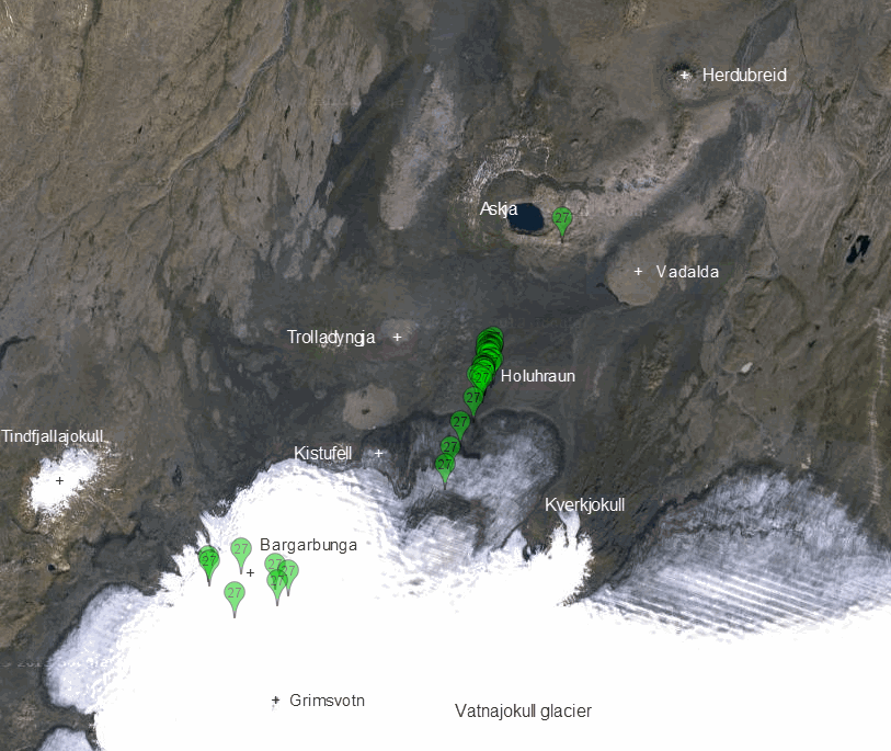
right click image, select "view image" for full size
Quite a difference eh
Askja not under threat of intrusion at all ( at this stage)
The earthquakes on the 27th seem to be stuck on the Holuhraun lava field.
Earthquake data on the preliminary maps/tables on IMO are derived from the SIL seismic network, which automatically detects and locates earthquakes in Iceland and the surrounding offshore region.
The weekly cataloged database is based on manual routine corrections of the automatic bulletin produced by the SIL system. The earthquake list that appears is not final and can contain some errors, but gives a good overview of earthquake activity.
So lets not get too wound up about what the IMO map/table is showing, the data is inaccurate.
Damn, I have run out of icon colours, 10 seems to be the limit, then they start to merge together with the slight alteration in colour. I'll have to change to numbered icons, I should be good for 99 days then.
I'll do it like the Mexicans
www2.ssn.unam.mx:8080...
also pulling back a zoom level to get Askja in the picture smudges the topography detail, I will have to change to the map/aerial background shown on the 2nd image, its the best I can find on GPS Visualiser that shows the terrain without all the crap laid over it.
I may just go interactive maps, same aerial/satellite background is available on Google Maps. I just haven't had time to process the detail for the popup tags yet.
map based on preliminary data yesterday from IMO
same data but reviewed manually 12 hours later
right click image, select "view image" for full size
Quite a difference eh
Askja not under threat of intrusion at all ( at this stage)
The earthquakes on the 27th seem to be stuck on the Holuhraun lava field.
Earthquake data on the preliminary maps/tables on IMO are derived from the SIL seismic network, which automatically detects and locates earthquakes in Iceland and the surrounding offshore region.
The weekly cataloged database is based on manual routine corrections of the automatic bulletin produced by the SIL system. The earthquake list that appears is not final and can contain some errors, but gives a good overview of earthquake activity.
So lets not get too wound up about what the IMO map/table is showing, the data is inaccurate.
Damn, I have run out of icon colours, 10 seems to be the limit, then they start to merge together with the slight alteration in colour. I'll have to change to numbered icons, I should be good for 99 days then.
I'll do it like the Mexicans
www2.ssn.unam.mx:8080...
also pulling back a zoom level to get Askja in the picture smudges the topography detail, I will have to change to the map/aerial background shown on the 2nd image, its the best I can find on GPS Visualiser that shows the terrain without all the crap laid over it.
I may just go interactive maps, same aerial/satellite background is available on Google Maps. I just haven't had time to process the detail for the popup tags yet.
edit on 08u23823814 by muzzy because: (no reason given)
Magnitude 4.0 under Askja caldera
Update Wed 27 Aug 17:57
also
Update Wed 27 Aug 17:57
Over 800 earthquakes have occurred today so far, mostly now beyond the edge of the Dyngjujökull glacier. The crisis is showing no signs of decreasing. The intrusion itself has migrated about 1 km northwards since yesterday, and approaches the Asjka volcanic complex, which is a worrying development. A magnitude 4 earthquake occurred this morning under the eastern caldera rim of Askja (s. image).
also
At 00:16 UTC today, a magnitude 5.3 earthquake occurred in the caldera of Bárðarbunga. At 02:50 UTC, another similar-sized earthquake (magnitude 5.2) took place in the same region.
At 01:52 UTC, a magnitude 4.5 earthquake was detected on the eastern side of the Askja volcano. This was followed by a few micro-earthquakes in the same area.
The dyke intrusion beneath Dyngjujökull is thought to be about 40 km in length.
Modelling of GPS data indicates that about 20 million cubic metres of magma have been added to the volume of the intrusion in the last 24 hours.
Modelling results suggest that the dyke intrusion is causing stress changes over a large area, including the region to the north of the dyke's extent; this could account for the increased seismicity at Askja volcano.
originally posted by: Nidwin
I find it strange that the only thing the seems to concern most medias and some people of the scientific world is ash generated by a grey eruption that would disturb air trafic.
They seem to ignore or avoid talking about the real issues if a fissure eruption would accur. And the issues isn't ash if a fissure eruption would occur, even outside the glacier.
Yes, no one wants to talk about what will happen if this goes south with profound impacts all over the northern hemisphere. I think it's the head in the sand mindset.
It frankly worries me more than when they are trying to panic people with all their doom porn reporting. Look at how often they waste no chance telling us how scary Ebola is, how scary Global Warming is, how scary ISIS is, etc., as though they are trying to panic us, but here we have a potential real northern hemisphere encompassing disaster in the making and we here *crickets.*
Now, let's be plain. The odds are that this will still be a relatively normal event, either a medium sized rifting event or small caldera event or that it subsides. Those scenarios are still more likely. But as every day goes by with a reliable and vigorous pattern of magma movement and earthquakes, the other scenarios also creep up in likelihood, too.
At what point does a responsible media begin to discuss them, or is ignorance truly bliss when the disaster could actually happen?
a reply to: whatnext21
That's a nasty scenario. double caldera at Askja and Bardy with a rift in between. Thankfully that is the least likely scenario. That's like 2012 movie likely at this point.
That's a nasty scenario. double caldera at Askja and Bardy with a rift in between. Thankfully that is the least likely scenario. That's like 2012 movie likely at this point.
I'm just re-posting the live link.
I've been glued to it for a few days...
If this volcano does go,
it might be a once in a lifetime thing to witness.
I've been glued to it for a few days...
If this volcano does go,
it might be a once in a lifetime thing to witness.
edit on 27-8-2014 by Darkblade71 because: (no reason given)
a reply to: Darkblade71
I know. I've had this thing open in the background on my PC at work ... just peeking every 10 or 15 hoping I won't miss anything even though most of the big action happens in the evening.
I know. I've had this thing open in the background on my PC at work ... just peeking every 10 or 15 hoping I won't miss anything even though most of the big action happens in the evening.
a reply to: ketsuko
I also think they should educate people more on this event. That's our media and why I come here.
I read that the worst event having to do with this area caused the longest and coldest winter in the history of the US, caused crop failures through Europe and India, and of course killed a lot of people in both Iceland and abroad. The 14th and 17/18th centuries also correspond to low sunspot activity and other V6 eruptions. From what I read, this area on its own managed to alter the climate and weather patterns (violent storms, etc).
In the 17th century this area was in eruption status for 8 months. It's hard to imagine the impact of that today. Flying will be the least of people's worries if this performs at the levels it did then. The longer it acts up the more concerning it becomes. If it would just erupt already it may release some pressure and calm down (my laymen assessment).
If anyone can read this and translate it, I do believe it has to do with the cracks they spotted from the air around Barðarbunga Volcano.
Pretty impressive pictures.
ruv.is...
I used google translator to get a part of it:
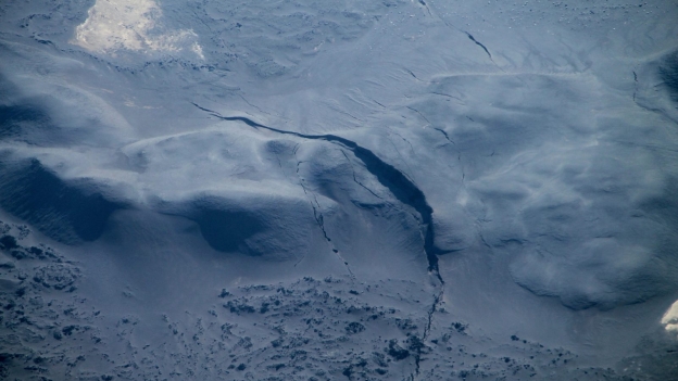
Pretty impressive pictures.
ruv.is...
I used google translator to get a part of it:
Clearly visible cracks appear on the surface blowout lava, north of Dyngjujökul, because swarms corridor there has been replacing its way deep above the ground. Scientists saw the cracks today, in eftirlitsflugi with TF SIF, machine Coast Guard.
edit on 27-8-2014 by Darkblade71
because: (no reason given)
I am watching the live cams,chat and following some of the conversation that is posted on the live screen,
and it is starting to sound like an eruption is under way.
People are just waiting for information.
Or it is another false alarm.
and it is starting to sound like an eruption is under way.
People are just waiting for information.
Or it is another false alarm.
a reply to: Darkblade71
What is the red glow in the center of the screen? I can't make much out until I get to my computer...
What is the red glow in the center of the screen? I can't make much out until I get to my computer...
new topics
-
What is the white pill?
Philosophy and Metaphysics: 46 minutes ago -
Mike Pinder The Moody Blues R.I.P.
Music: 1 hours ago -
Putin, Russia and the Great Architects of the Universe
ATS Skunk Works: 4 hours ago -
A Warning to America: 25 Ways the US is Being Destroyed
New World Order: 9 hours ago
top topics
-
President BIDEN's FBI Raided Donald Trump's Florida Home for OBAMA-NORTH KOREA Documents.
Political Conspiracies: 14 hours ago, 33 flags -
A Warning to America: 25 Ways the US is Being Destroyed
New World Order: 9 hours ago, 17 flags -
Is AI Better Than the Hollywood Elite?
Movies: 16 hours ago, 4 flags -
Mike Pinder The Moody Blues R.I.P.
Music: 1 hours ago, 3 flags -
What is the white pill?
Philosophy and Metaphysics: 46 minutes ago, 3 flags -
Putin, Russia and the Great Architects of the Universe
ATS Skunk Works: 4 hours ago, 2 flags -
Maestro Benedetto
Literature: 16 hours ago, 1 flags
active topics
-
So this is what Hamas considers 'freedom fighting' ...
War On Terrorism • 263 • : ToneD -
What is the white pill?
Philosophy and Metaphysics • 1 • : Astyanax -
Meadows, Giuliani Among 11 Indicted in Arizona in Latest 2020 Election Subversion Case
Mainstream News • 20 • : WeMustCare -
Mood Music Part VI
Music • 3107 • : TheWoker -
A Warning to America: 25 Ways the US is Being Destroyed
New World Order • 21 • : MetalThunder -
Gaza Terrorists Attack US Humanitarian Pier During Construction
Middle East Issues • 63 • : ToneD -
Truth Social goes public, be careful not to lose your money
Mainstream News • 133 • : Astyanax -
New whistleblower Jason Sands speaks on Twitter Spaces last night.
Aliens and UFOs • 70 • : baablacksheep1 -
President BIDEN's FBI Raided Donald Trump's Florida Home for OBAMA-NORTH KOREA Documents.
Political Conspiracies • 27 • : Threadbarer -
Putin, Russia and the Great Architects of the Universe
ATS Skunk Works • 16 • : CristianVictoria