It looks like you're using an Ad Blocker.
Please white-list or disable AboveTopSecret.com in your ad-blocking tool.
Thank you.
Some features of ATS will be disabled while you continue to use an ad-blocker.

NUKE Conspiracy Waveform and Data Analysis - Intelligent Discussion Invitation
page: 1share:
Numerous threads have come and gone regarding the possible detonation of a nuke off of the East Coast of America. It's been done - names have been
been called, fingers pointed and threads closed down because people just can't play nice.
That is not where this thread is intended to go, so bear with me for a minute...
In reading the content of the discussions on this topic, I did however come across some factual data that is very intriguing to me and leaves me with some unanswered questions.
For quite some time now - since the 2008 earthquake swarm at Yellowstone, I have been interested in earthquakes and try to keep abreast of current events regarding them. I'm far, far from being an expert, an authority, or even someone who could be considered to have a large amount of knowledge on the subject.
But...
I do keep a watchful eye on the EQ happenings across the globe and have stared at endless seismograph displays and waveforms with a rudimentary understanding at best. In doing so, I have seen many different waveforms and have tried to understand their significance and differences in appearance.
When the Magnitude 4.4 event occurred on October 8th as seen in the link below, I have to admit that I thought to myself - "Hmm... Odd. I've never seen one in that area before".
USGS Event Data
Then, the conspiracy and all of the threads on the subject followed and I again thought to myself "HMMMMMMM"... (caps and more M's included to emphasize the amount of hmming taking place).
Ok, here's the meat:
Different events have different waveforms and signatures. While it is difficult to determine the origin of a particular event solely based on the 'look' of a waveform, different events do appear differently.
Here are examples of various waveforms:

Source
Now, for an example of a documented Nuclear blast and it's waveform - accompanied by a comparison of an event that was suspected by the U.S. State and Defense Departments as having "explosive characteristics", though according to seismologists, was clearly an earthquake due to various other indicators including location, presence of aftershocks and the examination of the P/S Wave time-delay ratios for the particular event.

Source
As quoted from the article:
Now, lets take a look at the signature for the October 8th 'event':

I have to admit - When I first looked at the webicorder signature, my first thought was "Well Heck Hank, that looks an awful lot like other examples of nuclear test signatures that I have seen". Now after reading the commentary and viewing the examples linked to above, I'm not so sure.
It actually looks more like the example above of the suspected nuclear event that was explained to be an earthquake by those with knowledge of such things.
One thing that still raises an eyebrow is the absence of aftershocks. As quoted above, that was one of the indicators that the event in question was actually an earthquake and not a nuclear test as suspected.
The other indicator was the P-Wave and S-Wave data.
I still just can't quite detach the look of the waveform with it's initial then subsequent rumblings from well - you know...
Now, this is where I turn on the Bat Beacon... Calling all quake gurus! You know who you are!
I would invite any of our numerous quake aficionados to chime in, your input is invaluable. By the same token, I would discourage the kind of speculation and discussion which has shut down the numerous aforementioned threads. Are there any conflicting opinions in your community regarding the October 8th event and it's data or is it pretty cut-and-dry? If so, why? What is the data??
Perhaps a discussion on the P/S intervals would be a good place to start, at which point I'll most likely no longer be able to contribute anything but the sound of gurgling as I try to absorb an inkling of what you're saying.
My intention, is to spark an intelligent debate based on the hard data. Not on anyone's feelings about our fearless leader, what AJ has to say about it, the state of the nation, etc etc etc.
Let's not kill this one too!
You have my opinion on the subject, which again is "HMMMMM".
That's all I got, you may commence...
That is not where this thread is intended to go, so bear with me for a minute...
In reading the content of the discussions on this topic, I did however come across some factual data that is very intriguing to me and leaves me with some unanswered questions.
For quite some time now - since the 2008 earthquake swarm at Yellowstone, I have been interested in earthquakes and try to keep abreast of current events regarding them. I'm far, far from being an expert, an authority, or even someone who could be considered to have a large amount of knowledge on the subject.
But...
I do keep a watchful eye on the EQ happenings across the globe and have stared at endless seismograph displays and waveforms with a rudimentary understanding at best. In doing so, I have seen many different waveforms and have tried to understand their significance and differences in appearance.
When the Magnitude 4.4 event occurred on October 8th as seen in the link below, I have to admit that I thought to myself - "Hmm... Odd. I've never seen one in that area before".
USGS Event Data
Then, the conspiracy and all of the threads on the subject followed and I again thought to myself "HMMMMMMM"... (caps and more M's included to emphasize the amount of hmming taking place).
Ok, here's the meat:
Different events have different waveforms and signatures. While it is difficult to determine the origin of a particular event solely based on the 'look' of a waveform, different events do appear differently.
Here are examples of various waveforms:
Source
Now, for an example of a documented Nuclear blast and it's waveform - accompanied by a comparison of an event that was suspected by the U.S. State and Defense Departments as having "explosive characteristics", though according to seismologists, was clearly an earthquake due to various other indicators including location, presence of aftershocks and the examination of the P/S Wave time-delay ratios for the particular event.
Source
As quoted from the article:
A recent earthquake near a former Soviet nuclear test site has tested mechanisms for monitoring the test-ban treaty. Technical systems passed with flying colours, but relevant US agencies could have done better.
Early on the morning of Saturday 16 August 1997, there was a small seismic event in the Kara Sea, about 100 kilometres from the nuclear test site on the far northern island of Novaya Zemlya now used by Russia for nuclear weapons research (Fig. 1). Within days, seismologists located the event in an area where it could only have been an earthquake. Yet at the end of August, spokesmen for the US State and Defense departments described the event as having "explosive characteristics", and in late September, officials of other US agencies were still characterizing it as "unresolved" (George Ullrich, Defense Special Weapons Agency), or "lending itself to alternative interpretations" (Bob Bell, National Security Council).
These statements suggested that the seismic signals might have been generated, not by an earthquake, but by a nuclear test. Underground nuclear explosions were carried out by the Soviet Union at the Novaya Zemlya test site from 1964 to 1990, but Russia and many other countries signed the Comprehensive Test Ban Treaty (CTBT) in September 1996, thus making a commitment not to carry out nuclear explosive tests for any purpose.
To a seismologist, the evidence is straightforward: the event took place several tens of kilometres offshore to the southeast of Novaya Zemlya, in an area where water depths are around 400 metres. Nuclear explosive testing is not credible in such an ocean environment unless there is other evidence, such as signals from hydroacoustic or radionuclide detectors, or the presence of a vast and complicated drilling operation. The event must therefore have been an earthquake.
Now, lets take a look at the signature for the October 8th 'event':
I have to admit - When I first looked at the webicorder signature, my first thought was "Well Heck Hank, that looks an awful lot like other examples of nuclear test signatures that I have seen". Now after reading the commentary and viewing the examples linked to above, I'm not so sure.
It actually looks more like the example above of the suspected nuclear event that was explained to be an earthquake by those with knowledge of such things.
One thing that still raises an eyebrow is the absence of aftershocks. As quoted above, that was one of the indicators that the event in question was actually an earthquake and not a nuclear test as suspected.
The other indicator was the P-Wave and S-Wave data.
I still just can't quite detach the look of the waveform with it's initial then subsequent rumblings from well - you know...
Now, this is where I turn on the Bat Beacon... Calling all quake gurus! You know who you are!
I would invite any of our numerous quake aficionados to chime in, your input is invaluable. By the same token, I would discourage the kind of speculation and discussion which has shut down the numerous aforementioned threads. Are there any conflicting opinions in your community regarding the October 8th event and it's data or is it pretty cut-and-dry? If so, why? What is the data??
Perhaps a discussion on the P/S intervals would be a good place to start, at which point I'll most likely no longer be able to contribute anything but the sound of gurgling as I try to absorb an inkling of what you're saying.
My intention, is to spark an intelligent debate based on the hard data. Not on anyone's feelings about our fearless leader, what AJ has to say about it, the state of the nation, etc etc etc.
Let's not kill this one too!
You have my opinion on the subject, which again is "HMMMMM".
That's all I got, you may commence...
edit on 23-11-2013 by sageturkey because: Add
edit on 23-11-2013 by sageturkey because:
Title Change

This is a post i put on one of the extracted threads.
I think it was very different from other recorded and documented underwater quakes.
Below taken from another site.
The area where this 4.5 earthquake was recorded, no other earthquake has ever been recorded before.
Inexplicable 4.5 Earthquake in an area that NEVER has earthquakes. 620 miles off of the coast of South Carolina under about a mile of water. A VERY SHALLOW Earthquake in a sand wash.
earthquake-report.com...
The amplitude (Amp) column i would surmise that this quake hit with a bang and then rumbled for 15-20 seconds.
For the sake of argument here is another undersea quake for comparison. this one went "low, quick high then long low" amplitude.
www.emsc-csem.org...
edit on 23-11-2013 by sueloujo because: (no reason given)
reply to post by six67seven
It would if it were current but that map was originally created a year and a half ago...
From the original source...
www.flickr.com...
It would if it were current but that map was originally created a year and a half ago...
Taken on June 25, 2012
From the original source...
www.flickr.com...
reply to post by sueloujo
Very shallow? It was 9 miles deep. That's not deep but it's not very shallow either.
ETA: Nine miles is in the shallow zone for earthquakes, but so are a large number of earthquakes every year. What's different between this one and those?
Very shallow? It was 9 miles deep. That's not deep but it's not very shallow either.
ETA: Nine miles is in the shallow zone for earthquakes, but so are a large number of earthquakes every year. What's different between this one and those?
edit on 11/23/2013 by Zaphod58 because: (no reason given)
reply to post by GAOTU789
Obviously it's not current according to the creation date AND like I mentioned, it doesn't show quakes from 2004 and on. Still, in the 114 years of quakes recorded and shown on the map, there IS NOT ONE in that location. That's the point.
I'm looking for a map of earthquakes over that past 10 years. Odds are the map will show none or one depending on the creation date of said map.
reply to post by six67seven
But there are lots of places that don't have earthquakes, but have them suddenly. They would have had to not only move the nuclear weapon with no one but Alex Jones noticing, they would have had to dig down 9 miles to place it. All without leaving a single seismic signature that they were digging (digging also leaves signatures).
Page 3 shows the seismic signatures of digging using various tools. There should have been some kind of signature of them digging to place the weapon. Where is it?
Ok so if it was a nuke, why?
I don't understand why people "thwarting" a nuke America plan would still detonate at all...
Why not disable all 3 ?
I don't understand why people "thwarting" a nuke America plan would still detonate at all...
Why not disable all 3 ?
sageturkey
Are there any conflicting opinions in your community regarding the October 8th event and it's data or is it pretty cut-and-dry? If so, why? What is the data??
Answer so far is possibly "not enough data".
As seen in the example that you linked to, one of the best methods is to use the frequency analysis data, which for this 2013 event, we do not have.
Furthermore, there is the complicating factor that vertical seismometers give slightly different traces than horizontal traces. Which ones are comparing with? And different mechanical arrangements and siting of seismometers give different traces. You'd really want to see the traces from a number of increasingly distant seismometers.
And also the complicating factor of filters. Earthquakes create waves at short, medium and long wavelengths. A whole bunch. Lots of them. But you can optimise your seismometer for the events you are specifically interested in. eg. People interested in local quakes want short period data, people interested in distant quakes on the other side of the world want long period data.
My own opinion is that without the frequency data, for which you'd need the actual raw data from the seismometer and a program like Amaseis (or is it Winquake that I'm thinking of?) that can separate it out, you could make a case either way with what we have here so far depending on your inclination.
But a depth of 9.3 miles is unlikely to be human made. Who the hell would drill a hole that deep to set off a pointless nuke, and without anybody noticing the drilling equipment?
edit on pmSaturdayfpm1 by alfa1 because: (no reason given)
[1] Lindsey Graham said a nuke would go off in South Carolina if bla bla bla....
[2] Nukes go missing and transported to an unknown location on the east coast.
[3] 2 top high ranking military men in charge of nukes are fired.
[4] A 4.5 [relatively shallow //below 60 KMs] earthquake happens off the coast of South Carolina in an area where quakes almost never happen.
I have been researching engineered quakes for about 3 years.....It looks to me like man made quakes are between 10 and 60 kilometers deep....
The weight of evidence points a nuke going off in the South Caroline business IMHO...
Zaphod58
reply to post by cathar
Then show evidence of then digging down.
The depths of quakes are not always known...in which case a depth is estimated....When you see a quake depth at
10 kilometers it means they don't know the depth...& BTW >>USGS is a government agency...they do what they are told.....There is plenty of evidence that USGS has been under estimating the strength of quakes for the last several years.....
reply to post by cathar
They can measure pretty close where the quake is. Even if they are government agencies, there are others that aren't part of the government that agree with the depth.
They can measure pretty close where the quake is. Even if they are government agencies, there are others that aren't part of the government that agree with the depth.
reply to post by sueloujo
[quote]Inexplicable 4.5 Earthquake in an area that NEVER has earthquakes
Not strictly true. There was a mag 4.6 on 27th December 2007.
ETA: ANSS data for 500km radius search
IEB Map
No, the seismo where this was picked up was a long way from the event and the waveform has been considerably attenuated. At ~1000km it is past the point where it can be considered local and is a teleseism.
Click the image to enlarge
[quote]Inexplicable 4.5 Earthquake in an area that NEVER has earthquakes
Not strictly true. There was a mag 4.6 on 27th December 2007.
ETA: ANSS data for 500km radius search
DateTime,Latitude,Longitude,Depth,Magnitude,MagType,NbStations,Gap,Distance,RMS,Source,EventID
2002/01/12 08:26:52.90,28.2790,-69.5660,10.00,5.40,Mw,429,,,0.85,NEI,2002011240
2002/02/06 04:52:51.02,28.4200,-69.9470,10.00,3.60,Mb,16,,,0.78,NEI,2002020640
2007/12/27 20:51:57.49,27.6790,-71.0760,10.00,4.60,Mb,84,,,1.03,NEI,2007122741
2013/10/08 01:58:09.61,30.1983,-74.0843,14.89,4.40,Mb,,63,5,1.17,us,2013100820
IEB Map
The amplitude (Amp) column i would surmise that this quake hit with a bang and then rumbled for 15-20 seconds.
No, the seismo where this was picked up was a long way from the event and the waveform has been considerably attenuated. At ~1000km it is past the point where it can be considered local and is a teleseism.

Click the image to enlarge
edit on 24/11/2013 by PuterMan because: (no reason given)
reply to post by sageturkey
Reds under the bed! The U.S. Defense Department sees commies and enemies of the State everywhere, even amongst it's own citizens. Do NOT whatever you do show them their own shadow!
As regards this event, consider this.
First the wave form as records at TA.Y60A looks like a teleseism
Click the image to enlarge
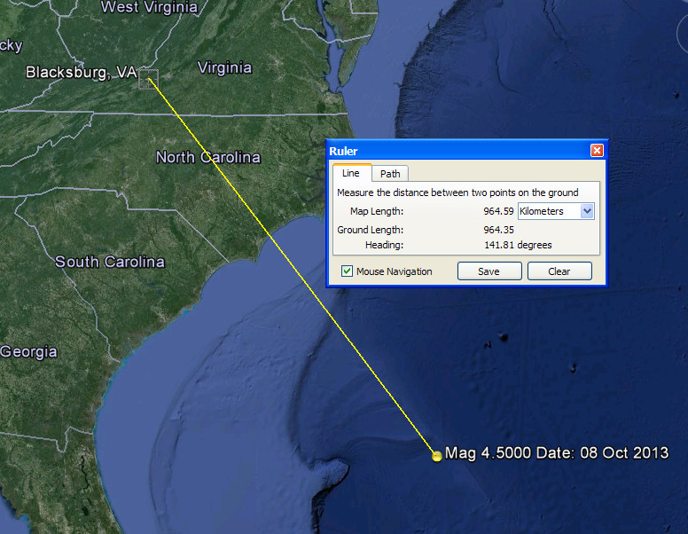
Second consider the depth. 30.198°N 74.084°W depth=14.9km (9.3mi)
Can the Russians really drill down nearly 15 kilometres in nearly 4000 metres of water without being detected by the mightiest Nation on Earth. If it can there is hope for us all yet.
Can the Russians also better the depth of the Kola Superdeep Borehole
That was on land. This event was closer to the hot stuff than the lithospheric block Russia sits on.
There have been longer boreholes since, but.......
If the event had recorded a depth of 1km or so I would grant that there might be some cause for further investigation and conspiracy theorising, but at ~15km it is out of the question that this was a nuke.
accompanied by a comparison of an event that was suspected by the U.S. State and Defense Departments as having "explosive characteristics", though according to seismologists, was clearly an earthquake due to various other indicators including location, presence of aftershocks and the examination of the P/S Wave time-delay ratios for the particular event.
Reds under the bed! The U.S. Defense Department sees commies and enemies of the State everywhere, even amongst it's own citizens. Do NOT whatever you do show them their own shadow!
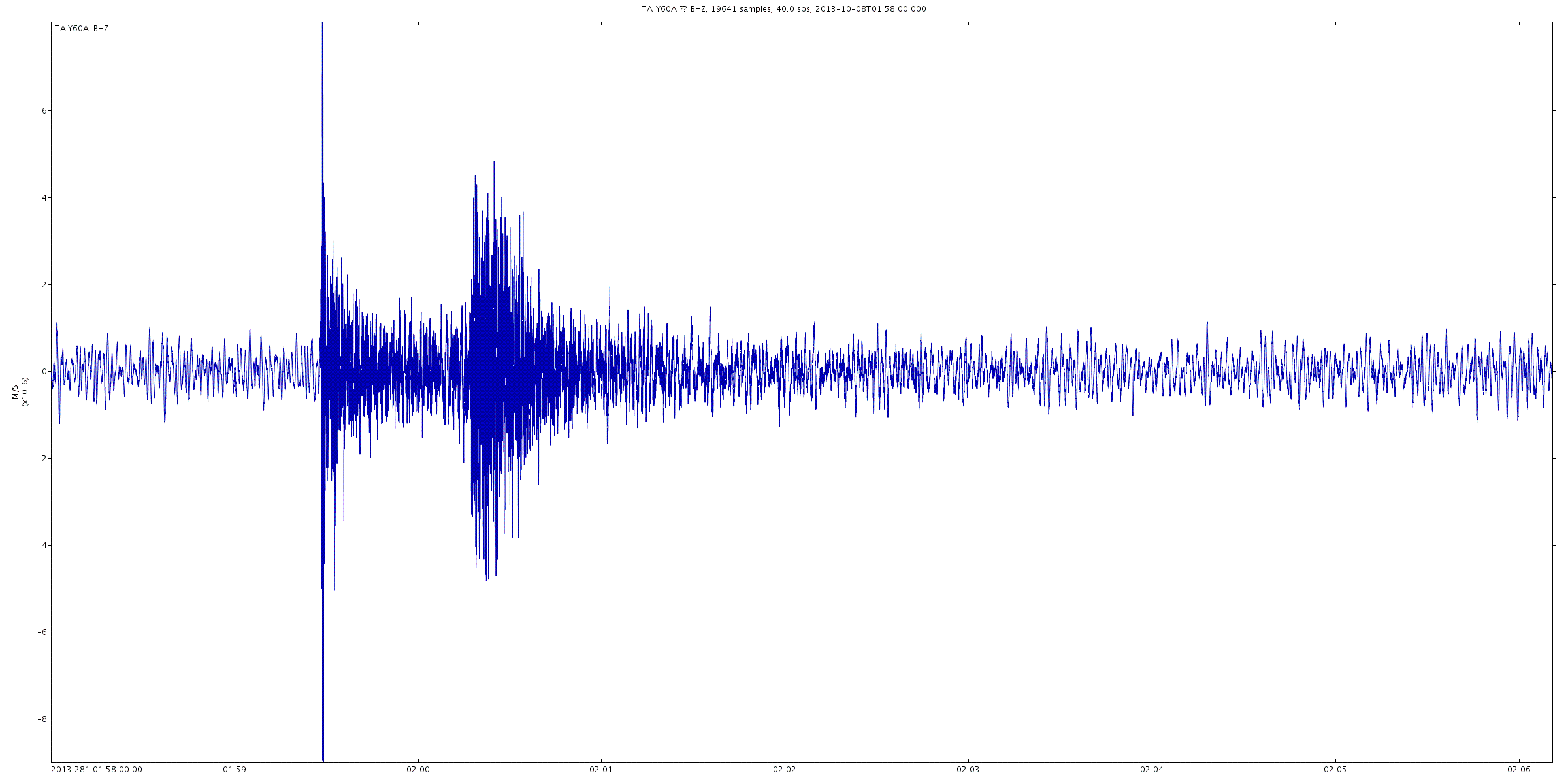
As regards this event, consider this.
First the wave form as records at TA.Y60A looks like a teleseism

Click the image to enlarge
Second consider the depth. 30.198°N 74.084°W depth=14.9km (9.3mi)
Can the Russians really drill down nearly 15 kilometres in nearly 4000 metres of water without being detected by the mightiest Nation on Earth. If it can there is hope for us all yet.
Can the Russians also better the depth of the Kola Superdeep Borehole
However, because of higher-than-expected temperatures at this depth and location, 180 °C (356 °F) instead of expected 100 °C (212 °F), drilling deeper was deemed unfeasible and the drilling was stopped in 1992.[4] With the projected further increase in temperature with increasing depth, drilling to 15,000 m (49,000 ft) would have meant working at a 300 °C (570 °F), where the drill bit would no longer work
That was on land. This event was closer to the hot stuff than the lithospheric block Russia sits on.
The Kola borehole penetrated about a third of the way through the Baltic continental crust, estimated to be around 35 kilometres (22 mi) deep
There have been longer boreholes since, but.......
However, in terms of depth below the surface, the Kola Superdeep Borehole still retains the world record as of November 2013.
If the event had recorded a depth of 1km or so I would grant that there might be some cause for further investigation and conspiracy theorising, but at ~15km it is out of the question that this was a nuke.
edit on 24/11/2013 by PuterMan because: (no reason given)
Zaphod58
reply to post by six67seven
But there are lots of places that don't have earthquakes, but have them suddenly. They would have had to not only move the nuclear weapon with no one but Alex Jones noticing, they would have had to dig down 9 miles to place it. All without leaving a single seismic signature that they were digging (digging also leaves signatures).
Page 3 shows the seismic signatures of digging using various tools. There should have been some kind of signature of them digging to place the weapon. Where is it?
Yes indeed, like the recent Mag 4 off the West coast of Ireland. A single isolated incident. Of course it must have been the Americans testing a nuke.
reply to post by alfa1
You can get the data you require from here as sound files or waveform files or seismograms for a huge range of instruments and channels. The waveform I showed above was unfiltered from TA.Y60A.BHZ, but I could have got it from the other channels or another seismo. That was just the first that came up in the public list.
Here is BHE
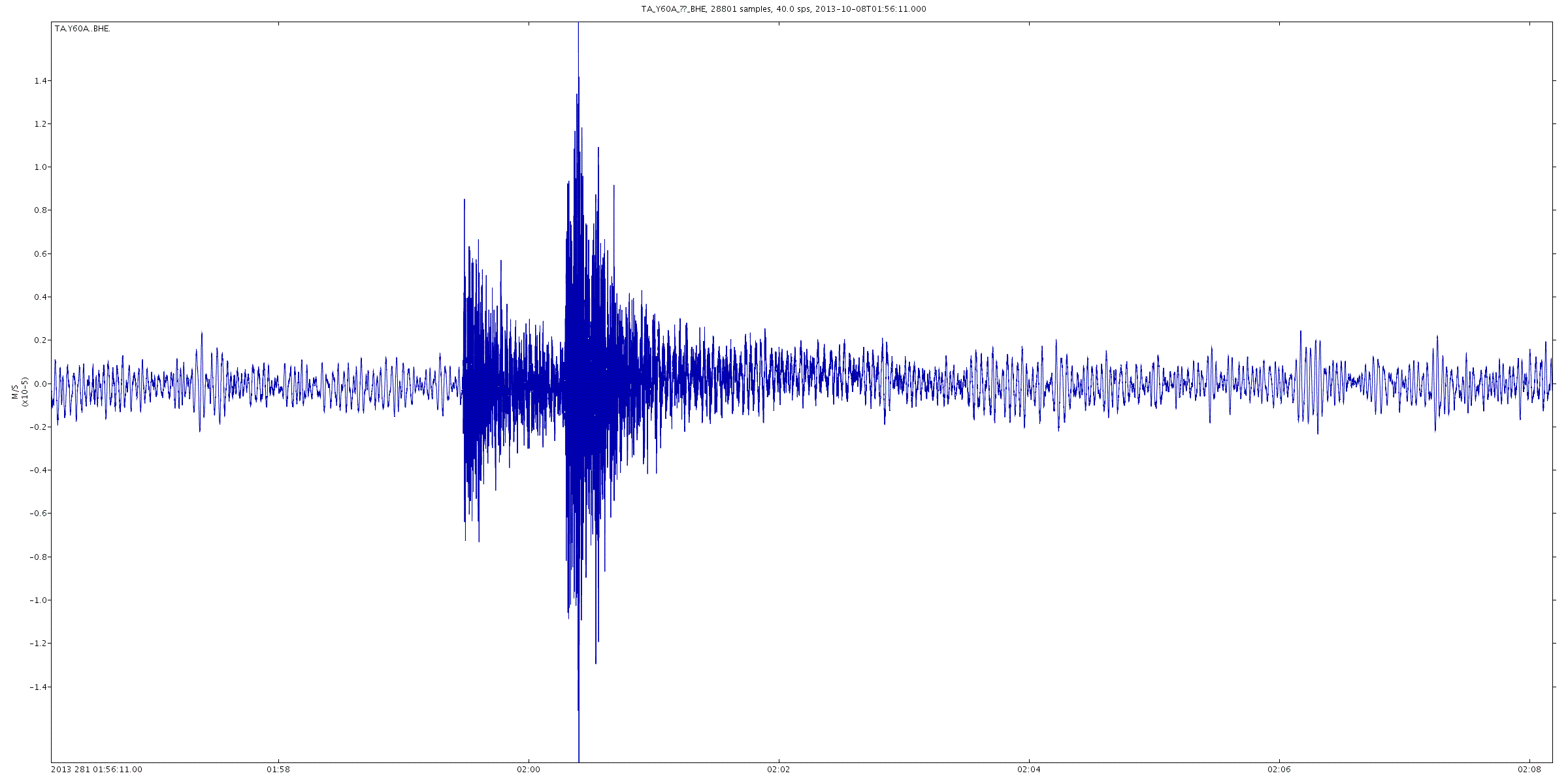
Click the image to enlarge
And BHN
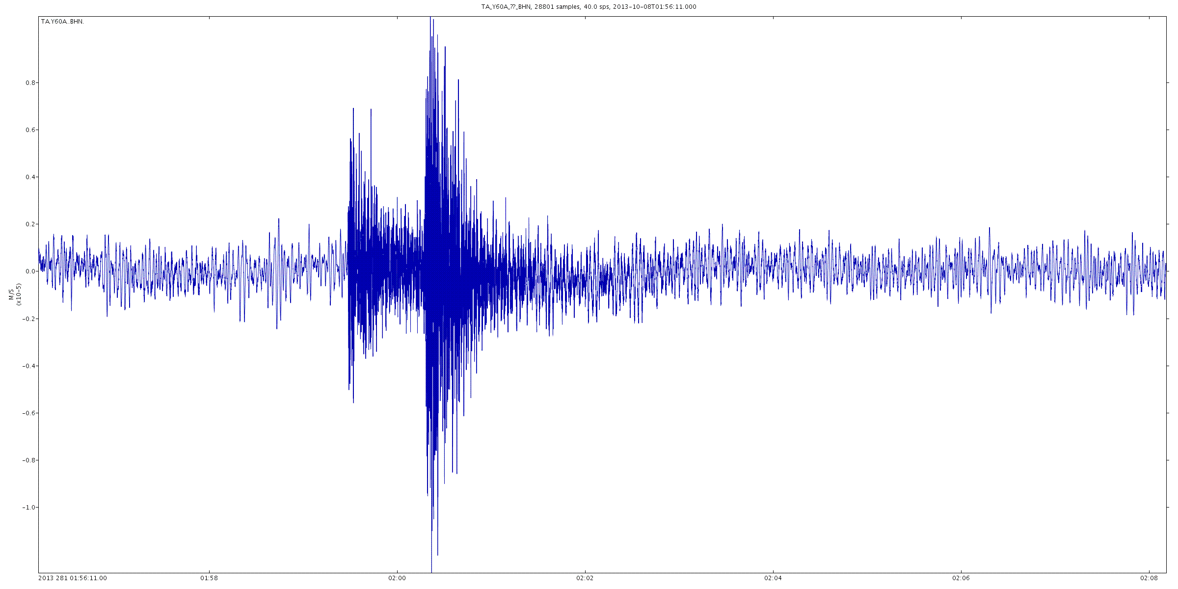
Click the image to enlarge
As seen in the example that you linked to, one of the best methods is to use the frequency analysis data, which for this 2013 event, we do not have.
You can get the data you require from here as sound files or waveform files or seismograms for a huge range of instruments and channels. The waveform I showed above was unfiltered from TA.Y60A.BHZ, but I could have got it from the other channels or another seismo. That was just the first that came up in the public list.
Here is BHE

Click the image to enlarge
And BHN

Click the image to enlarge
edit on 24/11/2013 by PuterMan because: (no reason given)
alfa1
Answer so far is possibly "not enough data".
As seen in the example that you linked to, one of the best methods is to use the frequency analysis data, which for this 2013 event, we do not have.
Thanks for that alfa - I would be interested to see others findings as they sift through the available information and form their postulations.
PuterMan
If the event had recorded a depth of 1km or so I would grant that there might be some cause for further investigation and conspiracy theorising, but at ~15km it is out of the question that this was a nuke.
Thanks PM, so the depth alone pretty much puts it to rest then. I do imagine that there will be those who will some in-depth investigation, making comparisons to past events and what not. Still interested in seeing their conclusions.
On a side note, I'm just happy that my Bat Beacon works. It called-in the big guns!
edit on 24-11-2013 by sageturkey because: Add
cathar
Zaphod58
reply to post by cathar
Then show evidence of then digging down.
The depths of quakes are not always known...in which case a depth is estimated....When you see a quake depth at
10 kilometers it means they don't know the depth...& BTW >>USGS is a government agency...they do what they are told.....There is plenty of evidence that USGS has been under estimating the strength of quakes for the last several years.....
Thanks for this post Cathar. These were the same questions I was about to ask. I was wondering if there is any other source for the depth of this quake other than the USGS.
reply to post by Rezlooper
EMSC have the quake at the original depth of 48km. USGS originally had 48.22km but changed it since.
EMSC have the quake at the original depth of 48km. USGS originally had 48.22km but changed it since.
new topics
-
Rainbow : Stargazer
Music: 9 minutes ago -
I sleep no more.
Philosophy and Metaphysics: 2 hours ago -
Canada caught red-handed manipulating live weather data and make it warmer
Fragile Earth: 2 hours ago -
Why Files Our Alien Overlords | How We Secretly Serve The Tall Whites
Aliens and UFOs: 4 hours ago -
Curse of King Tuts Tomb Solved
Ancient & Lost Civilizations: 5 hours ago -
What allies does Trump have in the world?
ATS Skunk Works: 5 hours ago
top topics
-
BIDEN Admin Begins Planning For January 2025 Transition to a New President - Today is 4.26.2024.
2024 Elections: 14 hours ago, 10 flags -
Canada caught red-handed manipulating live weather data and make it warmer
Fragile Earth: 2 hours ago, 10 flags -
Big Storms
Fragile Earth: 15 hours ago, 9 flags -
Why Files Our Alien Overlords | How We Secretly Serve The Tall Whites
Aliens and UFOs: 4 hours ago, 8 flags -
Curse of King Tuts Tomb Solved
Ancient & Lost Civilizations: 5 hours ago, 6 flags -
What allies does Trump have in the world?
ATS Skunk Works: 5 hours ago, 3 flags -
I sleep no more.
Philosophy and Metaphysics: 2 hours ago, 1 flags -
Rainbow : Stargazer
Music: 9 minutes ago, 0 flags
active topics
-
University of Texas Instantly Shuts Down Anti Israel Protests
Education and Media • 341 • : CriticalStinker -
So this is what Hamas considers 'freedom fighting' ...
War On Terrorism • 273 • : YourFaceAgain -
Rainbow : Stargazer
Music • 0 • : gortex -
I sleep no more.
Philosophy and Metaphysics • 4 • : Disgusted123 -
Gov Kristi Noem Shot and Killed "Less Than Worthless Dog" and a 'Smelly Goat
2024 Elections • 81 • : YourFaceAgain -
Krystalnacht on today's most elite Universities?
Social Issues and Civil Unrest • 19 • : TheWoker -
Hate makes for strange bedfellows
US Political Madness • 56 • : YourFaceAgain -
Do you ever just get "bored" of everything?
Rant • 23 • : FlyersFan -
Mood Music Part VI
Music • 3119 • : TheWoker -
"We're All Hamas" Heard at Columbia University Protests
Social Issues and Civil Unrest • 301 • : TheWoker