It looks like you're using an Ad Blocker.
Please white-list or disable AboveTopSecret.com in your ad-blocking tool.
Thank you.
Some features of ATS will be disabled while you continue to use an ad-blocker.

SEVERE WEATHER ALERT - Tornado Outbreak Possible in Midwest U.S
page: 1share:
Powerful Midwest storm
threatens severe tornadoes, damaging winds
Be safe to Everyone in it's path!
- Updates will follow.
www.spc.noaa.gov...
usnews.nbcnews.com...
A powerful storm system will bring tornadoes and widespread damaging wind gusts to many areas of the Midwest Sunday, with millions of Americans in its path, the Weather Channel forecasters said.
Parts of the Great Lakes, Ohio Valley, lower-middle Mississippi Valley and Tennessee Valley are among the areas most at risk for widespread damaging winds and possible tornadoes,
Be safe to Everyone in it's path!
- Updates will follow.
www.spc.noaa.gov...
edit on 17-11-2013 by iunlimited491 because: (no reason given)
Thank you for the warning, I hope everyone will be ok.
Be safe everyone and look out for each other.
Be safe everyone and look out for each other.
reply to post by iunlimited491
Getting pretty dark here in the middle of hellinois. Weather channel just said 80mph winds expected.
The good news????? It's 70 fricking degrees!
Off to do some yard work. I'll snap some pics if it gets ugly.
Getting pretty dark here in the middle of hellinois. Weather channel just said 80mph winds expected.
The good news????? It's 70 fricking degrees!
Off to do some yard work. I'll snap some pics if it gets ugly.
reply to post by KawRider9
Crazy weather we're having lately...
I wish you the best of luck.
Stay safe and enjoy the outside weather while you can!
Crazy weather we're having lately...
I wish you the best of luck.
Stay safe and enjoy the outside weather while you can!
edit on 17-11-2013 by Quyll because: addition
Lots of high wind gusts and ominous looking clouds passing through Mo. since before dawn this am. These rolling thunder clouds were moving so fast my
first thought was for the States to our east who will see these high winds and clouds meet with dangerous effects.
Stay tuned to your local weather authorities and of course here for any updates as this weather anomaly is sure to wreak havoc on hundreds of thousands of households in the next 24 hours. It seems to be moving fast so take heed and get to your shelters ahead of the warnings if you have one, if not find a safe place to wait this out.
1. have water and food at ready, things like sandwiches and such for power outages.
2. remember your neighbors especially those with limited mobility and or other wise vulnerable.
3. remember pets need to be kept safe too!
4. stay tuned to your local weather and take shelter at the first sign of danger.
5.do not play it brave or think that you can stay outside in these winds to catch on video or to become the next youtube sensation with home video footage. Leave the filming to the storm chasers and experts.
6. remember that this is a fast moving and very dangerous situation that you can survive if you stay calm, follow orders from the authorities and your own intuition.
reply to post by iunlimited491
I heard it's been cold throughout the region this week but going up to the mid or high 60s today - and with these high winds it's a perfect day to open the windows and air out houses and apartments. Just tie down the papers and the cats.
I heard it's been cold throughout the region this week but going up to the mid or high 60s today - and with these high winds it's a perfect day to open the windows and air out houses and apartments. Just tie down the papers and the cats.
Spoke with friends in Bowling Green, said it was just getting ready to hit them hard.
For anyone interested in following the storm, see link below.
Kentucky Weather Center
To all in the path -- stay safe
For anyone interested in following the storm, see link below.
Kentucky Weather Center
To all in the path -- stay safe
edit on 17-11-2013 by MrLimpet because: (no reason given)
reply to post by antar
Yeah I live about 5 minutes north of the border between Indiana and Michigan. It's gonna be a good one.
Thats Michigan weather for ya. Thunderstorms and possible tornadoes with less than 2 weeks until December.
i remember having 3 or 4 snow days already by this time of the year when I went to grade school.
reply to post by Aleister
That was my concern early this am, that 'if' the winds and clouds coming up from the southwest were to meet a warm front, big time danger was ahead, if it were to hit a cold front it could be dangerous with straightline winds but not as deadly as in funnel clouds when it meets a warmer front.
That was my concern early this am, that 'if' the winds and clouds coming up from the southwest were to meet a warm front, big time danger was ahead, if it were to hit a cold front it could be dangerous with straightline winds but not as deadly as in funnel clouds when it meets a warmer front.
reply to post by cconn487
Do you get the lake affects? These storm clouds and high winds could potentially become hurricane strength in that case.
Do you get the lake affects? These storm clouds and high winds could potentially become hurricane strength in that case.
TORNADO warming for racine, kenosha, SE walworth counties until 10:30AM. Plz RT! #swiwx
www.tornadoalleylive.com...
www.tornadoalleylive.com...
Inc claims of HAARP!
Thanks for posting, anyone in or near those area please be safe if severe weather does occur.
Thanks for posting, anyone in or near those area please be safe if severe weather does occur.
reply to post by cconn487
With the old patterns of prevailing winds something like this could have been your first blizzard in the olden days, lol! I am not implying that you are old, just what we knew even 20 years ago has become extinct.
With the old patterns of prevailing winds something like this could have been your first blizzard in the olden days, lol! I am not implying that you are old, just what we knew even 20 years ago has become extinct.
antar
reply to post by cconn487
Do you get the lake affects? These storm clouds and high winds could potentially become hurricane strength in that case.
Yeah we get lake effect all the time here. Haven't had any real bad storms recently. Neither rain nor snow. Last March it was in the high 80s which was just weird no matter how you look at it lol.
antar
reply to post by cconn487
With the old patterns of prevailing winds something like this could have been your first blizzard in the olden days, lol! I am not implying that you are old, just what we knew even 20 years ago has become extinct.
Haha yeah. I'm 27 now. There have been a few bigger storms that have done their share of damage over the years. It has been awhile though.
Its about that time
Be sure to stay up to date on any watches/warning as this system continues to move through the region, especially if you're in the affected areas:
www.nws.noaa.gov...
Thanks to all for contributing so far.
www.nws.noaa.gov...
Thanks to all for contributing so far.
edit on 17-11-2013 by iunlimited491 because: (no reason given)
reply to post by iunlimited491
I'm just south of Chicago right in the "danger" zone for the storm, I'll make sure to let you all know how it goes once it intensifies (I believe around 12:30-1pm CST).... Hopefully, there are no tornado touchdowns... Be safe everyone!
I'm just south of Chicago right in the "danger" zone for the storm, I'll make sure to let you all know how it goes once it intensifies (I believe around 12:30-1pm CST).... Hopefully, there are no tornado touchdowns... Be safe everyone!
here's storm chaser TV
www.chasertv.com...
a wind map
hint.fm...
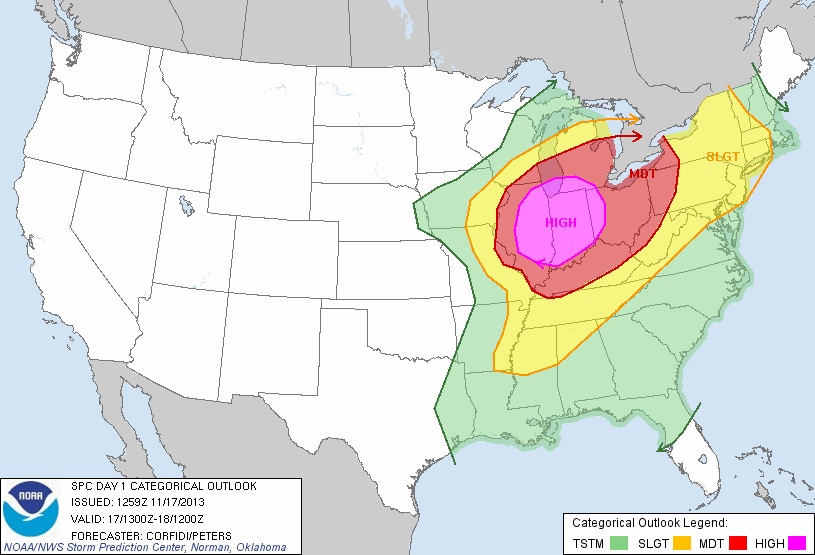
the NOAA watch boxes
www.spc.noaa.gov...
pretty bizarre for november, although there have been big storms before....just not sure there's been tornado warning this late this far north
www.spc.noaa.gov...
Stay Safe, All!!!!!!!!!!!!!
www.chasertv.com...
a wind map
hint.fm...
the NOAA watch boxes
www.spc.noaa.gov...
pretty bizarre for november, although there have been big storms before....just not sure there's been tornado warning this late this far north
www.spc.noaa.gov...
Stay Safe, All!!!!!!!!!!!!!
new topics
-
Mike Pinder The Moody Blues R.I.P.
Music: 35 minutes ago -
Putin, Russia and the Great Architects of the Universe
ATS Skunk Works: 3 hours ago -
A Warning to America: 25 Ways the US is Being Destroyed
New World Order: 8 hours ago
top topics
-
President BIDEN's FBI Raided Donald Trump's Florida Home for OBAMA-NORTH KOREA Documents.
Political Conspiracies: 13 hours ago, 31 flags -
A Warning to America: 25 Ways the US is Being Destroyed
New World Order: 8 hours ago, 13 flags -
Is AI Better Than the Hollywood Elite?
Movies: 15 hours ago, 4 flags -
Mike Pinder The Moody Blues R.I.P.
Music: 35 minutes ago, 2 flags -
Maestro Benedetto
Literature: 15 hours ago, 1 flags -
Putin, Russia and the Great Architects of the Universe
ATS Skunk Works: 3 hours ago, 1 flags
active topics
-
Putin, Russia and the Great Architects of the Universe
ATS Skunk Works • 13 • : CriticalStinker -
Alternate Electors vs Fake Electors - What is the Difference.
2024 Elections • 120 • : Threadbarer -
Gaza Terrorists Attack US Humanitarian Pier During Construction
Middle East Issues • 58 • : matafuchs -
Truth Social goes public, be careful not to lose your money
Mainstream News • 132 • : matafuchs -
New whistleblower Jason Sands speaks on Twitter Spaces last night.
Aliens and UFOs • 67 • : Ophiuchus1 -
Mike Pinder The Moody Blues R.I.P.
Music • 1 • : RussianTroll -
Mood Music Part VI
Music • 3106 • : TheWoker -
University of Texas Instantly Shuts Down Anti Israel Protests
Education and Media • 275 • : Vermilion -
President BIDEN's FBI Raided Donald Trump's Florida Home for OBAMA-NORTH KOREA Documents.
Political Conspiracies • 22 • : 320MPH -
A Warning to America: 25 Ways the US is Being Destroyed
New World Order • 19 • : Cvastar