It looks like you're using an Ad Blocker.
Please white-list or disable AboveTopSecret.com in your ad-blocking tool.
Thank you.
Some features of ATS will be disabled while you continue to use an ad-blocker.

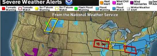
Derecho Risk from Midwest to the Ohio Valley TODAY June 12 2013
page: 2share:
NOAA
URGENT - IMMEDIATE BROADCAST REQUESTED TORNADO WATCH NUMBER 298 NWS STORM PREDICTION CENTER NORMAN OK 150 PM CDT WED JUN 12 2013 THE NWS STORM PREDICTION CENTER HAS ISSUED A * TORNADO WATCH FOR PORTIONS OF NORTHEAST IOWA NORTHERN ILLINOIS EXTREME SOUTHEAST MINNESOTA SOUTHWEST WISCONSIN * EFFECTIVE THIS WEDNESDAY AFTERNOON AND EVENING FROM 150 PM UNTIL 900 PM CDT. ...THIS IS A PARTICULARLY DANGEROUS SITUATION...
* PRIMARY THREATS INCLUDE... SEVERAL INTENSE TORNADOES LIKELY SEVERAL SIGNIFICANT DAMAGING WIND GUSTS TO 80 MPH POSSIBLE SEVERAL VERY LARGE HAIL EVENTS TO 3 INCHES IN DIAMETER POSSIBLE THE TORNADO WATCH AREA IS APPROXIMATELY ALONG AND 65 STATUTE MILES EITHER SIDE OF A LINE FROM 35 MILES WEST SOUTHWEST OF MASON CITY IOWA TO 20 MILES EAST SOUTHEAST OF ROCKFORD ILLINOIS. FOR A COMPLETE DEPICTION OF THE WATCH SEE THE ASSOCIATED WATCH OUTLINE UPDATE (WOUS64 KWNS WOU8). PRECAUTIONARY/PREPAREDNESS ACTIONS... REMEMBER...A TORNADO WATCH MEANS CONDITIONS ARE FAVORABLE FOR TORNADOES AND SEVERE THUNDERSTORMS IN AND CLOSE TO THE WATCH AREA. PERSONS IN THESE AREAS SHOULD BE ON THE LOOKOUT FOR THREATENING WEATHER CONDITIONS AND LISTEN FOR LATER STATEMENTS AND POSSIBLE WARNINGS. && DISCUSSION...POTENTIALLY EXPLOSIVE THUNDERSTORM DEVELOPMENT IS POSSIBLE OVER THE NEXT FEW HOURS AS GRADUALLY DEEPENING SURFACE LOW TRACKS EAST ALONG A FRONTAL ZONE SITUATED FROM NORTHEAST IOWA EASTWARD ALONG THE WI/IL BORDER TO LAKE MICHIGAN. A VOLATILE WARM AND VERY MOIST AIRMASS SHOULD FUEL INTENSE THUNDERSTORM UPDRAFTS ACROSS THESE AREAS WHERE MID LEVEL FLOW IN EXCESS AROUND 50KT SUPPORTS UPDRAFT PERSISTENCE AND ORGANIZATION. A NUMBER OF SUPERCELLS ARE EXPECTED PRIOR TO A CONSOLIDATION OF STORMS INTO A LARGE MCS TOWARD EVENING. LOW LEVEL SHEAR/HELICITY NEAR THE SURFACE LOW AND ALONG THE FRONT WILL SUPPORT SOME TORNADOES WITH ANY DISCRETE CELLS. A COUPLE STRONG TORNADOES SEEM POSSIBLE WITHIN THIS ENVIRONMENT OVER THE NEXT SEVERAL HOURS IN ADDITION TO VERY LARGE HAIL AND LOCALIZED DOWNDRAFT/DAMAGING WIND THREATS. AVIATION...TORNADOES AND A FEW SEVERE THUNDERSTORMS WITH HAIL SURFACE AND ALOFT TO 3 INCHES. EXTREME TURBULENCE AND SURFACE WIND GUSTS TO 70 KNOTS. A FEW CUMULONIMBI WITH MAXIMUM TOPS TO 550. MEAN STORM MOTION VECTOR 28030.
Originally posted by daryllyn
I am right in the path of this thing and we had a similar storm around this same time last year.
Some were without power for three weeks, we had to go out of state to get gas and ice, it was bad. The red cross even made an appearance. The damage was extensive.
It was NO joke.
We ran from that storm in the car, so I'm obviously extra anxious this time around.
We feel more prepared this time.
To all who will potentially be affected, go get some gas and groceries, get your coolers ready, and find somewhere safe to go ASAP if you don't have proper shelter, and stay safe!
Hey there sweety, just chiming in. Yea I was in that one too, central ohio. We were without power for a week, so I hooked my car up to the house via power inverter - buy one lol. What was crazy is it brought the neighborhood together, something you dont see too much these days. Stock up on candles and liqour!
reply to post by whatnext21
Thanks for making this thread... I was gonna due it as I'm on the Southside of Chicago and I'm getting ready to race home from work at 5....
Note: You couldn't tell by looking outside that this storm was coming... It's sunny and beautiful... Minus the occasional sun sprinkle...
Just wanted to say; anyone in the Severe Area~ Please stay safe! Please be careful! And God Speed~
This is sulaw signing out~
Chicago here too... just brought my seedlings in, since I already had one crop blow away in the high winds a few weeks ago
I'll try to capture any wicked storm activity if it comes this way! Careful people. Currently a tornado warning for the Sandwich, IL area...
I'll try to capture any wicked storm activity if it comes this way! Careful people. Currently a tornado warning for the Sandwich, IL area...
Milwaukee area checking in. I have a feeling we are going to get some strong storms today you can feel it in the air.
Hopefully my seedlings do not get blown away.
:up
Also I really good radar sight is storm chaser-storm tracker sight. It shows all of the current storm chasers with cam feeds. The best radar I have found yet.
Hopefully my seedlings do not get blown away.
:up
Also I really good radar sight is storm chaser-storm tracker sight. It shows all of the current storm chasers with cam feeds. The best radar I have found yet.
edit on 12-6-2013 by SubTruth because: (no reason given)
Chasers Live Link
The Chasers are in the area, many to chose from
Watching Shawn Brown and he has reported a rotating Wall Cloud and is west of Yorkville Illinois (correction), very windy and raining there. Things could have changed by the time this is posted, not sure how delayed the video is. The video keeps freezing so you have to keep trying to get a feed.
edit on 12-6-2013 by whatnext21 because: new info
edit on 12-6-2013 by whatnext21 because: (no reason given)
Chicago suburbs here. Last year was bad. Branches down everywhere,no power for three days and it looked like someone shot my A/C unit with a shotgun
from the hail coming in sideways. Not looking forward to this again. Stay safe.
Shabona Illinois is reporting tree limbs and power lines down (a lot) and Sandwich Illinois is reporting 65 mph winds and 1" hail is reported SE of
Sublette, not sure if these are right or not?.
on Chaser TV Live click on any icons that pop up on the map for details
Lots of info coming in where the icons are, too many to list, reports of rope tornadoes being obscured by rain by a trained spotter NW of Hampton in Franklin County, Iowa?
on Chaser TV Live click on any icons that pop up on the map for details
Lots of info coming in where the icons are, too many to list, reports of rope tornadoes being obscured by rain by a trained spotter NW of Hampton in Franklin County, Iowa?
edit on 12-6-2013 by whatnext21 because: (no reason given)
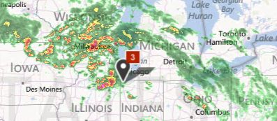
Tornado warning siren triggered and then ended as the thunder started in the Joliet area. Now experiencing heavy rain.
I'm not wishing for a tornado or any harm to people, But wind and hail is good for business to me.
I'm in Central Illinois. Looks like I better get the generator gassed up and ready to go. Might as well go ahead and get the coffee pot set up too.
It may be a loooong night.
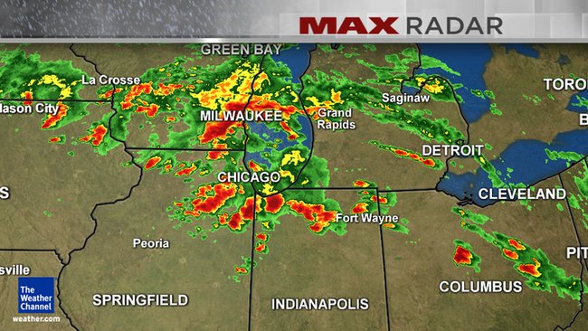
this is definitely a nasty storm system, folks. where i live in the detroit area has been at a 5% tornado risk, since this morning....don't let that
fool you.....i've seen tornadoes pop up in lesser risk areas. if anyone is in the path of any of these storms, keep a close eye to the sky, and hope
you can hear the sirens blasting if something does hit your area. as a trained spotter, 2 good programs to invest in are Interwarn and GRLevel3.
Interwarn basically gives you direct info from the NWS....including warnings, severe weather outlooks, and a lot more. GRLevel3 is a great radar
program.....i invested in both a year ago, and have no regrets.
BULLETIN - EAS ACTIVATION REQUESTED TORNADO WARNING NATIONAL WEATHER SERVICE PITTSBURGH PA 918 PM EDT WED JUN 12 2013
THE NATIONAL WEATHER SERVICE IN PITTSBURGH HAS ISSUED A * TORNADO WARNING FOR...
CENTRAL GUERNSEY COUNTY IN EAST CENTRAL OHIO...
NORTHEASTERN NOBLE COUNTY IN EAST CENTRAL OHIO...
* UNTIL 945 PM EDT * AT 917 PM EDT...
A SEVERE THUNDERSTORM CAPABLE OF PRODUCING A TORNADO WAS NEAR SALT FORK STATE PARK...AND WAS MOVING SOUTHEAST AT 30 MPH.
* LOCATIONS IMPACTED INCLUDE... SALT FORK STATE PARK...
OLD WASHINGTON... SENECAVILLE... SENECA LAKE PARK... QUAKER CITY...
PRECAUTIONARY/PREPAREDNESS ACTIONS...
MOVE TO A BASEMENT OR AN INTERIOR ROOM ON THE LOWEST FLOOR OF A STURDY BUILDING. AVOID WINDOWS. IN ADDITION...HAIL GREATER THAN 1.00 INCH IS POSSIBLE.
It's definitely a strong system; several clusters of storms are capable of producing a tornado.
Being a derecho , - it's bound to move quickly.
As of right now, tomorrow is expected to be more of the same thing.
The first line of severe thunderstorms could even reach some parts of the East coast later on tonight.
Though the primary threat will be tomorrow afternoon.
The storm is on an SE trajectory.
Areas currently in the threat zone for tomorrow include New Jersey, and everywhere south.
As mentioned, not only are these storms dangerous -
But the entire system consists of several intense clusters,
some areas probably seeing one right after an other.
I'll be paying attention to the updates.
S&F.
Originally posted by whatnext21
Shabona Illinois is reporting tree limbs and power lines down (a lot) and Sandwich Illinois is reporting 65 mph winds and 1" hail is reported SE of Sublette, not sure if these are right or not?.
We had a reported touchdown in Somonauk, but the damage appears to be limited to shorn trees and wind blown debris. The golf ball sized hail is what finally convinced me to grab the dog and go hang out in the basement for awhile.
As far as storms go, there wasn't substantial damage. I think the reason for the hype is the sheer number of people that could potentially be affected. Southern DeKalb County is rural by anyone's description, but they had these storms tracking through Chicago to Pittsburgh. Some great pics showing up on NSABook though.
Grew up in Shabbona, currently live in Somonauk, and it's a bit surreal to see the old stomping grounds mentioned on ATS!
www.daily-chronicle.com...
edit on 13-6-2013 by usmconslaught because: (no
reason given)
I just checked the radar and there's a well-defined squall line moving through Pennsylvania, Maryland, West Virginia and Virginia right now.
www.accuweather.com...
www.accuweather.com...
edit on 13-6-2013 by Junkheap because: (no reason given)
new topics
-
What is the white pill?
Philosophy and Metaphysics: 1 hours ago -
Mike Pinder The Moody Blues R.I.P.
Music: 2 hours ago -
Putin, Russia and the Great Architects of the Universe
ATS Skunk Works: 5 hours ago -
A Warning to America: 25 Ways the US is Being Destroyed
New World Order: 9 hours ago
top topics
-
President BIDEN's FBI Raided Donald Trump's Florida Home for OBAMA-NORTH KOREA Documents.
Political Conspiracies: 15 hours ago, 34 flags -
A Warning to America: 25 Ways the US is Being Destroyed
New World Order: 9 hours ago, 18 flags -
Mike Pinder The Moody Blues R.I.P.
Music: 2 hours ago, 5 flags -
Is AI Better Than the Hollywood Elite?
Movies: 17 hours ago, 4 flags -
What is the white pill?
Philosophy and Metaphysics: 1 hours ago, 4 flags -
Putin, Russia and the Great Architects of the Universe
ATS Skunk Works: 5 hours ago, 2 flags -
Maestro Benedetto
Literature: 16 hours ago, 1 flags
active topics
-
Starburst galaxy M82 - Webb Vs Hubble
Space Exploration • 8 • : Justoneman -
God's Righteousness is Greater than Our Wrath
Religion, Faith, And Theology • 34 • : andy06shake -
A Warning to America: 25 Ways the US is Being Destroyed
New World Order • 22 • : charlest2 -
Las Vegas UFO Spotting Teen Traumatized by Demon Creature in Backyard
Aliens and UFOs • 14 • : pianopraze -
Gaza Terrorists Attack US Humanitarian Pier During Construction
Middle East Issues • 73 • : FlyersFan -
SETI chief says US has no evidence for alien technology. 'And we never have'
Aliens and UFOs • 76 • : andy06shake -
Russia Ukraine Update Thread - part 3
World War Three • 5734 • : Arbitrageur -
So this is what Hamas considers 'freedom fighting' ...
War On Terrorism • 264 • : FlyersFan -
Candidate TRUMP Now Has Crazy Judge JUAN MERCHAN After Him - The Stormy Daniels Hush-Money Case.
Political Conspiracies • 792 • : Threadbarer -
What is the white pill?
Philosophy and Metaphysics • 6 • : kwaka