It looks like you're using an Ad Blocker.
Please white-list or disable AboveTopSecret.com in your ad-blocking tool.
Thank you.
Some features of ATS will be disabled while you continue to use an ad-blocker.

Oddity on Google Mars?
page: 4share:
Originally posted by rdunk
reply to post by wmd_2008
Same way as kako187 did it just above. Just went to Google Mars and used the same measuring tool. Kako measured the dia., and I measured the length.edit on 15-4-2013 by rdunk because: correction
Care to indicate what you think is 2 miles long
Originally posted by WanderingThe3rd
reply to post by MysticEngineer
I don't mean to poop on your party, I'd like to find something crazy on Mars too!
edit on 14-4-2013 by HairlessApe because: (no reason given)
Okay, then perhaps you can tell me what this is?
www.hiddenmars.com...
It's Aram Chaos. en.wikipedia.org...
What do you expect from a place called chaos? But anyway, it sits between valles marineris and the "lower" lands, it was a flooded/wet terrain on martian past greatly shaped by flowing liquid and wind.
edit on 15-4-2013 by MysticEngineer because: (no reason given)
reply to post by wmd_2008 -Care to indicate what you think is 2 miles long
Sure, I am glad to. As I said, I am using the same Google Mars image for measurement, as did kako187, in his reply today at 2:31PM. The Google Mars image is pretty much the same as the posted HRSC images.
I hope this helps you wmd_2008!!
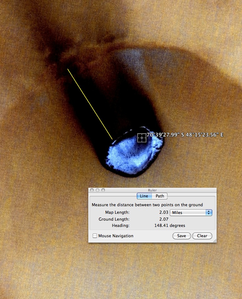
Sure, I am glad to. As I said, I am using the same Google Mars image for measurement, as did kako187, in his reply today at 2:31PM. The Google Mars image is pretty much the same as the posted HRSC images.
I hope this helps you wmd_2008!!
edit on 15-4-2013 by rdunk because: correct attach.
reply to post by rdunk
Except all you did was measure a shadow
The object in the crater at 5m/pixel with the sun at a different angle your image is 12.5m/pixel
viewer.mars.asu.edu...
Hope this helps you rdunk
Except all you did was measure a shadow
The object in the crater at 5m/pixel with the sun at a different angle your image is 12.5m/pixel
viewer.mars.asu.edu...
Hope this helps you rdunk
reply to post by Cynicaleye
They look like tunnel openings revealing a reflective inner planet. The marking that look like trails behind are scatter left from digging out the holes. Of course, I'm sure they are something else.
They look like tunnel openings revealing a reflective inner planet. The marking that look like trails behind are scatter left from digging out the holes. Of course, I'm sure they are something else.
edit on 16-4-2013 by newcovenant because: (no reason given)
Originally posted by eisegesis
Hi-Res Link
Still looking into this...but here is a similiar picture.
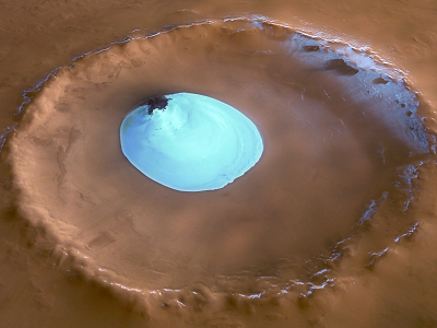
This looks like an ice cap and icy debris around the top of the crater. Possible the others could be a reflective ice formation....I don't know but they are interesting. Sure we'll hear some explanation soon.
Originally posted by newcovenant
reply to post by Cynicaleye
They look like tunnel openings revealing a reflective inner planet. The marking that look like trails behind are scatter left from digging out the holes. Of course, I'm sure they are something else.edit on 16-4-2013 by newcovenant because: (no reason given)
You are joking I hope because look at the images above your post!!!
reply to post by Cynicaleye
Cynicaleye, nice find it does appear to be beneath somewhat. I say this because of how compared to EA*RTH impacts it didn't seem to move the surface around or in front beside it. Maybe the debris or particle fallout/trail are actually radioactive signatures or something not understood here waves being detected from beneath or above the surface of the object somehow by Google.
It would be odd for Google to pick up as 1 would think it the Google imager would not be fit with the outside of general population scan -share- devices (or high tech scan devices for general public use) as those high tech scan devices if present 1 would feel belong to EA*RTH / COSMIC military or related militaries etc. for observational use. 1 does enjoy the image non the less OP and thanks for the share. Still seems somehow to be emitting these rays from beneath and the Google imager detected it by accident like a ray or beam hit the imager by accident to reveal like it went over an area of concentrated waves. Maybe the whole Crater is interesting... beneath.
NAMASTE*******
Originally posted by Ophiuchus 13
reply to post by Cynicaleye
It would be odd for Google to pick up as 1 would think it the Google imager would not be fit with the outside of general population scan -share- devices (or high tech scan devices for general public use) as those high tech scan devices if present 1 would feel belong to EA*RTH / COSMIC military or related militaries etc. for observational use. 1 does enjoy the image non the less OP and thanks for the share. Still seems somehow to be emitting these rays from beneath and the Google imager detected it by accident like a ray or beam hit the imager by accident to reveal like it went over an area of concentrated waves. Maybe the whole Crater is interesting... beneath.
NAMASTE*******
Google imager, what Google imager they get the images from NASA ,ESA and others
reply to post by wmd_2008
Thanks much wmd_2008. I am not sure why there is complete difference in the MOC photo, and the HRSC photo. I see nothing even similar. I am no pixel-expert. but I would be surprised to see that pixel difference change completely what is shown to be on the planet surface.
Any chance one of these photos has been "tampered" with, like maybe the MOC photo, which has a somewhat tampered look in that area anyway.
Relative to the Google Mars comment, thanks wmd for making it clear for everyone to know that Google puts Google Mars together using the NASA data. It is sad that often Google Mars surface areas may look nothing like the original NASA photos. So, that is why it is so important for us to use the spacecraft imagery for our deliberate anomaly research.
Originally posted by rdunk
reply to post by wmd_2008
Thanks much wmd_2008. I am not sure why there is complete difference in the MOC photo, and the HRSC photo. I see nothing even similar. I am no pixel-expert. but I would be surprised to see that pixel difference change completely what is shown to be on the planet surface.
No it's different cameras/ resolutions etc if you look at image below you have an option when on Google Mars to see were the images are.
Look at left menu in pic below
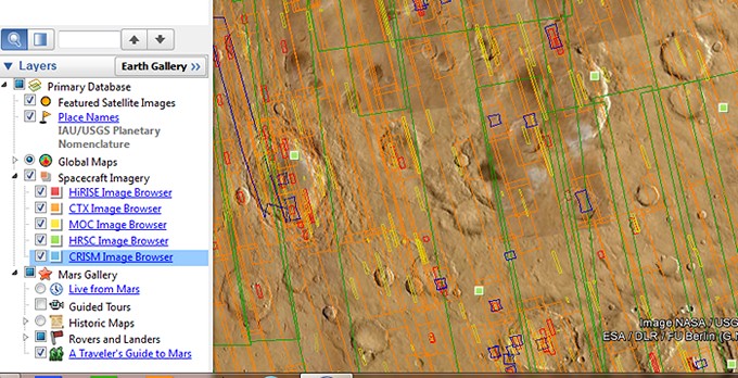
Each probe/camera has a colour and if ticked the boxes show up you can then get links to the images the best are the HiRise ones for example
One of Hoaglands supposed glass tubes on mars looks different in hi-res.
Once the pictures below loads click on it for full size.
hirise.lpl.arizona.edu...
Google , Microsft Worldwide Telescope all get there images from Nasa Esa or other space agencies.
edit on 16-4-2013 by wmd_2008 because: (no
reason given)
reply to post by wmd_2008
Yes, wmd_8000! I guess I was not clear, but I do often use the Google option spacecraft imagery, for doing anomaly searching. Actually, I consider it to be probably the best part of the Google Mars services. That is where I got the HRSC image for my reply in this OP.
One of the things I have found, one just never knows which camera is going to have the best image of a surface area, if there are multiple camera images. I believe I have read that even the highest resolution MOC camera does not always use the highest resolution, because of on-board memory storage limitations - high pixels = lots of storage.
Again thanks for the info!
I think it's just some of the ice naturally evaporating and it shows up on the picture as looking like dark smoke. The camera apparently had some kind
of a infrared filter on it when the picture was taken. That's my 2 cents.
edit on 16-4-2013 by sean because: (no reason given)
reply to post by sean
In that case wouldn't the smoke be escaping the crater in different directions, creating black marks all over the crater? The black smoke only appear on one end of the crater. I'm no expert, just my thoughts.
In that case wouldn't the smoke be escaping the crater in different directions, creating black marks all over the crater? The black smoke only appear on one end of the crater. I'm no expert, just my thoughts.
Originally posted by Cynicaleye
reply to post by sean
In that case wouldn't the smoke be escaping the crater in different directions, creating black marks all over the crater? The black smoke only appear on one end of the crater. I'm no expert, just my thoughts.
Well I am no expert either, but that ice from what I recall reading things from NASA is mostly made up of methane. Methane freezes at around -300 melts back into liquid at around -100 and boils at 67 F. So it's some pretty funky stuff. I imagine if the temps go from a dramatic change say -300 to 32 F you're going to see some kind of vapor coming off it. Temps on mars has reached 80 F on hot summer days. During the winter it's a cold bugger. If you've ever seen or messed with dry ice (frozen carbon dioxide) it gives off a gas vapor as it thaws in warmer temps, same kind of concept.
Originally posted by wmd_2008
Originally posted by newcovenant
reply to post by Cynicaleye
They look like tunnel openings revealing a reflective inner planet. The marking that look like trails behind are scatter left from digging out the holes. Of course, I'm sure they are something else.edit on 16-4-2013 by newcovenant because: (no reason given)
You are joking I hope because look at the images above your post!!!
Yeah, those are the images I'm talking about. Does look like the planet is filled with the molten blue plasma and these are holes entering into it. It doesn't to you? I am not saying what it is, I am saying what it looks like to me and NO, I am not kidding. It looks like that to me. Hook me up to a lie detector and you will find that YES, it looks like that to me. I don't see where what I think presents a problem much worse than I may be wrong and it will not be the first time for that sooooo.......
Originally posted by newcovenant
Yeah, those are the images I'm talking about. Does look like the planet is filled with the molten blue plasma and these are holes entering into it. It doesn't to you? I am not saying what it is, I am saying what it looks like to me and NO, I am not kidding. It looks like that to me. Hook me up to a lie detector and you will find that YES, it looks like that to me. I don't see where what I think presents a problem much worse than I may be wrong and it will not be the first time for that sooooo.......
Even this image or did you not see the link
viewer.mars.asu.edu...
Click on the image at link above to see in greater detail.
reply to post by wmd_2008
Hi wmd! We have talked above about the resolution differences in the MOC image and the HRSC image. You seem to know quite a bit about this image stuff, and that is helpful to many of us. In looking at both of these, I see a couple of other things that "might" contribute to the significant real differences in these photos.
Of course, you did mentioned the resolution quality of the MOC image was higher. But, if I read the dates correctly, the HRSC image of the planet surface was made in yr 2007, so it is a more recent view, since the MOC image was done in 2001. That might be a basis for some of the photo differences...?
While you would certainly know more about this than I do, I believe that the HRSC imaging is done in "3D". My thought is, a photo of the planet surface taken with 3D imaging also should result in considerably more visible detail for us to see as we peruse this images - which also could further explain some of the differences in these two photos (assuming MOC is only "2D"??).
wmd_2000, I will look forward to your comments on these differences!
For ease of reference, I will provide the link again for the HRSC image:
viewer.mars.asu.edu...
edit on 18-4-2013 by rdunk because: add link
Originally posted by rdunk
reply to post by wmd_2008
Of course, you did mentioned the resolution quality of the MOC image was higher. But, if I read the dates correctly, the HRSC image of the planet surface was made in yr 2007, so it is a more recent view, since the MOC image was done in 2001. That might be a basis for some of the photo differences...?
While you would certainly know more about this than I do, I believe that the HRSC imaging is done in "3D". My thought is, a photo of the planet surface taken with 3D imaging also should result in considerably more visible detail for us to see as we peruse this images - which also could further explain some of the differences in these two photos (assuming MOC is only "2D"??).
wmd_2000, I will look forward to your comments on these differences!
For ease of reference, I will provide the link again for the HRSC image:
viewer.mars.asu.edu...
edit on 18-4-2013 by rdunk because: add link
Sorry for the late reply.
First the image you linked to from the site info Maximum Resolution 11.6 m/pixel , it says best resolution it gets is 10m/pixel
From the MOC image I linked to Instrument MOC-NA a narrow angle camera that obtained grayscale (black-and-white) high resolution images (typically 1.5 to 12 m per pixel) Scaled Pixel Width 5.78 m
Image resolution is more important, 3d lets you see spacing/relationship between objects which is obviously nice but for example imagine an object 15m x 15m at the best resolution of both cameras so for HRSC that would be 1.5x1.5 pixels on the MOC that would be 10x10 pixels so 2.25 pixels sq v 100 pixels sq.
That's in simple terms.
As for the differences in the images what about the sun position,dust/dirt if the trail was left by that object landing/coming to rest as some claim it would be on both images.
new topics
-
Where should Trump hold his next rally
2024 Elections: 43 minutes ago -
Shocking Number of Voters are Open to Committing Election Fraud
US Political Madness: 1 hours ago -
Gov Kristi Noem Shot and Killed "Less Than Worthless Dog" and a 'Smelly Goat
2024 Elections: 2 hours ago -
Falkville Robot-Man
Aliens and UFOs: 2 hours ago -
James O’Keefe: I have evidence that exposes the CIA, and it’s on camera.
Whistle Blowers and Leaked Documents: 3 hours ago -
Australian PM says the quiet part out loud - "free speech is a threat to democratic dicourse"...?!
New World Order: 3 hours ago -
Ireland VS Globalists
Social Issues and Civil Unrest: 4 hours ago -
Biden "Happy To Debate Trump"
2024 Elections: 4 hours ago -
RAAF airbase in Roswell, New Mexico is on fire
Aliens and UFOs: 5 hours ago -
What is the white pill?
Philosophy and Metaphysics: 6 hours ago
top topics
-
A Warning to America: 25 Ways the US is Being Destroyed
New World Order: 14 hours ago, 21 flags -
Blast from the past: ATS Review Podcast, 2006: With All Three Amigos
Member PODcasts: 7 hours ago, 11 flags -
Mike Pinder The Moody Blues R.I.P.
Music: 7 hours ago, 8 flags -
Biden "Happy To Debate Trump"
2024 Elections: 4 hours ago, 8 flags -
Australian PM says the quiet part out loud - "free speech is a threat to democratic dicourse"...?!
New World Order: 3 hours ago, 7 flags -
James O’Keefe: I have evidence that exposes the CIA, and it’s on camera.
Whistle Blowers and Leaked Documents: 3 hours ago, 6 flags -
What is the white pill?
Philosophy and Metaphysics: 6 hours ago, 5 flags -
Ireland VS Globalists
Social Issues and Civil Unrest: 4 hours ago, 4 flags -
RAAF airbase in Roswell, New Mexico is on fire
Aliens and UFOs: 5 hours ago, 4 flags -
Putin, Russia and the Great Architects of the Universe
ATS Skunk Works: 10 hours ago, 3 flags
active topics
-
Where should Trump hold his next rally
2024 Elections • 5 • : DontTreadOnMe -
University of Texas Instantly Shuts Down Anti Israel Protests
Education and Media • 306 • : Xtrozero -
Biden "Happy To Debate Trump"
2024 Elections • 38 • : JadedGhost -
Russia Ukraine Update Thread - part 3
World War Three • 5737 • : Arbitrageur -
Gov Kristi Noem Shot and Killed "Less Than Worthless Dog" and a 'Smelly Goat
2024 Elections • 26 • : CarlLaFong -
James O’Keefe: I have evidence that exposes the CIA, and it’s on camera.
Whistle Blowers and Leaked Documents • 8 • : Athetos -
Weinstein's conviction overturned
Mainstream News • 29 • : Xtrozero -
Shocking Number of Voters are Open to Committing Election Fraud
US Political Madness • 2 • : xuenchen -
Candidate TRUMP Now Has Crazy Judge JUAN MERCHAN After Him - The Stormy Daniels Hush-Money Case.
Political Conspiracies • 810 • : Annee -
Do you ever just get "bored" of everything?
Rant • 22 • : JonnyC555