It looks like you're using an Ad Blocker.
Please white-list or disable AboveTopSecret.com in your ad-blocking tool.
Thank you.
Some features of ATS will be disabled while you continue to use an ad-blocker.

The Perfect Storm
page: 2share:
Originally posted by Nyiah
I predict this will be a whole bunch of nothing. Approaching weather systems & cooler water considered, it's probably going to stay well offshore, and weak.
I'm still hoping for a sharp left turn to FL when it gets over the Bahamas, as much of a flat 0% chance as it is. We still need the rain, and unlike the wussy New Englanders, we ain't afraid of no wind down here
With a strong rex block in place, it isn't going out into the atlantic at this point, almost 0% chance.
Likely it hits somewhere between cape may and the bay of maine, with most models having it hit around Long Island. Really ends up depending how the jet streams are positioned from the high coming in from the pacific.
Public advisory 11 just came out...not too much new...she is expected to hit Cat 2, and then drop back down. And just saying...she really is a big
wide son of a gun. Doesnt really matter that she will drop back down to TS strength in a few days, her size is going to cause some bad waves and a
hell of a lot of rain.
Pub Adv 11
www.nhc.noaa.gov...
Peace
Edit.. Just wanted to add that CNN is reporting the first fatality from Sandy in Jamiaca and that the island is at 70% without power
news.blogs.cnn.com...
Pub Adv 11
www.nhc.noaa.gov...
Peace
Edit.. Just wanted to add that CNN is reporting the first fatality from Sandy in Jamiaca and that the island is at 70% without power
news.blogs.cnn.com...
edit on 24-10-2012 by lasertaglover because: (no
reason given)
Looks like bad weather heading your way.
Stay safe and thanks for posting this weather alert.
Stay safe and thanks for posting this weather alert.
Federal forecasters warn that much of the eastern U.S. has a good chance for several sloppy days of weather mayhem early next week. They predict heavy rain or snow, persistent gale-force winds, storm surge and flooding from an unusual hybrid of hurricane and winter storm. Meteorologists predict that Hurricane Sandy in the Caribbean will collide with an early winter storm from the West and a blast of arctic air from the North, sloshing and parking over the country's most populous coastal corridor starting Sunday. The worst of it should be early Tuesday, but it could stretch into Halloween on Wednesday and beyond. The National Oceanic and Atmospheric Administration warns it will hit around the full moon, increasing the potential for flooding. Read more: www.vancouversun.com...
edit on 25-10-2012 by violet because: (no reason given)
reply to post by Nyiah
If you are going to brag that you are more experienced, then you should know that is storm surge that causes the damage, not wind.
If you are going to brag that you are more experienced, then you should know that is storm surge that causes the damage, not wind.
this storm is very reminiscent of hurricane Agnes in 1972, not so much the southern storm track but the mid atlantic/ northeastern potential and
possible reformation with another front. that storm just sat here and rained for a week and we ended up having the costliest hurricane ever in the
north east. they retired the hurricane name Agnes for that storm.
i remember looking down at my uncles home, from a hill, it was under 22 feet of water and i was terrified at 7 years old.
i remember looking down at my uncles home, from a hill, it was under 22 feet of water and i was terrified at 7 years old.
Sandy is one big storm. Just a few days ago the hurricane experts were saying she would not go bigger than a Cat 1, and that she would go NE.
Well she was darn close this morning to a Cat 3 at 105 mph winds, and each day there are more tracks showing her hitting the mainland.
Latest imagery:
www.nhc.noaa.gov...

And latest forecast tracks:
www.weather.com...
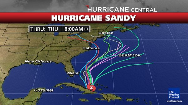
The bottom line is that she needs to be watched carefully. She is going to merge with some really strong energy in a few days. Here where I am in Michigan, it's going to be close to 80 today, tomorrow it is going to be 52! The jet stream is moving really strong energy that way, plus the full moon, plus the fact that she is HUGE equals some really scary potential.
It is not freak out time yet, it is simply time to keep a damn close eye on this.
Peace
Well she was darn close this morning to a Cat 3 at 105 mph winds, and each day there are more tracks showing her hitting the mainland.
Latest imagery:
www.nhc.noaa.gov...
And latest forecast tracks:
www.weather.com...
The bottom line is that she needs to be watched carefully. She is going to merge with some really strong energy in a few days. Here where I am in Michigan, it's going to be close to 80 today, tomorrow it is going to be 52! The jet stream is moving really strong energy that way, plus the full moon, plus the fact that she is HUGE equals some really scary potential.
It is not freak out time yet, it is simply time to keep a damn close eye on this.
Peace
I'm glad I live in the U.P. No hurricanes, not many tornadoes, no rattlers yet, no overcrowding. Drawback is snow and cold along with higher
prices.
I don't want to "rain on yor parade" but i would suggest that Sandy will not make direct landfall over New York. I am leaning more towards a skirt
up the east coast and a sharp westerly turn out to the Atlantic in a heading toward the Bay of Biscay/Iberia. The Jet Stream forecast looks like it
will take this route, and any mid atlantic blocking could quite easily be moved.
If it did make landfall, the worst affected areas would be the north east quadrant, which consequently will be out at sea.
Given the fact that the further north you travel, the less intense the storm will become, unless of course it can soak energy from any warm fronts, which are few and far between at the moment.
My prediction:
Very slight landfall, possibly some flooding along very eastern low laying coasts, max wind gusts possibly hitting 80mph on exposed coasts. High rainfall totals but mostly out at sea. A sharp westerly track around New York. Downgraded to tropical storm after passing teh Bahamas.
reply to post by jrmcleod
You could be correct in your assessment, but my understanding is that Sandy will actually become a hybrid storm when it combines with some mid latitude weather. This could result in a lessening of the harsh hurricane elements of the storm (like high winds around the eye wall) but make the overall destructiveness of the storm more widespread. In other words, it may not pack the same focused punch as its tropical beginnings, but the combined larger storm could bring very nasty weather to a larger area. Here in Maryland, we're keeping a close eye especially considering it's closing in on full moon tides.
Only time will tell though...
reply to post by LittleBlackEagle
Just noticed your mention of a storm in 1972. Jessica Marachalo psychic said that she saw the number 72 in her vision. Coincidence or what. Cyclone plus something else she couldn't describe.
Just noticed your mention of a storm in 1972. Jessica Marachalo psychic said that she saw the number 72 in her vision. Coincidence or what. Cyclone plus something else she couldn't describe.
edit on 25-10-2012 by prophetboy12 because: spelling
reply to post by storm2012
To complete this perfect storm it would take an x class flare which just happened and there is a 10 percent chance of more. Sunspot 1598 is huge and very active.
To complete this perfect storm it would take an x class flare which just happened and there is a 10 percent chance of more. Sunspot 1598 is huge and very active.
edit on 25-10-2012 by prophetboy12 because: wrong sunspot number
I hope they don't fire up HAARP. What TIMING this thing has. If we look at the occult side of things....it could be the perfect storm for them, as
well. What scares me most, is the fact that this is going to happen during Halloween. Talk about an ultimate sacrifice.
I live in Conneticut, we had two bad storms last year, Irene and the Halloween snow storm. We lost power for a week in each of these storms and it
looks like we are in the Bulls Eye again.
I am now getting ready for this one. Wish us luck.
I am now getting ready for this one. Wish us luck.
Yup. We're prepared for what's coming...
I'm hoping it's not as bad as last Halloween's storm.
I'm hoping it's not as bad as last Halloween's storm.
this thing is looking like its going to hit straight into the region of new jersey and new york city area, could be a disaster if it combines with
another low pressure system and god knows how long and how strong this system will spin around the NJ area.
Models are now showing that the Blizzacane is going to smack into New England
www.wunderground.com...
www.wunderground.com...
We have a cold front going over us right now in Minnesota that is supposed to meet up with Sandy when she hits the east coast. It is snowing like
crazy out here, lots of moisture headed east with this front.
I'll get a few pictures with my camera and post them
This is the other part of what is heading to the east coast.
I'll get a few pictures with my camera and post them
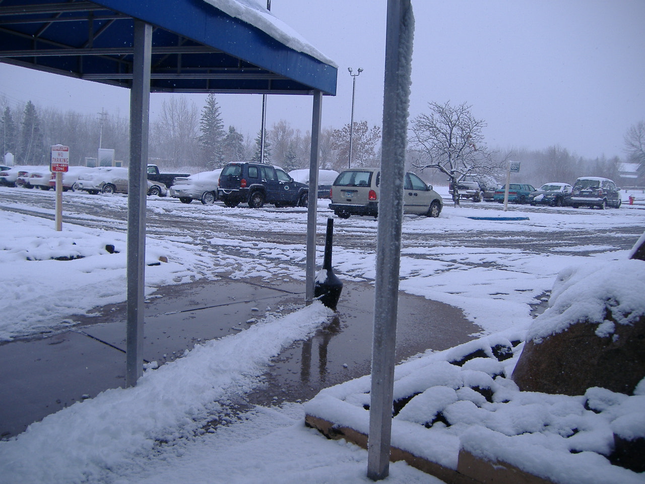

This is the other part of what is heading to the east coast.
edit on 25-10-2012 by Darkblade71 because: Added pics
Hmmm...latest track from NOAA:
www.nhc.noaa.gov...
A member over in the Hurricane thread said the local Philly people are calling it a SNOR'EASTICANE because it is looking to be a combo snow, nor easter, hurricane combo thingy.
And I did see there are members on here that think it will be nothing...Personally, I follow what NOAA says.
Peace
new topics
-
Shocking Number of Voters are Open to Committing Election Fraud
US Political Madness: 21 seconds ago -
Gov Kristi Noem Shot and Killed "Less Than Worthless Dog" and a 'Smelly Goat
2024 Elections: 46 minutes ago -
Falkville Robot-Man
Aliens and UFOs: 1 hours ago -
James O’Keefe: I have evidence that exposes the CIA, and it’s on camera.
Whistle Blowers and Leaked Documents: 1 hours ago -
Australian PM says the quiet part out loud - "free speech is a threat to democratic dicourse"...?!
New World Order: 2 hours ago -
Ireland VS Globalists
Social Issues and Civil Unrest: 2 hours ago -
Biden "Happy To Debate Trump"
Mainstream News: 3 hours ago -
RAAF airbase in Roswell, New Mexico is on fire
Aliens and UFOs: 3 hours ago -
What is the white pill?
Philosophy and Metaphysics: 5 hours ago -
Mike Pinder The Moody Blues R.I.P.
Music: 5 hours ago
top topics
-
A Warning to America: 25 Ways the US is Being Destroyed
New World Order: 13 hours ago, 21 flags -
Mike Pinder The Moody Blues R.I.P.
Music: 5 hours ago, 7 flags -
Biden "Happy To Debate Trump"
Mainstream News: 3 hours ago, 7 flags -
James O’Keefe: I have evidence that exposes the CIA, and it’s on camera.
Whistle Blowers and Leaked Documents: 1 hours ago, 5 flags -
What is the white pill?
Philosophy and Metaphysics: 5 hours ago, 5 flags -
Australian PM says the quiet part out loud - "free speech is a threat to democratic dicourse"...?!
New World Order: 2 hours ago, 5 flags -
Ireland VS Globalists
Social Issues and Civil Unrest: 2 hours ago, 4 flags -
RAAF airbase in Roswell, New Mexico is on fire
Aliens and UFOs: 3 hours ago, 4 flags -
Putin, Russia and the Great Architects of the Universe
ATS Skunk Works: 8 hours ago, 3 flags -
Falkville Robot-Man
Aliens and UFOs: 1 hours ago, 1 flags
active topics
-
Shocking Number of Voters are Open to Committing Election Fraud
US Political Madness • 0 • : FlyersFan -
Candidate TRUMP Now Has Crazy Judge JUAN MERCHAN After Him - The Stormy Daniels Hush-Money Case.
Political Conspiracies • 803 • : xuenchen -
Gov Kristi Noem Shot and Killed "Less Than Worthless Dog" and a 'Smelly Goat
2024 Elections • 18 • : StoutBroux -
Re-election Tactic - JOE BIDEN Hints He May Put Books in the Homes of Black People.
2024 Elections • 30 • : WeMustCare -
Australian PM says the quiet part out loud - "free speech is a threat to democratic dicourse"...?!
New World Order • 3 • : Athetos -
Biden "Happy To Debate Trump"
Mainstream News • 35 • : WeMustCare -
University of Texas Instantly Shuts Down Anti Israel Protests
Education and Media • 297 • : cherokeetroy -
-@TH3WH17ERABB17- -Q- ---TIME TO SHOW THE WORLD--- -Part- --44--
Dissecting Disinformation • 699 • : Thoughtful3 -
Putin, Russia and the Great Architects of the Universe
ATS Skunk Works • 25 • : SchrodingersRat -
Ditching physical money
History • 22 • : StudioNada