It looks like you're using an Ad Blocker.
Please white-list or disable AboveTopSecret.com in your ad-blocking tool.
Thank you.
Some features of ATS will be disabled while you continue to use an ad-blocker.

Full Titanic wreck site is mapped for 1st time
page: 116
share:
Researchers from half a dozen organizations have teamed up to create the most comprehensive map of the Titanic wreck site yet.
The map covers an area of 3x5 miles or 5x8 km. Most of the sonar mapping was done by autonomous underwater vehicles (AUVs) which were underwater robots not controlled by humans.
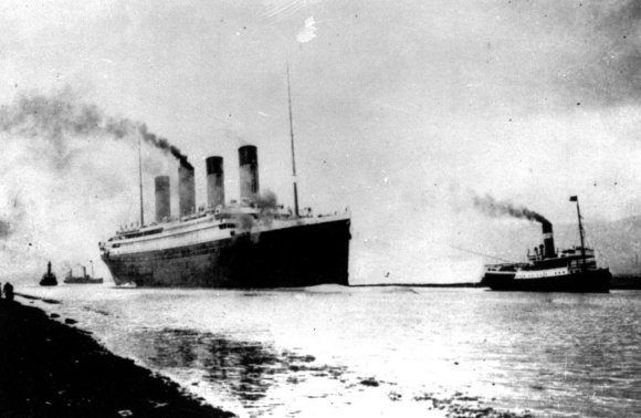
The first image shows the Titanic departing Southampton, England on her maiden voyage to New York. No one could have imagined her fate and the huge loss of life. Of the 2,200 people aboard, almost 70% or 1,517 would ultimately perish.
The image below shows the wreck site. North is towards the top. The Titanic broke into two pieces as she plumeted to the ocean floor. The bow section is large piece near the top of the image, and the stern section is further south near the bottom of the image. They are separated by approximately 2,000 feet.
High Resolution image: Wreck Site
In this image one can see the following:
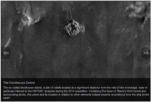
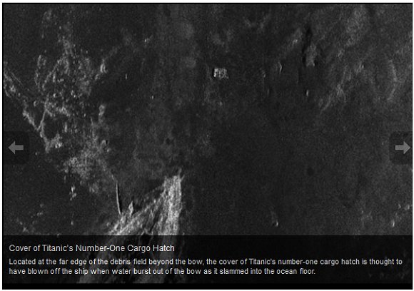
On the Eastern edge of the map, halfway down is deckhouse debris from the middle of the ship:
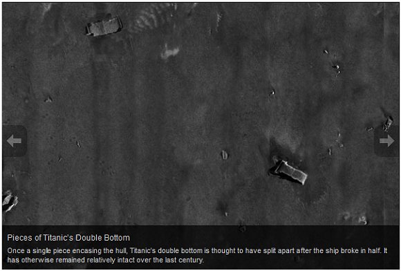
South of this deckhouse debris are pieces of the double hull which separated from the ship as she broke in half:
Notice how far east of the main bow and stern sections these pieces are.
The bow section is shown below:
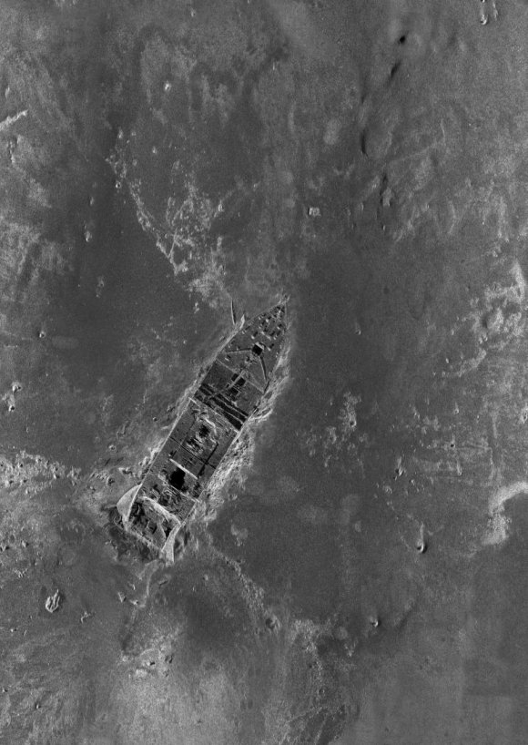
High resolution: Bow Section
The seafloor mud and sediment was obviously disturbed as the bow sliced into the bottom.
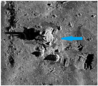
Just NNE of the bow is a square shaped object:
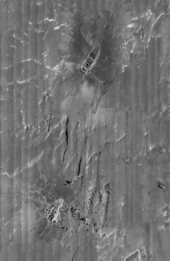
The stern section of the Titanic shows the most damage and looks like it was crushed and ripped apart:
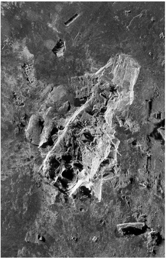
This image shows the incredible forces inflicted on the Titanic as she sank and hit bottom.
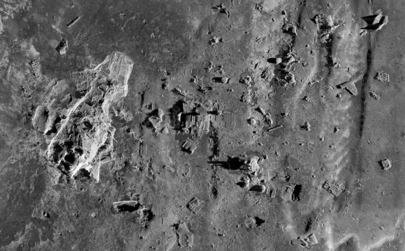
East of the stern section is a large debris field:
Full resolution: Stern Section
This pattern of debris just to the East of the stern section suggests to researchers that the stern section rotated like a "helicopter blade" as it sank.
Researchers will be studying these images for clues on why the Titanic floundered like it did. The History Channel will also be airing a documentary based on these new sonar maps.
Sources:
www.google.com...
www.history.com...
The map covers an area of 3x5 miles or 5x8 km. Most of the sonar mapping was done by autonomous underwater vehicles (AUVs) which were underwater robots not controlled by humans.
The first image shows the Titanic departing Southampton, England on her maiden voyage to New York. No one could have imagined her fate and the huge loss of life. Of the 2,200 people aboard, almost 70% or 1,517 would ultimately perish.
The image below shows the wreck site. North is towards the top. The Titanic broke into two pieces as she plumeted to the ocean floor. The bow section is large piece near the top of the image, and the stern section is further south near the bottom of the image. They are separated by approximately 2,000 feet.
High Resolution image: Wreck Site
In this image one can see the following:
On the Eastern edge of the map, halfway down is deckhouse debris from the middle of the ship:
South of this deckhouse debris are pieces of the double hull which separated from the ship as she broke in half:
Notice how far east of the main bow and stern sections these pieces are.
The bow section is shown below:
High resolution: Bow Section
The seafloor mud and sediment was obviously disturbed as the bow sliced into the bottom.
Just NNE of the bow is a square shaped object:
The stern section of the Titanic shows the most damage and looks like it was crushed and ripped apart:
This image shows the incredible forces inflicted on the Titanic as she sank and hit bottom.
East of the stern section is a large debris field:
Full resolution: Stern Section
This pattern of debris just to the East of the stern section suggests to researchers that the stern section rotated like a "helicopter blade" as it sank.
Researchers will be studying these images for clues on why the Titanic floundered like it did. The History Channel will also be airing a documentary based on these new sonar maps.
Sources:
www.google.com...
www.history.com...
reply to post by guppy
You're welcome. My jaw literally dropped when I saw these images. Their use of autonomous robots is pretty cool too.
I'm trying to identify various bits and pieces, while also taking in the whole scene. If someone sees anything interesting, let us know!
You're welcome. My jaw literally dropped when I saw these images. Their use of autonomous robots is pretty cool too.
I'm trying to identify various bits and pieces, while also taking in the whole scene. If someone sees anything interesting, let us know!
Could this be one of Titanic's boilers, east of the stern section?
It's hard to remain detached, knowing what happened there.
It's hard to remain detached, knowing what happened there.
what a fantastic find. Nice work...
It's amazing to be able to see it like that, and in such high-res, too... what amazing images.
thanks!
It's amazing to be able to see it like that, and in such high-res, too... what amazing images.
thanks!
so does that mean that the conspiracy theory that a submarine torpedoed the Titanic isnt doesnt hold any water due to this information posted here?
Originally posted by krazyiven
so does that mean that the conspiracy theory that a submarine torpedoed the Titanic isnt doesnt hold any water due to this information posted here?
The best German submarine in operation at the time was the Type U 2. It barely had the range to make it from Germany to the North American Coast and back. More significantly, it only had a maximum speed of 13.2 knots, while the Titanic was speeding at over 20 knots. So the Uboat would have had to be ahead of the Titanic at just the right place and time waiting for her to arrive.
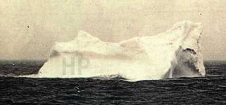
There are however many reports of icebergs in the area Titanic sank, not to mention everyone on deck saw the iceberg and reported the iceberg strike. Some people think this is the actual iceberg that Titanic hit, it was in the right location and shows damage:
www.encyclopedia-titanica.org...
Titanic's sister ship, Britannic, was either torpedoed or hit a mine (which is basically an anchored torpedo) in 1916 off Greece during WWI. Her wreck has been explored by by Jacques Cousteau and Robert Ballard among others. Her wreck looks like this, totally different than the Titanic wreck:
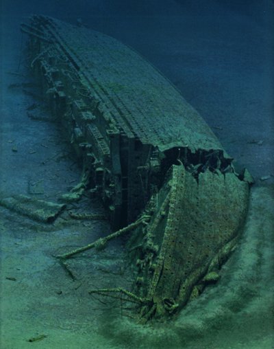
Although the bow is damaged where she hit bottom, the ship is still basically intact. The torpedo or mine hole is not visible since she is lying on her side.
marconigraph.com...
Also, while it took Titanic 2 hours and 40 minutes to sink, Britannic sunk in only 55 minutes, even with improvements made after the Titanic sinking.
So my short answer is no, Titanic hit an iceberg, and was not attacked by a Uboat.
It's ironic that of the three "unsinkable" Olympic-class ships (Titanic, Britannic and Olympic), two floundered in a relatively short period of time.
reply to post by Nicolas Flamel
well thank you! I actually had never heard the theory of Titanic getting hit by a Uboat until i came here to ATS. Thanks for the info!
well thank you! I actually had never heard the theory of Titanic getting hit by a Uboat until i came here to ATS. Thanks for the info!
new topics
-
Putin, Russia and the Great Architects of the Universe
ATS Skunk Works: 3 hours ago -
A Warning to America: 25 Ways the US is Being Destroyed
New World Order: 7 hours ago
top topics
-
President BIDEN's FBI Raided Donald Trump's Florida Home for OBAMA-NORTH KOREA Documents.
Political Conspiracies: 13 hours ago, 31 flags -
A Warning to America: 25 Ways the US is Being Destroyed
New World Order: 7 hours ago, 13 flags -
Is AI Better Than the Hollywood Elite?
Movies: 14 hours ago, 4 flags -
Maestro Benedetto
Literature: 14 hours ago, 1 flags -
Putin, Russia and the Great Architects of the Universe
ATS Skunk Works: 3 hours ago, 1 flags
active topics
-
Gaza Terrorists Attack US Humanitarian Pier During Construction
Middle East Issues • 50 • : FlyersFan -
Chris Christie Wishes Death Upon Trump and Ramaswamy
Politicians & People • 26 • : FlyersFan -
Sol Et Luna - TIME2024
Short Stories • 11 • : Encia22 -
Any one suspicious of fever promotions events, major investor Goldman Sachs card only.
The Gray Area • 11 • : mysterioustranger -
Ode to Artemis
General Chit Chat • 1 • : Encia22 -
A Warning to America: 25 Ways the US is Being Destroyed
New World Order • 15 • : jidnum2 -
Skinwalker Ranch and the Mystery 1.6GHz Signal
Aliens and UFOs • 145 • : Ophiuchus1 -
University of Texas Instantly Shuts Down Anti Israel Protests
Education and Media • 273 • : HerbertWest -
Krystalnacht on today's most elite Universities?
Social Issues and Civil Unrest • 6 • : FlyersFan -
Hate makes for strange bedfellows
US Political Madness • 50 • : 19Bones79
16