It looks like you're using an Ad Blocker.
Please white-list or disable AboveTopSecret.com in your ad-blocking tool.
Thank you.
Some features of ATS will be disabled while you continue to use an ad-blocker.

Quake Watch 2012
page: 66share:
Magnitude 2.1 British Columbia. Canada
Location in Google Maps
- Date-Time: Tuesday, March 06, 2012 at 22:05:17 UTC,
Tuesday, March 06, 2012 at 02:05:17 PM at epicenter
- Location: 49.404°N, 120.471°W
- Depth: 0 km (~0 mile) (poorly constrained)
- Region: BRITISH COLUMBIA, CANADA
- Distances: (a probable quarry explosion)
65 km (40 miles) W 261° from Penticton, British Columbia, Canada,
82 km (51 miles) SSW 212° from Central Okanagan, British Columbia, Canada,
91 km (56 miles) SW 234° from Kelowna, British Columbia, Canada
138 km (86 miles) ENE 73° from Abbotsford, British Columbia, Canada
193 km (120 miles) E 85° from Vancouver, British Columbia, Canada
- Location Uncertainty: horizontal +/- 2.7 km (1.7 miles); depth +/- 31.6 km (19.6 miles)
- Parameters: Nph= 6, Dmin=63 km, Rmss=0.36 sec, Gp=281°,
M-type=duration magnitude (Md), Version=1
- Source: Pacific Northwest Seismic Network
- Event ID: uw60401586
Data Source: USGS
Powered by QVSData
They just sneaked this in under the radar. Only small but the other end of the wobble. Only just came in now. Just wonder why they posted it if it is a quarry explosion.
If this looks different it is because I am experimenting with an automated paste to clipboard from my program.
edit on 7/3/2012 by PuterMan because: (no reason given)
reply to post by PuterMan
Was that one even felt?
EMSC
Was that one even felt?
Magnitude ML 3.4
Region ROMANIA
Date time 2012-03-07 15:34:24.0 UTC
Location 44.46 N ; 26.03 E
Depth 11 km
Distances 8 km SE Chitila (pop 12,788 ; local time 17:34:24.2 2012-03-07)
6 km W Bucharest (pop 1,877,155 ; local time 17:34:24.2 2012-03-07)
5 km E Chiajna (pop 8,105 ; local time 17:34:24.2 2012-03-07)
EMSC
reply to post by Hellas
No it was just an excuse to try out the formatting from my clipboard copy - which needs some work by the look of it. Also as I said, why are they posting an explosion. They don't usually.
No it was just an excuse to try out the formatting from my clipboard copy - which needs some work by the look of it. Also as I said, why are they posting an explosion. They don't usually.
Originally posted by PuterMan
reply to post by Hellas
No it was just an excuse to try out the formatting from my clipboard copy - which needs some work by the look of it. Also as I said, why are they posting an explosion. They don't usually.
looks great though
Magnitude mb 4.5
Region IRAN-IRAQ BORDER REGION
Date time 2012-03-07 16:57:13.0 UTC
Location 32.56 N ; 47.07 E
Depth 10 km
Distances 80 km NW Al-'amarah (pop 323,302 ; local time 19:57:13.7 2012-03-07)
240 km NW Al-basrah (pop 2,015,483 ; local time 19:57:13.7 2012-03-07)
23 km SW Dehloran (pop 46,002 ; local time 19:57:13.7 2012-03-07)
EMSC
Another bit of techy for you PM, this post was inspired by your response in
berkeleygal's thread about the Haywood Fault.
Ionospheric total electron content variations observed before earthquakes: Possible physical mechanism and modeling
From the Abstract:
They are using data from GPS satellites, but not in a locational function. Rather, they using them as electron detectors and measuring the magnetosphere and ionosphere to determine if there are any anomalous fluctuations in either field that could be attributable as seismic precursor activity.
It seems as though there is, in some cases, a measurable difference in both the ionosphere and magnetosphere preceding earthquakes of unusual size (EOUS's?).
In other words, the closer to the magnetic equator the epicenter of the quake is, the steeper the magnetic trough will be. There is a corresponding disturbance in the opposite hemisphere of the magnetic field as the quake.
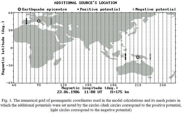
The following image is a cross section of the magnetic field, think of the x axis as being the surface of the earth and the y axis is an imaginary line extending perpendicularly out from the surface from the magnetic equator. The "hills" represent areas of anomalous enhancements to the local magnetic field and would create a bulge in the ionosphere.
A sort of magnetic volcano, if you will....
Ionospheric total electron content variations observed before earthquakes: Possible physical mechanism and modeling
From the Abstract:
The GPS derived anomalous TEC disturbances before earthquakes were discovered in the last years using global and regional TEC maps, ... For strong mid-latitudinal earthquakes the seismo-ionospheric anomalies look like local TEC enhancements ... We consider that the most probable reason of the NmF2 and TEC disturbances observed before the earthquakes is the vertical drift of the F2-region ionospheric plasma under the influence of the zonal electric field of seismic origin. ... The results of the corresponding numerical model calculations have revealed a fine agreement with TEC anomalies observed before strong earthquakes at the middle and low latitudes both in spatial scales and in amplitude characteristics.
They are using data from GPS satellites, but not in a locational function. Rather, they using them as electron detectors and measuring the magnetosphere and ionosphere to determine if there are any anomalous fluctuations in either field that could be attributable as seismic precursor activity.
It seems as though there is, in some cases, a measurable difference in both the ionosphere and magnetosphere preceding earthquakes of unusual size (EOUS's?).
The extensive studies of the ionospheric earthquake precursors in the GPS TEC measurements carried
out in the last years have revealed that for strong mid-latitudinal earthquakes the seismo-ionospheric anomalies
very often (usually) look as local TEC increases and they are situated in the immediate vicinity of the earthquake
epicenter area.
In case of TEC enhancements in the middle latitudes and deepening of the equatorial anomaly trough this field is directed to the east and induces the electromagnetic drift of the plasma across the geomagnetic field with velocity directed straight upwards over the magnetic equator and upwards and pole wards in the middle latitudes.
In other words, the closer to the magnetic equator the epicenter of the quake is, the steeper the magnetic trough will be. There is a corresponding disturbance in the opposite hemisphere of the magnetic field as the quake.
The following image is a cross section of the magnetic field, think of the x axis as being the surface of the earth and the y axis is an imaginary line extending perpendicularly out from the surface from the magnetic equator. The "hills" represent areas of anomalous enhancements to the local magnetic field and would create a bulge in the ionosphere.
A sort of magnetic volcano, if you will....
reply to post by Hellas
Or a slight reduction if you shop with USGS
Location in Google Maps
Derived from Data Source: USGS
Powered by QVSData
Or a slight reduction if you shop with USGS
Magnitude 4.4 Iran-Iraq border region
Location in Google Maps
- Date-Time: Wednesday, March 07, 2012 at 16:57:11 UTC
Wednesday, March 07, 2012 at 07:57:11 PM at epicenter
- Location: 32.520°N, 47.085°E
- Depth: 6.9 km (4.3 miles) (poorly constrained)
- Region: IRAN-IRAQ BORDER REGION
- Distances:
77 km [48 miles] N [355°] from Al-Amarah, Iraq
116 km [72 miles] E [89°] from Al-Kut, Iraq
131 km [81 miles] W [277°] from Dezful, Iran
264 km [164 miles] ESE [109°] from BAGHDAD, Iraq
- Location Uncertainty: horizontal +/- 9.6 km (6.0 miles); depth +/- 35.5 km (22.1 miles)
- Parameters: NST= 35, Nph= 35, Dmin=873.3 km, Rmss=0.93 sec, Gp= 76°,M-type=body wave magnitude (Mb), Version=6
- Source: U.S. Geological Survey, National Earthquake Information Center:
- Event ID: us2012xwbd
Derived from Data Source: USGS
Powered by QVSData
correction to post by muzzy
well this is what happens when you look, copy, paste and run.
I didn't really read the page properly.
The list on the Geonet Rapid page for each event shows the History of how the Quake was analyzed from when it was first recorded, not other quakes in the same spot.
Just looking at that Cook Strait 4.0 on Monday
beta.geonet.org.nz...
It show 17 entries and how over a period of 3 hrs 47 minutes and 42 seconds it went from an initial 2.8 to a 3.9 magnitude
and they hit mag 3.9 after 1 minute 12 seconds , reduced it to 3.8 twice then back to 3.9
Interesting, it must be them recording how long it takes to get the info up.
Still not the accuracy I would expect from the budget they are getting.
Digging deeper into their catalog data 3 days after, it was in fact Magnitude 4.025ML at 39.87km deep (not 45km)
I didn't actually download the data list on the day so don't know how much it has changed by decimal points since then, perhaps Puterman has the original magnitude on his data bank?
so it was 4.0 on the Recent Quakes list
3.9 on the Geonet Rapid
and finally 4.025 on the NZ Database Catalog
perhaps to be altered again over the next month or so as is quite usual
not saying that there is a conspiracy to hide the true facts, just that to find the real info you have to go look for it yourself.
ETA: and it moved 12.71km to the SE, closer to Wellington than Marlborough!
This where the Recent Quakes page falls down, they don't go back and correct it.
I only use that page to get the Felt Reports now.
well this is what happens when you look, copy, paste and run.
I didn't really read the page properly.
The list on the Geonet Rapid page for each event shows the History of how the Quake was analyzed from when it was first recorded, not other quakes in the same spot.
Just looking at that Cook Strait 4.0 on Monday
beta.geonet.org.nz...
It show 17 entries and how over a period of 3 hrs 47 minutes and 42 seconds it went from an initial 2.8 to a 3.9 magnitude
and they hit mag 3.9 after 1 minute 12 seconds , reduced it to 3.8 twice then back to 3.9
Interesting, it must be them recording how long it takes to get the info up.
Still not the accuracy I would expect from the budget they are getting.
Digging deeper into their catalog data 3 days after, it was in fact Magnitude 4.025ML at 39.87km deep (not 45km)
I didn't actually download the data list on the day so don't know how much it has changed by decimal points since then, perhaps Puterman has the original magnitude on his data bank?
so it was 4.0 on the Recent Quakes list
3.9 on the Geonet Rapid
and finally 4.025 on the NZ Database Catalog
perhaps to be altered again over the next month or so as is quite usual
not saying that there is a conspiracy to hide the true facts, just that to find the real info you have to go look for it yourself.
edit on
7-3-2012 by muzzy because: (no reason given)
ETA: and it moved 12.71km to the SE, closer to Wellington than Marlborough!
This where the Recent Quakes page falls down, they don't go back and correct it.
I only use that page to get the Felt Reports now.
edit on 7-3-2012 by muzzy because: (no reason given)
reply to post by jadedANDcynical
First I find this interesting. Go to the why? and see if you can work out what it should be.
As I read through the document I find this:
Researching the Alouette 2 I find
So the graph they produced was from events 1 day before the earthquake in Chile in 1963 taken by a satellite that was launched in 1965. I am not getting good vibes so far.
The above from NASA
I am not qualified to say where these on-board experiments sound like the data these people are quoting, but I have my doubts:
As I say maybe I am not in position to comment but:
Source: Wikipedia
So not I that am doubting even further, but onwards and upwards - per ardua ad astra.
The problem as I see it is that the electron content of this layer changes daily according to the time of day and the number of sunspots. My question therefore is which is the chicken and which the egg?
The next statement seems to be floating and appears an assumption deigned to baffle the reader with science.
I can't see the connection to what they are trying to say. Maybe I am just being thick.
From this pdf (Sorry has to be an image as I can't scrape it)
Not quite sure how that relates but something does not seem to be quite right. Are they re-quoting what was said in order to fool the less 'scientific' reader? I don't know. You make up your own minds.
Something wrong with that statement? Yes indeed I made it up.
I find little of positive material in that paper, by which I mean defined instances of this effect. They are all vague and referring to other papers and when you chase the down you end up in a circular morass of papers all referencing and quoting each other. Several times the authors quote papers by one of the authors which also themselves quote the authors. IF earthquakes affect the ionosphere causing a fluctuation in the TEC then it should be demonstrable in ALL cases and NOT just cherry picked examples. I would want to see evidence of quakes above say mag 6.5 with a 70% or better confirmed correlation between the timings.
We know there was a CME before Japan. Could that have affected this reading? I believe so.
Now I am well aware that scientific papers these days are often pitiful shells of what they used to be, but frankly these and the whole circular bunch are insubstantial and designed to bamboozle in my opinion.
......continued as I ran out of space............
First I find this interesting. Go to the why? and see if you can work out what it should be.
As I read through the document I find this:
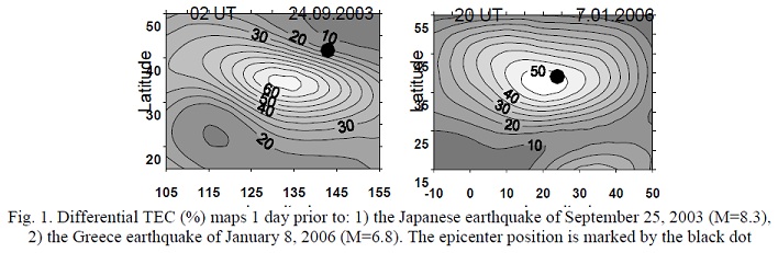
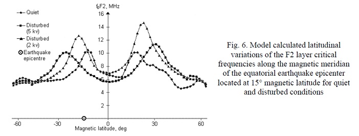
Fig. 2 presents the seismogenic equatorial anomaly observed in the measurements of Alouette-2 satellite 1 day prior to the Chile earthquake of 12 April 1963
Researching the Alouette 2 I find
Alouette 2 was a Canadian research satellite launched at 04:48 UTC on November 29, 1965 by a Thor Agena rocket with Explorer 31 from the Western test range at Vandenberg AFB in California.
So the graph they produced was from events 1 day before the earthquake in Chile in 1963 taken by a satellite that was launched in 1965. I am not getting good vibes so far.
Alouette 2 was a small ionospheric observatory instrumented with a sweep-frequency ionospheric sounder, a VLF receiver, an energetic particle experiment, a cosmic noise experiment, and an electrostatic probe.
The above from NASA
I am not qualified to say where these on-board experiments sound like the data these people are quoting, but I have my doubts:
GPS technique provides measurements of the group and phase delays of the signals L 1 =1575 MHz
and L 2 =1228 MHz with a 30-sec interval. The ionospheric delay can be transformed into the content of electrons along the signal path between a GPS satellite and GPS receiver, and then recalculated into its vertical projection. The vertical total electron content (TEC) is very sensitive to changes of the maximal electron concentration (NmF2) in the F2 layer of the ionosphere.
As I say maybe I am not in position to comment but:
The GPS project was developed in 1973 to overcome the limitations of previous navigation systems
Source: Wikipedia
So not I that am doubting even further, but onwards and upwards - per ardua ad astra.
The vertical total electron content (TEC) is very sensitive to changes of the maximal electron concentration (NmF2) in the F2 layer of the ionosphere.
The problem as I see it is that the electron content of this layer changes daily according to the time of day and the number of sunspots. My question therefore is which is the chicken and which the egg?
The next statement seems to be floating and appears an assumption deigned to baffle the reader with science.
These effects were probably related with the equatorward displacement of the equatorial anomaly northern crest and reduction of the electron concentration in the crest.
I can't see the connection to what they are trying to say. Maybe I am just being thick.
From this pdf (Sorry has to be an image as I can't scrape it)
Not quite sure how that relates but something does not seem to be quite right. Are they re-quoting what was said in order to fool the less 'scientific' reader? I don't know. You make up your own minds.
Of course it is an established fact that the spin rate of molecular ions O2+ and NO+, and atomic ions O+ in the F1 region can also affect the TEC and may provide a mechanism for the observed anomalies.
Something wrong with that statement? Yes indeed I made it up.
I find little of positive material in that paper, by which I mean defined instances of this effect. They are all vague and referring to other papers and when you chase the down you end up in a circular morass of papers all referencing and quoting each other. Several times the authors quote papers by one of the authors which also themselves quote the authors. IF earthquakes affect the ionosphere causing a fluctuation in the TEC then it should be demonstrable in ALL cases and NOT just cherry picked examples. I would want to see evidence of quakes above say mag 6.5 with a 70% or better confirmed correlation between the timings.
We know there was a CME before Japan. Could that have affected this reading? I believe so.
Now I am well aware that scientific papers these days are often pitiful shells of what they used to be, but frankly these and the whole circular bunch are insubstantial and designed to bamboozle in my opinion.
......continued as I ran out of space............
edit on 7/3/2012 by PuterMan because: (no reason given)
....continuation
Don't get me wrong, I am not denying the connection between earthquakes and the TEC since I subscribe to the Electric Universe theory (or will when I have time )
For me I am afraid these people just don't cut it.
If you want to take a little time to have a read of a geologist's point of view on this and other earthquake precursors you should read Whispers
Is there any significance in the fact that the brief site description is "Exposing sham inquiry and "sciencey" sounding claims" I wonder.
reply to post by muzzy
Unfortunately no I don't. There is such a long delay before the quakes get out on to magma that I think all the changes have been done by then. I rarely see changes on the GeoNet quakes.
perhaps Puterman has the original magnitude on his data bank?
Unfortunately no I don't. There is such a long delay before the quakes get out on to magma that I think all the changes have been done by then. I rarely see changes on the GeoNet quakes.
reply to post by PuterMan
Ach!
I guess I need to dig a bit deeper before I bring somethig like this in for discussion.
As to the why, just because a paper is authored on that site and seems like it is supported, does not mean that those supporting documents had any substance. They could all just be other parts of a house of cards.
Heki is the scientist with the best reputation pushing ionospheric precursors to earthquakes:
www.naturics.eu...
Most of us are still very skeptical.
www.naturics.eu...
Most of us are still very skeptical.
reply to post by jadedANDcynical
The theory for discussion is just fine. I was not shooting the messenger by the way just in case you thought I was!
I think one of the big problems is that it is a bit like earthquakes and rain. There is a theory that heavy rain can cause earthquakes. The suggested mechanisms are landslides, water percolating into the fault or atmospheric pressure.
It could be any one or none of these and I won't go into reasons right now as I am just using it as an illustration. Heavy rain does not mean there will be an earthquake otherwise believe you me we would have mag 6+ earthquakes every day here in Ireland!
Earthquakes also occur without rain so the connection is not necessarily proven.
I see John Vidale has commented on this and yes, Heki and the Tale of Two Earthquakes puts forward a reasonable argument but even so it is not by any means proven and certainly not accepted but then it takes mainstream some time to come round if a theory is correct, as we all know. Time and a lot more work will tell. If there is something in it then it will eventually make the grade. If not it will sink by the wayside.
By the way in A Tale of Two Earthquakes it is stated
(M8.8 being two points under a mag 9 and therefore half the strength - you just gotta keep these scientists straight )
I know I am a lone voice crying in the wilderness but I will say it again. I believe this is part of a pattern and we will not see another mag 9 for another 40 years. In 2052 my 104th birthday will fall on Easter Day. See you all then for an update! But if I am wrong, well I am wrong.
The theory for discussion is just fine. I was not shooting the messenger by the way just in case you thought I was!
I think one of the big problems is that it is a bit like earthquakes and rain. There is a theory that heavy rain can cause earthquakes. The suggested mechanisms are landslides, water percolating into the fault or atmospheric pressure.
It could be any one or none of these and I won't go into reasons right now as I am just using it as an illustration. Heavy rain does not mean there will be an earthquake otherwise believe you me we would have mag 6+ earthquakes every day here in Ireland!
Earthquakes also occur without rain so the connection is not necessarily proven.
I see John Vidale has commented on this and yes, Heki and the Tale of Two Earthquakes puts forward a reasonable argument but even so it is not by any means proven and certainly not accepted but then it takes mainstream some time to come round if a theory is correct, as we all know. Time and a lot more work will tell. If there is something in it then it will eventually make the grade. If not it will sink by the wayside.
By the way in A Tale of Two Earthquakes it is stated
After remaining silent for more than 40 years, M9 earthquakes have resumed: the 2004 Sumatra-Andaman (M9.2) ( 5), 2010 Maule (M8.8), and 2011 Tohoku-Oki (M9.0) earthquakes.
(M8.8 being two points under a mag 9 and therefore half the strength - you just gotta keep these scientists straight )
I know I am a lone voice crying in the wilderness but I will say it again. I believe this is part of a pattern and we will not see another mag 9 for another 40 years. In 2052 my 104th birthday will fall on Easter Day. See you all then for an update! But if I am wrong, well I am wrong.
edit on 7/3/2012 by PuterMan because: (no reason given)
reply to post by PuterMan
Oh I know that. I've no problem with being shown the inconsistencies in the data.
I didn't write it, so there is no skin off my back.
I did learn to look closer at something and as always keep an open mind ready with questions.
I'm intrigued by your sawtooth stress charts and your 7 level warning system (gonna need to go back and read that a couple more times), and always appreciate your input and willingness to discuss all these different topics.
The theory for discussion is just fine. I was not shooting the messenger by the way just in case you thought I was!
Oh I know that. I've no problem with being shown the inconsistencies in the data.
I didn't write it, so there is no skin off my back.
I did learn to look closer at something and as always keep an open mind ready with questions.
I'm intrigued by your sawtooth stress charts and your 7 level warning system (gonna need to go back and read that a couple more times), and always appreciate your input and willingness to discuss all these different topics.
more on post by muzzy
that Beta Geonet Rapid is an eye opener
what they are posting now makes you realise how hard it must be to get a magnitude quickly
heres another example of a Christchurch quake this morning
the last 2 reviewed (by a human), the others automatic estimates
as was seen with the New Caledonia attempt at Automation, and now this, there is a long way to go yet.
Hopefully the MSM don't start using the data without reading the tag
eg
Headline 4:20 minutes after the quake
"4.7 quake rattles Christchurch"
Headline 35 minutes after the quake
"oops no it wasn't, it was a 3.1"
that Beta Geonet Rapid is an eye opener
what they are posting now makes you realise how hard it must be to get a magnitude quickly
heres another example of a Christchurch quake this morning
Time elapsed, Magnitude estimate
000 00:01:23, 3.0
000 00:02:05, 3.0
000 00:02:10, 3.1
000 00:02:11, 3.1
000 00:02:19, 3.0
000 00:02:39, 3.4
000 00:02:44, 3.8
000 00:02:47, 4.2
000 00:02:47, 4.0
000 00:02:50, 4.3
000 00:03:30, 4.4
000 00:04:14, 4.5
000 00:04:15, 4.6
000 00:04:20, 4.7
000 00:35:08, 3.0
000 00:42:33, 3.1
the last 2 reviewed (by a human), the others automatic estimates
as was seen with the New Caledonia attempt at Automation, and now this, there is a long way to go yet.
Hopefully the MSM don't start using the data without reading the tag
this page is for testing purposes only and should not be referred to in any official context.
eg
Headline 4:20 minutes after the quake
"4.7 quake rattles Christchurch"
Headline 35 minutes after the quake
"oops no it wasn't, it was a 3.1"
edit on 7-3-2012 by muzzy because: (no reason given)
reply to post by muzzy
That's a problem with early warning systems, if the magnitude is varying a lot right when people are trying to act of forecasts of shaking.
That's a problem with early warning systems, if the magnitude is varying a lot right when people are trying to act of forecasts of shaking.
just had a live test of Geonet Rapid
its fast alright.
Just sitting watching TV, slight tremble then kappow big thump, quick shake and then a wobble.
I reckoned 5.0
By the time I opened Geonet it was up there M4.8, 30km away (took me 2 minutes to open the page from puter being off)
beta.geonet.org.nz...
quite deep
its fast alright.
Just sitting watching TV, slight tremble then kappow big thump, quick shake and then a wobble.
I reckoned 5.0
By the time I opened Geonet it was up there M4.8, 30km away (took me 2 minutes to open the page from puter being off)
Public ID 2012p181886
Universal Time March 8 2012 at 7:09:03
NZ Daylight Time Thursday, March 8 2012 at 8:09:03 pm
Latitude, Longitude -40.76, 174.74
Focal Depth 112 km
Magnitude 4.8
Location 30 km north-west of Paraparaumu
beta.geonet.org.nz...
quite deep
edit on 8-3-2012 by muzzy because: (no reason given)
Two consecutive EQ's in the same area,in a very short period of time.
source(www.emsc-csem.org...
2012-03-08 07:26:49.0 18min ago 34.89 N 24.03 E 16 3.8 CRETE, GREECE
2012-03-08 07:00:33.0 45min ago 34.88 N 24.04 E 15 4.5 CRETE, GREECE
Sorry PMan I cannot resist....
source(www.emsc-csem.org...
To: [email protected], [email protected] Subject: USGS/SLU Regional Moment Tensor Solution 12/03/08 10:57:44.07 Epicenter: 60.996 -150.950 MW 4.1 USGS/SLU REGIONAL MOMENT TENSOR Depth 26 No. of sta: 67 Moment Tensor; Scale 10**15 Nm Mrr= 0.91 Mtt= 0.56 Mpp=-1.46 Mrt= 0.90 Mrp= 0.45 Mtp=-0.04 Principal axes: T Val= 1.68 Plg=51 Azm=350 N -0.11 36 196 P -1.57 13 96 Best Double Couple:Mo=1.6*10**15 NP1:Strike=149 Dip=45 Slip= 34 NP2: 34 67 130 ##########################################################
new topics
-
Where should Trump hold his next rally
Politicians & People: 29 minutes ago -
Shocking Number of Voters are Open to Committing Election Fraud
US Political Madness: 1 hours ago -
Gov Kristi Noem Shot and Killed "Less Than Worthless Dog" and a 'Smelly Goat
2024 Elections: 1 hours ago -
Falkville Robot-Man
Aliens and UFOs: 2 hours ago -
James O’Keefe: I have evidence that exposes the CIA, and it’s on camera.
Whistle Blowers and Leaked Documents: 2 hours ago -
Australian PM says the quiet part out loud - "free speech is a threat to democratic dicourse"...?!
New World Order: 3 hours ago -
Ireland VS Globalists
Social Issues and Civil Unrest: 4 hours ago -
Biden "Happy To Debate Trump"
2024 Elections: 4 hours ago -
RAAF airbase in Roswell, New Mexico is on fire
Aliens and UFOs: 4 hours ago -
What is the white pill?
Philosophy and Metaphysics: 6 hours ago
top topics
-
A Warning to America: 25 Ways the US is Being Destroyed
New World Order: 14 hours ago, 21 flags -
Blast from the past: ATS Review Podcast, 2006: With All Three Amigos
Member PODcasts: 6 hours ago, 11 flags -
Mike Pinder The Moody Blues R.I.P.
Music: 7 hours ago, 8 flags -
Biden "Happy To Debate Trump"
2024 Elections: 4 hours ago, 8 flags -
Australian PM says the quiet part out loud - "free speech is a threat to democratic dicourse"...?!
New World Order: 3 hours ago, 7 flags -
James O’Keefe: I have evidence that exposes the CIA, and it’s on camera.
Whistle Blowers and Leaked Documents: 2 hours ago, 6 flags -
What is the white pill?
Philosophy and Metaphysics: 6 hours ago, 5 flags -
Ireland VS Globalists
Social Issues and Civil Unrest: 4 hours ago, 4 flags -
RAAF airbase in Roswell, New Mexico is on fire
Aliens and UFOs: 4 hours ago, 4 flags -
Putin, Russia and the Great Architects of the Universe
ATS Skunk Works: 10 hours ago, 3 flags
active topics
-
Biden "Happy To Debate Trump"
2024 Elections • 37 • : WeMustCare -
University of Texas Instantly Shuts Down Anti Israel Protests
Education and Media • 302 • : Xtrozero -
Shocking Number of Voters are Open to Committing Election Fraud
US Political Madness • 2 • : xuenchen -
Candidate TRUMP Now Has Crazy Judge JUAN MERCHAN After Him - The Stormy Daniels Hush-Money Case.
Political Conspiracies • 810 • : Annee -
Where should Trump hold his next rally
Politicians & People • 3 • : theatreboy -
Do you ever just get "bored" of everything?
Rant • 22 • : JonnyC555 -
-@TH3WH17ERABB17- -Q- ---TIME TO SHOW THE WORLD--- -Part- --44--
Dissecting Disinformation • 701 • : Thoughtful3 -
This is our Story
General Entertainment • 2 • : ByeByeAmericanPie -
Mike Pinder The Moody Blues R.I.P.
Music • 2 • : DontTreadOnMe -
The functionality of boldening and italics is clunky and no post char limit warning?
ATS Freshman's Forum • 14 • : Encia22