It looks like you're using an Ad Blocker.
Please white-list or disable AboveTopSecret.com in your ad-blocking tool.
Thank you.
Some features of ATS will be disabled while you continue to use an ad-blocker.

Quake Watch 2012
page: 67share:
reply to post by diamondsmith
What's the problem that is a tensor solution. Perfectly OK to post
BUT................
Did you notice that this is NOT listed in the EMSC list www.emsc-csem.org... and yet here is EMSC sending tensor solution information for a quake they have not listed to their alert list, and to Madeleine Zirbes at USGS.
Curious or what?
That quake is listed by USGS as an entry from the Alaska network
Date/Time UTC,Latitude,Longitude,Magnitude,Depth(Km),Location
2012-03-08 10:57:42, 61.002, -150.918, 4.1, 7.8, Southern Alaska
I suppose most already know this!
Quake catastrophe like Japan's could hit Pacific Northwest, new data show
Quake catastrophe like Japan's could hit Pacific Northwest, new data show
Magnitude mb 5.1
Region MINDORO, PHILIPPINES
Date time 2012-03-08 15:30:25.0 UTC
Location 13.70 N ; 120.44 E
Depth 14 km
Distances 117 km SW Manila (pop 10,444,527 ; local time 23:30:25.6 2012-03-08)
63 km W Batangas (pop 237,370 ; local time 23:30:25.6 2012-03-08)
26 km SW Calatagan (pop 16,110 ; local time 23:30:25.6 2012-03-08)
21 km E Looc (pop 2,627 ; local time 23:30:25.6 2012-03-08)
EMSC
reply to post by PuterMan
We at the PNSN reported probable blasts and put them on our maps, because people feel them just like tectonic events. What other people, such as NEIC and the Canadians, do with our reports is currently evolving. The handling of events we report from outside our area is a tricky question.
We at the PNSN reported probable blasts and put them on our maps, because people feel them just like tectonic events. What other people, such as NEIC and the Canadians, do with our reports is currently evolving. The handling of events we report from outside our area is a tricky question.
reply to post by herenow
Yup, most of us quake watchers already know this. I must say it tickles me that they use the phrase 'new data show' when it has been known for years.
Yes, it will happen one day. Current geological thinking that I have found says 15% chance in the next 50 years but I beg to differ and say that my stress charts tell me that it is overdue for at least a mag 8.5 and only a matter of years from having the stress capacity for a mag 9 as I have already said on this thread, but then I am not a scientist!
Not scaremongering, just reporting the facts as I find them.
I was about to update my stress calc for Cascadia which I will do now and report back with my alert level.
reply to post by JohnVidale
The only other site that I know that reports explosions is the BGS and even they remove them once confirmed.
I don't ever recall seeing something described as an explosion before this one.
The only other site that I know that reports explosions is the BGS and even they remove them once confirmed.
I don't ever recall seeing something described as an explosion before this one.
reply to post by JohnVidale
John, since you have graced us with your presence, for which I am sure we are all very grateful, indeed extremely honoured, may I ask you a question about Cascadia.
We have looked at the historical earthquakes for the region based on information that we can glean from the Internet and to be honest we have differing results and there seems to be a certain amount of confusion.
One site I found that was apparently written by a geologist and which based the events on the tsunami record, stated that there were Magnitude 9 earthquakes in 1200, 1600 and 1700. I can't find that site again and believe me I have tried. Others, notably JustMike have found records that may indicate an event around the 1600-1700 mark but which does not go as far as to specify any size.
Since this is an area that directly affects you and your work I would very much appreciate it if you could give us what is deemed to be the 'official' list of historical events, with estimated magnitudes, from at least 1200, or earlier if you feel so inclined. If such data exists events under Mag 9.0 would also be very useful.
Thanks.
edit on 8/3/2012 by PuterMan because: Spelling and grammar :bnghd:
reply to post by PuterMan
So far as I know, Chris Goldfinger's turbidite studies are the most detailed attempt to reconstruct the great earthquake history, and I don't think a 1600 event is mentioned. Maybe someone claims a lesser event based on some local geology.
But actually, I'm only expert on a few things more purely seismological, and your compliments are somewhat misplaced. There are many details Chris, Brian Sherrod, Craig Weaver, or other geologists know that I do not about the earthquake history of the Pacific Northwest.
Still, I'm most confident in the 15% in 50 years number for an M9. One can calculate other numbers, but one can calculate also 100 other numbers and have no way to know which is right.
Tokyo area, at the, junction area of the three faults,,
Magnitude: 4.3
Mercalli scale: 3
Date-Time [UTC]: 08 March, 2012 at 07:49:03 UTC
Local Date/Time: Thursday, March 08, 2012 at 07:49 in the moorning at epicenter
Location: 29° 11.418, 139° 16.038
Depth: 431.80 km (268.31 miles)
Question:
At a depth of 268.31 miles,,
the atmosperic pressure would be ,,,,(X),, p.s.i.
The Energy needed to produce a 4.3 mg energy release at such a depth,,would,
need too overcome the p.s.i,,,
at Atmospheric presure
the Energy need would be different ,
so should not Energy release, Mg,
be a sliding scale,
to compensate for depth pressure?
Me.
edit on 8-3-2012 by BobAthome because: (no reason given)
reply to post by BobAthome
I know that pub. Out on the ring road somewhere.
Not exactly sure what you are saying but, the energy released is the same whether a shallow or a deep quake. The energy could not be a sliding scale as it is a (more or less) constant. Note the energy released. The energy does not create the earthquake, the earthquake creates the energy when the ground ruptures. I guess perhaps there may be some effect of restriction from rupture due to intense pressure however, but this does not affect the magnitude of the earthquake..
There is a scale such as I believe you are looking for and that is the Mercalli scale of shaking intensity. A deep quake will not produce anything like as much shaking as a shallow one and is therefore a scale that compensates for depth pressure or depth/pressure.
The problem arises with calculating the intensity since every area will be different depending on the geological nature, hence the more intense quakes on the shales of Central America by comparison to the same size events in California.
Tokyo area, at the, junction area of the three faults,,
I know that pub. Out on the ring road somewhere.
Question:
At a depth of 268.31 miles,,
the atmosperic pressure would be ,,,,(X),, p.s.i.
The Energy needed to produce a 4.3 mg energy release at such a depth,,would,
need too overcome the p.s.i,,,
at Atmospheric presure
the Energy need would be different ,
so should not Energy release, Mg,
be a sliding scale,
to compensate for depth pressure?
Not exactly sure what you are saying but, the energy released is the same whether a shallow or a deep quake. The energy could not be a sliding scale as it is a (more or less) constant. Note the energy released. The energy does not create the earthquake, the earthquake creates the energy when the ground ruptures. I guess perhaps there may be some effect of restriction from rupture due to intense pressure however, but this does not affect the magnitude of the earthquake..
There is a scale such as I believe you are looking for and that is the Mercalli scale of shaking intensity. A deep quake will not produce anything like as much shaking as a shallow one and is therefore a scale that compensates for depth pressure or depth/pressure.
The problem arises with calculating the intensity since every area will be different depending on the geological nature, hence the more intense quakes on the shales of Central America by comparison to the same size events in California.
Originally posted by muzzy
just had a live test of Geonet Rapid
blah blah blah
Public ID 2012p181886
Universal Time March 8 2012 at 7:09:03
NZ Daylight Time Thursday, March 8 2012 at 8:09:03 pm
Latitude, Longitude -40.76, 174.74
Focal Depth 112 km
Magnitude 4.8
Location 30 km north-west of Paraparaumu
(*edit: Rapid Report at 00:02:18 after the event)
beta.geonet.org.nz...
quite deep
and the final result is .................
4.912 ML, 83.4135km deep
magma.geonet.org.nz...
surprised USGS or anyone else have not listed it ........ except the New Caledonians @ 4.8MLV, and 10km deep
must have converted back to below 4.5mb
1326 felt reports, 14 @ 5MM
IRIS SNZO.IU.10.BH1 graph
LISS is down at the moment.
edit on 8-3-2012 by muzzy because: add source
reply to post by JohnVidale
Using the name you gave me John I found this document (pdf) from The Oregon Department of Geology and Mineral Industries whose web site appers to be www.OregonGeology.org
I have no idea who this organisation are (looks like something to do with the University) but on page 8 of the PDF file there is a time line for which I have put a thumbnail below. (Click for the full image)
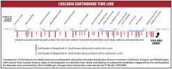
This purports to show the magnitude 9 earthquakes since 8000 BC and clearly shows the THREE magnitude 9 earthquakes estimated since 1000 AD and these appear to line up with the times I stated, 1200, 1600 and 1700. The image also states that the data was provided by Chris Goldfinger.
IF there was an earthquake of Magnitude 9 in or around 1600 that has serious implication for the 15% chance in 50 years - in fact it blows it away completely as far as I can see.
I will be back with the stress calc, as unscientific as it is, later.
edit on 8/3/2012 by PuterMan because: Digital dyslexia
Magnitude 5.1 Iran-Iraq border region
Location in Google Maps
- Date-Time: Thursday, March 08, 2012 at 18:21:38 UTC
Thursday, March 08, 2012 at 09:21:38 PM at epicenter
- Location: 32.913°N, 46.983°E
- Depth: 10 km (6.2 miles)
- Region: IRAN-IRAQ BORDER REGION
- Distances:
93 km [58 miles] SSE [148°] from Ilam, Iran
116 km [72 miles] ENE [66°] from Al-Kut, Iraq
121 km [75 miles] N [353°] from Al-Amarah, Iraq
242 km [150 miles] E [100°] from BAGHDAD, Iraq
- Location Uncertainty: horizontal +/- 14.8 km (9.2 miles); depth +/- 2.8 km (1.7 miles)
- Parameters: NST=152, Nph=154, Dmin=828.2 km, Rmss=1.24 sec, Gp= 58°,M-type=body wave magnitude (Mb), Version=8
- Source: Magnitude: USGS NEIC (WDCS-D)Location: USGS NEIC (WDCS-D)
- Event ID: usb0008dna
Derived from Data Source: USGS
Powered by QVSData
Right on the plate boundary this one. One or two small villages/towns within a 10 mile radius and in this area there can be damage at this level of earthquake. No PAGER data as yet.
Earthquake Report classifies it a not dangerous.
I note they are saying 80km depth against USGS 10km.
EMSC say 50km deep.
edit on 8/3/2012 by PuterMan because: (no reason given)
Magnitude mb 5.5
Region MINDORO, PHILIPPINES
Date time 2012-03-08 20:03:21.8 UTC
Location 13.58 N ; 120.35 E
Depth 80 km
Distances 134 km SW Manila (pop 10,444,527 ; local time 04:03:21.8 2012-03-09)
76 km W Batangas (pop 237,370 ; local time 04:03:21.8 2012-03-09)
42 km SW Calatagan (pop 16,110 ; local time 04:03:21.8 2012-03-09)
17 km NW Harrison (pop 2,349 ; local time 04:03:21.8 2012-03-09)
EMSC
reply to post by muzzy
This is what I was saying to you about magma-xml. It is getting slower and slower. It is now 21:09 and STILL I don't have that quake.
I might have to devise a screen scrape instead of waiting for them.
Universal Time March 8 2012 at 7:09:03
This is what I was saying to you about magma-xml. It is getting slower and slower. It is now 21:09 and STILL I don't have that quake.
I might have to devise a screen scrape instead of waiting for them.
Posted this on this thread earlier, but figured I'd put it here too, so you guys can check it over:
Original Thread: www.abovetopsecret.com...
I also noticed this on the spaceweather.com site.
Space Weather Message Code: SUMSUD
Serial Number: 147
Issue Time: 2012 Mar 08 1109 UTC
SUMMARY: Geomagnetic Sudden Impulse
Observed: 2012 Mar 08 1105 UTC
Deviation: 58 nT
Station: Boulder
www.swpc.noaa.gov...
and another one...
Space Weather Message Code: SUMSUD
Serial Number: 146
Issue Time: 2012 Mar 07 0429 UTC
SUMMARY: Geomagnetic Sudden Impulse
Observed: 2012 Mar 07 0427 UTC
Deviation: 20 nT
Station: Boulder
www.swpc.noaa.gov...
Could this "theory" be related to the theory listed by Wikipedia as a "Geomagnetic Jerk?" Where "these events are believed to be caused by changes in the flow patterns of the liquid outer core of the Earth?" And goes-on to list additional theories these events could also theoretically "due to torsional oscillations in the solid inner core of the Earth...and there have been claims that they are connected to strong earthquakes?"
en.wikipedia.org...
I'll keep looking for additional Geo Sudden Impulses to see if we should really start noticing things...
reply to post by PuterMan
Those short lines are M8 to M8.5 earthquakes in the southern part of Cascadia, not M9s. So they would not affect the Puget Sound or Portland.
You could read this blurb I wrote, which has that same plot, for more details:
pnsn.org...
Those short lines are M8 to M8.5 earthquakes in the southern part of Cascadia, not M9s. So they would not affect the Puget Sound or Portland.
You could read this blurb I wrote, which has that same plot, for more details:
pnsn.org...
Im getting word that there has been a strong quake in china, Will update when i know more?
Southern Xinjiang
Southern Xinjiang
edit on 8-3-2012 by asala because: (no reason given)
new topics
-
This is our Story
General Entertainment: 2 hours ago -
President BIDEN Vows to Make Americans Pay More Federal Taxes in 2025 - Political Suicide.
2024 Elections: 4 hours ago -
Ode to Artemis
General Chit Chat: 5 hours ago -
Ditching physical money
History: 9 hours ago -
One Flame Throwing Robot Dog for Christmas Please!
Weaponry: 9 hours ago -
Don't take advantage of people just because it seems easy it will backfire
Rant: 9 hours ago -
VirginOfGrand says hello
Introductions: 10 hours ago -
Should Biden Replace Harris With AOC On the 2024 Democrat Ticket?
2024 Elections: 10 hours ago
top topics
-
University student disciplined after saying veganism is wrong and gender fluidity is stupid
Education and Media: 13 hours ago, 12 flags -
Police clash with St George’s Day protesters at central London rally
Social Issues and Civil Unrest: 16 hours ago, 9 flags -
President BIDEN Vows to Make Americans Pay More Federal Taxes in 2025 - Political Suicide.
2024 Elections: 4 hours ago, 9 flags -
TLDR post about ATS and why I love it and hope we all stay together somewhere
General Chit Chat: 17 hours ago, 7 flags -
Should Biden Replace Harris With AOC On the 2024 Democrat Ticket?
2024 Elections: 10 hours ago, 6 flags -
Don't take advantage of people just because it seems easy it will backfire
Rant: 9 hours ago, 4 flags -
One Flame Throwing Robot Dog for Christmas Please!
Weaponry: 9 hours ago, 4 flags -
God lived as a Devil Dog.
Short Stories: 14 hours ago, 3 flags -
Ditching physical money
History: 9 hours ago, 3 flags -
VirginOfGrand says hello
Introductions: 10 hours ago, 2 flags
active topics
-
The Reality of the Laser
Military Projects • 33 • : ADVISOR -
Terrifying Encounters With The Black Eyed Kids
Paranormal Studies • 71 • : FlyersFan -
This is our Story
General Entertainment • 1 • : Encia22 -
whistleblower Captain Bill Uhouse on the Kingman UFO recovery
Aliens and UFOs • 17 • : vance2 -
DerBeobachter - Electric Boogaloo 2
Introductions • 13 • : DerBeobachter2 -
One Flame Throwing Robot Dog for Christmas Please!
Weaponry • 7 • : OzBiker -
University student disciplined after saying veganism is wrong and gender fluidity is stupid
Education and Media • 26 • : DerBeobachter2 -
President BIDEN Vows to Make Americans Pay More Federal Taxes in 2025 - Political Suicide.
2024 Elections • 4 • : 727Sky -
British TV Presenter Refuses To Use Guest's Preferred Pronouns
Education and Media • 128 • : Consvoli -
Tucker Carlson UFOs are piloted by spiritual entities with bases under the ocean and the ground
Aliens and UFOs • 42 • : Jukiodone