It looks like you're using an Ad Blocker.
Please white-list or disable AboveTopSecret.com in your ad-blocking tool.
Thank you.
Some features of ATS will be disabled while you continue to use an ad-blocker.

Quake Watch 2012
page: 65share:
Interesting.
source(earthquake.usgs.gov...
Magnitude 4.4
Date-Time Tuesday, March 06, 2012 at 07:13:26 UTC Monday, March 05, 2012 at 10:13:26 PM at epicenter Time of Earthquake in other Time Zones
Location 44.095°N, 129.386°W
Depth 10.3 km (6.4 miles)
Region OFF THE COAST OF OREGON
Distances 424 km (263 miles) WNW of Coos Bay, Oregon 429 km (266 miles) W of Newport, Oregon 473 km (293 miles) WNW of Brookings, Oregon 514 km (319 miles) W of SALEM, Oregon
Location Uncertainty horizontal +/- 18.5 km (11.5 miles); depth +/- 2.9 km (1.8 miles) Parameters NST=167, Nph=177, Dmin=430.8 km, Rmss=1.41 sec, Gp= 94°, M-type=body wave magnitude (Mb), Version=5
Magnitude mb 5.3
Region SOUTHERN SUMATRA, INDONESIA
Date time 2012-03-06 11:36:23.0 UTC
Location 0.80 S ; 100.10 E
Depth 100 km
Distances 32 km NW Padang (pop 840,352 ; local time 18:36:23.8 2012-03-06)
19 km S Padang pariaman (pop 92,183 ; local time 18:36:23.8 2012-03-06)
EMSC
source(www.ubalert.com...
tA moderately strong earthquake cracked buildings and knocked televisions and glassware from tables Tuesday in a central Philippine province, injuring at least 10 people and sending others rushing outside in panic, officials said.
The quake came a month after 58 people died in a quake on another Philippine island. Renato Solidum of the Philippine Institute of Volcanology and Seismology said the quake with a preliminary magnitude of 5.2 struck Tuesday morning and was centered at sea just two miles (three kilometers) north of Masbate City on the island province of Masbate.
The quake, which was caused by movement in a local fault, was felt in nearby provinces. Masbate City Mayor Socrates Tuason told The Associated Press by telephone that there were no reports of major damage, and power and communications were not affected by the temblor in his hillside city of 90,000 people. But the quake caused an abandoned three-story building to collapse and shattered glass windows in houses and other buildings, at least two of which were cleared of people and cordoned off by police while government engineers checked their stability.
Large numbers of people rushed out of homes, offices, hospitals and schools and stayed in the streets as a number of aftershocks rattled nerves after the quake. Several restaurants, shops and banks also had visible cracks and did not open Tuesday, officials said. At least 10 people were slightly injured by falling objects and collapsing walls, officials said. "I was having breakfast with my wife when everything started to shake. The TV set and glasses fell off the table," Tuason said. "When I got out, I saw all the people in the community were on the streets." Disaster-response and first aid teams were deployed across the city, Tuason said. Classes in all schools were suspended as buildings were checked for damage, he said, adding that he had called an emergency meeting to deal with any contingency. Officials of Masbate, about 220 miles (350 kilometers) southeast of Manila, led earthquake drills in schools and offices just last week after a magnitude-6.9 quake left 58 people dead, 60 others missing and displaced more than 200,000 on nearby Negros island on Feb. 6. Leo Jasareno, who heads a government agency that produces hazard maps for communities, said Tuesday's earthquake should serve as the latest warning for thousands of people to stop ignoring advice to immediately evacuate from more than 7,000 mountain villages nationwide that are prone to landslides set off by earthquakes or storms.
Several residential areas also dangerously sit on and near active fault zones, including in metropolitan Manila, but people have ignored the risks, officials said. The Philippines is in the so-called Pacific "Ring of Fire," where earthquakes and volcanic activity are common. The damage and casualties are compounded by poor construction in violation of building codes in the impoverished nation.
So....does anyone think that magma is on the move in Northwest US?
Im wondering....
Im wondering....
reply to post by MamaJ
Here is my $.02, FWIW.
I think there is certainly magma moving at depth under parts for the PNW. Under places like Mt. Rainier, Mt. Shasta, and Lassen Peak--something is causing the fumaroles, hot springs and mud pots--hot molten rock..
But a lot of that hot rock is cooling into granitic plutons in the crust, before making it to the surface as a volcanic eruption. In the future, erosion may expose that cooled, frozen magma, but it will be thousands of years after we are gone.
Originally posted by Olivine
reply to post by MamaJ
Here is my $.02, FWIW.
I think there is certainly magma moving at depth under parts for the PNW. Under places like Mt. Rainier, Mt. Shasta, and Lassen Peak--something is causing the fumaroles, hot springs and mud pots--hot molten rock..
But a lot of that hot rock is cooling into granitic plutons in the crust, before making it to the surface as a volcanic eruption. In the future, erosion may expose that cooled, frozen magma, but it will be thousands of years after we are gone.
Thanks so much...i was beginning to wonder how or if it was possible to know or find out what is going on in that part of the states.
I watched this today at lunch...was pretty cool and pretty surreal. Living in TN I have to wonder too..when and if this sucker will crack and ponder if it will be in my lifetime.
Magnitude mb 5.0
Region KURIL ISLANDS
Date time 2012-03-06 22:33:18.0 UTC
Location 47.21 N ; 154.14 E
Depth 40 km
Distances 721 km SW Petropavlovsk-kamchatskiy (pop 187,282 ; local time 10:33:18.8 2012-03-07)
725 km SW Mokhovaya, petropavlovsk-kamch (pop 22,815 ; local time 10:33:18.8 2012-03-07)
412 km S Severo-kurilsk (pop 2,286 ; local time 09:33:18.8 2012-03-07)
EMSC
Originally posted by slidingdoor
Don't remember seeing this region pop up too often ?
Persian Gulf...3.7
www.emsc-csem.org...
according to EMSC, it's the first one after two years. So yes it is a rare location
just popped in to say pretty quiet here in NZ.
Didn't feel this one the other night in Cook Strait, you can see the location from my beach
Reference Number 3669262
Universal Time March 5 2012 at 10:04
NZ Daylight Time Monday, March 5 2012 at 11:04 pm
Latitude, Longitude 41.17°S, 174.47°E
Focal Depth 40 km
Richter magnitude 4.0
Region Marlborough
Location
30 km north-west of Wellington
www.geonet.org.nz...
also Geonet Rapid Beta version has been released
beta.geonet.org.nz...
I kind of like how they give a list of recent previous quakes at each location
go ahead and click on one of the events to see what I mean.
edit on 6-3-2012 by muzzy because: (no reason given)
reply to post by muzzy
I like it Muzzy!
Thanks for the link as I rarely visit the GeoNet site these days, preferring to watch quakes on globalincentmap.com
I like it Muzzy!
Thanks for the link as I rarely visit the GeoNet site these days, preferring to watch quakes on globalincentmap.com
Puterman, trueamerican.... You may have addressed this, so my apologies...but what are your thoughts on the theory of the seemingly endless CME's
causing the quakes of late?
I'm just curious to your opinions as I have the utmost respect and gratitude for your contributions.
I'm just curious to your opinions as I have the utmost respect and gratitude for your contributions.
edit on 7-3-2012 by amongus because: (no reason given)
edit on 7-3-2012 by amongus because: (no reason given)
reply to post by amongus
I suppose the first point and question would be "quakes of late?". Are there any more now than in say the last 10 years?
Aside from the obvious after effects of Tohoku-Oki the answer must be no. Of course that is not the perception since everyone gets excited about every quake these days ( ) but the fact remains that activity generally is not significantly higher than it has been,
So what of CMEs then? Well again the Sun despite supposedly ramping up for a Solar Max could do with a quick burst of nitro or it is going to end up as a very damp squib. So is there a connection with CMEs? Don't know. There may be but as with so many of these things it has passed into folk lore and is considered to be true when in fact no definitive study has actually proved a connection.
Not to say there is not one, just that no one has come up with the goods yet.
Here is the problem:
There is an X Class flare heading this way that may hit a glancing blow. If a mag 6+ earthquake also happens to go off then it will be attributed to the X Class flare. If there is no flare hanging around in the wings, but there is a full / new / super / blue / black or pink moon, apogee or perigee then it will be attributed to that. Failing that people will look for planetary alignments, and failing that for comets or asteroids.If none of those events are apparent or imminent the cause won't be mentioned or it will be because of HAARP.
I hate to think what would be said it we had an X5, super-moon, large comet, asteroid and haemorrhoid all at the same time. Obviously it would cause a Mag 10.
As it happens, and I have said this before, I think that it seems quieter earthquake-wise when there are CMEs, but that is just folk lore, a feeling, and I have no definitive data to back that up so basically it should be ignored.
Puterman, trueamerican.... You may have addressed this, so my apologies...but what are your thoughts on the theory of the seemingly endless CME's causing the quakes of late?
I suppose the first point and question would be "quakes of late?". Are there any more now than in say the last 10 years?
Aside from the obvious after effects of Tohoku-Oki the answer must be no. Of course that is not the perception since everyone gets excited about every quake these days ( ) but the fact remains that activity generally is not significantly higher than it has been,
So what of CMEs then? Well again the Sun despite supposedly ramping up for a Solar Max could do with a quick burst of nitro or it is going to end up as a very damp squib. So is there a connection with CMEs? Don't know. There may be but as with so many of these things it has passed into folk lore and is considered to be true when in fact no definitive study has actually proved a connection.
Not to say there is not one, just that no one has come up with the goods yet.
Here is the problem:
There is an X Class flare heading this way that may hit a glancing blow. If a mag 6+ earthquake also happens to go off then it will be attributed to the X Class flare. If there is no flare hanging around in the wings, but there is a full / new / super / blue / black or pink moon, apogee or perigee then it will be attributed to that. Failing that people will look for planetary alignments, and failing that for comets or asteroids.If none of those events are apparent or imminent the cause won't be mentioned or it will be because of HAARP.
I hate to think what would be said it we had an X5, super-moon, large comet, asteroid and haemorrhoid all at the same time. Obviously it would cause a Mag 10.
As it happens, and I have said this before, I think that it seems quieter earthquake-wise when there are CMEs, but that is just folk lore, a feeling, and I have no definitive data to back that up so basically it should be ignored.
Now, on the subject of the next Mag 6+ to go of in concert with a CME or whatever I am trying to come up with a method of at least determining which
areas might be under notice.
I have looked at three so far, but can't go too much further until with muzzy we have examined all the FE geographical areas and defined better seismic areas if need be. (And there is a need in some cases)
I am not going to go into great detail here as it is long winded and requires a spreadsheet to explain it.
For all areas take the period 1900 to current. For each month in that time span calculate the energy of Mag 5, or Mag 6 (makes little or no difference as I have shown) and revert the energy to a magnitude equivalent. The top 3 values become the MV values for the area.
The average energy for a month is calculated and the stress is built in the fashion I have showed you before to create the sawtooth graphs.
I devised a method of weighting, really by experiment, that just happens to match the potential stress levels and gives me an alert level of between 0 and 7
Having tried this on three areas now it appears to pan out like this.
Level 0 - Any magnitude under the threshold of Maximum Possible can occur at any time.
Level 1 - An MV 1 event is possible (The third known biggest for the area)
Levels 2 to 4 incleasing possibilities fro MV 1
Level 5 - An MV 2 event is now possible (The second known biggest for the area)
Level 6 - An MV 3 event is now possible, but not imminent necessarily. (The biggest known for the area)
Level 7 - An MV 3 event WILL occur within 6 months or so (unless mitigated by a lower level event.)
This is very woolly as for instance Ryukyu Islands which I have just done has been on level 6 for some time - in fact since 1997. There were months with 6.52 EMV (Equivalent Magnitude Value) and 6.78 EMV but these did not affect the level 6 status. (Sometime it can get pulled down a level by a bigger quake.)
From 1997 to now is a long time to be saying you could be seeing a mag 7.7 (The max for the area) and I don't know if there is a way to refine this further to give a better indication. I think the problem is that I don't have a clue how to work out just which of the three max events will happen, only the they are possible.
So far the only certain on seems to be a level 7. If an area gets to that there WILL be an MV 3 event.
I suppose it is a start and maybe further refinement will cut down the timespans a bit.
I have made a GIF image from the spreadsheet for Ryukyu but be advised it is 1.6 MB so large for dial-up connections.
Click to expand it when loaded. It is 27000+ pixels long by just under 900 pixels wide.
What this will not take into account is that during the 110 or so years the dynamics of a region may have changed - I will have to look into that.
Here is the sawtooth for Ryukyu. (Sorry no mag equivalents on this one as I have to shoot out.)
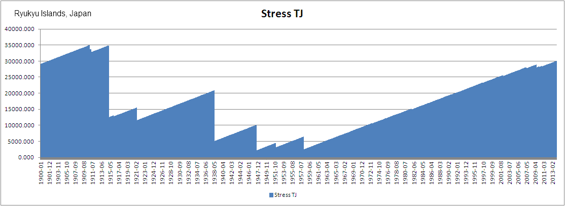
ETA: PEBuild is wrong until the first MV event. I have to devise the method of correcting that.
I have looked at three so far, but can't go too much further until with muzzy we have examined all the FE geographical areas and defined better seismic areas if need be. (And there is a need in some cases)
I am not going to go into great detail here as it is long winded and requires a spreadsheet to explain it.
For all areas take the period 1900 to current. For each month in that time span calculate the energy of Mag 5, or Mag 6 (makes little or no difference as I have shown) and revert the energy to a magnitude equivalent. The top 3 values become the MV values for the area.
The average energy for a month is calculated and the stress is built in the fashion I have showed you before to create the sawtooth graphs.
I devised a method of weighting, really by experiment, that just happens to match the potential stress levels and gives me an alert level of between 0 and 7
Having tried this on three areas now it appears to pan out like this.
Level 0 - Any magnitude under the threshold of Maximum Possible can occur at any time.
Level 1 - An MV 1 event is possible (The third known biggest for the area)
Levels 2 to 4 incleasing possibilities fro MV 1
Level 5 - An MV 2 event is now possible (The second known biggest for the area)
Level 6 - An MV 3 event is now possible, but not imminent necessarily. (The biggest known for the area)
Level 7 - An MV 3 event WILL occur within 6 months or so (unless mitigated by a lower level event.)
This is very woolly as for instance Ryukyu Islands which I have just done has been on level 6 for some time - in fact since 1997. There were months with 6.52 EMV (Equivalent Magnitude Value) and 6.78 EMV but these did not affect the level 6 status. (Sometime it can get pulled down a level by a bigger quake.)
From 1997 to now is a long time to be saying you could be seeing a mag 7.7 (The max for the area) and I don't know if there is a way to refine this further to give a better indication. I think the problem is that I don't have a clue how to work out just which of the three max events will happen, only the they are possible.
So far the only certain on seems to be a level 7. If an area gets to that there WILL be an MV 3 event.
I suppose it is a start and maybe further refinement will cut down the timespans a bit.
I have made a GIF image from the spreadsheet for Ryukyu but be advised it is 1.6 MB so large for dial-up connections.
Click to expand it when loaded. It is 27000+ pixels long by just under 900 pixels wide.
What this will not take into account is that during the 110 or so years the dynamics of a region may have changed - I will have to look into that.
Here is the sawtooth for Ryukyu. (Sorry no mag equivalents on this one as I have to shoot out.)
ETA: PEBuild is wrong until the first MV event. I have to devise the method of correcting that.
edit on 7/3/2012 by PuterMan because: (no reason given)
source(earthquake.usgs.gov...
Magnitude 5.5
Date-Time Wednesday, March 07, 2012 at 12:00:45 UTC Wednesday, March 07, 2012 at 09:00:45 PM at epicenter
Location 2.762°S, 138.871°E
Depth 43.8 km (27.2 miles)
Region PAPUA, INDONESIA
Distances 205 km (127 miles) W (263°) from Jayapura, Irian Jaya, Indonesia 268 km (167 miles) W (268°) from Vanimo, New Guinea, PNG 306 km (190 miles) ENE (68°) from Enarotali, Irian Jaya, Indonesia 1184 km (736 miles) NW (308°) from PORT MORESBY, Papua New Guinea
Location Uncertainty horizontal +/- 17.1 km (10.6 miles); depth +/- 8.3 km (5.2 miles)
Parameters NST=131, Nph=137, Dmin=736.9 km, Rmss=0.87 sec, Gp= 65°, M-type=body wave magnitude (Mb), Version=5
Magnitude mb 5.6
Region SOUTH SANDWICH ISLANDS REGION
Date time 2012-03-07 12:02:53.2 UTC
Location 57.90 S ; 25.44 W
Depth 63 km
Distances 3116 km SE Comodoro rivadavia (pop 140,850 ; local time 09:02:53.2 2012-03-07)
2841 km SE Río gallegos (pop 85,700 ; local time 09:02:53.2 2012-03-07)
2162 km SE Port stanley (pop 2,213 ; local time 09:02:53.2 2012-03-07)
EMSC
This latest series of strong CME's and flares;
combined with the relative dead period of preceding month;
might be a good period to compare both flare energy and quake releases.
However it is noteworthy that earthquakes already picked up in number (particular 4.5+) and energy over this past week; even BEFORE that first X1.1 took place on the sun.
Personally I do not expect major Geological effects caused by the large amount of Solar Energy which should hit us in next two to three days. But mind is open, let us see. Not only is is that X5.4 of today but the total amount of energy coming our way since the sudden X1.1 on 5 March - which by the way is already pushing the Magnetosphere like a beach ball under a sitting elephant.
just talking to myself for a minute
The minimum residual value at the bottom of the sawtooth graph looks as if ideally if should be about 1 full point below the MV 1 level thus with an MV 1 of 7.4 Ryukyu would have an ideal Min residual value of 251 TJ - a Mag 6.4
It can of course go lower, but must never go negative.
Adjusting the chart I produced so that the starting value allows a residual of Mag 6.4 in 1947 - the lowest point - this brings the onset of level 6 to 1999.
I won't bore you with any more as your eyes are probably glazed over already!
reply to post by Aromaz
Ah Aromaz, I hate to do this to you!
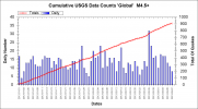
Um, nope. They have decreased. First Mag 4.5 to Mag 10 worldwide daily counts
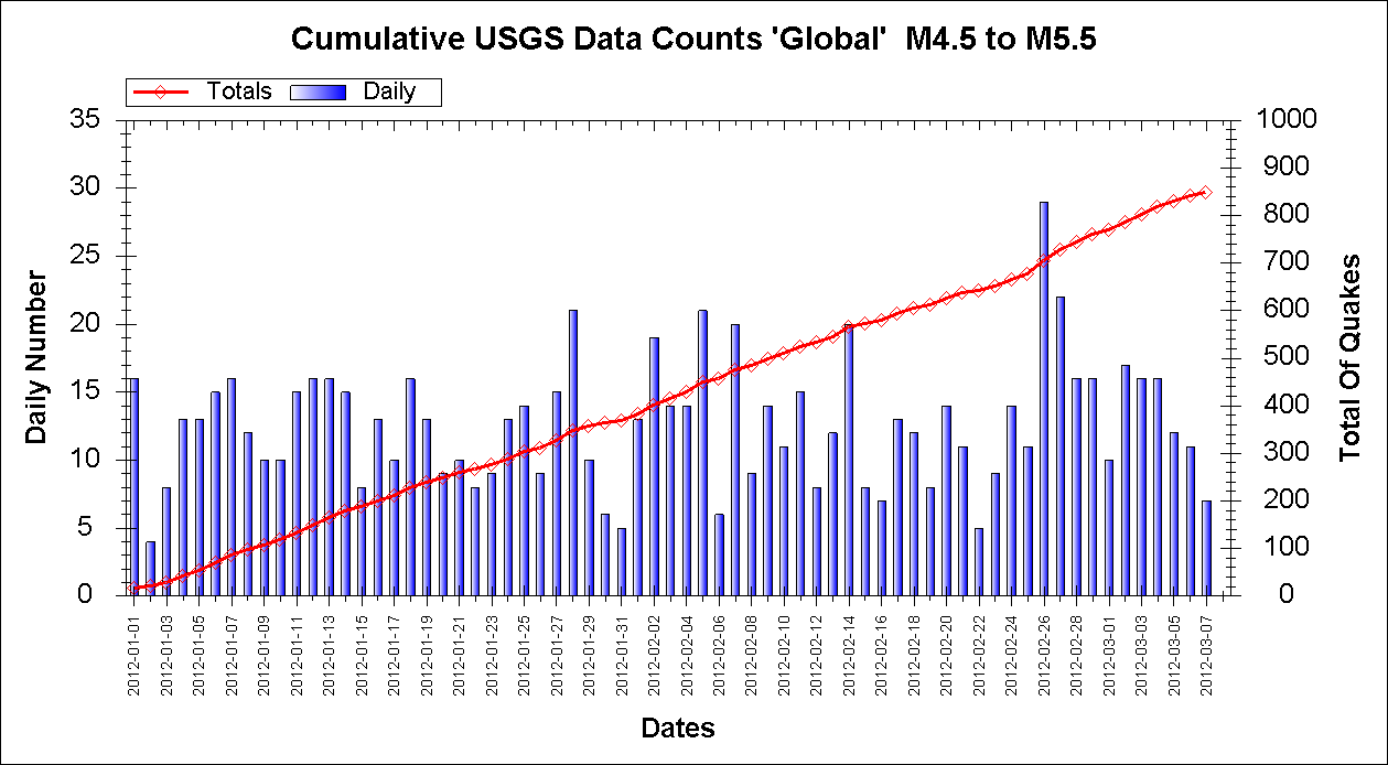
Then just to be sure Mag 4.5 to 5.5 daily counts
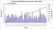
Both show a clear drop in the past couple of weeks.
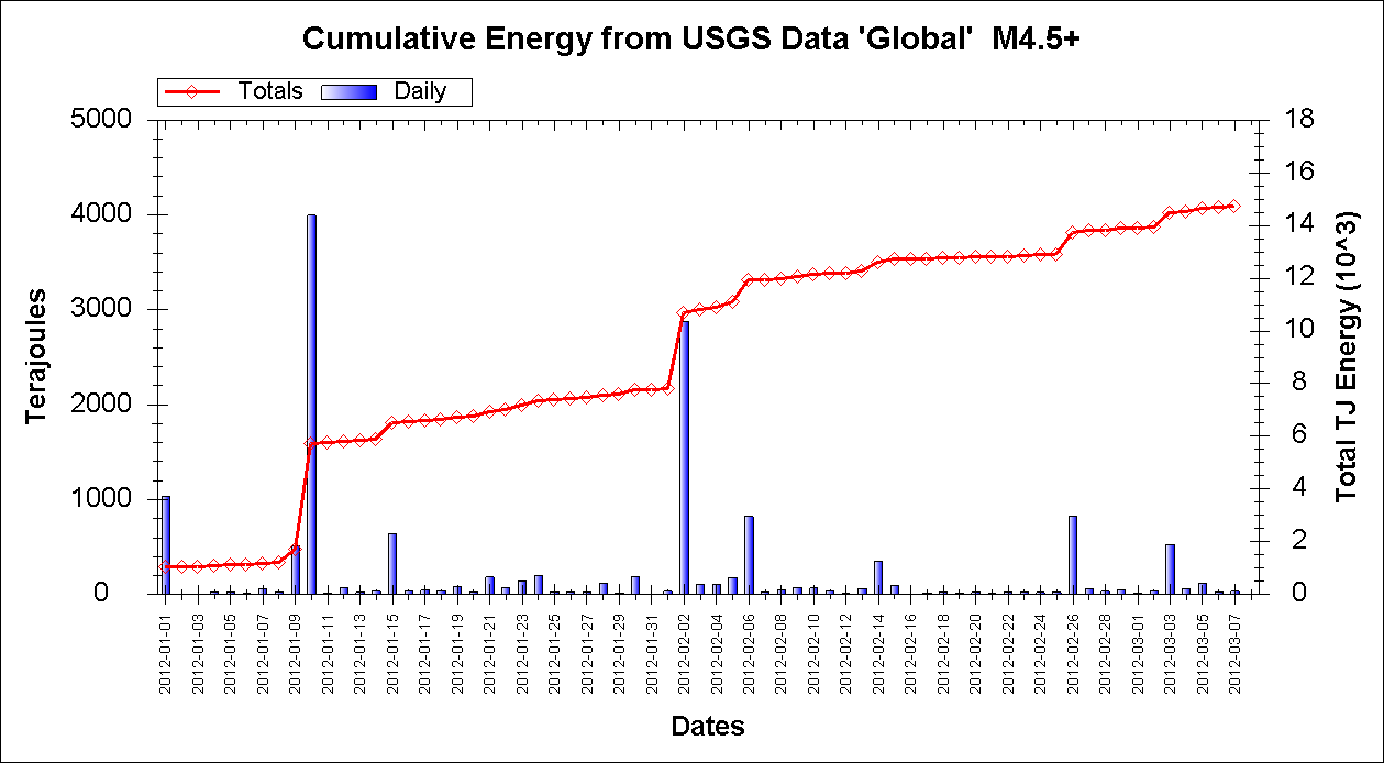
Since energy can be different. Mag 4.5+

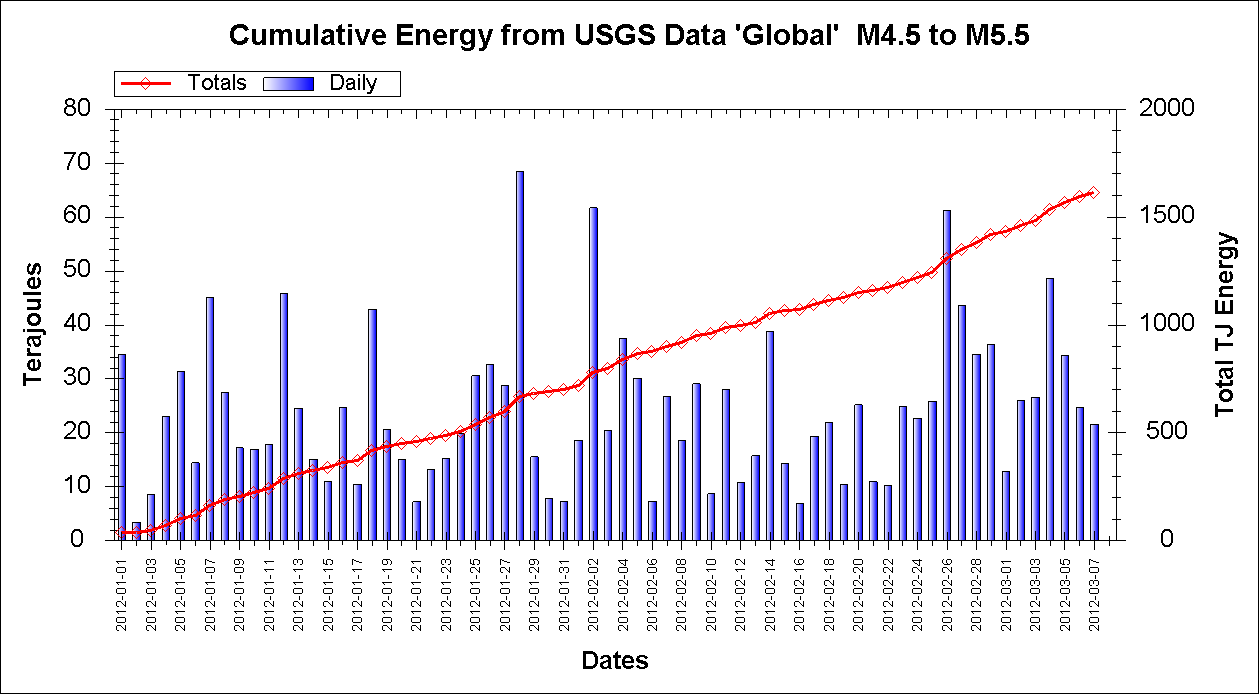
and Mag 4.5 to 5.5. You might be more correct here in that there was an increase, but that too has dropped off over the last 4 days.

Ah Aromaz, I hate to do this to you!
However it is noteworthy that earthquakes already picked up in number (particular 4.5+) and energy over this past week
Um, nope. They have decreased. First Mag 4.5 to Mag 10 worldwide daily counts
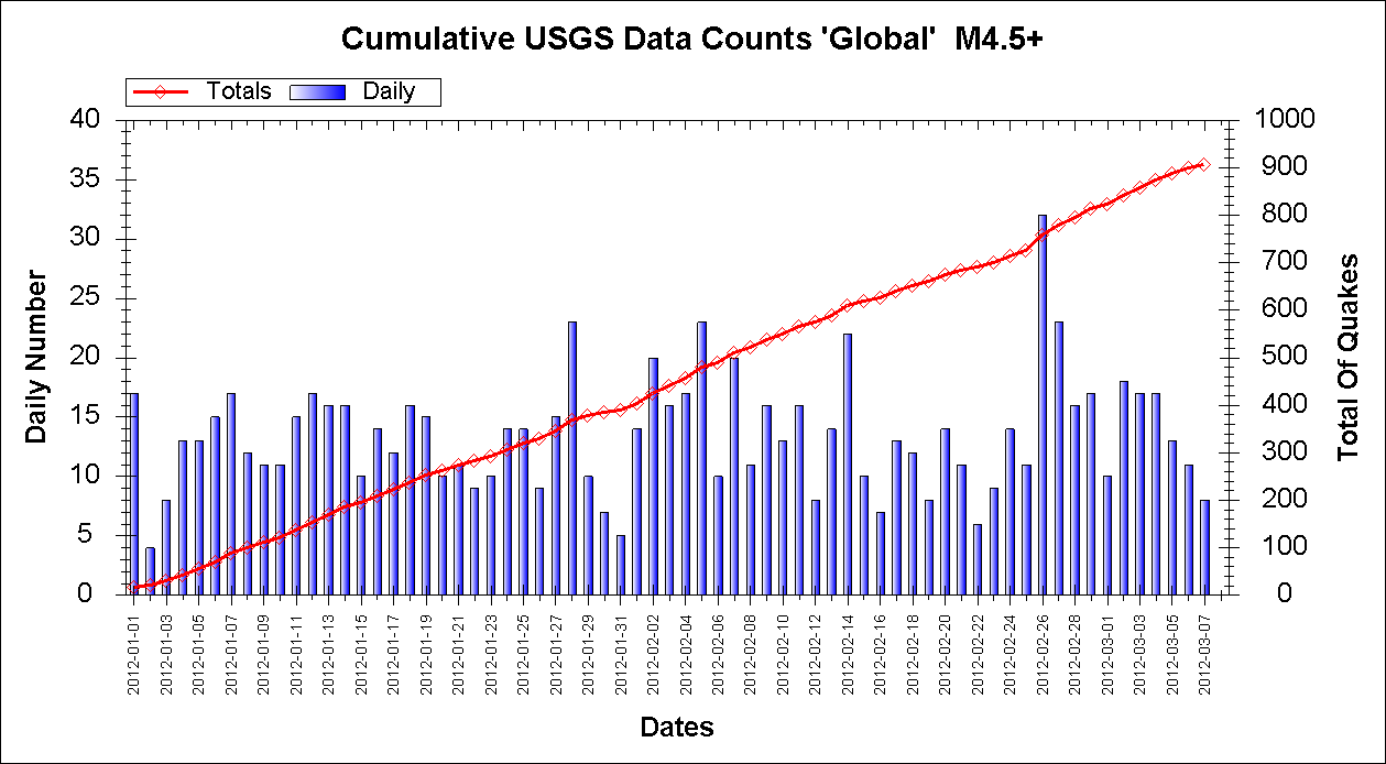
Then just to be sure Mag 4.5 to 5.5 daily counts
Both show a clear drop in the past couple of weeks.
Since energy can be different. Mag 4.5+
and Mag 4.5 to 5.5. You might be more correct here in that there was an increase, but that too has dropped off over the last 4 days.
edit on 7/3/2012 by PuterMan because: (no reason given)
Magnitude mb 5.0
Region VANUATU
Date time 2012-03-07 13:56:00.3 UTC
Location 19.43 S ; 168.15 E
Depth 4 km
Distances 1781 km NE Brisbane (pop 1,843,392 ; local time 23:56:00.3 2012-03-07)
1092 km W Suva (pop 199,455 ; local time 01:56:00.3 2012-03-08)
189 km S Vila (pop 35,901 ; local time 00:56:00.3 2012-03-08)
119 km W Isangel (pop 1,437 ; local time 00:56:00.3 2012-03-08)
EMSC
new topics
-
HORRIBLE !! Russian Soldier Drinking Own Urine To Survive In Battle
World War Three: 1 hours ago -
Bobiverse
Fantasy & Science Fiction: 4 hours ago -
Florida man's trip overseas ends in shock over $143,000 T-Mobile phone bill
Social Issues and Civil Unrest: 4 hours ago -
Former Labour minister Frank Field dies aged 81
People: 6 hours ago -
SETI chief says US has no evidence for alien technology. 'And we never have'
Aliens and UFOs: 8 hours ago -
This is our Story
General Entertainment: 11 hours ago
top topics
-
President BIDEN Vows to Make Americans Pay More Federal Taxes in 2025 - Political Suicide.
2024 Elections: 13 hours ago, 16 flags -
SETI chief says US has no evidence for alien technology. 'And we never have'
Aliens and UFOs: 8 hours ago, 6 flags -
Florida man's trip overseas ends in shock over $143,000 T-Mobile phone bill
Social Issues and Civil Unrest: 4 hours ago, 6 flags -
Ditching physical money
History: 17 hours ago, 4 flags -
Former Labour minister Frank Field dies aged 81
People: 6 hours ago, 4 flags -
Ode to Artemis
General Chit Chat: 14 hours ago, 3 flags -
This is our Story
General Entertainment: 11 hours ago, 3 flags -
Bobiverse
Fantasy & Science Fiction: 4 hours ago, 3 flags -
HORRIBLE !! Russian Soldier Drinking Own Urine To Survive In Battle
World War Three: 1 hours ago, 1 flags
active topics
-
University student disciplined after saying veganism is wrong and gender fluidity is stupid
Education and Media • 47 • : Consvoli -
-@TH3WH17ERABB17- -Q- ---TIME TO SHOW THE WORLD--- -Part- --44--
Dissecting Disinformation • 647 • : daskakik -
Florida man's trip overseas ends in shock over $143,000 T-Mobile phone bill
Social Issues and Civil Unrest • 6 • : Cre8chaos79 -
Election Year 2024 - Interesting Election-Related Tidbits as They Happen.
2024 Elections • 72 • : Threadbarer -
President BIDEN Vows to Make Americans Pay More Federal Taxes in 2025 - Political Suicide.
2024 Elections • 68 • : Boomer1947 -
HORRIBLE !! Russian Soldier Drinking Own Urine To Survive In Battle
World War Three • 9 • : budzprime69 -
Thousands Of Young Ukrainian Men Trying To Flee The Country To Avoid Conscription And The War
Other Current Events • 131 • : Consvoli -
American Government to Sanction Israel Defence Force in the West Bank
Middle East Issues • 54 • : yuppa -
Breaking Baltimore, ship brings down bridge, mass casualties
Other Current Events • 478 • : IndieA -
Russia Ukraine Update Thread - part 3
World War Three • 5726 • : stu119