It looks like you're using an Ad Blocker.
Please white-list or disable AboveTopSecret.com in your ad-blocking tool.
Thank you.
Some features of ATS will be disabled while you continue to use an ad-blocker.

Quake Watch 2012
page: 207share:
Updated Quake List:
Update time = Mon Aug 27 2:26:40 UTC 2012
MAG UTC DATE-TIME
y/m/d h:m:s LAT
deg LON
deg DEPTH
km Region
3.4 2012/08/27 00:58:45 32.998 -115.579 13.0 SOUTHERN CALIFORNIA
3.4 2012/08/27 00:58:34 33.018 -115.539 0.1 SOUTHERN CALIFORNIA
2.9 2012/08/27 00:13:45 33.005 -115.596 18.0 SOUTHERN CALIFORNIA
2.9 2012/08/27 00:12:26 33.037 -115.549 8.9 SOUTHERN CALIFORNIA
MAG UTC DATE-TIME
y/m/d h:m:s LAT
deg LON
deg DEPTH
km Region
3.2 2012/08/26 23:53:15 33.033 -115.535 13.5 SOUTHERN CALIFORNIA
3.8 2012/08/26 23:36:58 33.052 -115.533 7.7 SOUTHERN CALIFORNIA
3.4 2012/08/26 23:34:51 33.001 -115.547 5.2 SOUTHERN CALIFORNIA
4.8 2012/08/26 23:33:25 33.039 -115.523 12.2 SOUTHERN CALIFORNIA
2.7 2012/08/26 23:21:05 33.021 -115.541 13.3 SOUTHERN CALIFORNIA
2.6 2012/08/26 23:16:22 33.007 -115.564 13.0 SOUTHERN CALIFORNIA
2.6 2012/08/26 23:13:46 33.032 -115.536 12.9 SOUTHERN CALIFORNIA
4.3 2012/08/26 22:58:42 33.002 -115.591 12.9 SOUTHERN CALIFORNIA
3.4 2012/08/26 22:53:36 33.023 -115.553 12.5 SOUTHERN CALIFORNIA
3.4 2012/08/26 22:52:10 32.998 -115.589 12.4 SOUTHERN CALIFORNIA
2.5 2012/08/26 22:51:34 40.304 -124.429 11.0 OFFSHORE NORTHERN CALIFORNIA
2.5 2012/08/26 22:51:23 32.997 -115.570 0.1 SOUTHERN CALIFORNIA
3.5 2012/08/26 22:34:46 33.007 -115.589 13.6 SOUTHERN CALIFORNIA
2.8 2012/08/26 22:34:05 32.992 -115.593 13.9 SOUTHERN CALIFORNIA
3.0 2012/08/26 22:23:57 32.989 -115.428 6.0 SOUTHERN CALIFORNIA
2.8 2012/08/26 22:22:54 32.923 -115.555 12.3 SOUTHERN CALIFORNIA
2.8 2012/08/26 22:22:35 32.962 -115.564 12.7 SOUTHERN CALIFORNIA
2.8 2012/08/26 22:16:23 32.983 -115.485 9.5 SOUTHERN CALIFORNIA
2.7 2012/08/26 22:16:03 32.938 -115.669 0.0 SOUTHERN CALIFORNIA
2.7 2012/08/26 22:13:04 32.999 -115.578 15.8 SOUTHERN CALIFORNIA
2.8 2012/08/26 22:08:06 33.021 -115.549 14.1 SOUTHERN CALIFORNIA
3.4 2012/08/26 22:06:29 33.014 -115.539 9.6 SOUTHERN CALIFORNIA
3.0 2012/08/26 22:02:00 33.028 -115.541 13.4 SOUTHERN CALIFORNIA
3.0 2012/08/26 21:54:16 33.004 -115.586 16.2 SOUTHERN CALIFORNIA
3.0 2012/08/26 21:53:58 32.971 -115.551 14.8 SOUTHERN CALIFORNIA
2.7 2012/08/26 21:47:18 33.026 -115.538 10.9 SOUTHERN CALIFORNIA
3.1 2012/08/26 21:46:12 32.996 -115.591 12.5 SOUTHERN CALIFORNIA
2.5 2012/08/26 21:45:26 32.967 -115.551 13.1 SOUTHERN CALIFORNIA
2.9 2012/08/26 21:42:51 33.022 -115.541 11.5 SOUTHERN CALIFORNIA
2.5 2012/08/26 21:37:50 33.051 -115.577 0.0 SOUTHERN CALIFORNIA
2.7 2012/08/26 21:34:48 33.027 -115.532 11.8 SOUTHERN CALIFORNIA
2.5 2012/08/26 21:30:55 33.005 -115.565 12.4 SOUTHERN CALIFORNIA
3.8 2012/08/26 21:26:40 33.038 -115.527 12.4 SOUTHERN CALIFORNIA
3.5 2012/08/26 21:23:24 32.999 -115.590 14.3 SOUTHERN CALIFORNIA
3.6 2012/08/26 21:23:11 32.973 -115.599 8.5 SOUTHERN CALIFORNIA
2.5 2012/08/26 21:22:36 33.116 -115.958 5.6 SOUTHERN CALIFORNIA
2.9 2012/08/26 21:21:57 32.998 -115.549 0.3 SOUTHERN CALIFORNIA
2.9 2012/08/26 21:21:22 32.970 -115.588 12.9 SOUTHERN CALIFORNIA
2.6 2012/08/26 21:20:24 33.032 -115.524 4.3 SOUTHERN CALIFORNIA
2.8 2012/08/26 21:20:06 33.022 -115.536 10.0 SOUTHERN CALIFORNIA
2.5 2012/08/26 21:19:35 32.974 -115.561 1.4 SOUTHERN CALIFORNIA
2.7 2012/08/26 21:19:01 33.013 -115.536 0.0 SOUTHERN CALIFORNIA
3.9 2012/08/26 21:17:27 32.986 -115.603 11.8 SOUTHERN CALIFORNIA
4.2 2012/08/26 21:15:29 33.042 -115.539 9.1 SOUTHERN CALIFORNIA
2.8 2012/08/26 21:13:59 33.026 -115.524 11.9 SOUTHERN CALIFORNIA
2.9 2012/08/26 21:12:38 32.959 -115.585 0.0 OUTHERN CALIFORNIA
edit on 26-8-2012 by kennvideo because: info
reply to post by muzzy
Hey there Muzzy!!! Glad you are in the mix adding valuable info as always. I'm wondering that you posted us for Brawley only so the stats are not taking the town Westmoreland into account,for instance?
Hey there Muzzy!!! Glad you are in the mix adding valuable info as always. I'm wondering that you posted us for Brawley only so the stats are not taking the town Westmoreland into account,for instance?
Series of Earthquakes Rattle Southern California
SAN DIEGO August 26, 2012 (AP)
abcnews.go.com/US/wireStory/series-earthquakes-rattle-california-17083595
SAN DIEGO August 26, 2012 (AP)
abcnews.go.com/US/wireStory/series-earthquakes-rattle-california-17083595
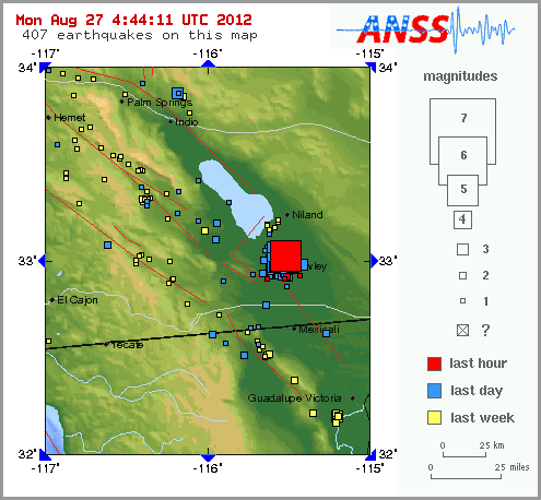
Dozens of small to moderate earthquakes struck the southeastern corner of California on Sunday, causing minor damages to structures and rattling nerves in a small farming town east of San Diego.
The largest quake registered at a magnitude 5.5 and was centered about three miles northwest of the town of Brawley, said Robert Graves, a geophysicist with the U.S. Geological Survey. Another quake Sunday registered at magnitude 5.3.
More than 30 additional earthquakes with magnitudes of at least 3.5 jiggled the same area near the southern end of the Salton Sea, Graves said.
"The type of activity that we're seeing could possibly continue for several hours or even days," Graves said.
At the El Sol Market in Brawley, food packages fell from the shelves, littering aisle ways.
Several glasses and a bottle of wine crashed to the floor and shattered at Assaggio, an Italian restaurant in Brawley, said owner Jerry Ma. The shaking was short-lived but intense, he said.
"It felt like there was quake every 15 minutes. One after another. My kids are small and they're scared and don't want to come back inside," said Mike Patel, who manages Townhouse Inn & Suites in Brawley.
A TV came crashing down and a few light fixtures broke inside the motel, Patel said.
A Brawley Police Department dispatcher said several downtown buildings sustained minor damage. No injuries were reported.
The first quake, with a magnitude of 3.9, occurred at 10:02 a.m. The USGS said more than 100 aftershocks struck the same approximate epicenter, about 16 miles north of El Centro.
Some shaking was felt along the San Diego County coast in Del Mar, some 120 miles from the epicenter, as well as in the Coachella Valley, southern Orange County and parts of northern Mexico.
USGS seismologist Lucy Jones said earthquake swarms are characteristic of the region, known as the Brawley Seismic Zone.
"The area sees lots of events at once, with many close to the largest magnitude, rather than one main shock with several much smaller aftershocks," Jones said.
The last major swarm was in 2005, following a magnitude-5.1 quake, she said.
Sunday's quake cluster occurred in what scientists call a transition zone between the Imperial and San Andreas faults, so they weren't assigning the earthquakes to either fault, Graves said.
Here is the link for the live "Quake Cam" from KABC in Los Angeles in case anybody would like to watch.
abclocal.go.com...
abclocal.go.com...
reply to post by MamaJ
yep westmorland is in there
pages are flipping too quick here on ATS,
I edited my post to say i found another 165 quakes that anmarie pointed me to below2.5, I'll do another map.
easy now I have the programme set up with the parameters
yep westmorland is in there
pages are flipping too quick here on ATS,
I edited my post to say i found another 165 quakes that anmarie pointed me to below2.5, I'll do another map.
easy now I have the programme set up with the parameters
7.4 2012/08/27 04:37:22 12.220 -88.529 50.6 OFF THE COAST OF EL SALVADOR
earthquake.usgs.gov...
no tsunami expected:
ptwc.weather.gov...
Not that unusual for the area:
neic.usgs.gov...
lol, if I hadn't been so caught up in the Cali swarm, I would have seen it on my other screen- had it open too..
earthquake.usgs.gov...
no tsunami expected:
ptwc.weather.gov...
edit on Sun Aug 26th 2012 by TrueAmerican because: (no reason
given)
Not that unusual for the area:
neic.usgs.gov...
edit on Mon Aug 27th 2012 by TrueAmerican because: (no reason given)
lol, if I hadn't been so caught up in the Cali swarm, I would have seen it on my other screen- had it open too..
edit on Mon Aug 27th 2012
by TrueAmerican because: (no reason given)
earthquake.usgs.gov...
I keep refreshing every few minutes, imagine my surprise, not! Twas expected eh?
BTW I am moving to Phoenix in 5 weeks!!!!!!!!!
This event has been reviewed by a seismologist.
Magnitude
5.1
Date-Time
Monday, August 27, 2012 at 04:41:37 UTC
Sunday, August 26, 2012 at 09:41:37 PM at epicenter
Location
33.031°N, 115.528°W
Depth
10.2 km (6.3 miles)
Region
SOUTHERN CALIFORNIA
Distances
6 km (4 miles) N (8°) from Brawley, CA
9 km (6 miles) E (95°) from Westmorland, CA
11 km (7 miles) S (188°) from Calipatria, CA
27 km (17 miles) N (6°) from El Centro, CA
150 km (93 miles) ENE (68°) from Tijuana, Baja California, Mexico
Location Uncertainty
horizontal +/- 0.5 km (0.3 miles); depth +/- 1.5 km (0.9 miles)
Parameters
Nph= 81, Dmin=12 km, Rmss=0.51 sec, Gp= 83°,
M-type=local magnitude (ML), Version=1
Source
California Integrated Seismic Net:
USGS Caltech CGS UCB UCSD UNR
Event ID
ci15202921
Here we go again. Got quiet, then a 5.1 (changed to 4.9)
With a 7.4 off El Salvador for a change of pace.
With a 7.4 off El Salvador for a change of pace.
edit on 26-8-2012 by IZombie because: (no reason given)
reply to post by IZombie
Event Time
2012-08-27 04:37:24 UTC
2012-08-26 22:37:24 UTC-06:00 at epicenter
2012-08-27 00:37:24 UTC-04:00 system time
Nearby Cities
119km (74mi) SSW of Chirilagua, El Salvador
119km (74mi) S of Puerto El Triunfo, El Salvador
127km (79mi) S of Usulutan, El Salvador
131km (81mi) S of San Rafael Oriente, El Salvador
180km (112mi) SSE of San Salvador, El Salvador
Earthquake Details
This event has been reviewed by a seismologist.
Magnitude
7.4 (Preliminary magnitude — update expected within 15 minutes)
Date-Time
Monday, August 27, 2012 at 04:37:22 UTC
Sunday, August 26, 2012 at 10:37:22 PM at epicenter
Location
12.220°N, 88.529°W
Depth
50.6 km (31.4 miles) set by location program
Region
OFF THE COAST OF EL SALVADOR
Distances
125 km (78 miles) S (184°) from Usulután, Usulután, El Salvador
144 km (90 miles) SSW (195°) from San Miguel, San Miguel, El Salvador
145 km (90 miles) SSW (211°) from La Unión, La Unión, El Salvador
175 km (109 miles) SSE (157°) from SAN SALVADOR, El Salvador
Location Uncertainty
Error estimate not available
Parameters
NST= 23, Nph=0, Dmin=0 km, Rmss=0 sec, Gp=176°,
M-type="moment" magnitude from initial P wave (tsuboi method) (Mi/Mwp), Version=B
Source
NOAA Pacific Tsunami Warning Center
Event ID
pt12240000
Source-USGS
edit on 8/27/2012 by Olivine because: forgot to
credit my government source
It appears there is a local tsunami warning for Central America.
THIS EARTHQUAKE APPEARS TO BE A SLOW EARTHQUAKE WITH ADDITIONAL
TSUNAMI POTENTIAL. THEREFORE A WARNING IS BEING ISSUED.
... A TSUNAMI WARNING IS IN EFFECT ...
A TSUNAMI WARNING IS IN EFFECT FOR
COSTA RICA / NICARAGUA / EL SALVADOR / HONDURAS / GUATEMALA /
PANAMA / MEXICO
FOR ALL OTHER AREAS COVERED BY THIS BULLETIN... IT IS FOR
INFORMATION ONLY AT THIS TIME.
Source
edit on 8/27/2012 by Olivine because: tsunami warning
addition
NOTE: for Central Americans...
ptwc.weather.gov...
Tsunami warning issued...
so what is a SLOW moving E/Q??? please...!
seeya
ptwc.weather.gov...
Tsunami warning issued...
THIS EARTHQUAKE APPEARS TO BE A SLOW EARTHQUAKE WITH ADDITIONAL TSUNAMI POTENTIAL.
THEREFORE A WARNING IS BEING ISSUED. ...
A TSUNAMI WARNING IS IN EFFECT ...
A TSUNAMI WARNING IS IN EFFECT FOR COSTA RICA / NICARAGUA / EL SALVADOR / HONDURAS / GUATEMALA / PANAMA / MEXICO
so what is a SLOW moving E/Q??? please...!
seeya
edit on 27/8/2012 by shaneR because: edit
edit on 27/8/2012 by shaneR because: source edit
I'm expecting there to be a bumpy ride in many places during the last 4 months of the year (rather than previous two where most energy was released
during first few months.
I mean, you just get the feeling that something BIG is due to really shake or blow somewhere soon in North America!
And maybe not exactly where everyone is expecting...
Final note, even supposedly EXTINCT volcanoes have apparently been wakening up, along with a site load of others every week!
Just as well I don't subscribe to the Dec 2012 theories, or I'd be really starting to get worried
FWIW the Hiroo, Hokkaido aftershocks seem to have tapered off, with just 11 in the last 11 hours, largest a 2.7 duh:
total of 96 up to 27/08/2012 03:09:50.8
total of 96 up to 27/08/2012 03:09:50.8
M4.9 - 5km N of Brawley, California
Event Time
2012-08-27 04:41:37 UTC
2012-08-26 21:41:37 UTC-07:00 at epicenter
2012-08-27 00:41:37 UTC-04:00 system time
Nearby Cities
5km (3mi) N of Brawley, California
20km (12mi) N of Imperial, California
26km (16mi) N of El Centro, California
39km (24mi) N of Calexico, California
325km (202mi) W of Phoenix, Arizona
Does anyone here think that TS Isaac has anything to do with the increase?
reply to post by kennvideo
I don't know. I thought there could be influences created by hurricanes but haven't found much evidence over the years to directly tie it in. In another twenty years I think that they will be able to predict a high percentage of quakes by tying many things happening around the world and in space together. Even then I doubt if they will ever hit 50 percent reliability but that's much better than we have now at predicting them.
I don't know. I thought there could be influences created by hurricanes but haven't found much evidence over the years to directly tie it in. In another twenty years I think that they will be able to predict a high percentage of quakes by tying many things happening around the world and in space together. Even then I doubt if they will ever hit 50 percent reliability but that's much better than we have now at predicting them.
new topics
-
President BIDEN's FBI Raided Donald Trump's Florida Home for OBAMA-NORTH KOREA Documents.
Political Conspiracies: 3 hours ago -
Maestro Benedetto
Literature: 5 hours ago -
Is AI Better Than the Hollywood Elite?
Movies: 5 hours ago -
Las Vegas UFO Spotting Teen Traumatized by Demon Creature in Backyard
Aliens and UFOs: 9 hours ago -
2024 Pigeon Forge Rod Run - On the Strip (Video made for you)
Automotive Discussion: 9 hours ago -
Gaza Terrorists Attack US Humanitarian Pier During Construction
Middle East Issues: 10 hours ago -
The functionality of boldening and italics is clunky and no post char limit warning?
ATS Freshman's Forum: 11 hours ago
top topics
-
President BIDEN's FBI Raided Donald Trump's Florida Home for OBAMA-NORTH KOREA Documents.
Political Conspiracies: 3 hours ago, 25 flags -
Krystalnacht on today's most elite Universities?
Social Issues and Civil Unrest: 15 hours ago, 9 flags -
University of Texas Instantly Shuts Down Anti Israel Protests
Education and Media: 17 hours ago, 8 flags -
Weinstein's conviction overturned
Mainstream News: 13 hours ago, 8 flags -
Supreme Court Oral Arguments 4.25.2024 - Are PRESIDENTS IMMUNE From Later Being Prosecuted.
Above Politics: 15 hours ago, 8 flags -
Massachusetts Drag Queen Leads Young Kids in Free Palestine Chant
Social Issues and Civil Unrest: 12 hours ago, 7 flags -
Gaza Terrorists Attack US Humanitarian Pier During Construction
Middle East Issues: 10 hours ago, 7 flags -
Las Vegas UFO Spotting Teen Traumatized by Demon Creature in Backyard
Aliens and UFOs: 9 hours ago, 6 flags -
Meadows, Giuliani Among 11 Indicted in Arizona in Latest 2020 Election Subversion Case
Mainstream News: 12 hours ago, 5 flags -
2024 Pigeon Forge Rod Run - On the Strip (Video made for you)
Automotive Discussion: 9 hours ago, 4 flags
active topics
-
Truth Social goes public, be careful not to lose your money
Mainstream News • 130 • : Astyanax -
Las Vegas UFO Spotting Teen Traumatized by Demon Creature in Backyard
Aliens and UFOs • 11 • : AwakeNotWoke -
President BIDEN's FBI Raided Donald Trump's Florida Home for OBAMA-NORTH KOREA Documents.
Political Conspiracies • 15 • : AwakeNotWoke -
Is AI Better Than the Hollywood Elite?
Movies • 13 • : Justoneman -
Hate makes for strange bedfellows
US Political Madness • 47 • : 19Bones79 -
-@TH3WH17ERABB17- -Q- ---TIME TO SHOW THE WORLD--- -Part- --44--
Dissecting Disinformation • 689 • : daskakik -
University of Texas Instantly Shuts Down Anti Israel Protests
Education and Media • 265 • : Astrocometus -
Gaza Terrorists Attack US Humanitarian Pier During Construction
Middle East Issues • 27 • : ToneD -
Reason of the Existence
The Gray Area • 21 • : BingoMcGoof -
Supreme Court Oral Arguments 4.25.2024 - Are PRESIDENTS IMMUNE From Later Being Prosecuted.
Above Politics • 85 • : Sookiechacha