It looks like you're using an Ad Blocker.
Please white-list or disable AboveTopSecret.com in your ad-blocking tool.
Thank you.
Some features of ATS will be disabled while you continue to use an ad-blocker.

Quake Watch 2012
page: 110share:
Originally posted by PuterMan
reply to post by BO XIAN
Hi BO,
Were it possible to do so then I would imagine that you would have in effect an earthquake prediction system on a global scale. I don't think it could ever be done as you would have to model all the workings of the interior of the planet as well, and then factor in all the gravitational effects from the Moon, the Sun, Jupiter, Saturn, The galactic Black hole and Nibiru, not to mention Elenin of course.
Having done all of that the electric universe people would then question whether you had included the plasma, interplanetary magnetism, blah blah blah et al and you would have to start all over again.
A little tongue in cheek but you get my drift I am sure.
I wouldn't be so confident that I got your drift at all. I tend to see too many definitions of common terms . . . to ever see things close to conventionally. LOL.
I THINK
what you are saying is that my proposal would involve far too many important variables to be the least bit functionally useful.
Is that the gist of it?
I can understand the validity of that assertion.
However, my . . . hypothesis . . .
is that . . .
GIVEN THAT ALL THOSE FORCES--known and unknown
result in what we see on the surface of the seabed.
AND
that TO SOME DEGREE . . .
The surface of the seabed MUST behave SOMEWHAT like the top layer of
--other layers
--a few layers
--a lot of layers
--a few thick layers
--a few homogeneous layers
--a thick homogeneous mass
. . .
. . .
yadda yadda yadda
I don't know that it really matters A LOT.
I'm just conjecturing, hypothesizing that
looking at the surface of the seabed as a set of contours with some known history and some known forces
and looking at it like--for lack of a better analogy--a cloth--we
a diverse set of folks thinking in and outside the box
we ought to be able to make some interesting and POTENTIALLY USEFUL conjectures about
THEREFORE WHAT
AND THEREFORE WHAT NEXT
IN TERMS OF CONTOUR DEFORMATIONS--up/ down/ left/ right/ twisted/ bunched etc.
Perhaps a better analogy might be a layer of grass sod
over say a hill . . . say with a clay substrate . . . that was over a bunch of oil wells . . . some of which were fracked and some weren't . . . and that there was a cavern under a sizeable percentage.
Over time, we'd likely see the grassy sod show or reflect at least a little IN SOME REASONABLY CONSISTENT WAYS
what was going on underneath.
We should be able to see the sod begin to gather at some points (as in a garment's darts etc.), rise at some points, drop away at some points . . .
WHEN we saw such an area of the grassy sod begin to deform in a particular way . . . it MIGHT be predictable or at least logical to expect that it would CONTINUE at least a little more to do the same thing.
I'm still unclear why it wouldn't be possible to identify such
CONTOUR DEFORMATION TRENDS from thoughtful examination of the contour pics of the surface of the seabed in such critical areas as Christchurch, Sumatra and off the coast of Oregon . . . and possibly off Mexico and Chili.
I'm not trying to be obtuse, dumb or ignorant . . . nor to hassle you in the least. I just still fail to see why such as the above would not be doable or practical as a hypothesis.
I'm suggesting that the surface contours of the seabed MAY WELL
be at least a moderately tolerable and useful (for trend conjectures etc) summary of all the forces you articulated about.
Originally posted by PuterMan
reply to post by skitzspiricy
Now have a read of this learned paper Neotectonics of the Sumatran Fault. This paper is mainly concerned with the fault running down the spine of Sumatra but is relevant and has many good illustrations.
From that document I have extracted this map of the faults contained therein.
In order that you can see the position of the current earthquakes I have attempted an overlay of the Google Earth mapping onto this image above. (Unfortunately curved earth images and flat earth images are difficult to match precisely but I have attempted to get the registration as close as I can.
These, whilst close to a convergent boundary on GE, do not seem to match the learned document at all! You can see the feint line of the GE boundary and the positions of the 9.1 and 8.5
I am not sure if this is wild uneducated speculation or not but it seems to me that the lines (as drawn by me) if 'real' may in fact be indicating a slab pull by the subducting area, but if that was the case why would the two bigger quakes be strike slip?
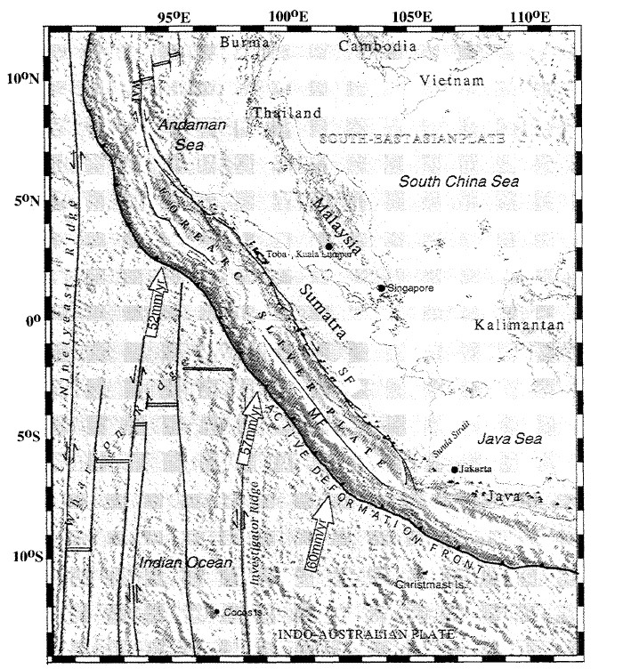
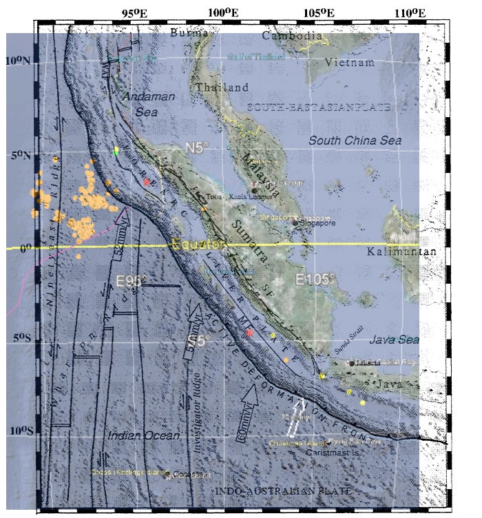
If I selected the two pics properly . . . They both seem to show somewhat the sort of thing I'm sort of getting at in terms of the movements of the plate North, toward the DEFORMATION boundary layer West of the island of Sumatra. There appears to be a bunching up there. I think, as the Southern plate dives under the Northern plate.
What I'm wondering and conjecturing about is
COULDN'T we--wouldn't it be possible to identify such trending deformations by looking carefully at earlier details before such trends became so largely and brazenly obvious?
Such as further out maybe from the island of Sumatra . . . or perhaps in the ocean off Christchurch or on the plain between the volcanic cone jutting out from Christchurch and the mountain behind Christchurch . . .
or in the ocean off Oregon where I don't see any BRAZENLY OBVIOUS such trends yet . . . but I'd think there MIGHT be some clues accessible to careful examination.
reply to post by TrueAmerican
To calculate stress redistribution, this is one of our standard tools that is fairly user friendly:
earthquake.usgs.gov...
As far as TA's stress redistribution question - we tend to think of the Coulomb stress (and strain) as energy available to drive earthquakes. It is the shear stress, minus some fraction (to account for friction, often 20-60%) of the normal stress, which depends on the choice of plane on which to resolve it. Sorry, it's a dot product of a vector and a tensor. Figuring out what will happen depends on some factors we only very poorly know - level of absolute stress, the critical stress required to break the faults, and the orientation of planes of weakness.
So our evaluations of what has and especially what will happen depends on making a lot of guesses.
reply to post by BO XIAN
It's dubious to use that paper to discuss tectonics. Those are not the active faults. The Ninety-East Ridge is NOT a fault, for example.
Here's a cartoon to start with, check out Figure 9
www.sciencedirect.com...
Better still, Figure 1 in this one
www.sciencedirect.com...
It's dubious to use that paper to discuss tectonics. Those are not the active faults. The Ninety-East Ridge is NOT a fault, for example.
Here's a cartoon to start with, check out Figure 9
www.sciencedirect.com...
Better still, Figure 1 in this one
www.sciencedirect.com...
quake watch is over,,,,
why you ask?
what do the following have in common,,,
1.
14.04.2012 22:11 PM Vanuatu Islands 6.6
2.
11.04.2012 13:18 PM Coast Of Northern Sumatra 8.7
3.
15.01.2012 13:50 PM South Shetland Islands 6.7
Thats right,,, there all known for Volcananic,,,
outbursts.
And i haven't even mentioned,,half dozen others,,
So the correct answer is,,
15.01.2012,,,
11.04.2012
14.04.2012
8.7 Sumatra,,,The Great Sumatran fault,
a strike-slip fault*,
runs the entire length of the island along its west coast.
Vanuatu Islands 6.6
Ambrym is a large basaltic volcano with a 12-km-wide caldera, and one of the most active volcanoes of the New Hebrides volcanic arc.
South Shetland Islands 6.7
is the remnants of a much larger volcanic edifice that is now largely submerged.
quake watch,,naw,,we need everyone of u at,,
Volcano Watchers Thread,,,
11.04.2012
14.04.2012,,tick tock,,,
*intersesting
Me.
and also,,
16.04.2012 02:15:41 2.2 North America Canada British Columbia
Princeton
P.s,,,disregard rant below,,,ADULT,,oriented,,,
SOMEBOBY TELL THE COPPER MINE UP THERE TOO
REDUCE
there EXPLOSIVES TNT/MW/MJ/MB,
sizes,,,
ok,, sorry for shouting,,,but these
PRINCETON B.C ,,assholes
quake listing's on the
RSOE EDIS,,
quake list,,are REALLY starting too ANOY me,
,they seem too be hapening
a bit latetly,more and more,,, and im assuming its
the Copper Mine,,its
pretty big,
mine,,copper,gold,,silver,,
enough with the quakes ,,ok.
A concerned CANADIAN.
Me.
edit on 15-4-2012 by BobAthome because: (no reason given)
reply to post by JohnVidale
Thanks for your thoughtful links.
Alas, I spent far too much of my income in behalf of my students when overseas. I don't have sufficient funds to spend on such articles and I couldn't figure out how to access the graphics without paying for access. Maybe I'm too tired or too ignorant.
If you have a link that looks at the graphics for free, great.
Could you summarize what you see the graphic showing relative to my conjectures and questions, please?
reply to post by BO XIAN
I think if you google plate tectonics and indian plate and australian plate, you'll see the information. Basically, the recent earthquake probably broke as part of the indian-australian plate boundary deformation, and the boundary is mainly east-west, not north-south.
The Wikipedia article is a place to start:
en.wikipedia.org...
2.2 2012/04/15 05:00:53 35.363 -92.090 0.1 4 km ( 2 mi) NNW of Rose Bud, AR
2.2 2012/04/15 04:45:01 35.359 -92.091 2.3 3 km ( 2 mi) NNW of Rose Bud, AR
2.0 2012/04/12 21:12:29 35.374 -92.099 0.1 5 km ( 3 mi) NNW of Rose Bud, AR
2.0 2012/04/12 06:53:11 35.382 -92.109 0.1 6 km ( 4 mi) NNW of Rose Bud, AR
1.9 2012/04/12 05:33:59 35.373 -92.093 0.1 5 km ( 3 mi) NNW of Rose Bud, AR
2.0 2012/04/12 04:09:29 35.379 -92.121 0.1 6 km ( 4 mi) NW of Rose Bud, AR
With all the big action we can't forget the wee ones. It's not a full fledge swarm, but it's sumtin'. The ridiculous part is there are fracking pads everywhere. It's not far from Quitman which has also been very active in the past.
...Rosebud...
so is it normal for "crazy earthquakes" a couple days ago and now we have complete silence? idk..
reply to post by Jordan River
Pretty much so...
Until maybe the next planetary alignments in mid-May, if you believe that sort of stuff
Pretty much so...
Until maybe the next planetary alignments in mid-May, if you believe that sort of stuff
reply to post by JohnVidale
THANKS THANKS.
Interesting maps and narrative at your wiki link.
I find myself wondering how much of that stuff is conjecture.
The maps look so definitive yet mysterious, puzzling.
At least to this layman, they seem to have plenty of aspects which are . . . odd . . . not immediately self-evident as to why they are the way they supposedly are.
But maybe I'm the only one who looks at them that way.
Maybe I should take my crazy hypotheses and speculations and go home. LOL.
Bit of a rattler on land, but looks like it's a fairly remote area.
Source
This event has been reviewed by a seismologist.
Magnitude 5.8
Date-Time
Monday, April 16, 2012 at 02:17:49 UTC
Monday, April 16, 2012 at 10:17:49 AM at epicenter
Time of Earthquake in other Time Zones
Location 2.608°S, 121.831°E
Depth 9.9 km (6.2 miles)
Region SULAWESI, INDONESIA
Distances 169 km (105 miles) NNW of Kendari, Sulawesi, Indonesia
186 km (115 miles) ENE of Palopo, Sulawesi, Indonesia
1474 km (915 miles) NW of DARWIN, Northern Territory, Australia
1711 km (1063 miles) ENE of JAKARTA, Java, Indonesia
Location Uncertainty horizontal +/- 13.6 km (8.5 miles); depth +/- 4.2 km (2.6 miles)
Parameters NST=133, Nph=134, Dmin=202.6 km, Rmss=1.31 sec, Gp= 43°,
M-type=regional moment magnitude (Mw), Version=9
Source
Magnitude: USGS NEIC (WDCS-D)
Location: USGS NEIC (WDCS-D)
Event ID usc00094j4
Source
reply to post by BobAthome
Bob, although I am no professional, I totally agree with you.
I was coming on here this morning to ask/say, that some have been asking why south America has been relatively eq free during the recent flurry. They seem to have affected all down the western seabord side from Alaska down to Mexico/Gulf......and then nada, zip, dim. I was going to ask the question is it not because South America is experiencing its own kind of 'pressure release' with quite a few major volcanoes venting right now?
I am no longer asking the question, I am going with my gut instinct, which I have said here a few times...there is more to these eq's around Indonesia, especially the 'double whammie'.....it's the magma we should be looking at, its way down and on its way up...Indo/Philipine will give/start the next super major event which will effect us worldwide.
There are times in our history, where what we accepted to be fact, measurable evidence, where something comes from left field to send us back to the drawing board and re-work the math. The Indo/Sumatra 'double whammie' was a heads up.
Rainbows
Jane
Interesting little statistic that I just stumbled across tonight...
Between 1868 and 2003 there has been at least ONE death in the US caused by an earthquake, every 1 to 9 years.
Unfortunately the last recoded death was in 2003 making 2012 a strong statistical possibility for there being another killer quake to strike somewhere in the US this year
Interesting enough, the years between 1987 and 1995 had earthquake related deaths on an almost YEARLY basis, then a gap of 8 years till the last deaths at the end of 2003 from a Central Californian quake.
There were only two non-death quake related years were 1988 and 1990 though in 1987 there were 2 deaths in the same year from 2 quakes just days apart.
Unfortunately the majority of all those quakes originated in California.
Source
edit on 16-4-2012 by SpaceJockey1 because: formatting
Magnitude ML 4.7
Region WESTERN TURKEY
Date time 2012-04-16 10:10:46.0 UTC
Location 39.14 N ; 29.14 E
Depth 5 km
Distances 118 km S Bursa (pop 1,412,701 ; local time 13:10:46.2 2012-04-16)
56 km NW Usak (pop 152,862 ; local time 13:10:46.2 2012-04-16)
15 km E Simav (pop 34,909 ; local time 13:10:46.2 2012-04-16)
14 km NW Saphane (pop 5,085 ; local time 13:10:46.2 2012-04-16)
Source parameters provided by another agency
EMSC
Rainbows
Jane
reply to post by JohnVidale
The paper I referenced has markers showing ninety-east ridge to be a (movement) boundary as it has the little marker arrows on it.
What is effect you are saying is that we have always known, which is that you don't know whom to trust in the scientific world because they are singing from different hymn sheets and different agendas! Nothing new there then.
With regard to the links John may I respectfully point out that the documentation is behind a pay-wall and many of us, myself included, do not have the pecuniary wherewithall to purchase the many documents we come across.
::begin rant
Personally I think it is an absolute disgrace that people should be expected to pay for this type of information, much of which has already had input from the taxpayer. These 'publishing journals' are simply a money grabbing elitist scam and they should be closed immediately.
The day education moved from a provision of the State to a paid privilege and an elitist club was a sad one for the whole world.
Education, and the means to learn, should be open and free to everyone. Capitalism has NO place in education. These journals disgust me.
::end rant
edit on 16/4/2012 by PuterMan because: (no reason given)
reply to post by PuterMan
I thoroughly agree with your rant.
In the case of the quake information, much of it could be construed as life/death issues type information.
And the public trough aspect of elitist education already being hugely contributed to by the slaves is just teeth grinding outrageous.
The information ought to be liberally spread abroad--particularly to taxpayers. Sheesh.
GRRR.
Thanks for saying what was overdue.
If anyone comes across similar information that's available free on the net, please let me know.
Maybe I'm too dogged on my speculations . . . maybe I'm a blathering idiot about terrain folding, alterations that can be inferred from looking at the surface terrain like a thick piece of cloth.
Perhaps there's a slight chance I'm not a blathering idiot. I'd love to have some willing to look at the issues more closely with me BASED ON some better information from science etc.
I realize that most all RELIGION OF SCIENTISM accolytes are NOT used to thinking outside the box . . . that ORTHODOXY is rewarded and out-side-the-box is punished in the halls and journals of elitist "science."
However, I doggedly think there are enough folks who enjoy thinking outside the box . . . that in an area so critical to lives . . . there might be a few who'd be willing to join me on the quake speculation, extrapolation stuff just as a thought-experiment, if nothing else.
I do realize that trying to make even meager inferences about quake generated terrain alterations is likely to be frought with failure and error.
However, CERTAINLY NOT MAKING THE EFFORT would be an utter failure.
I KNOW I'm an ignorant shrink in this field. That does not EQUATE to an absolute idiot totally . . . regardless of what some may believe hereon. LOL.
I just happen to believe that brainstorming collaboratively on the topic MIGHT be fruitful and is worth the bother.
RSOE Alert Map
Just noticed Oklahoma had a 3.9 earthquake on the Wilzetta Fault Line. It was 5km deep. Not very large, but I know we haven't had many on that fault line. The ones we have had were more southeast of OKC.
Just noticed Oklahoma had a 3.9 earthquake on the Wilzetta Fault Line. It was 5km deep. Not very large, but I know we haven't had many on that fault line. The ones we have had were more southeast of OKC.
reply to post by PuterMan
Paying journals for information. Me thinks you are a little too conservative to complain too much.
(gentle ribbing)
If it were up to me I'd hack the world and make all knowledge freeeee. I am giving all my secrets away. But- 'cause I have nothing, it may end up costing you in the end. I may be wasting your time. And time is money.
Your complaint is valid, but it is not the most absurd example of tax dollar sponsored studies, and the obstacles encountered when trying to gain access to the information.
This applies to the United States.
If a principal wants to know about the lead content of the paint in the school's walls, they need to pay a fee to get a copy of the law and the standards. In another case, a congressman wanted to find out information on a certain law and found out he'd have to pay 1500 dollars for the publication.
The laws are not made for we mere mortals. They made by, and for, businesses and the lawyers. We with megear means can hardly invest the time and money it takes to know and understand all the codes. That's why we have professionals. The businesses. And these businesses, when all grown up we call them corporations, these private companies take our tax dollars and develop the codes. If things change, or they don't like the codes the government and/or demands and adopts, they create lobbies and change the codes again suit them. The lawyers manufacture contracts that are thousands of pages long so no human with average reading skills could ever hope to read the whole thing. Information and knowledge are not free. On the radio the other day, I heard a fella describing his student loans. He was almost ready to be a doctor. His debt when he takes his takes patient:
500 000
Information is power.
Privacy keeps the power. Fracking companies want to keep their sandy-oily-water recipe secret. Cause it gives them an advantage over the other guy. ???? Remember they are privateers. Pirates. Each energy company is a pirate ship. Kinda like - this short film will explain it better than I ever could.
www.youtube.com...
Oklahoma. Where the...
Tornadoes, earthquakes, racist crazed killers, drought, etc. This place knows misery. I just remembered 1995.
Where did the "Trail of Tears" finish?
Oklahoma.
Oklahoma 3.9M
edit on 16-4-2012 by ericblair4891 because: (no reason given)
new topics
-
President BIDEN's FBI Raided Donald Trump's Florida Home for OBAMA-NORTH KOREA Documents.
Political Conspiracies: 4 hours ago -
Maestro Benedetto
Literature: 5 hours ago -
Is AI Better Than the Hollywood Elite?
Movies: 6 hours ago -
Las Vegas UFO Spotting Teen Traumatized by Demon Creature in Backyard
Aliens and UFOs: 9 hours ago -
2024 Pigeon Forge Rod Run - On the Strip (Video made for you)
Automotive Discussion: 10 hours ago -
Gaza Terrorists Attack US Humanitarian Pier During Construction
Middle East Issues: 10 hours ago -
The functionality of boldening and italics is clunky and no post char limit warning?
ATS Freshman's Forum: 11 hours ago
top topics
-
President BIDEN's FBI Raided Donald Trump's Florida Home for OBAMA-NORTH KOREA Documents.
Political Conspiracies: 4 hours ago, 25 flags -
Krystalnacht on today's most elite Universities?
Social Issues and Civil Unrest: 15 hours ago, 9 flags -
Supreme Court Oral Arguments 4.25.2024 - Are PRESIDENTS IMMUNE From Later Being Prosecuted.
Above Politics: 15 hours ago, 8 flags -
Weinstein's conviction overturned
Mainstream News: 13 hours ago, 8 flags -
Massachusetts Drag Queen Leads Young Kids in Free Palestine Chant
Social Issues and Civil Unrest: 12 hours ago, 7 flags -
Gaza Terrorists Attack US Humanitarian Pier During Construction
Middle East Issues: 10 hours ago, 7 flags -
Las Vegas UFO Spotting Teen Traumatized by Demon Creature in Backyard
Aliens and UFOs: 9 hours ago, 6 flags -
Meadows, Giuliani Among 11 Indicted in Arizona in Latest 2020 Election Subversion Case
Mainstream News: 12 hours ago, 5 flags -
2024 Pigeon Forge Rod Run - On the Strip (Video made for you)
Automotive Discussion: 10 hours ago, 4 flags -
Is AI Better Than the Hollywood Elite?
Movies: 6 hours ago, 3 flags
active topics
-
Supreme Court Oral Arguments 4.25.2024 - Are PRESIDENTS IMMUNE From Later Being Prosecuted.
Above Politics • 88 • : Irishhaf -
SHORT STORY WRITERS CONTEST -- April 2024 -- TIME -- TIME2024
Short Stories • 23 • : DontTreadOnMe -
President BIDEN's FBI Raided Donald Trump's Florida Home for OBAMA-NORTH KOREA Documents.
Political Conspiracies • 16 • : Astyanax -
Truth Social goes public, be careful not to lose your money
Mainstream News • 130 • : Astyanax -
Las Vegas UFO Spotting Teen Traumatized by Demon Creature in Backyard
Aliens and UFOs • 11 • : AwakeNotWoke -
Is AI Better Than the Hollywood Elite?
Movies • 13 • : Justoneman -
Hate makes for strange bedfellows
US Political Madness • 47 • : 19Bones79 -
-@TH3WH17ERABB17- -Q- ---TIME TO SHOW THE WORLD--- -Part- --44--
Dissecting Disinformation • 689 • : daskakik -
University of Texas Instantly Shuts Down Anti Israel Protests
Education and Media • 265 • : Astrocometus -
Gaza Terrorists Attack US Humanitarian Pier During Construction
Middle East Issues • 27 • : ToneD