It looks like you're using an Ad Blocker.
Please white-list or disable AboveTopSecret.com in your ad-blocking tool.
Thank you.
Some features of ATS will be disabled while you continue to use an ad-blocker.

Quake Watch 2012
page: 107share:
reply to post by PuterMan
Now there's a network you don't see mentioned everyday!
Good. I think that trace pretty much sums it up.
Edit: And yup the spectro of that seals the deal. Just look at the separate high end propagation. That MUST be a second event, because that high end could not physically be there from the first quake due to attenuation over distance.
Sorry John, but you've been ATS'd. You love us though, admit it.
edit on Sat Apr 14th 2012 by TrueAmerican because: (no reason
given)
reply to post by TrueAmerican
So does this mean I can put the dunces cap back on the shelf?
BTW in case you missed the waveform (I tend to edit existing boxes)
So does this mean I can put the dunces cap back on the shelf?
BTW in case you missed the waveform (I tend to edit existing boxes)
edit on 14/4/2012 by PuterMan because: To add a question mark. They give so much more meaning and help to convey the fact that you are asking
a question rather than making a statement. I really should try and use them more often.
reply to post by PuterMan
Forget the dunce cap Puter, we all screw up from time to time. The great thing is, we have each other to help reach consensus. That is the most important thing.
But John just asked a question, remember, he did not come right out and say, or insist, it was one quake. I am sure that they will determine that on their own now.
edit on Sat Apr 14th 2012 by TrueAmerican because: (no reason given)
Originally posted by BobAthome
the only thing that makes sence is that the constant vibration,,from here,,
Friday, 13th April 2012 at 05:31 AM
Local Date/Time: Friday, April 13, 2012 at 11:31 in the moorning at epicenter
Coordinate: 2° 45.456, 89° 35.544
is taking on a "sling shot" effect from the
Antarctic "horse-show"
and Eurica!
Giant Impact Wave,,, out of no where?? impossible!
rebound sling-shot from the Antarctic,, horseshoe,, bammmm,, Gianna,,
its called billiards...,,lol
Me.
ohhh he replied too himself,,,,,,,,,,,,,,,
"ocean floor of the Drake Passage between South America and Antarctica"
ya this area,,,
ohh wait a 6.1 you say ,,hmmm
gee guess everyone seen that comming,,
just like mr. invisible Rouge Wave.
But then again
from all of the replies that i got ,, well,,,
i'll just keep mumbling away,,,,
ya,
Me.
edit on 14-4-2012 by BobAthome because: (no reason given)
reply to post by BobAthome
Bob, you crack me up for sure.
You are in a thread about quakes, talking about some invisible wave that supposedly hit some ship, slinging it into another ship. I checked into that, and all I saw was a report that two ships collided. Where in the world do you come up with this stuff?
Oh. GLP. Yup, should have known.
reply to post by BobAthome
I'm guessing this is directed at me as I am the only one who responded to your initial post.
You may note that my comment was posed as a question as indicated by the "?" at the end of my first line.
It was not a categorical pronouncement that that was the only possible answer. I figured that if there were anything of merit to investigate, some of the more experienced posters would do so. TA looked into it as indicated by his post above and found nothing of interest.
Perhaps you could provide a link with more information?
just like mr. invisible Rouge Wave.
I'm guessing this is directed at me as I am the only one who responded to your initial post.
You may note that my comment was posed as a question as indicated by the "?" at the end of my first line.
It was not a categorical pronouncement that that was the only possible answer. I figured that if there were anything of merit to investigate, some of the more experienced posters would do so. TA looked into it as indicated by his post above and found nothing of interest.
Perhaps you could provide a link with more information?
reply to post by jadedANDcynical
quote
"the only thing that makes sence is that the constant vibration,,from here,,"
unquote
is having a direct,,in-line effect,,
with here,,
quote
"Antarctic "horse-show" "
which the poster so stupidly called,,
(its the drake passage u idiot!)
and Eurica!
Giant Impact Wave
Drake Pasage,,Antarctic,"horse-show" ",
so im glad that the
quote
"Giant Impact Wave,,, out of no where?? impossible!"
unquote
was just that according too everyone here,,
completely irrelevent,,
looking at the timing of the events,,one can clearly see NO CAUSAE EFFECTUS,, here,,
so i humbly submit too my more learned ,
whatevers,
Me.
quote
"the only thing that makes sence is that the constant vibration,,from here,,"
unquote
is having a direct,,in-line effect,,
with here,,
quote
"Antarctic "horse-show" "
which the poster so stupidly called,,
(its the drake passage u idiot!)
and Eurica!
Giant Impact Wave
Drake Pasage,,Antarctic,"horse-show" ",
so im glad that the
quote
"Giant Impact Wave,,, out of no where?? impossible!"
unquote
was just that according too everyone here,,
completely irrelevent,,
looking at the timing of the events,,one can clearly see NO CAUSAE EFFECTUS,, here,,
so i humbly submit too my more learned ,
whatevers,
Me.
Magnitude Mw 6.0
Region KURIL ISLANDS
Date time 2012-04-14 15:13:11.0 UTC
Location 49.41 N ; 155.69 E
Depth 60 km
Distances 1307 km NE Sapporo (pop 1,883,027 ; local time 00:13:11.3 2012-04-15)
451 km SW Petropavlovsk-kamchatskiy (pop 187,282 ; local time 04:13:11.3 2012-04-15)
455 km SW Mokhovaya, petropavlovsk-kamch (pop 22,815 ; local time 04:13:11.3 2012-04-15)
Source parameters not yet reviewed by a seismologist
EMSC
Rainbows
Jane
reply to post by TrueAmerican
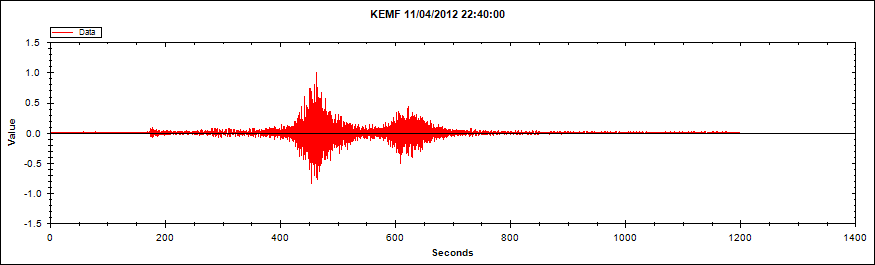
Those are the P and S waves. I just pulled up the seismograms across the network, and I can see the time separation systematically increasing with distance with the trend expected from their respective velocities. That change would not happen if they were P waves from two distinct events, in which case the time separation would stay the same.
Those are the P and S waves. I just pulled up the seismograms across the network, and I can see the time separation systematically increasing with distance with the trend expected from their respective velocities. That change would not happen if they were P waves from two distinct events, in which case the time separation would stay the same.
reply to post by JohnVidale
You are aware that PM converted this to audio and we hear two distinct and separate booms, right? And if what you are saying is true, then why don't we hear two separate and distinct booms for every other earthquake then? It is always just one boom, and is followed by rumble usually for bigger events. Smaller events just boom and die out quick.
Also, if that's the case, then why was it determined last time that it was two separate events? Shall I write back to Global CMT and tell them that the PNSN director was mistaken?
lol, funny. We get nearly identical signatures in nearly the same location, along the same divergent boundary, caused most probably by the same mechanism, and yet now all of sudden it's one quake instead of two?
No, no and no. Sorry John, I am sticking with two events here. I have provided every reason it is two events, and you have not refuted my specific points about them. That high end just doesn't appear out of nowhere again, for the same quake. Or the low end either.
reply to post by TrueAmerican
I guess we can agree to disagree.
I am surprised that you'd interpret waves traveling at the expected time and expected velocity of the S waves from a known earthquake to instead be P waves from a whole separate magnitude 5 earthquake that no one had spotted.
I guess we can agree to disagree.
I am surprised that you'd interpret waves traveling at the expected time and expected velocity of the S waves from a known earthquake to instead be P waves from a whole separate magnitude 5 earthquake that no one had spotted.
reply to post by JohnVidale
Oops, magnitude 6 event. I did look at the records of several dozen different stations before deciding my opinion, both horizontal and vertical records.
Oops, magnitude 6 event. I did look at the records of several dozen different stations before deciding my opinion, both horizontal and vertical records.
reply to post by JohnVidale
Yeah, it's not like any major ordeal if we do disagree. So what.
But could you please explain then the points I have raised about this event in the preceeding posts about this. Did you listen to the audio file?
Yeah, it's not like any major ordeal if we do disagree. So what.
But could you please explain then the points I have raised about this event in the preceeding posts about this. Did you listen to the audio file?
reply to post by TrueAmerican
I'm being pressured to go have breakfast, and didn't look carefully at all the spectrograms and audio files. But I think the point on which we're disagreeing is whether sharp onsets and similar frequency content can characterize both P and S waves. S waves can have relatively sharp onsets, and the spectra did show that the second burst was a bit lower in frequency content than the first, as expected for S vs P waves.
I'm being pressured to go have breakfast, and didn't look carefully at all the spectrograms and audio files. But I think the point on which we're disagreeing is whether sharp onsets and similar frequency content can characterize both P and S waves. S waves can have relatively sharp onsets, and the spectra did show that the second burst was a bit lower in frequency content than the first, as expected for S vs P waves.
reply to post by JohnVidale
Ok. I of course take seriously into consideration what you have to say. I will revisit it myself, and pull the data. I have to go too now. Let's hook up again later maybe. Have a good breakfast! TTYS.
Ok. I of course take seriously into consideration what you have to say. I will revisit it myself, and pull the data. I have to go too now. Let's hook up again later maybe. Have a good breakfast! TTYS.
reply to post by TrueAmerican
A last suggestion before brunch - pull out some stations close and far from the epicenter and compare the time difference between the 2 bursts of energy.
A last suggestion before brunch - pull out some stations close and far from the epicenter and compare the time difference between the 2 bursts of energy.
reply to post by angelchemuel
May be a bit high, GFZ has 5.9 on the main list but 5.5 on the link page (must just have revised it) and USGS 5.6
hard to tell from my local LISS station graph, when you compare it with the Drake Passage 6.2 it doesn't look near as big as a 6.0 SNZO Graph
Nice clean wiggle for DP though, you can see the P, S and LR waves arriving quite clearly, not so easily for Kuril
SNZO - Drake Passage =7,684 km
SNZO- Kuril Islands =10,250 km
2566km difference
reply to post by PuterMan
I wouldn't have even picked it for a 5.9, the depth gets me every time on first glance of the graph
SNZO 10-02-2012
I note looking at your copy of the phase data that there is a 4 second difference for the S wave from what I used on the SNZO
USGS Phase Data = 01:55:38
USGS Arrival Time Calculator = 01:55:42
I don't usually bother checking the phase data on USGS for SNZO as doesn't always show on the list, URZ shows more often.
4 seconds = life or death?
just sayin, accuracy and consistency isn't one of USGS's strong points
I wouldn't have even picked it for a 5.9, the depth gets me every time on first glance of the graph
SNZO 10-02-2012
edit on 14-4-2012 by muzzy because: (no reason given)
I note looking at your copy of the phase data that there is a 4 second difference for the S wave from what I used on the SNZO
USGS Phase Data = 01:55:38
USGS Arrival Time Calculator = 01:55:42
I don't usually bother checking the phase data on USGS for SNZO as doesn't always show on the list, URZ shows more often.
4 seconds = life or death?
edit on 14-4-2012 by muzzy because: (no reason given)
just sayin, accuracy and consistency isn't one of USGS's strong points
edit on 14-4-2012 by muzzy because: (no reason given)
Another 6
might as well have stayed logged in
www.bmkg.go.id...
USGS 5.9mb surely on conversion to Mw it should go UP
EMSC 5.8mb
GFZ 5.8Mw
RAS gone to bed
GeoAu haven't got up yet
might as well have stayed logged in
6.0ML
15-Apr-12 02:26:39 WIB
7.17 S - 105.13 E
10 Km
does not generate TSUNAMI
Epicenter located in
95 km SouthWest PANDEGLANG-BANTEN ,
134 km SouthWest LEBAK-BANTEN ,
162 km SouthWest CILEGON-BANTEN ,
164 km SouthWest SERANG-BANTEN ,
216 km SouthWest JAKARTA-INDONESIA
Felt (MMI): II - III Jakarta,
www.bmkg.go.id...
USGS 5.9mb surely on conversion to Mw it should go UP
EMSC 5.8mb
GFZ 5.8Mw
RAS gone to bed
GeoAu haven't got up yet
edit on 14-4-2012 by muzzy because: (no reason given)
Magnitude 6.6 Vanuatu
Location in Google Maps
- Date-Time: Saturday, April 14, 2012 at 22:05:28 UTC
Sunday, April 15, 2012 at 09:05:28 AM at epicenter
- Location: 19.055°S, 168.794°E
- Depth: 33 km (20.5 miles) set by location program
- Region: VANUATU
- Distances:
73 km [45 miles] NW [317°] from Isangel, Vanuatu
154 km [96 miles] SSE [160°] from PORT-VILA, Vanuatu
290 km [180 miles] NNE [19°] from Tadine, Loyalty Islands, New Caledonia
1864 km [1158 miles] ENE [63°] from Brisbane, Australia
- Location Uncertainty: Error estimate not available
- Parameters: NST= 13, Nph= 13, Dmin=250.4 km, Rmss=1.4 sec, Gp= 68°,M-type="moment" magnitude from initial P wave (tsuboi method)
(Mi/Mwp), Version=1
- Source: West Coast and Alaska Tsunami Warning Center/NOAA/NWS
- Event ID: at00m2hpd4
Derived from Data Source: USGS
Powered by QVSData
new topics
-
President BIDEN's FBI Raided Donald Trump's Florida Home for OBAMA-NORTH KOREA Documents.
Political Conspiracies: 11 minutes ago -
Maestro Benedetto
Literature: 1 hours ago -
Is AI Better Than the Hollywood Elite?
Movies: 1 hours ago -
Las Vegas UFO Spotting Teen Traumatized by Demon Creature in Backyard
Aliens and UFOs: 5 hours ago -
2024 Pigeon Forge Rod Run - On the Strip (Video made for you)
Automotive Discussion: 6 hours ago -
Gaza Terrorists Attack US Humanitarian Pier During Construction
Middle East Issues: 6 hours ago -
The functionality of boldening and italics is clunky and no post char limit warning?
ATS Freshman's Forum: 7 hours ago -
Meadows, Giuliani Among 11 Indicted in Arizona in Latest 2020 Election Subversion Case
Mainstream News: 8 hours ago -
Massachusetts Drag Queen Leads Young Kids in Free Palestine Chant
Social Issues and Civil Unrest: 8 hours ago -
Weinstein's conviction overturned
Mainstream News: 9 hours ago
top topics
-
Krystalnacht on today's most elite Universities?
Social Issues and Civil Unrest: 11 hours ago, 9 flags -
Supreme Court Oral Arguments 4.25.2024 - Are PRESIDENTS IMMUNE From Later Being Prosecuted.
Above Politics: 11 hours ago, 8 flags -
University of Texas Instantly Shuts Down Anti Israel Protests
Education and Media: 14 hours ago, 7 flags -
Weinstein's conviction overturned
Mainstream News: 9 hours ago, 7 flags -
Gaza Terrorists Attack US Humanitarian Pier During Construction
Middle East Issues: 6 hours ago, 7 flags -
Massachusetts Drag Queen Leads Young Kids in Free Palestine Chant
Social Issues and Civil Unrest: 8 hours ago, 6 flags -
Meadows, Giuliani Among 11 Indicted in Arizona in Latest 2020 Election Subversion Case
Mainstream News: 8 hours ago, 5 flags -
Las Vegas UFO Spotting Teen Traumatized by Demon Creature in Backyard
Aliens and UFOs: 5 hours ago, 4 flags -
President BIDEN's FBI Raided Donald Trump's Florida Home for OBAMA-NORTH KOREA Documents.
Political Conspiracies: 11 minutes ago, 3 flags -
2024 Pigeon Forge Rod Run - On the Strip (Video made for you)
Automotive Discussion: 6 hours ago, 2 flags
active topics
-
Meadows, Giuliani Among 11 Indicted in Arizona in Latest 2020 Election Subversion Case
Mainstream News • 14 • : WeMustCare -
HORRIBLE !! Russian Soldier Drinking Own Urine To Survive In Battle
World War Three • 44 • : theshadowknows -
University of Texas Instantly Shuts Down Anti Israel Protests
Education and Media • 233 • : DBCowboy -
President BIDEN's FBI Raided Donald Trump's Florida Home for OBAMA-NORTH KOREA Documents.
Political Conspiracies • 0 • : WeMustCare -
God's Righteousness is Greater than Our Wrath
Religion, Faith, And Theology • 31 • : glend -
Post A Funny (T&C Friendly) Pic Part IV: The LOL awakens!
General Chit Chat • 7135 • : underpass61 -
Nearly 70% Of Americans Want Talks To End War In Ukraine
Political Issues • 94 • : Scratchpost -
VP's Secret Service agent brawls with other agents at Andrews
Mainstream News • 62 • : ByeByeAmericanPie -
SETI chief says US has no evidence for alien technology. 'And we never have'
Aliens and UFOs • 72 • : yuppa -
My Poor Avocado Plant.
General Chit Chat • 77 • : JonnyC555