It looks like you're using an Ad Blocker.
Please white-list or disable AboveTopSecret.com in your ad-blocking tool.
Thank you.
Some features of ATS will be disabled while you continue to use an ad-blocker.

Quake Watch 2012
page: 104share:
Better grab your bargain earthquakes while you can.
Oregon will be a 6.0, or possibly a 6.1 eventually some time 8 days in the future.
The Gulf of California will be a 7.0 but probably not until it hits ANSS
The two Indonesian Mag 8 quakes remain anomalous.
Oregon will be a 6.0, or possibly a 6.1 eventually some time 8 days in the future.
The Gulf of California will be a 7.0 but probably not until it hits ANSS
The two Indonesian Mag 8 quakes remain anomalous.
Originally posted by PuterMan
Better grab your bargain earthquakes while you can.
Oregon will be a 6.0, or possibly a 6.1 eventually some time 8 days in the future.
The Gulf of California will be a 7.0 but probably not until it hits ANSS
The two Indonesian Mag 8 quakes remain anomalous.
wtf kind of source is this?
--- P -----
------- ---------
----------------------#
##--------------------#####
#####-----------------#######
########-------------##########
##########----------###########
#############------##############
##############--###############
T ##############--###############
############------#############
############---------##########
##########-------------########
########----------------#####
#####--------------------##
#----------------------
-------------------
-----------
reply to post by Bluesma
For bumch of eggheads that is a long way off, and note that it is good until June.
No I guess the facilities were not in place early enough for Indonesia.
We shall watch and see as time progresses. I hope they do have it right but......................now they have stuck their necks out they can expect to getthem chopped off their findings closely scrutinised.
That warning was issued April 9th. Perhaps they just got their location a bit off ...????
For bumch of eggheads that is a long way off, and note that it is good until June.
No I guess the facilities were not in place early enough for Indonesia.
We shall watch and see as time progresses. I hope they do have it right but......................now they have stuck their necks out they can expect to get
reply to post by PuterMan
Robinesque Ruminations is Magic in my humble opinion because hide love and feelings...in my humble opinion.Love for people like a hundred years ago..ago...Titanic....
Anything of a speculative nature to do with Yellowstone / Fracking / Arkansas / Bird Deaths / Hudson Bay / Life / Death / Resurrection / the Economy / Politics / Religion etc you can post on the thread hosted by Robin Marks/Eric Blair: Robinesque Ruminations
reply to post by Jordan River
Ha ha, now you know why I did not post them! They don't work as text as the formatting gets stripped.
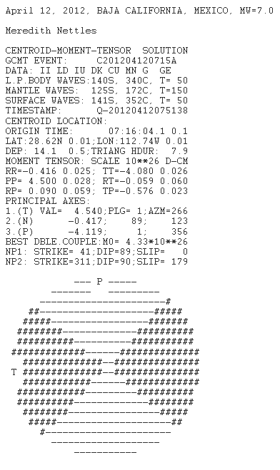
Source
Masses more on that site about the 'beach ball' as well as a video of what the quadrants represent.
Forgot to say move slightly up from that link point and there are more AVIs of the beach ball.
Ha ha, now you know why I did not post them! They don't work as text as the formatting gets stripped.
Focal Mechanisms (aka Beach Balls)
A focal mechanism is a fancy way of saying which way the fault moved during an earthquake and is often derived automatically by computer based analysis of seismograms. A "beach ball" symbol is used to visualize this movement. The beach ball is a sphere cut into quarters and shaded with alternating colors, usually white and some other color. In our example we use white and red.
The two "slices" through the beach ball represent the two possible orientations of the plane of the fault. The computers look at the waveforms from as many seismographs as possible and by looking at the direction the ground first starts to move at each location, they can compute which way the fault moved. Unfortunately, there's always two possible solutions, each orthogonal to each other. However, it's pretty easy to determine which fault plane is the correct one by comparing the computed solutions with the orientation of known faults. One of the computed solutions usually lines up very closely to the direction of the fault which produced the earthquake.
The other feature of a beach ball are the colored quadrants. These quadrants represent the stress field around the hypocenter, with the tension axis (where strain is reduced) represented by the white quadrants, and the pressure axis (where strain increases) represented by the red quadrants. A simpler way to look at it is that it represents the direction of motion, that being from white to red.
Sometimes the beach ball is difficult to understand due to it's orientation. Sometimes it's just a flat line drawing. Just remember, the image you are looking at is supposed to be a 3 dimensional sphere.
Source
Masses more on that site about the 'beach ball' as well as a video of what the quadrants represent.
Forgot to say move slightly up from that link point and there are more AVIs of the beach ball.
edit on 12/4/2012 by PuterMan because: (no reason given)
reply to post by Pharyax
If you look in the upper right hand corner of the map, there is a "save settings" button which will bring up a pop up (allow them for the site if you have a blocker) which will set you a cookie. It will save the settings and even the particular map view that is in the window when you set the cookie.
I wish it would cookie the settings I chose on the left.
If you look in the upper right hand corner of the map, there is a "save settings" button which will bring up a pop up (allow them for the site if you have a blocker) which will set you a cookie. It will save the settings and even the particular map view that is in the window when you set the cookie.
This news is from INDIA. Just thought it needed to be in 'QUAKEWATCH'.
Here goes the link:
news.in.msn.com...
This can be checked in the next 3 months.
Here goes the link:
news.in.msn.com...
This can be checked in the next 3 months.
There was a 4.5 off the coast of Massachusetts this morning. Surprised there isn't a doom and gloom thread about it already. LOL. 4.5 isn't all
that big, and this was far off the coast of Mass. Still, it's not often I see quakes there.
++++++++++++++++++++++++++++++
USGS quake information
Magnitude: 4.5
Date-Time
Thursday, April 12, 2012 at 02:29:41 UTC
Wednesday, April 11, 2012 at 10:29:41 PM at epicenter
Location 41.998°N, 65.994°W
Depth 15.8 km (9.8 miles)
Region NORTH ATLANTIC OCEAN
Distances 203 km (126 miles) S of Yarmouth, Nova Scotia, Canada
290 km (180 miles) SSW of Bridgewater, Nova Scotia, Canada
352 km (218 miles) SW of HALIFAX, Nova Scotia, Canada
421 km (261 miles) E of BOSTON, Massachusetts
Two 8's on the same day unprecedented? NO, rare? YES
I have only got 1698 years of data to work with and found these 2
Not as close together time wise ( 2 hours) or location as April 11 2012, but its has happened before
Same corner of the Indian Ocean, 12 hours apart
2007/9/12 11:10:26.8 UTC, -4.438, 101.367, Indonesia:Mentawai Trough, Sumatra Indonesia, 8.5 Ms, 34, neic
2007/9/12 23:49:3.7 UTC, -2.625, 100.841, Indonesia:Mentawai Basin, Sumatra, 8.1 Ms, 35, neic
31 hours apart
1854/12/23 9:0:- Local, 34, 137.8, Japan:Shima coast [Ansei Tokai earthquake], 8.4 Unk, -, J
1854/12/24 16:0:- Local, 33, 135, Japan:Shima coast [Ansei Tokai earthquake], 8.4 Unk, -, J
I don't think these are duplications of data, as they are each from the same source
also same day, same corner of the Pacific but possibly may be a duplication of data
1843/4/25 6:0:- Local, 43, 147, Japan:Nemuro coast[Minami-Chisima earthquake], 8.0 Unk, -, J
1843/4/25 -:-:- -, 44.7, 149.7, Russia/Japan:Kuriles, 8.2 Unk, 40, K
sources
neic - National Earthquake Information Centre, United States Geological Survey
J - Usami (1987, 1996)
K - Kondorskaya and Shebalin (1982)
have a look yourselves, I just eyeballed the list and its 6am, maybe I missed some twins
Muzzys Mag 8 List
Interactive Map of those
LISS Global is a shambles
Interesting how several isolated stations are quite stable and have clear graphs, such as Kiribati, Scott Base Antarctica, Wake Island, Midway Is, Pitcairn Is, Tuvalu etc while the Chinese (and the HRV Massachussetts) have not recovered from the 2x8's yet
edit on 12-4-2012 by muzzy
because: added a couple of links and changed the first sentence
reply to post by lovemyworld
CERC (Christchurch Earthquake Recovery Commission) should read that and take note
Punga and Flax houses for the new ChCh
CERC (Christchurch Earthquake Recovery Commission) should read that and take note
Punga and Flax houses for the new ChCh
edit on 12-4-2012 by muzzy because: (no reason given)
reply to post by muzzy
Darn it. I did think there had been but I was just checking the Centennial. I completely forgot that ends in 2002! But these are not in the ANSS catalogue There is only 1 in 2009 @ 8+
That appears to be your 8.5 and note it is also the NEI as the source.
PDE has
Which catalogue are you using?
If there is one or two pairs I think that still qualifies as rare however!
Darn it. I did think there had been but I was just checking the Centennial. I completely forgot that ends in 2002! But these are not in the ANSS catalogue There is only 1 in 2009 @ 8+
Your search parameters are:
catalog=ANSS
start_time=2007/09/01,00:00:00
end_time=2007/09/30,23:59:59
minimum_magnitude=8
maximum_magnitude=10
event_type=E
Date Time Lat Lon Depth Mag Magt Nst Gap Clo RMS SRC Event ID
----------------------------------------------------------------------------------------------
2007/09/12 11:10:26.83 -4.4380 101.3670 34.00 8.50 Me 411 1.03 NEI 200709124038
That appears to be your 8.5 and note it is also the NEI as the source.
PDE has
PDE 2007 09 12 111026.83 -4.44 101.37 34 8.5 MwGCMT 6CM .TS....
PDE 2007 09 12 234903.72 -2.62 100.84 35 7.9 MwGCMT 6CM .......
Which catalogue are you using?
Two 8's on the same day rare? NO
If there is one or two pairs I think that still qualifies as rare however!
reply to post by lovemyworld
Thanks for that. Saved it and PDFd it and then took ages to get off that site. 2 good sets of Titanic pics.
Thanks for that. Saved it and PDFd it and then took ages to get off that site. 2 good sets of Titanic pics.
reply to post by PuterMan
I forget where I got that data from now, I'll have to look back on my files.
The second one which ANSS has as 7.9 was Ms on what data I downloaded, that'll be the difference you're in Mw
I changed the first sentence before you mentioned it, rare yes.
I forget where I got that data from now, I'll have to look back on my files.
The second one which ANSS has as 7.9 was Ms on what data I downloaded, that'll be the difference you're in Mw
I changed the first sentence before you mentioned it, rare yes.
Originally posted by muzzy
reply to post by lovemyworld
CERC (Christchurch Earthquake Recovery Commission) should read that and take note
Punga and Flax houses for the new ChChedit on 12-4-2012 by muzzy because: (no reason given)
Haha, but it's CERA (Canterbury Earthquake Recovery Authority) , not the Catholic Education Resource Centre.
edit on 12-4-2012 by aorAki
because: (no reason given)
reply to post by muzzy
So ye did. That is because I copied it and then went to look up the data
I changed the first sentence before you mentioned it
So ye did. That is because I copied it and then went to look up the data
reply to post by aorAki
OK then
Given thesalaries consultancy fees they are getting I thought it was a Commission
OK then
Given the
edit on 12-4-2012 by muzzy because: (no
reason given)
Originally posted by muzzy
reply to post by PuterMan
I forget where I got that data from now, I'll have to look back on my files.
I did that in Nov 2011
It's a combined list based on data from the International Institute of Seismology and Earthquake Engineering, Building Research Institute's version of Utsu's research Catalog of Damaging Earthquakes in the World (Through 2001) PC Edition
and Centennial List 1900-2002
with NOAA, NEIC, Geofon and EMSC thrown in to cross reference and check
I didn't make a note of that, just figured it out by the layout of the text version locations (with the country:location) and on the csv file I've got the centennial ones highlighted in yellow.
I'll put that on the page, thanks for raising the question
Earthquake Outbreak in Central U.S.
Tied to Drilling Wastewater
And where is it? Ohio.
A spate of earthquakes across the middle of the U.S. is “almost certainly” manmade, and may coincide with wastewater from oil or gas drilling injected into the ground, U.S. government scientists said in a new study.
Researchers from the U.S. Geological Survey said that for the three decades until 2000, seismic events averaged 21 a year in a central U.S. region. They jumped to 50 in 2009, 87 in 2010 and 134 in 2011.
And where is it? Ohio.
edit on 12/4/2012 by PuterMan because: (no reason given)
iv been wondering if all the sucking of oil and shail drilling we have been doing, is shrinking the planet i mean like an engine you need lubricants
to keep things moving in sync what if we have got rid of the lube and now their is friction aganist the tech plates shrinking the planet and causeing
techtonec destabilasation?
Foreshock of the 2 x 8's ? (but of course we didn't know it was a foreshock at the time)
2012 MWE
I''l get on to adding the 2x8's when I have time ( damn the weather clearing)
Date/Time: 2012/1/10 18:36:59
Lat: 2.452 Long: 93.209
Region: W of Sumatra, Indonesia
Magnitude:
Mw 7.2 [usgs] Ms 7.1 [ras]
Ms 7 [usgs] mb 6.6 [usgs]
Depth: 20.5 km
Deaths: 0 Injuries: 0
Tsunami: No
Catalog Source: usgs/neic
2012 MWE
I''l get on to adding the 2x8's when I have time ( damn the weather clearing)
edit on 12-4-2012 by muzzy because: wrong barckets in ex
tags
new topics
-
BREAKING: O’Keefe Media Uncovers who is really running the White House
US Political Madness: 24 minutes ago -
Biden--My Uncle Was Eaten By Cannibals
US Political Madness: 1 hours ago -
"We're All Hamas" Heard at Columbia University Protests
Social Issues and Civil Unrest: 1 hours ago -
The good, the Bad and the Ugly!
Diseases and Pandemics: 3 hours ago -
Russian intelligence officer: explosions at defense factories in the USA and Wales may be sabotage
Weaponry: 5 hours ago -
African "Newcomers" Tell NYC They Don't Like the Free Food or Shelter They've Been Given
Social Issues and Civil Unrest: 6 hours ago -
Russia Flooding
Other Current Events: 8 hours ago -
MULTIPLE SKYMASTER MESSAGES GOING OUT
World War Three: 8 hours ago -
Two Serious Crimes Committed by President JOE BIDEN that are Easy to Impeach Him For.
US Political Madness: 9 hours ago -
911 emergency lines are DOWN across multiple states
Breaking Alternative News: 9 hours ago
top topics
-
Go Woke, Go Broke--Forbes Confirms Disney Has Lost Money On Star Wars
Movies: 16 hours ago, 13 flags -
Pro Hamas protesters at Columbia claim hit with chemical spray
World War Three: 12 hours ago, 11 flags -
Elites disapearing
Political Conspiracies: 14 hours ago, 9 flags -
Biden--My Uncle Was Eaten By Cannibals
US Political Madness: 1 hours ago, 8 flags -
African "Newcomers" Tell NYC They Don't Like the Free Food or Shelter They've Been Given
Social Issues and Civil Unrest: 6 hours ago, 8 flags -
Freddie Mercury
Paranormal Studies: 16 hours ago, 7 flags -
Two Serious Crimes Committed by President JOE BIDEN that are Easy to Impeach Him For.
US Political Madness: 9 hours ago, 6 flags -
911 emergency lines are DOWN across multiple states
Breaking Alternative News: 9 hours ago, 6 flags -
A Personal Cigar UFO/UAP Video footage I have held onto and will release it here and now.
Aliens and UFOs: 14 hours ago, 5 flags -
BREAKING: O’Keefe Media Uncovers who is really running the White House
US Political Madness: 24 minutes ago, 5 flags
active topics
-
Russian intelligence officer: explosions at defense factories in the USA and Wales may be sabotage
Weaponry • 132 • : FlyersFan -
"We're All Hamas" Heard at Columbia University Protests
Social Issues and Civil Unrest • 4 • : GENERAL EYES -
Post A Funny (T&C Friendly) Pic Part IV: The LOL awakens!
General Chit Chat • 7122 • : baddmove -
African "Newcomers" Tell NYC They Don't Like the Free Food or Shelter They've Been Given
Social Issues and Civil Unrest • 12 • : Lapidoth -
Mood Music Part VI
Music • 3053 • : BrucellaOrchitis -
BREAKING: O’Keefe Media Uncovers who is really running the White House
US Political Madness • 2 • : TheSingleBillie -
Russia Flooding
Other Current Events • 9 • : TheMisguidedAngel -
Biden--My Uncle Was Eaten By Cannibals
US Political Madness • 19 • : CarlLaFong -
I Guess Cloud Seeding Works
Fragile Earth • 23 • : BrucellaOrchitis -
The good, the Bad and the Ugly!
Diseases and Pandemics • 2 • : BernnieJGato