It looks like you're using an Ad Blocker.
Please white-list or disable AboveTopSecret.com in your ad-blocking tool.
Thank you.
Some features of ATS will be disabled while you continue to use an ad-blocker.

Hokkaido University says it is possible that another M9.0 hits Japan before February
page: 1share:
Yesterday Hokkaido University stated that there is a possibility that another M9.0 hits Japan again.
They say they caught the same earthquake echo of 89.9MHz as what they caught before 311.
According to their report, another M9.0 may hit from December to January, the epicenter may be from offshore South Miyagi to Ibaraki, which is beside Fukushima plant.

Japanese Source #1
nanako.sci.hokudai.ac.jp...
Google translation Source #1
translate.google.com...
They say they caught the same earthquake echo of 89.9MHz as what they caught before 311.
According to their report, another M9.0 may hit from December to January, the epicenter may be from offshore South Miyagi to Ibaraki, which is beside Fukushima plant.
To announce the growing possibility of M9 earthquakes seismic waves echo back from the observed VHF. Echo began to be observed in seismic stations Erimo channels from 89.9MHz June 27, 2010 date back about 8 months before the earthquake off the coast of the northeastern Pacific Ocean on March 11, 2011.
This frequency echoes from seismic monitoring stations Nakashibetsu several other stations in the station's frequency is Nakashibetsu eastern Hokkaido was not confirmed that. The same frequency Kuzumaki station, Wajima, a small echo amplitude and Kobe earthquakes are located (-100 ~-110dB-up 3 4dB) from the station or not any audio signal is unknown, considered a strong possibility of the Tohoku region Kuzumaki.
This earthquake lasted eight months and echoes, in March 2011 occurred foreshock of M7.3 occurred the 3 days before the M9.0 finally weakened. That the M7.3 foreshock has revealed that very small group in the b value of 0.5 aftershocks that follow.
However, M9 has occurred during the verification process. The total duration of the echo of the earthquake may have more than 200,000 minutes past the M8. Daily is shown in Figure echo duration from 01 earthquakes in January 2010. The horizontal axis of the month from 01 January 2010, the vertical axis of the echo duration earthquakes per day (minutes). After an M9.0, earthquake activity is a weak echo, early begun to revitalize the M7.0 earthquake occurred Iwaki.
We follow the course very similar to the situation observed in the second half of last year and now.
The total duration of the echo-minute earthquake has reached 160,000. If you follow the same course as before the earthquake of March 11, if this still is estimated that the M9 class earthquake occurs again. Would be considered near the epicenter off the coast of southern Japan Trench off the southern part of Miyagi Prefecture, Ibaraki Prefecture.
Positive if the source mechanism is also considered a potential giant tsunami amplitude of fluctuations above and below the ocean crust is greater. Generation time is probably spent in December to January 2012, just from the expected weakening of the seismic echo is probably difficult to pinpoint.
Natural phenomena that trigger the occurrence of foreshocks and earthquake is also important to monitor the storm and tidal observations, such as words. Do not continue to go missing observations of VHF echoes the future earthquake, we will be updating as often as possible.
Japanese Source #1
nanako.sci.hokudai.ac.jp...
Google translation Source #1
translate.google.com...
edit on 30/10/11 by
murkraz because: (no reason given)
Earthquake science has proven far more accurate at predicting EQs then even a few years back.
I hope this will not come to pass, but know that this science is on to something, so this is indeed scary news...
I hope this will not come to pass, but know that this science is on to something, so this is indeed scary news...
reply to post by murkraz
Sobering.
Am glad such studies are getting some air time. I don't doubt this at all.
I believe there's more such barely underneath the surface but which has not had sufficient umph to be brazenly reported openly in a very wide arena.
I don't think TPTB are eager to have such predictive threads and evidence published very widely.
May God have mercy on Japan.
. . . and the rest of us in this increasingly beleagured era.
I'm not sure how much more japan can take...The people of japan are deep in my prayers ..I do not hope this comes to past..peace,sugarcookie1
S&F Op, if science proves right again then my heart & soul goes out to the people of Japan. All of us are in my thoughts these days, there is
something afoot but none of us seem to be able to quite place our finger on what is about to happen. There are too many coincidences, too many dots
linking and how could a full civilisation be wrong (the Mayans) unless we have the decoding of their calender wrong. I hope that nothing as dramatic
as what happened in the last mega-quake happens, I prey that we can continue surviving and that we do not have to struggle as our predecessors had to
thousands upon thousands of years ago.
May peace be with us all and please remember it takes nothing to smile at somebody or give them a kind word. Also smiling uses less facial muscles.
May peace be with us all and please remember it takes nothing to smile at somebody or give them a kind word. Also smiling uses less facial muscles.
Awesome. I was worried I was running out of doom after November 11th. Now I have M9.0 Japan Earthquake doom to look forward to just a month later!
reply to post by murkraz
In my opinion this will not happen. I have no idea why these people are sounding off on this but just take a look at the facts.
A 9.1 earthquake was a MASSIVE amount of energy release. It dwarfs the whole of the rest of the energy released in the world for the rest of the year.
Here is the energy releasd SINCE Japan, not including Japan. (Please note that due to an error in my program in the text fields this is labelled Exajoules whereas it is actually Petajoules)
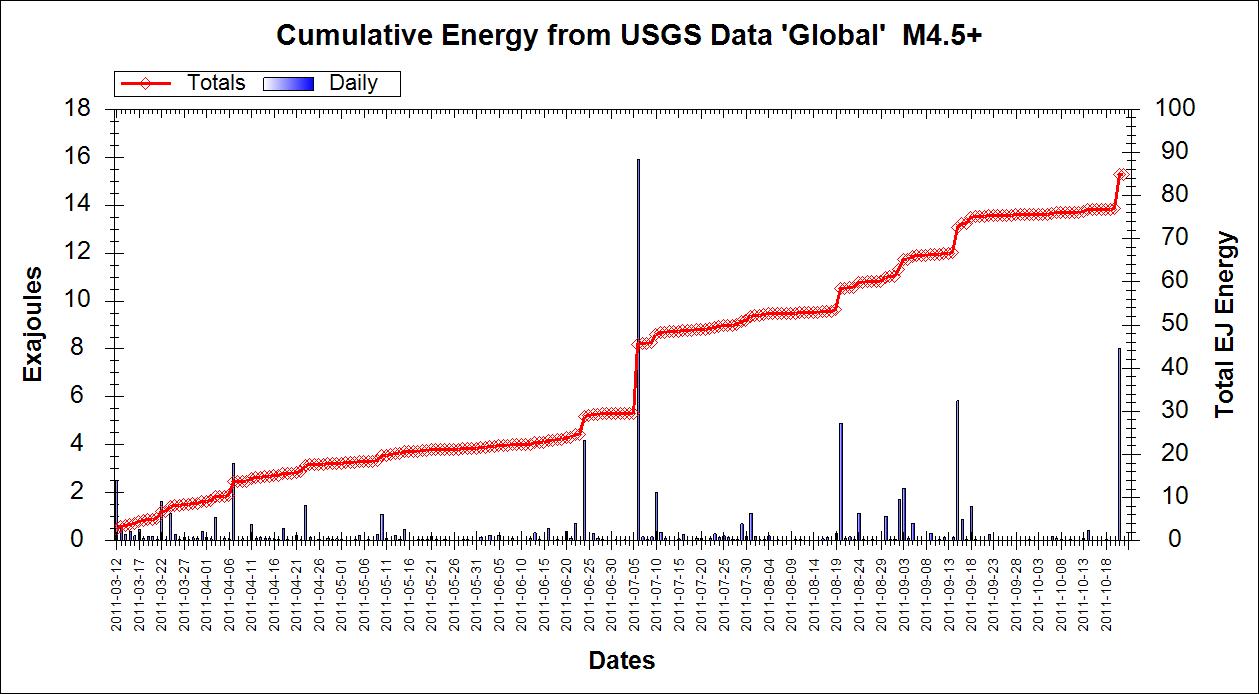
The two big spikes are the two large Kermedec Islands quakes or 7.6 and 7.4. Now I wind it back one day to include the Japan quake.
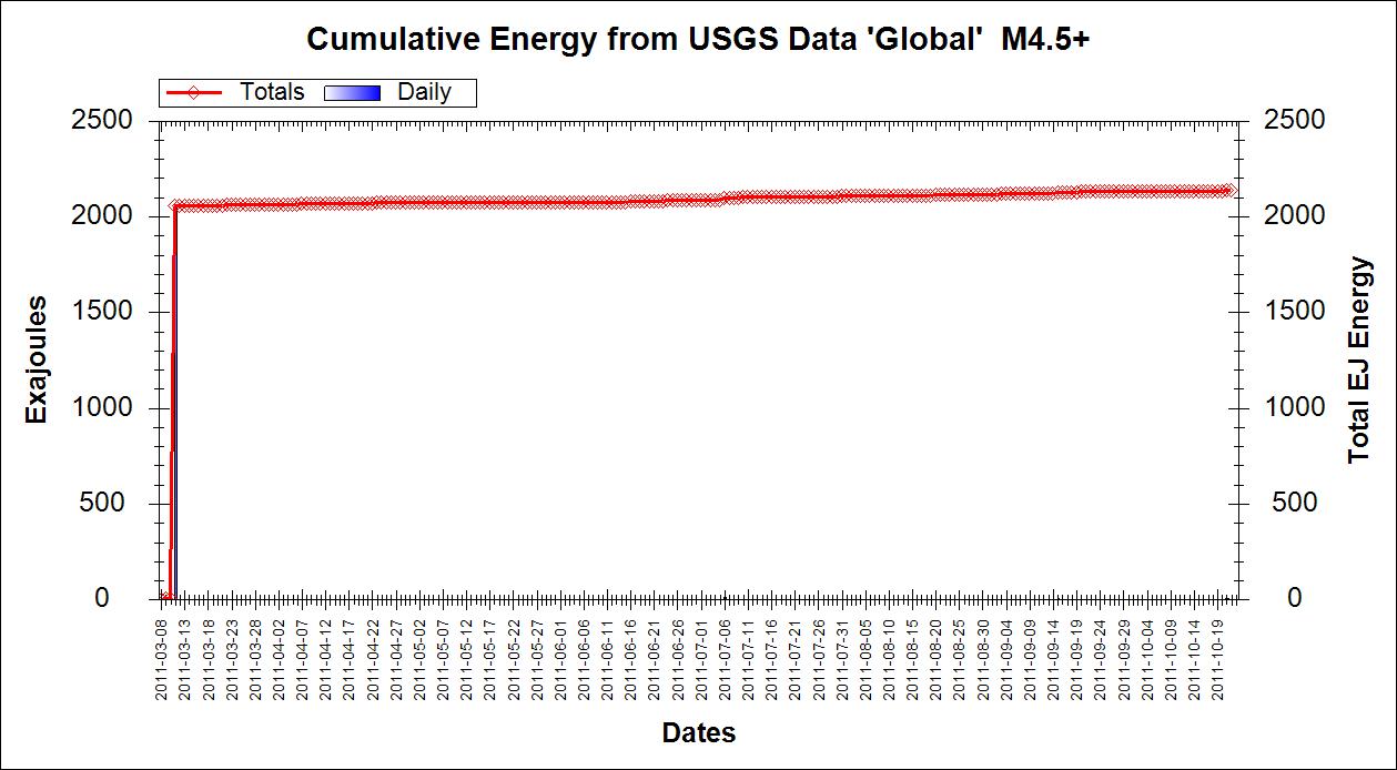
The total energy leaps from around 85 Petajoules to 2150 Petajoules.
It physically is not possible for the area around Fukushima to build up enough energy in that short period of time to produce another 9.0
That 9.1 was completely unexpected, in the sense that there was not any evidence of previous quakes of that magnitude in that area. Before March the Honshu off shore area produced around 3 or so Mag 6 quakes a year on average. The time taken to build up to that big one many well have been centuries. People seem to forget that Mother Nature and her Geology do not work on our time scales.
The geometry in that area is complex, but the release of such a massive amount of stress as was occasioned in the Tohoku quake in my opinion precludes the possibility of this happening again in that area for a very long time. Whilst you cannot apply statistics accurately to earthquakes it is never the less a fact that stress has to build up and all things being equal that build up takes a defined amount of time. Many factors play on the release mechanism, including the release of stress in other areas which may increase stress nearby. At the end of the day however statistics can give us an idea of how long it may be between major quakes.
Statistically another mega-quake has not happened inside a 12 month period other than in Alaska and Indonesia. In the relatively few other areas where mega-quakes have taken place, including Japan, it has been decades between events. It is also interesting that these two areas are also the only two that have exhibited the 1 mag less rule for aftershocks, if you count the second mega-quake as an aftershock. This does not happen in any other area for mega-quakes but is often seen for quakes around mag 7.
The Japanese have been stating for year that there will be a mega-quake which they call the Tokai (Tokyo) earthquake, but that is on a different plate boundary. Despite their calculations and protestations it has not happened and they got sideswiped by Tohoku which they did not predict.
In my opinion there is a negligible chance of a mag 9.0 earthquake in the same location as the 9.1 in March for many years to come, and certainly not by February.
In my opinion this will not happen. I have no idea why these people are sounding off on this but just take a look at the facts.
A 9.1 earthquake was a MASSIVE amount of energy release. It dwarfs the whole of the rest of the energy released in the world for the rest of the year.
Here is the energy releasd SINCE Japan, not including Japan. (Please note that due to an error in my program in the text fields this is labelled Exajoules whereas it is actually Petajoules)
The two big spikes are the two large Kermedec Islands quakes or 7.6 and 7.4. Now I wind it back one day to include the Japan quake.
The total energy leaps from around 85 Petajoules to 2150 Petajoules.
It physically is not possible for the area around Fukushima to build up enough energy in that short period of time to produce another 9.0
That 9.1 was completely unexpected, in the sense that there was not any evidence of previous quakes of that magnitude in that area. Before March the Honshu off shore area produced around 3 or so Mag 6 quakes a year on average. The time taken to build up to that big one many well have been centuries. People seem to forget that Mother Nature and her Geology do not work on our time scales.
The geometry in that area is complex, but the release of such a massive amount of stress as was occasioned in the Tohoku quake in my opinion precludes the possibility of this happening again in that area for a very long time. Whilst you cannot apply statistics accurately to earthquakes it is never the less a fact that stress has to build up and all things being equal that build up takes a defined amount of time. Many factors play on the release mechanism, including the release of stress in other areas which may increase stress nearby. At the end of the day however statistics can give us an idea of how long it may be between major quakes.
Statistically another mega-quake has not happened inside a 12 month period other than in Alaska and Indonesia. In the relatively few other areas where mega-quakes have taken place, including Japan, it has been decades between events. It is also interesting that these two areas are also the only two that have exhibited the 1 mag less rule for aftershocks, if you count the second mega-quake as an aftershock. This does not happen in any other area for mega-quakes but is often seen for quakes around mag 7.
The Japanese have been stating for year that there will be a mega-quake which they call the Tokai (Tokyo) earthquake, but that is on a different plate boundary. Despite their calculations and protestations it has not happened and they got sideswiped by Tohoku which they did not predict.
In my opinion there is a negligible chance of a mag 9.0 earthquake in the same location as the 9.1 in March for many years to come, and certainly not by February.
reply to post by PuterMan
Thank you for that graphs ..
Peace ..
Thank you for that graphs ..
Peace ..
edit on 30-10-2011 by Dalke07 because: (no reason given)
reply to post by murkraz
Didn't one of Edgar Cayce's prophecies say that the lower portion of Japan must go under the sea in order for the next set of events to take place. What if this is actually coming to fruition? I'll try to find the source for this.
Didn't one of Edgar Cayce's prophecies say that the lower portion of Japan must go under the sea in order for the next set of events to take place. What if this is actually coming to fruition? I'll try to find the source for this.
hmm,
when was there an M9 quake in Japan before?
oh, you mean the "9.1" reported by the USGS in March 2011?
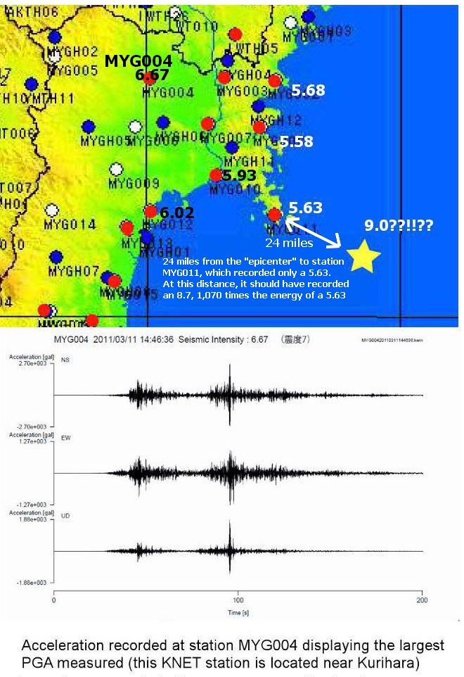
not the 6.67 max recorded at MYG004, one of the hundreds of earthquake sensors in Japan?
www.kz.tsukuba.ac.jp...
perhaps another reason may be pertinent for why a 'M9" may hit Japan before Feb 2012........
when was there an M9 quake in Japan before?
oh, you mean the "9.1" reported by the USGS in March 2011?
not the 6.67 max recorded at MYG004, one of the hundreds of earthquake sensors in Japan?
www.kz.tsukuba.ac.jp...
perhaps another reason may be pertinent for why a 'M9" may hit Japan before Feb 2012........
edit on 30-10-2011 by Highlander64 because: add
pic
reply to post by vox2442
I'm so glad you posted this, and yes, it was a fascinating read.
I personally feel they are on to something. An anomaly in a VHF band, 4 to 6 weeks in advance of a major quake is quite acceptable to me. The Earth is how many times bigger than a human? (quick trip to Wolfram Alpha haha) Earth is like 1.31466 x 10^25 lbs. We're 180 lbs.
So maybe time, from Earths perspective, and the unfolding of events is vastly slower.
Maybe the anomaly occurring 4 or 8 weeks before a quake is lightening quick for the Earth.
reply to post by Highlander64
Please take the time to read this link:
Japan Meteorological Agency Seismic Intensity Scale.
It might help you understand a few things.
Please take the time to read this link:
Japan Meteorological Agency Seismic Intensity Scale.
It might help you understand a few things.
Originally posted by vox2442
reply to post by Highlander64
Please take the time to read this link:
Japan Meteorological Agency Seismic Intensity Scale.
It might help you understand a few things.
I have seen that before
and the highest ground acceleration recorded was at MYG0011 fits a 5 on the shinto scale
MYG0011 is out on the peninsula 27 miles from the supposed epicentre - higher shinto scale readings happened inland like MYG0004 which means the epicentre was inland
(wiki) - note no quakes or tsunamis related to fukushima province ....
The Sanriku coast of Japan has experienced significant seismic activity. On June 15, 1896, an earthquake measuring 8.5 M, the 1896 Meiji-Sanriku earthquake occurred off the coast of Sanriku in Iwate Prefecture, causing a tsunami of 25 metres (82 ft) 35 minutes after the quake which destroyed hundreds of houses and killed over 27,000 people. Tsunami were also observed in Hawaii and in California
en.wikipedia.org...
it might help You understand a few things when you see what a "9.1" can do and the effects that should have been seen. a 9.1 would be equivalent or higher than the 7 on the shinto - apparently Japan has never had a M9 quake....and you can see people being none too displaced by the 'massive' quake in the videos from march 2011
en.wikipedia.org...
how about Alaska 9.2 1964?
en.wikipedia.org...
extract from above link re Alaska
The powerful earthquake produced earthquake liquefaction in the region. Ground fissures and failures caused major structural damage in several communities, much damage to property and several landslides. Anchorage sustained great destruction or damage to many inadequately engineered houses, buildings, and infrastructure (paved streets, sidewalks, water and sewer mains, electrical systems, and other man-made equipment), particularly in the several landslide zones along Knik Arm.
Two hundred miles southwest, some areas near Kodiak were permanently raised by 30 feet (9.1 m). Southeast of Anchorage, areas around the head of Turnagain Arm near Girdwood and Portage dropped as much as 8 feet (2.4 m), requiring reconstruction and fill to raise the Seward Highway above the new high tide mark.
In Prince William Sound, Port Valdez suffered a massive underwater landslide, resulting in the deaths of 30 people between the collapse of the Valdez city harbor and docks, and inside the ship that was docked there at the time. Nearby, a 27-foot (8.2 m) tsunami destroyed the village of Chenega, killing 23 of the 68 people who lived there; survivors out-ran the wave, climbing to high ground.
Post-quake tsunamis severely affected Whittier, Seward, Kodiak, and other Alaskan communities, as well as people and property in British Columbia, Oregon, and California. Tsunamis also caused damage in Hawaii and Japan. Evidence of motion directly related to the earthquake was reported from all over the earth.
Twelve people were killed by the tsunami in or near Crescent City, California, while four children were killed on the Oregon coast at Beverly Beach State Park.Other towns along the U.S. Pacific Northwest and Hawaii were damaged. Minor damage to boats reached as far south as Los Angeles.
As the entire planet vibrated as a result of the quake, minor effects were felt worldwide. Several fishing boats were sunk in Louisiana, and water sloshed in wells in Africa
and of course all the above happened in Japan and the rest of the world in march 2011.......
ever wonder why the tsunami warnings did not go off in Japan?
edit on 30-10-2011 by Highlander64 because: (no reason
given)
edit on 30-10-2011 by Highlander64 because: (no reason given)
Originally posted by Highlander64
ever wonder why the tsunami warnings did not go off in Japan?
No, I don't.
Because like everyone else living in a coastal region of Japan on March 11th, I heard them go off just before 3:00 pm. And they continued for several hours. It's cemented into my memory as much as anything else that day.
I think it is much, much better a Mag.9 strikes here in Greater Nihon than somewhere in Indonesia,
Turkye, China, etc. because we here can stand a EQ of this Magnitude more or less but with
a lower amount of Deaths!
We are in a way ready for EQ. and we are awaiting them,
since 03/11 we are all awake and do not even relax for a Night in Peace
But we also have F'Shima and i am sure that a Mag. 7,5 and higher would kill
many People in the Americas as well here in Asia!
They should remove the Fuel from the Pools as much as possible,
even a reduction of 20% will lower the Death Toll!
reply to post by Highlander64
There is a report posted by me but i cant find it at the moment
but this may help you to understand a point of confusion!
The Japanese never said it was/ is a Mag.9,1 Quake,
for Japan it was a "Shindo 7" and the Measurement was something above Mag.8,2!
The Mag8,9 and than later Mag 9 and Mag 9,1 came from the US-American Data Center!
I will look for this Article
reply to post by PuterMan
OF COURSE,
my even questioning your expertise in this field is like a piss-ant trying to joust with an elephant.
Nevertheless, for argument's sake . . .
given that we do live in
'interesting times,'
PRETENDING FOR A MOMENT that such a quake DOES occur in some such locations wherein one would logically think that all great stresses had been relieved by the earlier large quake . . .
What PERCENTAGE of . . adjustment . . .
of your constructions on quake realities would that trigger?
I consider you amongst the best 3 or so experts I have ready access to. And I'm trying to get a handle on what potential changes in understandings may be ahead . . . perhaps not in this specific case but generally on such topics in this era.
Because I certainly am convinced that MANY such understandings will have to be trashed before it's all over and the literal Armageddon is finished.
reply to post by Human0815
This is to be expected because JMO and the various report from the Japanese Ministries and Universities all refer to the Richter scale. At these levels the Richter ML scale is saturated and it is not possible to get an accurate reading on the scale. I note however that the Foreign Ministry and Tohoku University bother refer to it as 9.0 on the Richter scale.
You perhaps recall that until recalculated using the Mw scale the largest earthquakes in the world (Chile 1960) was recorded as an 8.8 on the Richter scale. This would certainly be in keeping with "something above Mag.8,2!" fi you see what I mean.
was something above Mag.8,2!
This is to be expected because JMO and the various report from the Japanese Ministries and Universities all refer to the Richter scale. At these levels the Richter ML scale is saturated and it is not possible to get an accurate reading on the scale. I note however that the Foreign Ministry and Tohoku University bother refer to it as 9.0 on the Richter scale.
You perhaps recall that until recalculated using the Mw scale the largest earthquakes in the world (Chile 1960) was recorded as an 8.8 on the Richter scale. This would certainly be in keeping with "something above Mag.8,2!" fi you see what I mean.
new topics
-
Shocking Number of Voters are Open to Committing Election Fraud
US Political Madness: 43 minutes ago -
Gov Kristi Noem Shot and Killed "Less Than Worthless Dog" and a 'Smelly Goat
2024 Elections: 1 hours ago -
Falkville Robot-Man
Aliens and UFOs: 1 hours ago -
James O’Keefe: I have evidence that exposes the CIA, and it’s on camera.
Whistle Blowers and Leaked Documents: 2 hours ago -
Australian PM says the quiet part out loud - "free speech is a threat to democratic dicourse"...?!
New World Order: 3 hours ago -
Ireland VS Globalists
Social Issues and Civil Unrest: 3 hours ago -
Biden "Happy To Debate Trump"
Mainstream News: 4 hours ago -
RAAF airbase in Roswell, New Mexico is on fire
Aliens and UFOs: 4 hours ago -
What is the white pill?
Philosophy and Metaphysics: 5 hours ago -
Blast from the past: ATS Review Podcast, 2006: With All Three Amigos
Member PODcasts: 6 hours ago
top topics
-
A Warning to America: 25 Ways the US is Being Destroyed
New World Order: 14 hours ago, 21 flags -
Blast from the past: ATS Review Podcast, 2006: With All Three Amigos
Member PODcasts: 6 hours ago, 11 flags -
Biden "Happy To Debate Trump"
Mainstream News: 4 hours ago, 8 flags -
Mike Pinder The Moody Blues R.I.P.
Music: 6 hours ago, 7 flags -
James O’Keefe: I have evidence that exposes the CIA, and it’s on camera.
Whistle Blowers and Leaked Documents: 2 hours ago, 5 flags -
Australian PM says the quiet part out loud - "free speech is a threat to democratic dicourse"...?!
New World Order: 3 hours ago, 5 flags -
What is the white pill?
Philosophy and Metaphysics: 5 hours ago, 5 flags -
Ireland VS Globalists
Social Issues and Civil Unrest: 3 hours ago, 4 flags -
RAAF airbase in Roswell, New Mexico is on fire
Aliens and UFOs: 4 hours ago, 4 flags -
Putin, Russia and the Great Architects of the Universe
ATS Skunk Works: 9 hours ago, 3 flags
active topics
-
Candidate TRUMP Now Has Crazy Judge JUAN MERCHAN After Him - The Stormy Daniels Hush-Money Case.
Political Conspiracies • 806 • : Annee -
The functionality of boldening and italics is clunky and no post char limit warning?
ATS Freshman's Forum • 14 • : Encia22 -
MULTIPLE SKYMASTER MESSAGES GOING OUT
World War Three • 99 • : cherokeetroy -
University of Texas Instantly Shuts Down Anti Israel Protests
Education and Media • 298 • : CriticalStinker -
Gov Kristi Noem Shot and Killed "Less Than Worthless Dog" and a 'Smelly Goat
2024 Elections • 25 • : FlyersFan -
Falkville Robot-Man
Aliens and UFOs • 4 • : Kurokage -
Shocking Number of Voters are Open to Committing Election Fraud
US Political Madness • 1 • : YourFaceAgain -
-@TH3WH17ERABB17- -Q- ---TIME TO SHOW THE WORLD--- -Part- --44--
Dissecting Disinformation • 700 • : Thoughtful3 -
Putin, Russia and the Great Architects of the Universe
ATS Skunk Works • 26 • : RussianTroll -
Re-election Tactic - JOE BIDEN Hints He May Put Books in the Homes of Black People.
2024 Elections • 30 • : WeMustCare