It looks like you're using an Ad Blocker.
Please white-list or disable AboveTopSecret.com in your ad-blocking tool.
Thank you.
Some features of ATS will be disabled while you continue to use an ad-blocker.

Proof: Station on MARS
page: 20share:
Originally posted by saturnus1962
This certainly is a good find. But like many others have pointed out, it's no "proof". I would really like to believe there is a structure like that on Mars and have the discussion of life on other planets over with.
Unfortunately this is not the proof everybody is waiting for. There are a few reasons for me to say this:
- I can't find it anywhere that Google Mars is a reliable source to make these kind of investigations (and resulting claims)
- The picture is too blurry to make any statements or to draw any conclusions
- The location of the object (if it is a building) doesn't show any particular reason, why it is on that exact spot (missing other details like a "lake" or "road")
- If not naturaly formed it also could be remains of the numerous crashed probes (and there are really a lot)
Of course I hope I'm proven wrong!
With respect there is blurriness and then there is blurriness , yes the image is blurred but i feel not to the degree that nothing cannot be made out or perceived as shapes;The video is impressive and does show to a degree certain traits of cylinder type shapes;
Cheers!
Originally posted by Frira
Six pages into comments, and I became impatient, so pardon me if others have posted these:
1. I do not know if the measure tool on Google Earth is calibrated for planet viewing, but the object measures right around 200 meters in length using that tool.
2. Backing off (note how Google Earth altitude is obviously not calibrated for Mars view) gives a better view. The algorithm used to calculate altitude most certainly effects the measurement tool.
3. Other sources have been posted showing the same object as it appears in Google Earth, so we can cease the debate about a Google hoax.
4. We do not have the technology to send men to Mars. If we did, we would not be wasting huge amounts of money on ISS and STS missions, would we?
5. Concerning if we could be looking at a rocket stage which impacted there after delivering a orbital or lander payload (if anyone may have thought of that): any such man-made object would be far too small to show up except perhaps as a bright dot of light.
6. A brief post by some user stated that the same image appears on earth at the same coordinates. No. Neither does that series of pixels show up on the Lunar view. Besides, see item 3, above.
7. A database I found indicating locations of man-made debris on Mars does not show anything near this position. See: Mars debris and lander sites
Size estimate: As I hinted at in the first two items, the altitude provided by Google Earth allows you to zoom in to about a MINUS 17,000 feet-- the apparent "surface" level. No matter what altitude one uses, the object measures right around 200 meters. That suggests to me that the displayed altitude for whatever zoom level one chooses is not a number used to calculate measurement when using the ruler tool.
Google Earth Measurement of object = 200 meters
Mars diameter/radius: 6790/3395 kilometers
Earth diameter/radius: 12670/6335 kilometers
If the algorithm used to calculate measurement is based, not upon altitude, but from arc seconds-- essential calculating from the center of the planet-- then correcting the algorithm (if any is required) may cause us to suspect that the measurement tool is over-estimating the size, because the shortest distance between two lines making up an angle gets greater the farther from the intersection one measures.
So, If Google Earth calculates measurement between two points on Mars based upon degree of separation but, erroneously using Earth's diameter, then it is calculating the distance between two points on an angle about 2940 kilometers beyond the actual (the difference between surface level of earth and of Mars if those imaginary surfaces were calculated from the same central point). The actual length of object can be determined by cross multiplication as: 200/6335 = x/3395; thus x = ~107 meters.
Conclusion (unless someone has more data): We are not looking at anything man-made. I do not believe we have sent even a booster of near that length. 100 meters would be typical of a booster needed to escape earth's gravity, but a trans-Mars stage would not be so large, would it?
Superb post, yes i see where you are coming from, good digging;
does this lend more credence to Esienhower's great granddaughter who said she had been recruited to go to the Mars Colony?
www.examiner.com...
www.examiner.com...
I believe it is a genuine structure on Mars. Based on my own intensive
research since 2004, this image is just one of thousands of images that suggests
there was an ancient (intelligent) civilization on Mars. I would like to suggest the
possibility that this structure may actually be even larger than 700' by 150'. Isn't it possible that
what we are seeing is just the "tip of the iceburg", and more structure may actually
be buried under billions of years of dust and dirt? Also, I wanted to point out something
else that has not been mentioned here on this thread:
33'06.53'W........ well folks, that coordinate is not far off from 35 degrees which as many of us
know here at ATS represents sacred locations on Mars (Cydonia for example) and on
Earth.....the Giza Plateau in Egypt for example. OK it is 33', however if a majority
of the structure is buried and actually covers a much wider area, then it is conceivable
that a portion of the structure is located at 35 degrees!!! Just another coincidence?,
I don't think so, IMHO !!!!! One more thing.....I notice that the other coordinate is 71 49'19.73'N
........35 x 2 is 70......it may mean nothing but who knows?????
reply to post by Phage
I think it is rude for you to imply that I have "distorted" all of my comments. You have
indicated a different coordinate for Cydonia....OK fine, however that does not negate the
fact that (after doing more research on the web before posting this) there is a pattern regarding
33 degrees (not 35 degrees as I mis-stated in my previous post). Actually, this is good
news for me since the "structure" we have been discussing on this thread is located at 33'.
There are many sacred sites and events that have taken place at the 33rd parellel and there are, in fact, scientists that have shown mathematical and astronomical correlations between Earth and Mars. What that may mean speciifically is still open for honest debate and discussion.
I also just found this on a site which I thought was relevant regarding 33 degrees, etc. www.activistpost.com...
Side note: I'm a nice person and it saddens me how many nasty people are allowed to post on ATS.
reply to post by SusanForKucinich
I think it is overly defensive for you to react this way. I simply pointed out that you were mistaken in the location of Cydonia.
You are now confusing latitude with longitude. The 33rd parallel is a latitude (N-S). The image flaw being discussed in this thread is near 33W, that is a longitude (E-W).
Do you think it is nasty to be informed that your information is incorrect? How are you going to learn anything if you react that way?
reply to post by SusanForKucinich
I just love mars artifacts. This is artificial, no argument, too circular and too structured. Just google NASA's lookout pan and its slap bang in the middle
I just love mars artifacts. This is artificial, no argument, too circular and too structured. Just google NASA's lookout pan and its slap bang in the middle
edit on 02/07/2011 by breadmaker99 because:
picture
edit on 02/07/2011 by breadmaker99 because: (no reason given)
To me this NASA link explains what is happening..if I am wrong...I apologize ahead of time...but this article made sense to me.
Ok folks for some reason NASA would not let me post the link....so please on this thread ...just ignore me!
editby]edit on 5-6-2011 by caladonea because: correct link
Ok folks for some reason NASA would not let me post the link....so please on this thread ...just ignore me!
editby]edit on 5-6-2011 by caladonea because: correct link
edit on 5-6-2011 by caladonea because: (no reason
given)
edit on 5-6-2011 by caladonea because: remove link


This might be of interest.
The Space Program and the Military Industrial Complex.
Arsenal of Hypocrisy
The Space Program and the Military Industrial Complex.
Arsenal of Hypocrisy
edit on 5-6-2011 by
spinkyboo because: added line
I have noticed some say things like, it is impossible for an object to cast two shadows without to separate light sources. I have read that this
nothing more than a photo artifact or a natural outcropping of rock that resembles something it isn't. These are all great points, but not
necessarily true.
While I in no way will allow myself to believe that this is some kind of mmmmm Mars habitat, I cant help but feel it has a remarkably uncanny resemblance to models that have been artistically rendered.
First to address the "double shadow" issue. If you have a noon day sun give or take an hour or so shinning on a cylindrical object lying on the ground, you will have a shadow form under both sides of the cylinder; thereby creating a double shadow.
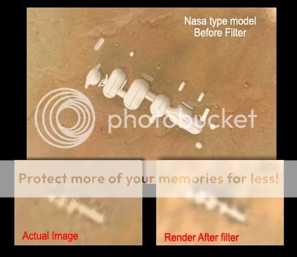
Because I was bored, I decided to see if these objects making up this alleged planetary base could turn into something then turn back into themselves via pixelation. Below are my results.
First I took the actual photo and roughly drew a pattern of objects similar to various proposed lunar and martian living habitats.
I then filtered the image as close as possible to what occurs with the zoom feature on google. I find it interesting that the object in question appears almost exactly like the computer rendered object. So if one were to clear up the image you might get the actual image seen in the larger photo.
The emphasis is on the straight lines and the shadows. This is as opposed to natural formations that might yield very different results with the same filters. I am being biased here and not presenting an image of what a natural formation may look like under similar circumstances, I am working on that.
Anyway I hear the arctic area is where the interest is.
While I in no way will allow myself to believe that this is some kind of mmmmm Mars habitat, I cant help but feel it has a remarkably uncanny resemblance to models that have been artistically rendered.
First to address the "double shadow" issue. If you have a noon day sun give or take an hour or so shinning on a cylindrical object lying on the ground, you will have a shadow form under both sides of the cylinder; thereby creating a double shadow.
Because I was bored, I decided to see if these objects making up this alleged planetary base could turn into something then turn back into themselves via pixelation. Below are my results.
First I took the actual photo and roughly drew a pattern of objects similar to various proposed lunar and martian living habitats.
I then filtered the image as close as possible to what occurs with the zoom feature on google. I find it interesting that the object in question appears almost exactly like the computer rendered object. So if one were to clear up the image you might get the actual image seen in the larger photo.
The emphasis is on the straight lines and the shadows. This is as opposed to natural formations that might yield very different results with the same filters. I am being biased here and not presenting an image of what a natural formation may look like under similar circumstances, I am working on that.
Anyway I hear the arctic area is where the interest is.
reply to post by snowen20
First you made a model which resembled the processed Google image.
Why speculate about what the "cleared up" image would look like when we have the original?
www.abovetopsecret.com...
It is not a natural formation. It is a digital image artifact.
First I took the actual photo and roughly drew a pattern of objects similar to various proposed lunar and martian living habitats.
First you made a model which resembled the processed Google image.
Why speculate about what the "cleared up" image would look like when we have the original?
www.abovetopsecret.com...
It is not a natural formation. It is a digital image artifact.
reply to post by Phage
Phage?
I said I was bored.
I said I was being biased in my view
I said I don't believe it.
It is all BS, Phage.
Phage?
I said I was bored.
I said I was being biased in my view
I said I don't believe it.
It is all BS, Phage.
IM very ignorant but if sll those are just camera tricks,megapixels errors, imagens that are blurrs and wopss,why the landscape dont look all
the same??????????,i mean why somebody has to find it rigth???...BE honest those images are very suspicious,either if is a pointer from a
computer[never heard of it being an error in an image,unless is very obvious]but being a debunker myself this is a very weird pics and stats are
more speculative and provocative this time around.
YouTube VIDEO
This should raise a few eyebrows at NASA
This should raise a few eyebrows at NASA
edit on 02/07/2011 by breadmaker99 because: (no reason given)
And while the conversation and discussion rolls along-- the answer remains in the Phage's post (from page 16) which I copy (again) just to make it
easier...
So now, I'll show you what it looks like when you overlay:
Source Image:
[atsimg]http://files.abovetopsecret.com/images/member/368b5eec6997.png[/atsimg]
Google Earth Image superimposed with Source Image:
[atsimg]http://files.abovetopsecret.com/images/member/d0be65938caa.png[/atsimg]
Google Earth Image alone:
[atsimg]http://files.abovetopsecret.com/images/member/73f6201fc4dd.png[/atsimg]
Looks very much to me that we are done:
* The sand dunes line up.
* The source image is clearly missing bits-- big white pixel blocks of missing data
* The long solid bar on the right side with dashes to left.
* Image processing attempts to average with surrounding pixels.
* Voila! A simple signal glitch provide a very reasonable answer.
I'm satisfied. Anyone not?
Originally posted by Phage
For those who seem to have not bothered (it helps to follow the thread).
The source image which Google used is from ESA's Mars Express orbiter, using the high resolution stereo camera. The image ID: H5620_0000_ND2
You can find it here:
HRSC viewer
If you want to download the full image you can get it here:
psa.esac.esa.int...
It is large, 355 MB. You will need a viewer to decode the image. You can get that here:
pds.nasa.gov...
This is what it looks like at full native resolution:
[atsimg]http://files.abovetopsecret.com/images/member/d4a0268cb01e.gif[/atsimg]
This is what it looks like zoomed 300%
[atsimg]http://files.abovetopsecret.com/images/member/5d7510372308.png[/atsimg]
It is obviously an image artifact in the source image. Note the one pixel spacing. Note that the pixels are in a horizontal line across the image.edit on 6/2/2011 by Phage because: (no reason given)edit on 6/2/2011 by Phage because: (no reason given)edit on 6/2/2011 by Phage because: (no reason given)
So now, I'll show you what it looks like when you overlay:
Source Image:
[atsimg]http://files.abovetopsecret.com/images/member/368b5eec6997.png[/atsimg]
Google Earth Image superimposed with Source Image:
[atsimg]http://files.abovetopsecret.com/images/member/d0be65938caa.png[/atsimg]
Google Earth Image alone:
[atsimg]http://files.abovetopsecret.com/images/member/73f6201fc4dd.png[/atsimg]
Looks very much to me that we are done:
* The sand dunes line up.
* The source image is clearly missing bits-- big white pixel blocks of missing data
* The long solid bar on the right side with dashes to left.
* Image processing attempts to average with surrounding pixels.
* Voila! A simple signal glitch provide a very reasonable answer.
I'm satisfied. Anyone not?
reply to post by breadmaker99
Breadmaker, If you think you have something anomalous then start a thread with the the images included. This thread has already dragged on for too long and your images will get due attention if you start a thread with them
The result may well be that they can be explained so try not to be too disappointed. However, we all learn as much from that as anything else but the middle of this way too long thread isn't the place.
edit on 5/6/11 by Pimander because: typo