It looks like you're using an Ad Blocker.
Please white-list or disable AboveTopSecret.com in your ad-blocking tool.
Thank you.
Some features of ATS will be disabled while you continue to use an ad-blocker.

Quake Watch 2011
page: 409share:
Originally posted by PuterMan
reply to post by muzzy
Your missing quake just turned up.
Date/Time UTC,Latitude,Longitude,Magnitude,Depth(Km),Location
2011-12-28 07:04:32, -40.281, 174.346, 2.1, 71.9, Graham Bank
Source: GeoNet Magma.XML
ETA: You might have felt that one muzzy! Location in Google Maps
edit on 28/12/2011 by PuterMan because: (no reason given)
No I don't think thats it.Even local mag 4.5's don't show on LISS SNZO
While I was doing something else ( having a nap ) another one came up on LISS.
Started going through the LISS graphs and saved these (all the stations showing the traces)
I was going to post that it might be in the south part of F-E Region 43
Southeast Central Pacific Ocean
Southern East Pacific Rise
Chatham Islands. N.Z. Region
South Of Chatham Islands
Pacific-Antarctic Ridge
Southern Pacific Ocean
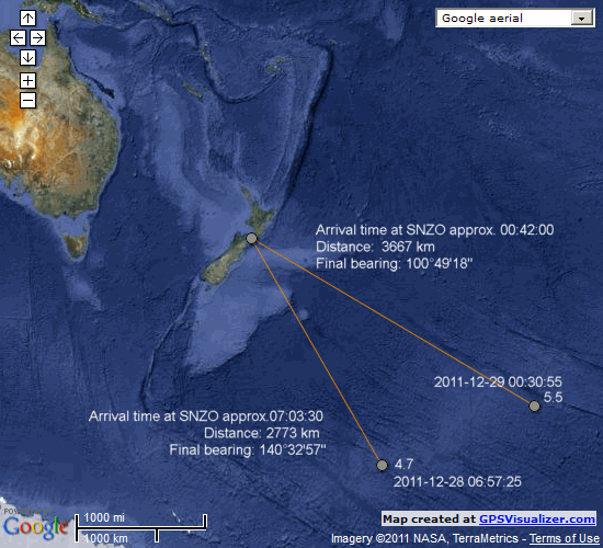
As it turned out USGS found the latest one
Magnitude 5.5
Date-Time
Thursday, December 29, 2011 at 00:30:56 UTC
Wednesday, December 28, 2011 at 03:30:56 PM at epicenter
Location 58.400°S, 139.690°W
Depth 16.9 km (10.5 miles)
Region PACIFIC-ANTARCTIC RIDGE
Distances 1826 km (1134 miles) NNW of Mt. Siple, Antarctica
2236 km (1389 miles) E of Scott Island, Antarctica
2253 km (1399 miles) WSW of Swain's Island
3686 km (2290 miles) SE of WELLINGTON, New Zealand
Location Uncertainty horizontal +/- 18.6 km (11.6 miles); depth +/- 4.8 km (3.0 miles)
Parameters NST=125, Nph=132, Dmin=>999 km, Rmss=1.09 sec, Gp= 54°,
M-type=body wave magnitude (Mb), Version=7
Source
Magnitude: USGS NEIC (WDCS-D)
Location: USGS NEIC (WDCS-D)
Event ID usc0007e2u
As has happened in the past I think the earlier one was the same region maybe a 5.0-5.2
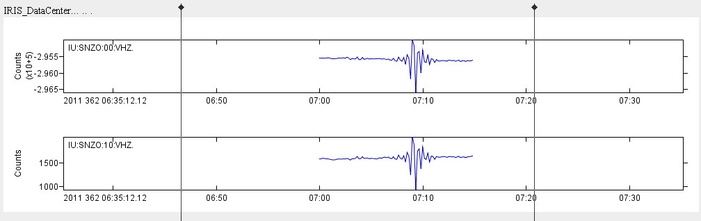
While I was looking around i noticed at the bottom of LISS SNZO they have the channel LHZ, but on BUD there is nothing to see
reply to post by muzzy
Yes you are right. It came through on the screen, I posted the message to you and really did not even think about it. Bad Science Mr PuterMan!!
The VHZ channel shows the quake: SNZO.IU.00.VHZ.2011.362 and if I put the waveform into my program
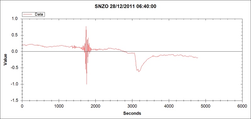
(or look at it in Vase)
it is possible to get a rough estimate of the P/S arrival difference of ~220 seconds. Using 6 km/s that means the event was ~1320 km from SNZO. It could be further as the sound of the quake has to be speeded up considerably to hear it and that is always indicative of a quake a couple of thousand miles away.
1320 puts it by the Auckland Islands and 1760 (8 km/s) puts it by Macquarie Island.
If I have time later I might see if I can triangulate some of the others to pinpoint the area better.
ETA: Just a quick estimate. QSPA looks as if it is about 6 mins behind which at 6 km/s makes it around 3,600 km away which is about the distance from the station to Macquaire. 8 km/s puts it around Auckland Islands so it has to be one of those depending on the travel speed of the waves since they both about agree with each other.
Yes you are right. It came through on the screen, I posted the message to you and really did not even think about it. Bad Science Mr PuterMan!!
The VHZ channel shows the quake: SNZO.IU.00.VHZ.2011.362 and if I put the waveform into my program
(or look at it in Vase)
it is possible to get a rough estimate of the P/S arrival difference of ~220 seconds. Using 6 km/s that means the event was ~1320 km from SNZO. It could be further as the sound of the quake has to be speeded up considerably to hear it and that is always indicative of a quake a couple of thousand miles away.
1320 puts it by the Auckland Islands and 1760 (8 km/s) puts it by Macquarie Island.
If I have time later I might see if I can triangulate some of the others to pinpoint the area better.
ETA: Just a quick estimate. QSPA looks as if it is about 6 mins behind which at 6 km/s makes it around 3,600 km away which is about the distance from the station to Macquaire. 8 km/s puts it around Auckland Islands so it has to be one of those depending on the travel speed of the waves since they both about agree with each other.
edit on 29/12/2011 by PuterMan because: (no reason given)
This is really interesting. Great analysis and research. Good job!
reply to post by PuterMan
im not agree with you sorry..
2°14'41.14"N 65°24'36.87" O
photographic colouration here too ?
i dont think so...
(Its south venezuela)
I was sure i can find the same in amazonia because :
siberia/amazonia = same
if u find the same like this near a city, ok im wrong... but maybe not
im not agree with you sorry..
2°14'41.14"N 65°24'36.87" O
photographic colouration here too ?
i dont think so...
(Its south venezuela)
I was sure i can find the same in amazonia because :
siberia/amazonia = same
if u find the same like this near a city, ok im wrong... but maybe not
edit on 29-12-2011 by maritimo69 because: (no reason given)
reply to post by PuterMan
What doesn't help tracking these down is that usgs didn't list SNZO (or any other NZ station for that matter) in the
usgs phase data for the Pac-Ant Ridge 5.5 , despite SNZO being the 2nd largest trace on the LISS graphs
Often you can judge the direction from the size of the trace on those.
Too bad GFZ (Geofon) stopped publishing their phase data, it was a handy cross reference to usgs's.
I guess that 7:00:00 one might show up on the lists in 8 days
Pretty amazing that 5.5 showed on just about every LISS graph.
edit on 29-12-2011 by muzzy because: (no reason given)
reply to post by maritimo69
You say if this was near a city? Just what exactly do you think all those towns in the middle of the 'lava' on the link I gave in this post are? Asbestos townships floating in a lava sea?
I have suggested photographic effects, which may be along the lines of this
You may believe what you like. You asked a question, I gave you my opinion. As far as I am concerned that is an end to it. It is off topic for this thread. Much as I like to try and help where I can I would suggest that if you wish to continue it you could go and try the question on the people in Volcano Watch (see my signature) since it is volcano related.
The only other thing I can suggest is that you go to the forum on the Google Earth Community and pose your question there. I have no doubt someone will be able to tell you why the images are coloured as they are.
Interpreting land features (PPT)
ETA: One final thing, further investigation shows this to be a something to do with image resolution as it seems to appear in lower resolution image areas. Look at this location.
54.141372°, -9.560053°
If that was lava I would know it believe me since it is not far from my house. In fact I have travelled though that 'lava' and I can assure you that is just peat bog. Look at the next bit to the right in a higher resolution image. Different colour. Lava does not stop in straight lines.
You say if this was near a city? Just what exactly do you think all those towns in the middle of the 'lava' on the link I gave in this post are? Asbestos townships floating in a lava sea?
I have suggested photographic effects, which may be along the lines of this
You may believe what you like. You asked a question, I gave you my opinion. As far as I am concerned that is an end to it. It is off topic for this thread. Much as I like to try and help where I can I would suggest that if you wish to continue it you could go and try the question on the people in Volcano Watch (see my signature) since it is volcano related.
The only other thing I can suggest is that you go to the forum on the Google Earth Community and pose your question there. I have no doubt someone will be able to tell you why the images are coloured as they are.
Interpreting land features (PPT)
edit on 29/12/2011 by PuterMan because: (no reason given)
ETA: One final thing, further investigation shows this to be a something to do with image resolution as it seems to appear in lower resolution image areas. Look at this location.
54.141372°, -9.560053°
If that was lava I would know it believe me since it is not far from my house. In fact I have travelled though that 'lava' and I can assure you that is just peat bog. Look at the next bit to the right in a higher resolution image. Different colour. Lava does not stop in straight lines.
edit on 29/12/2011 by PuterMan because: (no reason given)
Interesting article in our local Christchurch paper this morning (the Press): POLICE QUIT HQ AFTER QUAKE FEARS
Basically they're frightened about the building's safety even though they've been assured by engineers that it's SAFE as.
Hey, many of us don't feel 'safe' in the buildings we live and or work in, but we've learnt to SUCK IT UP!
More interestingly though is the following statement in the article:
Gotta say that's not comforting reading...I mean what are they classing as BIG?
Should we even be looking at a CBD rebuild...?
If we get a strong 5.5+ early in the New Year (predicted), then I'm seriously thinking it's time to leave this city!
Basically they're frightened about the building's safety even though they've been assured by engineers that it's SAFE as.
Hey, many of us don't feel 'safe' in the buildings we live and or work in, but we've learnt to SUCK IT UP!
More interestingly though is the following statement in the article:
Last Friday's quakes had "added a degree of urgency" to the plans (apparently they had plans to vacate the building before the 2017 lease ended), and aftershock forecasts from GNS Science seismologists had suggested there was a chance the city would be hit by another BIG quake in the next year!
Gotta say that's not comforting reading...I mean what are they classing as BIG?
Should we even be looking at a CBD rebuild...?
If we get a strong 5.5+ early in the New Year (predicted), then I'm seriously thinking it's time to leave this city!
edit on 29-12-2011 by
SpaceJockey1 because: spelling
Originally posted by muzzy
reply to post by PuterMan
What doesn't help tracking these down is that usgs didn't list SNZO (or any other NZ station for that matter) in the
usgs phase data for the Pac-Ant Ridge 5.5 , despite SNZO being the 2nd largest trace on the LISS graphs
Often you can judge the direction from the size of the trace on those.
Too bad GFZ (Geofon) stopped publishing their phase data, it was a handy cross reference to usgs's.
I guess that 7:00:00 one might show up on the lists in 8 days
Pretty amazing that 5.5 showed on just about every LISS graph.
Found it!
F-E Region: Pacific Antarctic Ridge
Time: 2011-12-28 06:57:25.5 UTC
Magnitude: 4.7 (mb)
Epicenter: 164.40°W 63.00°S
Depth: 10 km
Status: M - manually revised
geofon.gfz-potsdam.de...
I mentioned GFZ this morning, but didn't bother to check the site at the time
SNZO graph again
ETA:
You can see why Geonet is teaming up with GFZ, they have a better result rate than USGS, there is something new called Geonet Rapid coming out in Jan.
edit on 29-12-2011
by muzzy because: (no reason given)
edit on 29-12-2011 by muzzy because: (no reason given)
Howdy friends! I hope everyone has a fabulous New Years (and a safe one)!
I'm just going to post the link to the article from one of our local news stations here in Salt Lake City, Utah. As I think the entire article is worthy of a read.
I for one, would LOVE to hear Robin/Eric's take on this. Especially since this falls right in line with some of his theories!
Source - KSL News - Hurricanes cause earthquakes? Apparently, yes!
reply to post by SpaceJockey1
Lets hope they do dwindle off. A lot of people are hanging out waiting for the rebuild to start, let alone the homeowners, the rest of the country is in recession in the construction industry. Its even an option I'm considering myself it things get any worse here in Wgtn.
Speaking of reading the newspaper, I was reading that over in the UK the construction industry is expecting a further 35% drop in business this next year, so there is likely to be an influx of Poms for the rebuild .......... if they can handle the shaking.
Another one
This time USGS the first to list it.
in between the first two that GFZ found
I wonder what influence these quakes are having on the movement towards NZ's South Island, being a spreading ridge area, pushing the Pacific Plate NW?
Time will tell, in the next few days I guess.
This time USGS the first to list it.
in between the first two that GFZ found
Magnitude 4.6
Date-Time
Friday, December 30, 2011 at 12:17:44 UTC
Friday, December 30, 2011 at 02:17:44 AM at epicenter
Location 58.436°S, 149.149°W
Depth 10 km (6.2 miles)
Region PACIFIC-ANTARCTIC RIDGE
Distances 1839 km (1142 miles) ENE of Scott Island, Antarctica
2018 km (1253 miles) NW of Mt. Siple, Antarctica
2285 km (1419 miles) SE of Antipodes Island, New Zealand
3156 km (1961 miles) SE of WELLINGTON, New Zealand
Location Uncertainty horizontal +/- 28.7 km (17.8 miles); depth +/- 3.4 km (2.1 miles)
Parameters NST= 14, Nph= 14, Dmin=>999 km, Rmss=0.41 sec, Gp=173°,
M-type=body wave magnitude (Mb), Version=5
Source
Magnitude: USGS NEIC (WDCS-D)
Location: USGS NEIC (WDCS-D)
Event ID usc0007eny
I wonder what influence these quakes are having on the movement towards NZ's South Island, being a spreading ridge area, pushing the Pacific Plate NW?
Time will tell, in the next few days I guess.
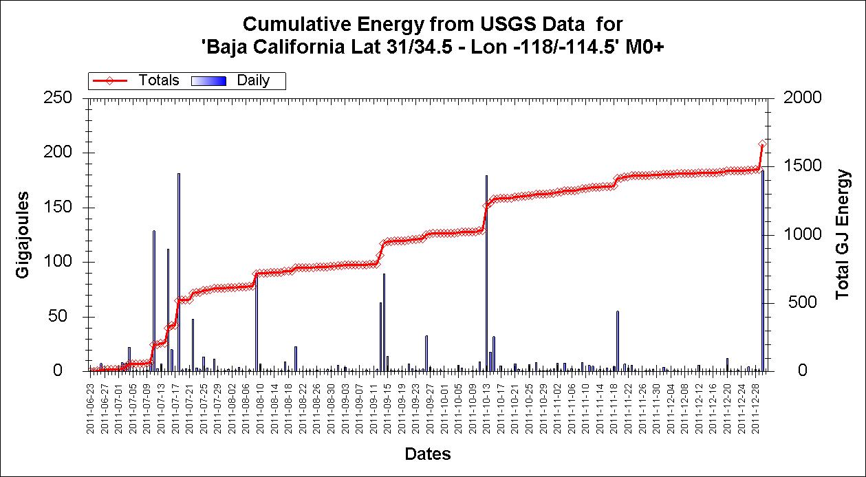
ALERT: This are is becoming unstable
quakes.globalincidentmap.com...
Friday December 30 2011, 16:32:43 UTC Baja California, Mexico 2.8 28.5 USGS Feed
Friday December 30 2011, 15:55:54 UTC Baja California, Mexico 3.0 21.1 USGS Feed
Friday December 30 2011, 15:50:11 UTC Baja California, Mexico 3.2 12.3 USGS Feed
Friday December 30 2011, 15:34:29 UTC Baja California, Mexico 4.3 29.4 USGS Feed
Also activity at the west coast is up
earthquake.usgs.gov...
Magnitude 3.2 - WESTERN MONTANA
2011 December 30 16:09:32 UTC
edit on 4/5/2011 by dreamfox1 because: info
reply to post by UtahRosebud
More so with mine as well except the reason they are giving is nonsense. Landslides do not remove materials from the faults, they redistribute them and landslides are relatively small fry in terms of mass/weight.
What does have an effect is the change in air mass (despite what TA thinks ) and this is an active area of research. Millions of tons of pressure change in short periods as a tropical storm/hurricane approaches and there is a measurable effect.
More research grants are needed to pursue both avenues however
ETA: Happy New Year to you and yours and all the best in 2012 as well.
edit on 30/12/2011 by PuterMan because: (no reason given)
Magnitude 5.2
Date-Time
Tuesday, December 27, 2011 at 18:32:51 UTC
Tuesday, December 27, 2011 at 07:32:51 PM at epicenter
Location 52.874°S, 10.489°E
Depth 11 km (6.8 miles)
Region SOUTHWEST OF AFRICA
Distances 502 km (311 miles) ENE of Bouvet Island
1995 km (1239 miles) N of Novolazarevskaya, Antarctica
2198 km (1365 miles) SSW of Cape Town, South Africa
2962 km (1840 miles) SSW of MASERU, Lesotho
Location Uncertainty horizontal +/- 19.4 km (12.1 miles); depth +/- 5.1 km (3.2 miles)
Parameters NST= 56, Nph= 56, Dmin=>999 km, Rmss=0.89 sec, Gp= 65°,
M-type=body wave magnitude (Mb), Version=7
Source
Magnitude: USGS NEIC (WDCS-D)
Location: USGS NEIC (WDCS-D)
Event ID usc0007ddt
USGS
This one just popped up - three days after the event. Interesting location even if not very big.
Date/Time UTC,Latitude,Longitude,Magnitude,Depth(Km),Location
2011-12-27 18:32:51, -52.873, 10.488, 5.2, 11.0, S.West Of Africa
2011-12-23 19:12:33, -52.129, 28.014, 5.9, 9.8, South Of Africa
I think the bottom of the world is about to fall off. ( in case anyone thinks I am serious.) There seems to be several around that big crack that runs all the way round!
edit on 30/12/2011 by PuterMan because: (no reason given)
you shouldn't have said that about the bottom of the world PM..seems NZ has been shaking today...this being the latest....they seem to have been
climbing all day. I really, really hope and pray that this is not leading up to history repeating itself down there.
Magnitude M 5.3
Region SOUTH ISLAND OF NEW ZEALAND
Date time 2011-12-31 00:44:46.0 UTC
Location 43.48 S ; 172.82 E
Depth 10 km
Distances 16 km E Christchurch (pop 363,926 ; local time 13:44:46.5 2011-12-31)
17 km SE Kaiapoi (pop 10,837 ; local time 13:44:46.5 2011-12-31)
Source parameters provided by another agency
EMSC
Rainbows
Jane
That 5.3 was only 11k's away, but no damage. Still a bit nerve racking to say the least!
In today's paper they're saying that there's a possibility of a 7+ in the area in the next 12 months
Honestly, a 7+ will reek absolute HAVOC given the damage that a 6.3 has done so far...praying that the Alpine fault (possible 8+) stays quiet for the next 1000 years or so!
In today's paper they're saying that there's a possibility of a 7+ in the area in the next 12 months
Honestly, a 7+ will reek absolute HAVOC given the damage that a 6.3 has done so far...praying that the Alpine fault (possible 8+) stays quiet for the next 1000 years or so!
edit on 30-12-2011 by SpaceJockey1 because: (no reason given)
I think there may be a mistake on the USGS list, they have
possibly transposed the New Guinea quake into the Christchurch one.
Its very rare that USGS are higher than Geonet, and Geonet have 4.8.
Also the SNZO trace on the 00:00:00 line is too early for the time of the Christchurch event at 00:44:47
maybe
Its very rare that USGS are higher than Geonet, and Geonet have 4.8.
Also the SNZO trace on the 00:00:00 line is too early for the time of the Christchurch event at 00:44:47
maybe
edit on 30-12-2011 by muzzy because: (no reason given)
Magnitude
3.5
Date-Time
Saturday, December 31, 2011 at 08:07:18 UTC
Saturday, December 31, 2011 at 02:07:18 AM at epicenter
Time of Earthquake in other Time Zones
Location
35.435°N, 96.569°W
Depth
5 km (3.1 miles)
Region
OKLAHOMA
Distances
34 km (21 miles) ENE of Shawnee, Oklahoma
58 km (36 miles) WSW of Okmulgee, Oklahoma
74 km (45 miles) N of Ada, Oklahoma
86 km (53 miles) E of OKLAHOMA CITY, Oklahoma
Location Uncertainty
horizontal +/- 6.8 km (4.2 miles); depth +/- 2.6 km (1.6 miles)
Parameters
NST= 19, Nph= 38, Dmin=14.5 km, Rmss=1.2 sec, Gp= 94°,
M-type="Nuttli" surface wave magnitude (mbLg), Version=6
Source
Magnitude: USGS NEIC (WDCS-D)
Location: USGS NEIC (WDCS-D)
Event ID
usc0007f2d
earthquake.usgs.gov...
new topics
-
What is the white pill?
Philosophy and Metaphysics: 57 minutes ago -
Mike Pinder The Moody Blues R.I.P.
Music: 1 hours ago -
Putin, Russia and the Great Architects of the Universe
ATS Skunk Works: 4 hours ago -
A Warning to America: 25 Ways the US is Being Destroyed
New World Order: 9 hours ago
top topics
-
President BIDEN's FBI Raided Donald Trump's Florida Home for OBAMA-NORTH KOREA Documents.
Political Conspiracies: 14 hours ago, 33 flags -
A Warning to America: 25 Ways the US is Being Destroyed
New World Order: 9 hours ago, 18 flags -
Is AI Better Than the Hollywood Elite?
Movies: 16 hours ago, 4 flags -
Mike Pinder The Moody Blues R.I.P.
Music: 1 hours ago, 4 flags -
What is the white pill?
Philosophy and Metaphysics: 57 minutes ago, 4 flags -
Putin, Russia and the Great Architects of the Universe
ATS Skunk Works: 4 hours ago, 2 flags -
Maestro Benedetto
Literature: 16 hours ago, 1 flags
active topics
-
One Flame Throwing Robot Dog for Christmas Please!
Weaponry • 11 • : Therealbeverage -
Gaza Terrorists Attack US Humanitarian Pier During Construction
Middle East Issues • 65 • : CarlLaFong -
Ditching physical money
History • 21 • : SprocketUK -
What is the white pill?
Philosophy and Metaphysics • 3 • : watchitburn -
Graham Hancock being proven right all along about ancient humans in America.
Ancient & Lost Civilizations • 106 • : JonnyC555 -
President BIDEN's FBI Raided Donald Trump's Florida Home for OBAMA-NORTH KOREA Documents.
Political Conspiracies • 29 • : MetalThunder -
Putin, Russia and the Great Architects of the Universe
ATS Skunk Works • 17 • : BrotherKinsMan -
Massachusetts Drag Queen Leads Young Kids in Free Palestine Chant
Social Issues and Civil Unrest • 18 • : ToneD -
Mood Music Part VI
Music • 3109 • : TheWoker -
Candidate TRUMP Now Has Crazy Judge JUAN MERCHAN After Him - The Stormy Daniels Hush-Money Case.
Political Conspiracies • 791 • : matafuchs