It looks like you're using an Ad Blocker.
Please white-list or disable AboveTopSecret.com in your ad-blocking tool.
Thank you.
Some features of ATS will be disabled while you continue to use an ad-blocker.

Quake Watch 2011
page: 407share:
"It is my goal here at MUZ ( not on the IRIS network, but it fits ) to produce an interactive map and a list of earthquakes each day within 24
hours, every day for New Zealand."
23rd Dec 2011 was a tough one, so many distractions, lots of quake events needing cross referencing and adding felt reports etc and the sun was shining too.
but here it is FWIW
interactive map of Christchurch (Pegusus Bay) earthquakes 23rd Dec 2011
and the List
Merry Christmas everyone at ATS
Damit MUZ is already taken
MUZ BUL -18.995 32.6267 0 Mutare (Umtali), Bulgaria
23rd Dec 2011 was a tough one, so many distractions, lots of quake events needing cross referencing and adding felt reports etc and the sun was shining too.
but here it is FWIW
interactive map of Christchurch (Pegusus Bay) earthquakes 23rd Dec 2011
and the List
Merry Christmas everyone at ATS
edit on 24-12-2011 by muzzy because: (no reason given)
Damit MUZ is already taken
MUZ BUL -18.995 32.6267 0 Mutare (Umtali), Bulgaria
edit on 24-12-2011 by muzzy because: (no reason given)
Father Christmas just crashed in the North Pole!
Magnitude mb 4.7
Region SVALBARD REGION
Date time 2011-12-24 22:39:07.2 UTC
Location 77.54 N ; 7.40 E
Depth 10 km
Distances 1239 km NW Murmansk (pop 319,263 ; local time 01:39:07.2 2011-12-25)
944 km NW Tromsø (pop 52,436 ; local time 23:39:07.2 2011-12-24)
170 km W Barentsburg (pop 576 ; local time 23:39:07.2 2011-12-24)
Source parameters provided by another agency
www.emsc-csem.org...
Merry Christmas everyone....minus prezzies
Rainbows with a fairy on top
Jane
Here's where the updates are as Santa was the cause....no aftershocks expected!
www.abovetopsecret.com...
Rainbows with skiis...we need them now
Jane
www.abovetopsecret.com...
Rainbows with skiis...we need them now
Jane
Merry Christmas and Happy Holidays to all of you my friends! Stay safe xoxo
Originally posted by muzzy
65 aftershocks from Christchurch so far with 2 hrs to go to the end of the 24hrs.
just comparing this one with the Feb 22 and the June 13th quakes
All 3 had reasonably big foreshocksaftershocks to 24:00:00, 92* to 22:15:38
All 3 occured in the early afternoon local time
The first 2 had roughly the same number of aftershocks to the end of the day.
01:50:25 Feb 22 - 5.7 foreshock 1 hr 6 minutes prior 5.89 mainshock, later revised to 6.343, 95*
02:20:49 June 13 - 5.646 foreshock 1hr 19 minutes prior, mainshock 6.338, 91* aftershocks to 24:00:00, 89* to 22:14:21
02:18:04 Dec 23 - 5.85 foreshock 1 hr 10 minutes prior, mainshock 6.0 (preliminary) 65 aftershocks to 22:15:16
yesterdays magnitude may come back revised slightly higher, like the others did, but based on the number of aftershocks I'd be surprised if it was more than 6.2
unless there are 25 more in the next 2 hrs
* the numbers of Feb and June are from the preliminary data I downloaded the next day, and was revised later with many more aftershocks listed, but for this comparison you can't compare preliminary numbers with revised numbers.
I made a big error here, I was thinking the 5.85 at was the bigun and had been revised upwards.
In fact the bigun (6.3) happened 10 minutes before noon the NZDT and hense happened in the morning.
It was in the day before UTC time, thats how I missed it.
Thought I was onto something there, that all 3 had a 5ish foreshock giving 1.-1.5hrs warning of the bigger one ( a bit like the Edgecumbe quake of 1987).
Only the June and December ones did.
edit on 25-12-2011 by muzzy because: (no reason given)
Is this some kind of error/problem with the sensor?:
Data from station YAK (Yakutsk, Russia)
last updated at
Sun 12/25/11 20:48 MST (Mon 12/26/11 03:48 UTC)
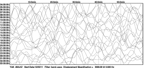
earthquake.usgs.gov...
Data from station YAK (Yakutsk, Russia)
last updated at
Sun 12/25/11 20:48 MST (Mon 12/26/11 03:48 UTC)
earthquake.usgs.gov...
edit on 12/25/2011 by this_is_who_we_are
because: typo
Magnitude 6.0
Date-Time
Monday, December 26, 2011 at 04:48:08 UTC
Monday, December 26, 2011 at 06:48:08 PM at epicenter
Location 16.155°S, 173.799°W
Depth 78.6 km (48.8 miles)
Region TONGA
Distances 28 km (17 miles) SSW of Hihifo, Tonga
272 km (169 miles) N of Neiafu, Tonga
346 km (214 miles) SW of APIA, Samoa
2552 km (1585 miles) NNE of Auckland, New Zealand
Location Uncertainty horizontal +/- 14.5 km (9.0 miles); depth +/- 5.9 km (3.7 miles)
Parameters NST=511, Nph=521, Dmin=330.6 km, Rmss=0.88 sec, Gp= 40°,
M-type=teleseismic moment magnitude (Mw), Version=9
Source
Magnitude: USGS NEIC (WDCS-D)
Location: USGS NEIC (WDCS-D)
Event ID usc0007cwg
earthquake.usgs.gov...
mb = 5.8 (371) ML = 5.9 ( 2)
IRIS AFI Samoa graph
LISS AFI Samoa
reply to post by ericblair4891
Interesting video for the masses. :shk: Sigh, yet another offering by men in white coats guessing.
Let me pose a question. Several times in the video they make reference to the fact that the shear wave they were looking for can only pass through solid material. Also often in the same sentence they make reference to the fact that the outer core is liquid, almost of the viscosity of water.
Despite this statement she looks for shear waves that cannot pass through the liquid portion in the 'solid' interior where they cannot go without passing through the liquid? (At least not intact)
Turning to Wikipedia for a moment we find this (which was my understanding of the theory)
en.wikipedia.org...
Yeah right! The only problem that I have will this is that at no time can the S wave in the 'solid' core actually be seen AS an S wave. It is in fact theory and not provable, although the men in white coats would have you believe otherwise mainly because they incapable for the most part of dealing in logic.
Now don't you find that rather strange that the ball of metal in our core is the same temperature as the plamsa of the sun?
Yes, there there, dream up some wonderful theories - after all you might be right. Then again however you might not!
It is one possible explanation, however it is not the only one.
Now let me see, where else do we find this behaviour? Oh silly me, yes the Sun.
P erhaps some time in the future scientists will
L earn that maybe the core of this planet is not molten/solid iron but
A n electrical field, a plasma exactly the same as the
S un and not related to
M olten metal in
A ny way.
...with the fantasies of scientists fiction...
Interesting video for the masses. :shk: Sigh, yet another offering by men in white coats guessing.
Let me pose a question. Several times in the video they make reference to the fact that the shear wave they were looking for can only pass through solid material. Also often in the same sentence they make reference to the fact that the outer core is liquid, almost of the viscosity of water.
Despite this statement she looks for shear waves that cannot pass through the liquid portion in the 'solid' interior where they cannot go without passing through the liquid? (At least not intact)
Turning to Wikipedia for a moment we find this (which was my understanding of the theory)
Unlike the P-wave, the S-wave cannot travel through the molten outer core of the Earth, and this causes a shadow zone for S-waves opposite to where they originate. They can still appear in the solid inner core: when a P-wave strikes the boundary of molten and solid cores, called the Lehmann discontinuity, S-waves will then propagate in the solid medium. And when the S-waves hit the boundary again they will in turn create P-waves. This property allows seismologists to determine the nature of the inner core
en.wikipedia.org...
Yeah right! The only problem that I have will this is that at no time can the S wave in the 'solid' core actually be seen AS an S wave. It is in fact theory and not provable, although the men in white coats would have you believe otherwise mainly because they incapable for the most part of dealing in logic.
...a temperature found at the core of the earth and the surface of the sun.....
Now don't you find that rather strange that the ball of metal in our core is the same temperature as the plamsa of the sun?
...contains a memory of what happened in the history of the earth...
...bashing together objects the size of Mars...
Yes, there there, dream up some wonderful theories - after all you might be right. Then again however you might not!
...as the heat flows from the inner to the outer core it creates convection and this creates the magnetic field...
It is one possible explanation, however it is not the only one.
...they found many places where there was opposite polarity....reach a tipping point and flip...
Now let me see, where else do we find this behaviour? Oh silly me, yes the Sun.
P erhaps some time in the future scientists will
L earn that maybe the core of this planet is not molten/solid iron but
A n electrical field, a plasma exactly the same as the
S un and not related to
M olten metal in
A ny way.
..to replace the fantasies of science fiction...
...with the fantasies of scientists fiction...
edit on 26/12/2011 by PuterMan because: To give a better sense of understanding to my ramblings
Just playing about with my new toy that I have about finished programming. This is the Stress sawtooth graph (my new term for these) for Alaska (FE
Region 1) for Magnitude 6.5 quakes upwards from 1900 to July 2011.
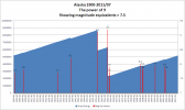
The graph displays magnitude equivalents for the stress relief in each month where that release exceeds the equivalent of a magnitude 7.5 earthquake.
Obviously because this is Alaska these are big numbers so each area has to be 'tailored' to suit. What I find fascinating about these is as clearly defined here the difference between the energy of the quakes. See the 8.2? That makes only a TINY DENT in the stress climbing upwards by comparison to the equivalents of Mag 9+
Statistically it might be reasonable to suggest that since the level at 1900 is almost exactly the same as the level now ** that stress that built up in the following 60 years may take the same period again. If that was the case then it could be a further 60 years (2070) before any quake of 9.0+ magnitude occurs in Alaska.
I have no idea how this pans out on the ground at present as this is only the second one I have looked at but there is probably some statistical validity. I doubt if the patterns of stress will change significantly in our fleeting time on earth, but I would not project this 10,000 years into the future!
** It is impossible to define an accurate level of stress at the 'start' of the graph. I have made an assumption in this case that the starting stress in built up energy is the equivalent of the largest release in the century * 1.3 generally.
Sometimes this is not going to be right. This graph used the following parameters (All Terajoules of energy)
TotalEnergy, PeriodicEnergy, MaxPeriod, MinPeriod
7,638,224, 5,683, 3,983,138, 0
The periodic energy is simply the maximum energy in the complete graph divided by the number of periods on the assumption that stress increase is reasonably constant. The MaxPeriod value is the largest value for any one period and I will leave you to guess what the MinPeriod might be
Which ever value I select for the start (and 1.3 has proved OK so far) the stress after relief must not fall below zero. Should that occur then the starting point has to be increased until the negatives vanish.
Enough of boring you!!!!
edit on 26/12/2011 by PuterMan because: Spelling and grammar :bnghd:
I'm in the books.
source(earthquake.usgs.gov...
TextMagnitude 5.6 Date-Time Monday, December 26, 2011 at 16:12:36 UTC Tuesday, December 27, 2011 at 03:12:36 AM at epicenter Time of Earthquake in other Time Zones Location 19.151°S, 168.686°E Depth 69.9 km (43.4 miles) Region VANUATU Distances 75 km (46 miles) NW of Isangel, Tanna, Vanuatu 161 km (100 miles) SSE of PORT-VILA, Efate, Vanuatu 278 km (172 miles) NNE of Tadine, Loyalty Islands, New Caledonia 1848 km (1148 miles) ENE of BRISBANE, Queensland, Australia Location Uncertainty horizontal +/- 16 km (9.9 miles); depth +/- 4.9 km (3.0 miles) Parameters NST=259, Nph=259, Dmin=399.6 km, Rmss=0.69 sec, Gp= 83°, M-type=body wave magnitude (Mb), Version=7 Source Magnitude: USGS NEIC (WDCS-D) Location: USGS NEIC (WDCS-D) Event ID usc0007d1f
Oops, didn't spot muzzy posted the Tonga quake.
edit on 27/12/2011 by PuterMan because: (no reason given)
TEPCO dissatisfied with panel's view of severe accident measures
(Mainichi Japan) December 27, 2011
mdn.mainichi.jp/mdnnews/news/20111227p2g00m0dm114000c.html
(Mainichi Japan) December 27, 2011
mdn.mainichi.jp/mdnnews/news/20111227p2g00m0dm114000c.html
TOKYO (Kyodo) -- Tokyo Electric Power Co. showed dissatisfaction Tuesday with a view suggested in an investigation report on the nuclear accident at the Fukushima Daiichi power plant that the utility should have taken precautionary measures to deal with severe nuclear accidents triggered by tsunami.
"It is not exactly right to say that we should have done so before March 11 (when the plant was hit by a huge earthquake and tsunami), although in hindsight the steps we had taken were not sufficient," a TEPCO official told a press conference, a day after a government panel released an interim report on its investigation.
Although TEPCO came up with a study in 2008 that tsunami over 10 meters high may hit the plant, the company justified its decision not to take immediate action because the figure was based on a "hypothetical calculation which did not have any scientific basis."
(...)
6.9 magnitude quake hits Russia
www.worldbulletin.net...
www.worldbulletin.net...
An earthquake of 6.9 magnitude hit southeastern Russia near the border with Mongolia on Tuesday, the U.S. Geological Survey said.
An earthquake of 6.9 magnitude hit southeastern Russia near the border with Mongolia on Tuesday, the U.S. Geological Survey said.
The epicenter of the quake was 28 miles (45 km) deep and was about 57 miles (92 km) northeast of Kyzyl, Russia, USGS said.
Reuters
Earthquake Details
This event has been reviewed by a seismologist.
Magnitude
6.6
Date-Time
Tuesday, December 27, 2011 at 15:21:56 UTC
Tuesday, December 27, 2011 at 10:21:56 PM at epicenter
Location
51.858°N, 95.825°E
Depth
6.9 km (4.3 miles)
Region
SOUTHWESTERN SIBERIA, RUSSIA
Distances
96 km (59 miles) E of Kyzyl, Russia
336 km (208 miles) NE of Ulaangom, Mongolia
361 km (224 miles) ESE of Abakan, Russia
3744 km (2326 miles) ENE of MOSCOW, Russia
Location Uncertainty
horizontal +/- 14.9 km (9.3 miles); depth +/- 6.8 km (4.2 miles)
Parameters
NST=227, Nph=227, Dmin=541 km, Rmss=0.82 sec, Gp= 36°,
M-type=teleseismic moment magnitude (Mw), Version=7
Source
Magnitude: USGS NEIC (WDCS-D)
Location: USGS NEIC (WDCS-D)
Event ID
usc0007dax
earthquake.usgs.gov...
edit on 12/27/2011 by this_is_who_we_are because: usgs data and
link
reply to post by this_is_who_we_are
You are very quick .
Anyway, looking at the history of the area...it moves some at times, but this big?
Hmmm
neic.usgs.gov...
You are very quick .
Anyway, looking at the history of the area...it moves some at times, but this big?
Hmmm
neic.usgs.gov...
Why does the Russian geogical service have it at 45km deep, while the USGS has it at 6.9km deep? Funny... the USGS depth is the same as the original
6.9 mag report from Reuters.
en.ria.ru/russia/20111227/170521954.html
AFP
www.dailystar.com.lb/News/International/2011/Dec-27/158064-69-magnitude-quake-hits-southeastern-russia-usgs.ashx
www.itar-tass.com/en/c32/307656.html
(...)
“Everything is all right. Our dispatchers work round the clock and they did not receive any calls on any destruction,” the spokesman said.
One of the local citizens residing on the 9th floor of a multi-storey residential building said everything was shaking so intense that the wardrobes in his apartment were about to fall down.
(...)
The ministry’s spokesman also said that local residents were warned about the possibility of aftershocks and were advised to leave their homes.
A spokesman for MRSK Siberia power grid company said that power supplies in the region were not damaged by the quake.
AFP
www.dailystar.com.lb/News/International/2011/Dec-27/158064-69-magnitude-quake-hits-southeastern-russia-usgs.ashx
(...)
The Russian emergencies ministry confirmed that a strong earthquake hit Tyva.
"According to preliminary information, there are no casualties or destruction," a spokesman for the Siberian branch of the emergencies ministry, told AFP. He declined further details.
The ITAR-TASS news agencies said residents of the larger Siberian cities of Krasnoyarsk and Abakan, hundreds of kilometers from Kyzyl, had reported feeling tremors but there were no reports of damage there.
(...)
www.itar-tass.com/en/c32/307656.html
KRASNOYARSK, December 27 (Itar-Tass) — Krasnoyarsk and Abakan reported a powerful tremor at 11:37 p.m. (7:37 p.m. Moscow time) on Tuesday. Furniture moved and window glass vibrated.
The Siberian regional center of the Emergency Situations Ministry is evaluating the situation.
(...)
new topics
-
Hate makes for strange bedfellows
US Political Madness: 33 minutes ago -
Who guards the guards
US Political Madness: 3 hours ago -
Has Tesla manipulated data logs to cover up auto pilot crash?
Automotive Discussion: 5 hours ago -
whistleblower Captain Bill Uhouse on the Kingman UFO recovery
Aliens and UFOs: 10 hours ago
top topics
-
Lawsuit Seeks to ‘Ban the Jab’ in Florida
Diseases and Pandemics: 17 hours ago, 22 flags -
CIA botched its handling of sexual assault allegations, House intel report says
Breaking Alternative News: 15 hours ago, 10 flags -
whistleblower Captain Bill Uhouse on the Kingman UFO recovery
Aliens and UFOs: 10 hours ago, 10 flags -
Who guards the guards
US Political Madness: 3 hours ago, 6 flags -
Deadpool and Wolverine
Movies: 13 hours ago, 4 flags -
1980s Arcade
General Chit Chat: 12 hours ago, 4 flags -
Teenager makes chess history becoming the youngest challenger for the world championship crown
Other Current Events: 14 hours ago, 3 flags -
Hate makes for strange bedfellows
US Political Madness: 33 minutes ago, 2 flags -
Has Tesla manipulated data logs to cover up auto pilot crash?
Automotive Discussion: 5 hours ago, 1 flags
active topics
-
1980s Arcade
General Chit Chat • 10 • : McUrnsalso -
New whistleblower Jason Sands speaks on Twitter Spaces last night.
Aliens and UFOs • 41 • : baablacksheep1 -
whistleblower Captain Bill Uhouse on the Kingman UFO recovery
Aliens and UFOs • 11 • : baablacksheep1 -
IDF Intel Chief Resigns Over Hamas attack
Middle East Issues • 37 • : TheWoker -
Candidate TRUMP Now Has Crazy Judge JUAN MERCHAN After Him - The Stormy Daniels Hush-Money Case.
Political Conspiracies • 646 • : Threadbarer -
"We're All Hamas" Heard at Columbia University Protests
Social Issues and Civil Unrest • 216 • : Vermilion -
MULTIPLE SKYMASTER MESSAGES GOING OUT
World War Three • 93 • : Oldcarpy2 -
Republican Voters Against Trump
2024 Elections • 281 • : Justoneman -
Hate makes for strange bedfellows
US Political Madness • 1 • : Edumakated -
Who guards the guards
US Political Madness • 1 • : JAY1980