It looks like you're using an Ad Blocker.
Please white-list or disable AboveTopSecret.com in your ad-blocking tool.
Thank you.
Some features of ATS will be disabled while you continue to use an ad-blocker.

Volcano watch 2011
page: 32share:
Don't know if anyone posted the page link prior to the last few pages but
heres the link
to IGN CHIE -El Heirro
just change the day (twice in the address) ie 29 to 30 etc, and you'll get the next siesmo page
the nearest IRIS Quak siesmo is fMACI.IU. on Tenerife but its picking up the quakes above 3.5 quite nicely on BHZchannel
edit: this HNE channel might be better, went nuts between 1400 and 1600 like the CHIE so might be more sensitive
change HNE to HNN or HNZ (channels) and much the same look
edit on 29-9-2011 by muzzy because:
reply to post by muzzy
Ahhhhhhh . . . thanks.
Have you watched the moving 4D video of the color coded quakes on that Canary island?
I think it's a splendid graphic representation . . .
Yet, as a layman, I don't know much what to make of it. It sure seems like there's a ton of quakes--though low in magnitude--and one might think that so many quakes have to have some sort of consequence or result . . . or be the result of something slightly to moderately significant.
I think my notion of the North--South movement of the swarms . . . over time . . . was more in keeping with a mountain that was essentially a rock pile or frature-able into a rock pile. I don't know that it would at all apply to a liquid magma filled funnel. But then so many quakes would not be coming from a blob of liquid, would they?
They might arise from the magma pressuring surrounding rock volumes, though, it seems to me???
Interesting anyway.
Thanks for your kind reply.
reply to post by BO XIAN
yeah I posted the link
I think the earthquakes are caused by the magma finding weak fractures and filling them, then the fracture expands causing the rocks to break (ie earthquake). Imagine some TNT going off in a Quarry.
Add the whole lot up, 8713 at the latest count over 2 months, and it might be no more energy released than a single low Mag 5 earthquake (don't know, haven't calculated that yet)
reply to post by muzzy
Ahhhh. Sorry, I don't keep track of details like that well.
Thanks for posting that video link.
I watched it 2-4 times.
If you do that calculation, I hope i catch it. That would be interesting.
Though you send me pondering along my previous lines again . . . It seems to me . . .
that LOTS of quakes advancing North to South . . . fracturing as they go . . . particularly on some sort of slope trajectory . . . WOULD be loosening things up and cocking things for some sort of eventual landslide.
Is there anything inherently or solidly wrong with such a conjecture?
What is strange is that El Hierro quakes are going deeper and deeper. 10 days ago most of quakes happened in depth of 12 kilometers, now they are at
14 kilometers, but they are increasing. Trend seem to be going up again, too early to say for sure.
It has been long time since El Hierro erupted last time, 1792. Before that it erupted in 1692 and 1677. It isn't very active volcano.
www.volcanolive.com...
It has been long time since El Hierro erupted last time, 1792. Before that it erupted in 1692 and 1677. It isn't very active volcano.
www.volcanolive.com...
reply to post by BO XIAN
thats OK
Based on data starting
19/07/2011 08:59:50
there have been
8060 less than mag 2.0
of those
2888 less than mag 1.0
69 less than mag 0.0 ( one at mag -2)
and
732 mag 2.0 to mag 2.9
42 mag 3.0 to mag 3.8
Total Energy released to 29/9/2011 11:59:48.9 is 126.24358 tons of TNT equal to just a single Mag 4.615 earthquake
this is starting to look like westcoast's Pacific Northwest "Tremors" where the clusters move up and down the coast over a long period.
What might really be happening in Washington State
Cascadia Interactive Tremor Map
Its too bad the pnsn don't give magnitudes on that so we could compare whats happening with Hierro
Thinking back to the eruptions in Chile and in Dufur earlier this year, where there were multiple Mag 4 earthquakes just prior to the eruptions, there are no definite signs as yet of an imminent eruption at Hierro (that is if it performs to the eruptive pattern)
reply to post by muzzy
Hmmmmmmmm Interesting. Thx.
Why do you think the officials there are saying there's a 99% chance of an eruption within a short time?
Sounds like they've already taken serious steps for an evacuation.
Hmmmmmmmm Interesting. Thx.
Why do you think the officials there are saying there's a 99% chance of an eruption within a short time?
Sounds like they've already taken serious steps for an evacuation.
reply to post by BO XIAN
I'd say because they are covering thier arses.
also being an island there isn't many places to escape to
What areas are being evacuated? the last I read they were just evacuating where there were possibilities of landslides.
FWIW I have started on the animated GIF of the sequence of quakes from 19/08/2011 to 30/09/2011 (today UTC), it is taking average 1:05 minutes to break out each day from the data and create an Excel csv file then 1:22 minutes to run each one through GPS Visualiser and then snag the image and save it to file
Should take another 2.12 hours at this rate to complete then an hour or so to animate it
Probably be ready in the early afternoon with the usual expected interuptions.
reply to post by PuterMan
yes it has
while your here, any ideas what the interference might be on fMACI.IU H channels, seems to be every day at 0000 hours, 1300-1600hrs and again at 2300hrs
I wondered if it might be planes landing at Tenerife Airport, but the airport runway is 31km north of the MACI station
www.iris.edu...
www.iris.edu...
www.iris.edu...
www.iris.edu...
prior to day 270 the early and late signals moved to 0200 and 1700 hours
www.iris.edu...
day 264 was at 0000 and 1800hours witht he 1300-1600hrs consistsnt throughout
www.iris.edu...
can't see anything man made on GE at the station location 28.25, -16.51
www.theweathernetwork.com...&stormfile=mount_etna_erupts_in_a_spect_290911?ref=ccbox_weather_topstories
www.youtube.com...#!
www.youtube.com...#!
got that animated gif done (late afternoon now) I had to take a cat nap about 2pm
fast version 8:48 seconds
slow version 1 minute 24 seconds
Both files are 3.88 MB so may take a while to start (maybe not)
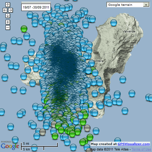
I just did each day seperately in sequence, to accumulate them into a massive lump at the end would have created too big of a file size. 74 images
Near the end you can really see that dramatic shift south and off shore, otherwise the daily clusters shift about in an almost hypnotic pattern, expanding and contracting as well
I've left the programme open on my laptop so hopefully I can add more days to it in the next few days.
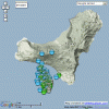
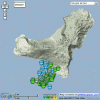
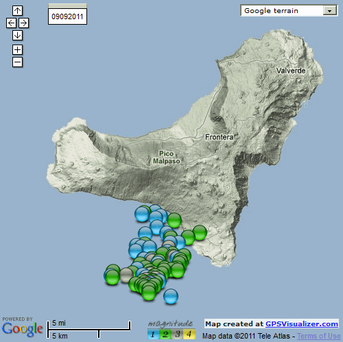
FWIW heres an image of what the the massive clump at the end looked like anyway (all 8842 quakes)
fast version 8:48 seconds
slow version 1 minute 24 seconds
Both files are 3.88 MB so may take a while to start (maybe not)
I just did each day seperately in sequence, to accumulate them into a massive lump at the end would have created too big of a file size. 74 images
Near the end you can really see that dramatic shift south and off shore, otherwise the daily clusters shift about in an almost hypnotic pattern, expanding and contracting as well
I've left the programme open on my laptop so hopefully I can add more days to it in the next few days.
FWIW heres an image of what the the massive clump at the end looked like anyway (all 8842 quakes)
reply to post by muzzy
WOW. WONDERFUL WORK. THX THX.
A FREEPER just notified me by private message that he'd just recently been to the Canary Islands and was convinced that few folks have any idea what 500 cubic MILES falling into the sea could result in, on the USA's East coast.
It's hard for a layman like me to discern what the probabilities are.
Your animations will be very helpful in visualizing the realities involved.
thanks for the encouragment
I only made one mistake on that, the image I loaded for 19082011 was actually the image for 19072011
I doubt anyone would have noticed on the fast version, but you could see it on the slow version.
I have corrected that (may have to delete cookies if you use Firefox or IE to see the new version).
I doubt this cumulative equvalent of a Mag 4.6 would be enough to cause a catastrophic landslide, maybe a Mag 7 would
edit on 1-10-2011 by
muzzy because: (no reason given)
Originally posted by muzzy
I doubt this cumulative equvalent of a Mag 4.6 would be enough to cause a catastrophic landslide, maybe a Mag 7 wouldedit on 1-10-2011 by muzzy because: (no reason given)
THANKS BIG.
Someone on another site is pontificating that the energy would dissipate too much before it reached the Eastern Seaboard of the USA.
Seems to me that's nonsense though, of course, dependent on the size and speed of a landslide.
How many cubic miles of landslide how fast would need to occur to result in say a 50 ft tsunami over Florida etc?
--100 ft tsunami?
Some are saying the tsunami could be as high as 150 feet to even 200 feet.
I think the bloke on that other site has some flawed assumptions. The tsunami many hundreds? of years ago that traveled from Japan all the way across the larger Pacific to devastate the coast of California, Oregon, Washington, Canada etc. carried quite a large punch all the way across the Pacific!
Looks like things are heating up on Krakatoa too
"Anak Krakatau raised to highest alert status- quakes are now continous, warn officials
Posted on October 2, 2011 by The Extinction Protocol
October 2, 2011 – INDONESIA - Indonesian officials have raised the status of one of its most dangerous volcanoes, Anak Krakatau, to a “standby” or level IV- the highest level. The Center for Volcanology and Geological Hazard Mitigation (PVMBG), Surono said this is a rise in status that was set on Friday, September 30, 2011 evening at 24.00. The reason for the elevated status is because of the high-intensity level of earthquakes. Today, for example. “On October 2, 2011, at 00.00 until 12.00, there are 2745 recorded seismic events,” said Surono, when he was contacted by VIVAnews.com, Sunday, October 2, 2011. Earthquakes under Mount Anak Krakatau, Surono added, were even felt all along the island of Anak Krakatau. “The swarm of tremors are continuous and although small, 2 on the Richter scale, they are cause for concern because they are felt constantly,” he added. He explained, almost since 2007, Krakatau has been stirred by unrest. “In a moment, it stopped, and erupted in 2009. I think this mountain is always in danger of erupting,” he added. –Viva News (translated)"
theextinctionprotocol.wordpress.com...
Rainbows
Jane
Originally posted by angelchemuel
Looks like things are heating up on Krakatoa too
“On October 2, 2011, at 00.00 until 12.00, there are 2745 recorded seismic events,” said Surono
Rainbows
Jane
Hmmmmm I wonder where you could get those locations?
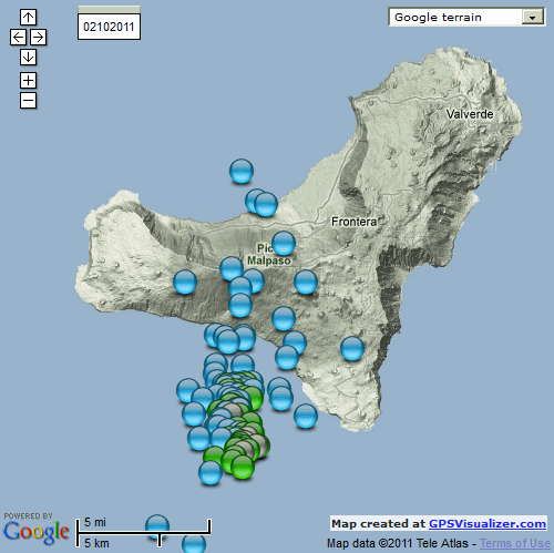
Hierro still pulsing offshore, more 3's now
01102011 - 116 events

02102011 - 102 events

source - www.ign.es...
01102011 - 116 events
02102011 - 102 events

source - www.ign.es...
edit on 3-10-2011 by muzzy because: (no reason given)
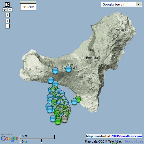
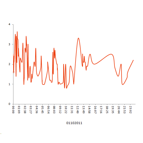
Hierro
03102011 - 98 events
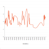
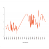
Note all but one below sea level, and the graph is back up at a higher level after a drop yesterday morning (UTC)
2 out of 3 graphs show a drop of in activity in the afternoon ( maybe just coincidence, would need to do more graphs to see if this is a trend)
I've put a magnitude key on the maps now, note the "4" , can't be far off now?
I have no idea what I'm doing with the graphs, just tried one out and it looked cool
if there is a long loop it means a gap in activity, if the line is all crunched together its intense short period tremors, 03102011 shows both of these nicely in the p.m. 1458 to 2153 just 5 events, then a rapid spurt of 16 events in 2 hrs near the end of the day
03102011 - 98 events

Note all but one below sea level, and the graph is back up at a higher level after a drop yesterday morning (UTC)
2 out of 3 graphs show a drop of in activity in the afternoon ( maybe just coincidence, would need to do more graphs to see if this is a trend)
I've put a magnitude key on the maps now, note the "4" , can't be far off now?
I have no idea what I'm doing with the graphs, just tried one out and it looked cool
if there is a long loop it means a gap in activity, if the line is all crunched together its intense short period tremors, 03102011 shows both of these nicely in the p.m. 1458 to 2153 just 5 events, then a rapid spurt of 16 events in 2 hrs near the end of the day
Just for you muzzy, in your neck of the woods!
hisz.rsoe.hu...
"GNS Science says the volcanic alert level at Ruapehu remains at 1, despite the temperature of the crater lake rising towards conditions typical for an eruption. Skiers on the Whakapapa ski field in the central North Island have reported smelling hydrogen sulphide gas in recent weeks. Volcanologist Brad Scott says this is because the temperature of the crater lake is cooler, which tends to produce more gas. The latest Volcanic Alert Bulletin says the lake's temperature on 29 September was 17.6 degrees Celsius. In March, the temperature peaked at 41 degrees Celsius. Mr Scott says the lake is heading towards a temperature where volcanic activity typically occurs, but doesn't always. Ruapehu is an active volcano and future eruptions may occur with little or no warning. The eruption detection system on the mountain functioned well during a test last week, he says."
Rainbows
Jane
new topics
-
James O’Keefe: I have evidence that exposes the CIA, and it’s on camera.
Whistle Blowers and Leaked Documents: 5 minutes ago -
Australian PM says the quiet part out loud - "free speech is a threat to democratic dicourse"...?!
New World Order: 50 minutes ago -
Ireland VS Globalists
Social Issues and Civil Unrest: 1 hours ago -
Biden "Happy To Debate Trump"
Mainstream News: 1 hours ago -
RAAF airbase in Roswell, New Mexico is on fire
Aliens and UFOs: 2 hours ago -
What is the white pill?
Philosophy and Metaphysics: 3 hours ago -
Mike Pinder The Moody Blues R.I.P.
Music: 4 hours ago -
Putin, Russia and the Great Architects of the Universe
ATS Skunk Works: 7 hours ago -
A Warning to America: 25 Ways the US is Being Destroyed
New World Order: 11 hours ago
top topics
-
President BIDEN's FBI Raided Donald Trump's Florida Home for OBAMA-NORTH KOREA Documents.
Political Conspiracies: 17 hours ago, 35 flags -
A Warning to America: 25 Ways the US is Being Destroyed
New World Order: 11 hours ago, 20 flags -
Mike Pinder The Moody Blues R.I.P.
Music: 4 hours ago, 7 flags -
What is the white pill?
Philosophy and Metaphysics: 3 hours ago, 5 flags -
Biden "Happy To Debate Trump"
Mainstream News: 1 hours ago, 5 flags -
Australian PM says the quiet part out loud - "free speech is a threat to democratic dicourse"...?!
New World Order: 50 minutes ago, 4 flags -
RAAF airbase in Roswell, New Mexico is on fire
Aliens and UFOs: 2 hours ago, 4 flags -
Putin, Russia and the Great Architects of the Universe
ATS Skunk Works: 7 hours ago, 3 flags -
Ireland VS Globalists
Social Issues and Civil Unrest: 1 hours ago, 2 flags -
James O’Keefe: I have evidence that exposes the CIA, and it’s on camera.
Whistle Blowers and Leaked Documents: 5 minutes ago, 0 flags
active topics
-
So this is what Hamas considers 'freedom fighting' ...
War On Terrorism • 265 • : YourFaceAgain -
-@TH3WH17ERABB17- -Q- ---TIME TO SHOW THE WORLD--- -Part- --44--
Dissecting Disinformation • 696 • : daskakik -
Biden "Happy To Debate Trump"
Mainstream News • 29 • : theatreboy -
James O’Keefe: I have evidence that exposes the CIA, and it’s on camera.
Whistle Blowers and Leaked Documents • 0 • : pianopraze -
University of Texas Instantly Shuts Down Anti Israel Protests
Education and Media • 284 • : cherokeetroy -
Supreme Court Oral Arguments 4.25.2024 - Are PRESIDENTS IMMUNE From Later Being Prosecuted.
Above Politics • 96 • : xuenchen -
Ireland VS Globalists
Social Issues and Civil Unrest • 6 • : TimBurr -
President BIDEN's FBI Raided Donald Trump's Florida Home for OBAMA-NORTH KOREA Documents.
Political Conspiracies • 32 • : network dude -
Massachusetts Drag Queen Leads Young Kids in Free Palestine Chant
Social Issues and Civil Unrest • 20 • : Oldcarpy2 -
Australian PM says the quiet part out loud - "free speech is a threat to democratic dicourse"...?!
New World Order • 2 • : ColeYounger2