It looks like you're using an Ad Blocker.
Please white-list or disable AboveTopSecret.com in your ad-blocking tool.
Thank you.
Some features of ATS will be disabled while you continue to use an ad-blocker.

Yellowstone: What if they are wrong?
page: 5share:
So I ran some numbers just to see if it was possible that the event was because of the Columbia quake:
I got the coordinates of both the Columbia quake and the YSB station sensor, and used a distance between coordinates calculator.
It's 5,387.12 km distance between the two points
divided by
8 km/s= 673.39 seconds
673.39 seconds (divide by 60) =
11.2 minutes rough estimated time (at 8 km/s average wave speed)
YSB shows the event arriving at 20:12 UTC
The event in Columbia occurred at about 19:48 UTC
The difference is about 24 minutes- more than twice the time it should have taken to arrive using an 8 km/s estimated P-wave travel speed. It would take using an average of 4 km/s wave speed to equal a 22.4 minute travel time. And even slower, like 3.8 km/sec to get to the actual observed arrival time of 24 minutes.
The other problem is that this quake registered strongest in mid Montana on Gee, and strongest at YSB station. And LWKY barely even registered it. And stations south of the Lake barely registered it. Given the location of those sensors, it would imply that the quake came from mid Montana or east or maybe north of the Lake Yellowstone somewhere.
Very strange, but possible I suppose if the average wave travel speed was in the 3 to 4 km/s range. But I just don't understand given all I saw on that one how it could have come from the south relative to YS.
Plus, are we going to register a mere 4.7 mag quake at 5,387.12 km away with a signature on all three channels showing dead even pretty much? Not likely, and that would not match other s-wave signatures from far away quakes I've seen. And there's one good reason right there to monitor all three channels and NOT discard any.
[edit on Tue Jan 13th 2009 by TrueAmerican]
Just a reminder of some of the earthquake activity at YS BEFORE these recent swarms. This is just from 1973 to 2002, with the two big quakes
added in (a 7.5 in 1959-the big red dot- and a 6.1 in 1975- the big pink dot). So add to this picture in your mind all the quakes since 2002 that
qualify in magnitude. And that's just in the last 50 years or so! A mere spec of dust in the earth history timeline.
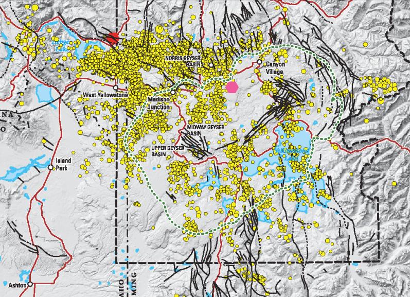
Brave are the souls at the USGS and other institutions that continually face the unknown in studying this, with the potential near elimination of the human species at stake. I am hoping Earthscope is successful in all phases of their venture. They are right every singly day that it does not erupt. And what more could one ask for? They are doing incredible work to help keep us safe.
But the above reality must be shown so all can see. And if you click on the image, you will see the whole thing.
[edit on Wed Jan 14th 2009 by TrueAmerican]
Mod Edit: Graphics must be under 680px wide. Scaled image. Right click and view image to see full size.
[edit on 1/21/2009 by Badge01]
I wish that last post was more readily available to more people out there. Especially the thousands of people that are overly paranoid about
Yellowstone erupting.....I know that deep down inside these people want Yellowstone to erupt because their lives are so sad and pathetic they either
need an end like this...or they want more meaning to their lives....and they feel like Armageddon has to happen.....otherwise all their worrying and
fear mungering was for nothing.
Sure I'm concerned about it, and I'm prepared for it....but I leave it at that. One of the joys of life is not knowing how it will end so you don't have to worry about it. Nature is so unpredictable...and so is life.
WOLFMAN has spoken
Sure I'm concerned about it, and I'm prepared for it....but I leave it at that. One of the joys of life is not knowing how it will end so you don't have to worry about it. Nature is so unpredictable...and so is life.
WOLFMAN has spoken
Where TA go? Would like to get your take on the EQ events on the 422630 charts (or non-eq events as they may be). I come home from work and look to
see the days latest analysis
Originally posted by rentingspace
Where TA go?
Oh I'm around. And usually signed on, but often away from the computer. Just easier to stay logged on.
Would like to get your take on the EQ events on the 422630 charts (or non-eq events as they may be).
Well, considering what I have been working on behind the scenes here, I find it very odd that you would register to this site just to come on here and ask me that question. It is your only post so far. Now don't get me wrong, we love new members, and welcome to ATS. It's just weird.
But you'll have to elaborate a bit please, as I don't understand the "422630 charts" question with no links provided or anything more.
I come home from work and look to see the days latest analysis
So then I'm curious as to why you have not registered sooner and offered your input over in the What's going on at Yellowstone thread or this one or any other? What is your opinion of the situation? You think it's going to blow?
lol I found this site beginning of this month when I was googling yellowstone due to the swarm activity. I saw the thread of "what if they are
wrong" and the "what is going on at yellowstone". I thought it was interesting and cool. Didn't even know ATS existed before that. I am an EE
so I gravitate towards intelligent posts that aren't too extreme and your post fit the bill. Since then, I have downloaded GEE (didn't even know
what that was a few weeks ago thanks for the new vice) and included it and ATS into my nightly after work news scan.
This thread happens to stay much more on topic than the "what is going on.." (www.abovetopsecret.com/forum/thread422630/pg389) though they are both interesting. I guess since my daughter passed away almost a year ago from leukemia that I also tend to gravitate towards doom and gloom kinda events. It wasn't this way before she passed and I was happy to go about my life in ignorant bliss to most of this but now I would rather be at ground zero.
Over on the "what is going on..." thread they show these pipe cleaner type of events on the LKWY monitors and I thought you might have some insight which is why I posted. I'm a newbie in this area so I haven't been posting since I don't have any insight into this. I don't even know the difference between the 3 types of GEE readings as of yet. Microns/sec I get at least .
So no I registered to post a "what do you think" because I find it interesting and filling my head with this stuff is less painful than thinking about my personal life clear across the country from Yellowstone. I did have a chance to take her there summer before last though she was too young I think to really remember it had she been cured. It was one of the three trips she got to take in her short life (one a year). Perhaps that link as well draws me in some strange way.
Sorry if I caused any concern.
Edit: seems that putting in http link breaks the rest of text or at least on my screen so trying to fix
[edit on 20-1-2009 by rentingspace]
[edit on 20-1-2009 by rentingspace]
Originally posted by BlueTriangle
I think it's kind of pointless to even prepare for the eminent Yellowstone eruption. Based on the reading I've done and several documentaries I've watched...an eruption will be a near extinction event. Anyone within a few hundred miles is dead quickly. The entire continental US will be under several feet of ash and is doomed. The entire world will experience nuclear winter and a good portion of the population will die off as a result.
There's no way to properly prepare for such an event short of evacuating the entire continent. That seems a little extreme to prepare for an event that could happen tomorrow...or 500,000 years from now.
I feel like I have to keep weighing in on another side of this. Lots of people are fond of talking like this, but the facts point to something else. The pattern at YS has shifted. The extinction level eruptions have been replaced by a different type of activity.
read this carefully:CVO Website
Renewed magmatic activity has produced voluminous lavas in the Yellowstone caldera since approximately 150 thousand years ago, perhaps even indicating a fourth volcanic cycle. Following emplacement of a large rhyolitic lava flow in the western ring-fracture zone, renewed uplift of the resurgent dome occurred, reflecting insurgence of magma into the caldera system. Since that time, voluminous rhyolitic lavas (several individual flows exceeding 50 cubic kilometers) have filled the central part of the caldera and overflowed its western rim. These lavas were emplaced in three major episodes at approximately 150 thousand years ago, 110 thousand years ago, and 70 thousand years ago, each time erupting from both the western and eastern sides of the western ring-fracture zone to form the Madison and Central plateaus, respectively. The aggregate volume of these lavas is approximately 1,000 cubic kilometers. Deformation, probably related to continued magmatic activity beneath the Yellowstone caldera, continues with caldera-wide uplift and subsidence at rates as high as 2 centimeters per year. .
We are more likely to see something on the level of Tambora. We will see major famine, significant loss of life, and major social impact , but not a extinction level event. On the other hand it may be considerably worse, but very unlikely 1000 cubic Km.
Major bads news, "Life ain't fun nomore", but not KYSGB
reply to post by rentingspace
Sorry to hear about her.
And you never did answer my question about what you meant by that chart you were talking about! I can't give you an opinion until you clarify that or provide a link. Just so you know, this site has an "auto url condense" feature. I think it's meant to keep the display width of posts consistent. So just copy a link, any link, and paste it into your post- the site takes care of the rest. Don't worry about what it looks like after you post, just make sure the url is right.
And no problem man, don't worry bout it. One way or the other, it may become clearer why I expressed that concern soon. I have an article pending that may explain some things- just waiting on TPTB.
Right now what we have is accelerated ground deformation, which has been increasing at a much faster rate in the last three years, since 2005. Something happened back in 2005 to instigate this, and to save my life I can't figure out what it was that happened.
But I suppose until the animals start acting weird, and dead fish start turning up all over the place, some would argue we have nothing to worry about. But technology has provided us with that much info, and that's probably a lot more info and warning than many previous civilizations had prior to eruption.
Thanks TA. I can't find that page with the lines that look like pipe cleaners. So I will throw out an uninformed opinion.
Ice shelves have/are melting which has allowed much more volumes of water to reside over the north and south poles. This has changed(ing) the distribution of weight on the tetonic plates most notably the North American plate. So like a lever the weight of the water is tipping the North American plate (very slightly) pushing down on the northern part of the plate changing the pressure primarily on the pacific and caribbean plates. This would be a secondary effect for increased activity in the ring of fire where subduction would be the primary. As the plate movements increase (mostly subduction aided by northern plate pressure), consider that conditions may be ripe at this point to actually allow for such small relative pressure to cause this to happen. Lets say that the pacific plate has created sufficient subduction to disrupt the core dynamo movement which accounts for a weakening magnetosphere. It would also potentially reduce pressure on some areas of the crust (say the extreme north) while increasing pressure in other areas (including hot spots). So the added northern plate pressure helps to speed subduction which in turn could actually allow for a greater effect of the original northern water pressure. This multiplying effect would stop once the plates equalized again but the north american plate elevation would be seen to increase in its' most southern points.
Any fracture or weak points (Yellowstone) in the crust would come under additional stress as there may be some separation of lower (older) plates and partially molten rock layers. This would cause a serious of small quakes precipitated from plate movement primarily while weakening any partial obstructions in the magma chimneys feeding more heat into the magma chamber beneath the caldera. This of course would cause a rise in the dome from the renewed energy surge and unfortunately the eventual crack that results in the dome failure or allows water intrusion if it continues.
Major Yellowstone eruptions, however, do not fall nicely into glacial and interglacial periods which means that water intrusion may be the much larger culprit for eroding the integrity of the dome cap or perhaps subduction of major plates triggering pole shifts can be equally exciting.
If this is closer to the mark then we would likely be 100s if not a few thousand years away from the big event with a huge caveat on two things....
1) Water intrusion alone could blow the top and it doesn't need any geological event to work its' magic but rather just time and chance cracks
2) Geological chance EQ precipitates a localized collapse of previously eroded rock.
At least I learned something tonight and probably made a geologist or two laugh their heads off at my 2 hours of research BS. But hey, TA did ask me to take a crack at it so there it is.
Originally posted by rentingspace
Thanks TA. I can't find that page with the lines that look like pipe cleaners. So I will throw out an uninformed opinion.
If you are referring to what I am thinking, I believe them to be coal mine blasts coming either from southern Montana or far east Wyoming. I have some info to back that up, contained in a small article pending with the site.
The rest of your post was a great read, and certainly food for thought. Thank you.
At least I learned something tonight and probably made a geologist or two laugh their heads off at my 2 hours of research BS. But hey, TA did ask me to take a crack at it so there it is.
I have no doubt they're all laughing at this thread too. I love Yellowstone geologists laughing. No prettier a sight. May they laugh at or with your children and theirs too.
So if those mining operations are being felt in YS then that makes me want to ask if that is such a good idea given the risk YS represents. Also, I
sure hope they aren't anywhere near the chimney.
Originally posted by rentingspace
So if those mining operations are being felt in YS then that makes me want to ask if that is such a good idea given the risk YS represents. Also, I sure hope they aren't anywhere near the chimney.
Well, let's be clear. SOME events are felt that far, not all. Again, gotta wait for article, but SO is extremely busy right now on more important things. So I have been informed, and shall we say my sources are pretty good.
Even so, you make a point. But any shocks being felt at the lake from those are still tiny. If the place hasn't blown up yet with hundreds of earthquakes in a week, I really doubt a mine blast from afar is going to make any difference or have much affect on the Yellowstone area directly.
But things like 6+ mag quakes as close as Alaska or bigger ones farther away were clearly pushing a lot more ground on lake area stations than any mine blast. Jeez, the s-waves from that massive 7+ a while back was pretty wild to see on GEE as they came in. Some of this increased seismic activity worldwide can present an additional threat to Yellowstone for sure. California seems to be going nuts. One big one there, and well, you know what I am saying.
Very good point and well taken. Though I can't say that the prospect of a larger (and inevitable) quake possibly triggering a Yellowstone EQ will
make me sleep better at night. One we have control over and well the other one we can only watch _javascript:icon(''). As long as we can all
watch and speculate then it is good _javascript:icon('')
To your point... Redoubt Raised to Orange
[edit on 25-1-2009 by rentingspace]
[edit on 25-1-2009 by rentingspace]
To your point... Redoubt Raised to Orange
[edit on 25-1-2009 by rentingspace]
[edit on 25-1-2009 by rentingspace]
reply to post by rentingspace
Yeah, so let's hope we never see that pattern at Yellowstone.
There's the beading so often talked about, along with a sustained tremor. Looks like eruption could be imminent.
Now obviously my concern here is not only for any area residents, but also that this is in southern Alaska. Meaning seismic activity there could affect Yellowstone if it is large enough. But Yellowstone has proven to be pretty stout- Thank God.
Even so, look at their webicorder from just yesterday:
www.avo.alaska.edu...
Does that appear much different from the webicorder graphs we saw of YS during the swarms? Sure doesn't to me, and that's the scary part. So in just one day it went to beading and sustained tremors? Lordy this stuff can fry nerves.
[edit on Sun Jan 25th 2009 by TrueAmerican]
Yeah, so let's hope we never see that pattern at Yellowstone.
There's the beading so often talked about, along with a sustained tremor. Looks like eruption could be imminent.
Information Statement
Over the past 48 hours, seismic activity at Redoubt Volcano has increased markedly. This has taken the form of periodic tremor bursts that are most visible on the two seismic stations closest to the summit. Beginning at 00:58 AKT (9:58 UTC) this morning, tremor became sustained and its amplitude increased markedly. AVO raised the Aviation Color Code to ORANGE and the Alert Level to WATCH this morning at 2:09 AKT (11:09 UTC).
This activity could be precursory to an eruption, perhaps within hours to days. A further increase in seismicity is expected to accompany an eruption. There is no indication that the volcano is currently erupting.
At this time, clouds obscure the volcano in satellite views, but NEXRAD weather radar data show no signs eruptive activity. AVO has received no recent observer reports. Staff are currently monitoring the volcano 24 hours a day.
AVO raised the Aviation Color Code to YELLOW and the Volcano Alert Level to ADVISORY on November 5, 2008, in response to increased emissions of SO2, H2S, and CO2; melting of snow and ice near the volcano’s summit; and a subtle increase in seismicity. These observations reflected a change in the volcano’s hydrothermal system, possibly associated with an influx of new magma beneath the volcano. It is also possible that the change was related to the development of a new pathway of heated fluids rising from magma intruded during the 1989-90 eruption.
Now obviously my concern here is not only for any area residents, but also that this is in southern Alaska. Meaning seismic activity there could affect Yellowstone if it is large enough. But Yellowstone has proven to be pretty stout- Thank God.
Even so, look at their webicorder from just yesterday:
www.avo.alaska.edu...
Does that appear much different from the webicorder graphs we saw of YS during the swarms? Sure doesn't to me, and that's the scary part. So in just one day it went to beading and sustained tremors? Lordy this stuff can fry nerves.
[edit on Sun Jan 25th 2009 by TrueAmerican]
have we switched threads? because the first thread is in the history of longest threads if so iam glad i marked this one too.
YS is very quite for past two days , in fact she might be too quite
YS is very quite for past two days , in fact she might be too quite
new topics
-
President BIDEN's FBI Raided Donald Trump's Florida Home for OBAMA-NORTH KOREA Documents.
Political Conspiracies: 1 hours ago -
Maestro Benedetto
Literature: 3 hours ago -
Is AI Better Than the Hollywood Elite?
Movies: 3 hours ago -
Las Vegas UFO Spotting Teen Traumatized by Demon Creature in Backyard
Aliens and UFOs: 6 hours ago -
2024 Pigeon Forge Rod Run - On the Strip (Video made for you)
Automotive Discussion: 7 hours ago -
Gaza Terrorists Attack US Humanitarian Pier During Construction
Middle East Issues: 7 hours ago -
The functionality of boldening and italics is clunky and no post char limit warning?
ATS Freshman's Forum: 9 hours ago -
Meadows, Giuliani Among 11 Indicted in Arizona in Latest 2020 Election Subversion Case
Mainstream News: 9 hours ago -
Massachusetts Drag Queen Leads Young Kids in Free Palestine Chant
Social Issues and Civil Unrest: 9 hours ago -
Weinstein's conviction overturned
Mainstream News: 11 hours ago
top topics
-
President BIDEN's FBI Raided Donald Trump's Florida Home for OBAMA-NORTH KOREA Documents.
Political Conspiracies: 1 hours ago, 12 flags -
Krystalnacht on today's most elite Universities?
Social Issues and Civil Unrest: 12 hours ago, 9 flags -
University of Texas Instantly Shuts Down Anti Israel Protests
Education and Media: 15 hours ago, 8 flags -
Supreme Court Oral Arguments 4.25.2024 - Are PRESIDENTS IMMUNE From Later Being Prosecuted.
Above Politics: 12 hours ago, 8 flags -
Gaza Terrorists Attack US Humanitarian Pier During Construction
Middle East Issues: 7 hours ago, 7 flags -
Weinstein's conviction overturned
Mainstream News: 11 hours ago, 7 flags -
Massachusetts Drag Queen Leads Young Kids in Free Palestine Chant
Social Issues and Civil Unrest: 9 hours ago, 7 flags -
Meadows, Giuliani Among 11 Indicted in Arizona in Latest 2020 Election Subversion Case
Mainstream News: 9 hours ago, 5 flags -
Las Vegas UFO Spotting Teen Traumatized by Demon Creature in Backyard
Aliens and UFOs: 6 hours ago, 4 flags -
2024 Pigeon Forge Rod Run - On the Strip (Video made for you)
Automotive Discussion: 7 hours ago, 3 flags
active topics
-
University of Texas Instantly Shuts Down Anti Israel Protests
Education and Media • 261 • : NorthOS -
Is AI Better Than the Hollywood Elite?
Movies • 7 • : rickymouse -
Gaza Terrorists Attack US Humanitarian Pier During Construction
Middle East Issues • 26 • : nugget1 -
British TV Presenter Refuses To Use Guest's Preferred Pronouns
Education and Media • 168 • : Annee -
Manly P. Hall says Freemasonry is a religion?
Secret Societies • 22 • : Therealbeverage -
One Flame Throwing Robot Dog for Christmas Please!
Weaponry • 11 • : Therealbeverage -
HORRIBLE !! Russian Soldier Drinking Own Urine To Survive In Battle
World War Three • 48 • : Therealbeverage -
The Good News According to Jesus - Episode 1
Religion, Faith, And Theology • 3 • : Therealbeverage -
Weinstein's conviction overturned
Mainstream News • 23 • : Therealbeverage -
Supreme Court Oral Arguments 4.25.2024 - Are PRESIDENTS IMMUNE From Later Being Prosecuted.
Above Politics • 82 • : Lumenari