It looks like you're using an Ad Blocker.
Please white-list or disable AboveTopSecret.com in your ad-blocking tool.
Thank you.
Some features of ATS will be disabled while you continue to use an ad-blocker.

Civilization on this Planet
page: 6share:
Originally posted by snafu7700
have you ever read any of louis lamour's novels? several times, especially in the sackett books, he touches on indian legends of mammoths in north america....well after the time they were supposedly extinct, and well south of latitudes they were supposed to be common to. i know lamour is a fiction writer, but he is very good about using historical facts and sourcing them.
That's interesting. I'm not a fan of westerns so haven't read any of his books. Presumably though, these would be Colombian mammoths, rather than woolly mammoths? (As different, as for example, Siberian and Java tigers which live(d) in completely different habitats))
well, what about mammoths that were found frozen with warm climate vegetation is their stomachs (i'll look for the source, but i've read it several times)?
I've read it plenty of time too. However, where referenced it usually refers back to examination of the Berezovka Mammoth which was found to contains the remains of various cold climate grasses, sedges and buttercups.
At best, pollen studies have found evidence that during some periods in the past 40,000 years the climate of Siberia was slightly warmer than today. At other times however it was colder.
btw You might like to read this paper about the recent Sevsk mammoth excavations
[edit on 25-11-2006 by Essan]
>we have no evidence that it happens and no explanation why, if it does happen, there is no evidence
You MIGHT want to get a second opinion on that...

(Psst... paleomagnetic )
Another wrinkle on a sudden polar shift... is an ice shift.
It's been speculated that a sudden shift would cause many glaciers to fall off into adjacent ocean basins...
Or even the shift itself... to cause the waters to exit the oceans basins and..
Producing almost unimageinable sized tsunamis... basically capable of scrapping off significant portions of continents being impacted.
Exactly how many places in the world can you find these 'scrapings'?
[edit on 25-11-2006 by golemina]
You MIGHT want to get a second opinion on that...
(Psst... paleomagnetic )
Another wrinkle on a sudden polar shift... is an ice shift.
It's been speculated that a sudden shift would cause many glaciers to fall off into adjacent ocean basins...
Or even the shift itself... to cause the waters to exit the oceans basins and..
Producing almost unimageinable sized tsunamis... basically capable of scrapping off significant portions of continents being impacted.
Exactly how many places in the world can you find these 'scrapings'?
[edit on 25-11-2006 by golemina]
let's try www.nexusmagazine.com...
cool, isn't it? basically well known around here, but i guess it's all bogus, it's probably due to natural causes. well, in order to create fused green glass, you need to use airburst (or the vitrified stuff will be blown away because it has to be close to get a good dose of radiant heat)... it's not going to happen by chance, at least not very often.
alternate link
wacko, alien-based view, more space oriented: nasca.co.org
The following item appeared in the New York Herald Tribune on February 16, 1947 (and was repeated by Ivan T. Sanderson in the January 1970 issue of his magazine, Pursuit):
When the first atomic bomb exploded in New Mexico, the desert sand turned to fused green glass. This fact, according to the magazine Free World, has given certain archaeologists a turn. They have been digging in the ancient Euphrates Valley and have uncovered a layer of agrarian culture 8,000 years old, and a layer of herdsman culture much older, and a still older caveman culture. Recently, they reached another layer.of fused green glass.
It is well known that atomic detonations on or above a sandy desert will melt the silicon in the sand and turn the surface of the Earth into a sheet of glass. But if sheets of ancient desert glass can be found in various parts of the world, does it mean that atomic wars were fought in the ancient past or, at the very least, that atomic testing occurred in the dim ages of history?
This is a startling theory, but one that is not lacking in evidence, as such ancient sheets of desert glass are a geological fact. Lightning strikes can sometimes fuse sand, meteorologists contend, but this is always in a distinctive root-like pattern. These strange geological oddities are called fulgurites and manifest as branched tubular forms rather than as flat sheets of fused sand. Therefore, lightning is largely ruled out as the cause of such finds by geologists, who prefer to hold onto the theory of a meteor or comet strike as the cause. The problem with this theory is that there is usually no crater associated with these anomalous sheets of glass.
cool, isn't it? basically well known around here, but i guess it's all bogus, it's probably due to natural causes. well, in order to create fused green glass, you need to use airburst (or the vitrified stuff will be blown away because it has to be close to get a good dose of radiant heat)... it's not going to happen by chance, at least not very often.
alternate link
wacko, alien-based view, more space oriented: nasca.co.org
Originally posted by Long Lance
let's try www.nexusmagazine.com...
cool, isn't it? basically well known around here, but i guess it's all bogus, it's probably due to natural causes. well, in order to create fused green glass, you need to use airburst (or the vitrified stuff will be blown away because it has to be close to get a good dose of radiant heat)... it's not going to happen by chance, at least not very often.
thanks for that lance.
i'd intended to post something about the green glass, but havent had a chance as of yet.
you can take any one of these anomalies in the historical record and call them a fluke, but when you start putting them all together it becomes much harder to dismiss. and, at least to me, it starts to become pretty obvious that we dont have the whole story. think about it for a second folks....up until about 200 years ago, archeology was merely a hobby practiced by the elite. we are basing all of our mainstream theories on information that has only been seriously studied over the last two centuries. we need to start thinking outside of the box and at least consider the possibility that there are gaps in the historical record, or even possibly eras missing in their entirety.
one anomaly is exactly that....and anomaly. many anomalies all over the world hints at something much much larger.
Great stuff Long Lance - and good thread snafu
...Re: the mammoths - there are numerous discoveries I think, including a recent one in Alaska maybe? ...No time to research this right now tho.
I will come back at some point to talk about the 'visions' - but it's hard stuff to write.
Onr thing that really stands out tho is that when there are geophysical cataclysms, many survivors are in shock, and young and/or uneducated - so in effect, the world is repopulated by people with the profiles of abused children. Also, there are 2 -groups- one that tries to keep all the knowledge and riches for itself, the other tries to educate everyone, knowing that our ability to survive as a species hinges on it (because we can't predict who will survive, or where is safe).
...Probably shouldn't have tried to write that. Oh well. No more time.
Thanks again everyone.
Originally posted by Long Lance
cool, isn't it? basically well known around here, but i guess it's all bogus, it's probably due to natural causes. well, in order to create fused green glass, you need to use airburst (or the vitrified stuff will be blown away because it has to be close to get a good dose of radiant heat)... it's not going to happen by chance, at least not very often.
Good job on spotting that!!
Thing is though, that this could be explained by a number of different things. First of which is the nuclear one. If such an incident occurred in the ancient past, then there should still be some traces of radioactivity in the area in which the glass is found. It's possible that the Earth has had time enough to dissolve all traces of the radioactive isotopes in the glass/soil, but it's highly unlikely. It all depends on how long ago the event occurred. 8,000 years is a drop in the geological hat, so to speak. Chances are that there should still be some remnant of radiation at the site.
Any info on geigercounters at the site?
The second possibility is that a meteorite hit the Earth in that area, superheating the surface to several thousand degrees, which creates the glass. Case in point, look no further than the Tunguska event in 1908 for evidence for this kind of event.
The last possible event that I could think of would be a volcanic eruption of some kind. However, this one is unlikely due to the fact that there isn't a history of volcanism in the area that this glass was found, is there? It just doesn't sound that probable to me, that's all. I prefer one of the first two, the meteorite being my favorite.
Just my few pennies.
TheBorg
Once again the conventional accepted story just doesn't add up...
Much less fit the evidence.
Tunguska comes off an explosion of an alien spacecraft...
Or at the very least a spectacular very large 'airburst'.
The central point of origination isn't echoed by some disturbance on the surface... Only blast vectors shown by fallen trees radiated away from a central area.
This one was really exciting. It's mind-boggling at the real lack of inspection of this site.
It is supremely unfortunate the 'scientists' want to make up these phantom explanations to suit their laughable preconceived notions...
(My favorite, of course, is the mini-black hole impact theory. )
Especially!!! When there was/is somewhat current PHYSICAL EVIDENCE.
[edit on 27-11-2006 by golemina]
Originally posted by golemina
Once again the conventional accepted story just doesn't add up...
Much less fit the evidence.
Tunguska comes off an explosion of an alien spacecraft...
Or at the very least a spectacular very large 'airburst'.
why would a spacecraft explode like this? sounds like poor engineering to me, tbh. self-destruct? what for, if you were in trouble you could presumably ask your people for help who could send supplies and spare parts (or use their super-duper tractor beam, i know i know). i mean IF you're an alien AND you wanna keep low profile, the LAST thing you'd contemplate would be blowing a huge hole into the Sibirian forest, wouldn't it?
i have my own pet theory on Tunguska, it was simply a secret nuclear test using slightly different tech than is currently en vogue. needless to say: H2 balloons were readily available at that time (airburst) and they probably got their yield settings wrong - by an order of magnitude or so
PS: fission nukes create fallout, fusion nukes don't and i don't think a sufficiently advances civilisation would use the dirty method. btw, what are Nagasaki's radiation levels today?
>'why would a spacecraft explode like this? sounds like poor engineering to me, tbh. self-destruct? what for
What color were Christa McAuliffes eyes?
>'if you were in trouble you could presumably ask your people for help...'
How did Dick Scobees make out in that department?
>secret nuclear test...
In 1908? OK...
The spacecraft angle was based on eye witness accounts at the time...
What color were Christa McAuliffes eyes?
>'if you were in trouble you could presumably ask your people for help...'
How did Dick Scobees make out in that department?
>secret nuclear test...
In 1908? OK...
The spacecraft angle was based on eye witness accounts at the time...
Originally posted by golemina
The spacecraft angle was based on eye witness accounts at the time...
Regardless of the accounts of eyewitnesses, there's no evidence that there was any bizarre activity around the area before the explosion occurred. Explain to me, if you will, what makes you think that this was some sort of alien aircraft. I find it extremely unlikely that such a thing was anything but a meteorite, since the evidence presented shows nothing more than that. No, no remains of the metoerite were ever found, but that would be consistent with a small comet exploding over the surface; say, 2000 ft above or so, give or take about 1500 ft.
Provide me some solid evidence, aside from the little metal spheres that were produced due to the high heat, and I'll consider it. Otherwise, I'm sorry, but I can't accept the alien craft theory since there's nothing to support it being true.
TheBorg
in the present.
> 'I can't accept the alien craft theory since there's nothing to support it being true.'
You're pretty much free to believe anything you want.
With regards to the 'evidence'...
If it doesn't fit... You MUST acquit!
No really, do you have ANY idea of the scope of the blast in Tunguska?

> 'I can't accept the alien craft theory since there's nothing to support it being true.'
You're pretty much free to believe anything you want.
With regards to the 'evidence'...
If it doesn't fit... You MUST acquit!
No really, do you have ANY idea of the scope of the blast in Tunguska?
Originally posted by golemina
No really, do you have ANY idea of the scope of the blast in Tunguska?
Yes, as a matter of fact I do. The blast radius of felled trees was approximately 2,150 km^2. Thanks to en.wikipedia.org... for that little piece of info.
This kind of blast radius is still consistent with that of a meteor/comet impact. Consider for a minute the impact of the KT Meteorite. That one pretty much created the Yucatan Peninsula. That thing is HUGE. Besides, no UFO is big enough to send a shockwave around the planet twice. I'm sorry, but I still can't believe that it was anything but either a meteorite or a volacno.
TheBorg
(Remember that old lady? )
Hey... I NOT selling anything...
However, if YOU are going to sell the meteor impact kid's meal...
Isn't it customary to include the *cough* crater toy *cough*?
You don't have to be a geology freak (like some people ) to see that the crater toy is missing.
Help me to understand...
I guess I don't understand why some people are so frightened by the concept that there are BILLIONS of inhabited planets (not to mention other things ) in the Universe...
That we shouldn't get the REQUIRED number of tourists/visitors.
In case it escaped you... mainstream 'science' STILL views Earth as the center of the universe ( )... STILL view humanity as the only provable 'intelligent' life in the universe ( )... AND wants to somehow pull off an explanation that the explosion of technology that has happened since the 40s/50s is some type of natural evolution due to human creativity...
I'm sorry that dog won't hunt...
[edit on 30-11-2006 by golemina]
don't get me started on craters..
Q: how come they're always circular or a derived from a circular shape in case of obstruction by terrain ? kamikaze asteroids preferring vertical impacts ?
[edit on 30-11-2006 by Long Lance]
Q: how come they're always circular or a derived from a circular shape in case of obstruction by terrain ? kamikaze asteroids preferring vertical impacts ?
[edit on 30-11-2006 by Long Lance]
Originally posted by snafu7700
well, now that we've been moved to the skunk works, i guess we can talk about some of the anomolous artifacts that i mentioned with impunity.
lets start with the piri reis map.
Great thread snafu. I feel kind of sorry that ended up at SW but anyways... if this is the price for not having the biggest "debunker" aka Marduk in this thread then I'm more then happy to accept that.
As for the Piri Reis map I did bring this thing up so many times in this board and obviously I've been "attacked" and sort of bashed for committing an heresy What I don't understand is that Piri Reis map is now days a sort of controversy and in the regard scholars/scientiest are separated in two grops whether this map shows or not QML. I've read silly coments about admiral Reis and epithets about him as being a ignorant and that there couldn't have been no way how he could be able to draw that map. Who claimes that doesn't have at all an educated opinion about Ottoman Empire's fleet and their capability as seafarerse, their shipes and knowledge. And specially the sources that they had mainly from Library of Constantinople. What this cathegory of thinkers is omitting from the whole argument is that Piri Reis didn't come up with a map just by case and it wasn't at all made by him. Is well recorded that he used earlier sources to build his map. Sources that came from the library mentioned above.
For an instance let say that this map doesn't depict QML but only the southern tip of South Amerika. But fortunately Piri Reis map is not the only one that rapresents a clear controversy of the fact that how come 500 years ago some people were able to make maps that depicts things that were discovered much later. And not only that.
Here it is some more info about ancient maps:
We have Oronteus Finaeus Map
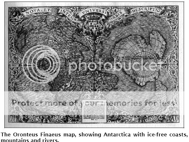
The general shape of the continent was startlingly like the outline of the continent on our modern maps. The position of the South Pole, nearly in the center of the continent, seemed about right. The mountain ranges that skirted the coasts suggested the numerous ranges that have been discovered in Antarctica in recent years. It was obvious, too, that this was no slapdash creation of somebody’s imagination. The mountain ranges were individualized, some definitely coastal and some not. From most of them rivers were shown flowing into the sea, following in every case what looked like very natural and very convincing drainage patterns. This suggested, of course, that the coasts may have been ice-free when the original map was drawn. The deep interior, however, was free entirely of rivers and mountains, suggesting that the ice might have been present there.
Closer investigation of this map confirmed this:
1 It had been copied and compiled from several earlier source maps drawn up according to a number of different projections.2
2 It did indeed show non-glacial conditions in coastal regions of Antarctica, notably Queen Maud Land, Enderby Land, Wilkes Land, Victoria Land (the east coast of the Ross Sea), and Marie Byrd Land.3
3 As in the case of the Piri Reis Map, the general profile of the terrain, and the visible physical features, matched closely seismic survey maps of the subglacial land surfaces of Antarctica.4
Here is something about Ross Sea:
Ross Sea
Further evidence in support of this view arises from the manner in which the Ross Sea was shown by Oronteus Finaeus. Where today great glaciers like the Beardmore and the Scott disgorge themselves into the sea, the
1531 map shows estuaries, broad inlets and indications of rivers. The unmistakable implication of these features is that there was no ice on the Ross Sea or its coasts when the source maps used by Oronteus Finaeus were made: ‘There also had to be a considerable hinterland free of ice to feed the rivers. At the present time all these coasts and their hinterlands are deeply buried in the mile-thick ice-cap, while on the Ross Sea itself there is a floating ice-shelf hundreds of feet thick.
The Ross Sea evidence provides strong corroboration for the notion that Antarctica must have been mapped by some unknown civilization during the extensively ice-free period which ended around 4000 BC. This is emphasized by the coring tubes used, in 1949, by one of the Byrd Antarctic Expeditions to take samples of sediment from the bottom of the Ross Sea. The sediments showed numerous clearly demarcated layers of stratification reflecting different environmental conditions in different epochs: ‘coarse glacial marine’, ‘medium glacial marine’, ‘fine glacial marine’, and so on. The most surprising discovery, however, ‘was that a number of the layers were formed of fine-grained, well-assorted sediments, such as are brought down to the sea by rivers flowing from temperate (that is, ice-free) lands ...’7
Using the ionium-dating method developed by Dr W. D. Urry (which makes use of three different radioactive elements found in sea water8), researchers at the Carnegie Institute in Washington DC were able to establish beyond any reasonable doubt that great rivers carrying fine- grained well-assorted sediments had indeed flowed in Antarctica until about 6000 years ago, as the Oronteus Finaeus Map showed. It was only after that date, around 4000 BC, ‘that the glacial kind of sediment began to be deposited on the Ross Sea bottom ... The cores indicate that warm conditions had prevailed for a long period before that.
Then we have another enigmatik map, Mercator and Buache Map:
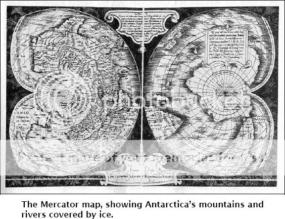
Significantly, Mercator included the Oronteus Finaeus map in his Atlas of 1569 and also depicted the Antarctic on several he himself drew in the same year. Identifiable parts of the then undiscovered southern continent on these maps are Cape Dart and Cape Herlacher in Marie Byrd Land, the Amundsen Sea, Thurston Island in Ellsworth Land, the Fletcher Islands in the Bellinghausen Sea, Alexander I Island, the Antarctic (Palmer) Peninsula, the Weddell Sea, Cape Norvegia, the Regula Range in Queen Maud Land (as islands), the Muhlig-Hoffman Mountains (as islands), the Prince Harald Coast, the Shirase Glacier as estuary on Prince Harald Coast, Padda Island in Lutzow-Holm Bay, and the Prince Olaf Coast in Enderby Land. ‘In some cases these features are more distinctly recognisable than on the Oronteus Finaeus Map,’ observed Hapgood, ‘and it seems clear, in general, that Mercator had at his disposal source maps other than those used by Oronteus Finaeus.
Then we have Buache's Map:
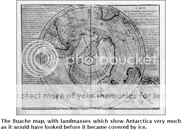
Philippe Buache, the eighteenth-century French geographer, was also able to publish a map of Antarctica long before the southern continent was officially ‘discovered’. And the extraordinary feature of Buache’s map is that it seems to have been based on source maps made earlier, perhaps thousands of years earlier, than those used by Oronteus Finaeus and Mercator. What Buache gives us is an eerily precise representation of Antarctica as it must have looked when there was no ice on it at all.13 His map reveals the subglacial topography of the entire continent, which even we did not have full knowledge of until 1958, International Geophysical Year, when a comprehensive seismic survey was carried out.
That survey only confirmed what Buache had already proclaimed when he published his map of Antarctica in 1737. Basing his cartography on ancient sources now lost, the French academician depicted a clear waterway across the southern continent dividing it into two principal landmasses lying east and west of the line now marked by the Trans- Antarctic Mountains.
Such a waterway, connecting the Ross, Weddell and Bellinghausen Seas, would indeed exist if Antarctica were free of ice. As the 1958 IGY Survey shows, the continent (which appears on modern maps as one continuous landmass) consists of an archipelago of large islands with mile-thick ice packed between them and rising above sea level.
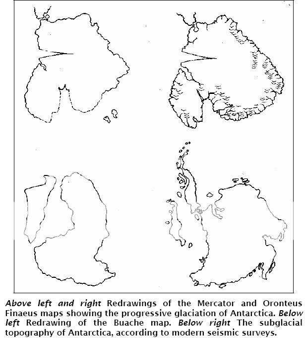
Here is another redrawing of this maps:
Which one is correct?
If we are to go along with orthodox geologists and accept that millions of years have indeed elapsed since Antarctica was last completely free of ice, then all the evidence of human evolution, painstakingly accumulated by distinguished scientists from Darwin on, must be wrong. It seems inconceivable that this could be the case: the fossil record makes it abundantly clear that only the unevolved ancestors of humanity existed millions of years ago—low-browed knuckle-dragging hominids incapable of advanced intellectual tasks like map-making.
Are we therefore to assume the intervention of alien cartographers in orbiting spaceships to explain the existence of sophisticated maps of an ice-free Antarctica? Or shall we think again about the implications of Hapgood’s theory of earth-crust displacement which allows the southern continent to have been in the ice-free condition depicted by Buache as little as 15,000 years ago?
And then we have another map, russian that depicts detailes that were totally unknown in the time the map was made:
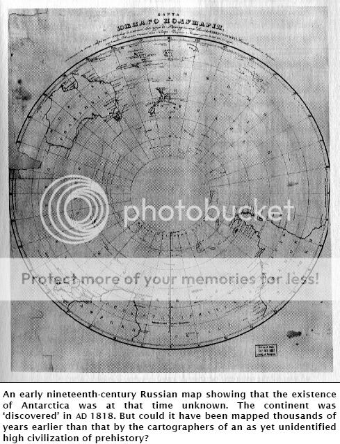
Is it possible that a human civilization, sufficiently advanced to have mapped Antarctica, could have developed by 13,000 BC and later disappeared? And, if so, how much later?
The combined effect of the Piri Reis, Oronteus Finaeus, Mercator and Buache Maps is the strong, though disturbing, impression that Antarctica may have been continuously surveyed over a period of several thousands of years as the ice-cap gradually spread outwards from the interior, increasing its grip with every passing millennium but not engulfing all the coasts of the southern continent until around 4000 BC. The original sources for the Piri Reis and Mercator Maps must therefore have been prepared towards the end of this period, when only the coasts of
Antarctica were free of ice; the source for the Oronteus Finaeus Map, on the other hand, seems to have been considerably earlier, when the ice- cap was present only in the deep interior of the continent; and the source for the Buache Map appears to originate in even earlier period (around
13,000 BC), when there may have been no ice in Antarctica at all.
This is my post. Kind of too long but worth the reading guys.
[edit on 30-11-2006 by Telos]
Interesting thread.
I think, however, the majority of the evidence has repeatedly shown that the further back one goes along the human timeline, the more primitive they are. There are bumps, though, like you said. For instance the Antikythera clock, dating around 65-150BC, was composed of clockwork so intricate and complicated the technology to produce the gears alone was not seen for thousands of years later, much less the science of how they would work together to form a computer. Unless I'm way off base, a computer of that complexity wasn't developed until the 1800's by Charles Babbage.
[edit on 11/30/2006 by thelibra]
Originally posted by golemina
Isn't it customary to include the *cough* crater toy *cough*?
You don't have to be a geology freak (like some people ) to see that the crater toy is missing.
Help me to understand...
Simple. There was no crater left because there was no ground impact. It exploded above the earth's surface. Why is it so hard to accept the idea that the comet came in and exploded over the surface of Tunguska, and felled trees in every direction?
I guess I don't understand why some people are so frightened by the concept that there are BILLIONS of inhabited planets (not to mention other things ) in the Universe...
I'm not, nor have I ever been. If you read my posts around here at all, you'd see that I'm quite the pro-ET member here. I advocate the search for and communication with ETs as a matter of course. Where you got the idea that I wasn't is beyond me.
In case it escaped you... mainstream 'science' STILL views Earth as the center of the universe ( )... STILL view humanity as the only provable 'intelligent' life in the universe ( )... AND wants to somehow pull off an explanation that the explosion of technology that has happened since the 40s/50s is some type of natural evolution due to human creativity...
And you know as well as I do that I don't believe any of that. Just because I believe one thing that scientists have more than adequately explained the cause of doesn't mean that I believe everything they spout. I find it sad that science in general has become so lax on the search for ET and advancing technology towards the stars. There must be a reason why that's the case. Only wish I knew...
TheBorg
These maps purporting to accurately depict Antarctica have one big, big, problem.
Where's the West Antarctic Peninsular?
It's a bit like drawing a map of the British Isle with the coast running straight across from Pembrokeshire in Wales to the Isle of Wight and the whole of Devon, Cornwall and the Severn Sea missing. .
Where's the West Antarctic Peninsular?
It's a bit like drawing a map of the British Isle with the coast running straight across from Pembrokeshire in Wales to the Isle of Wight and the whole of Devon, Cornwall and the Severn Sea missing. .
excellent additions all.....thanks especially to telos for the maps!
essan....why would you expect a map drawn from many older maps to be perfect? if it's real, then it would be a copy of a copy of a copy, etc. as you mentioned, either way it's showing information that according to modern wisdom, they just shouldnt have had at that point. so what is your explanation for the maps?
essan....why would you expect a map drawn from many older maps to be perfect? if it's real, then it would be a copy of a copy of a copy, etc. as you mentioned, either way it's showing information that according to modern wisdom, they just shouldnt have had at that point. so what is your explanation for the maps?
new topics
-
BIDEN Admin Begins Planning For January 2025 Transition to a New President - Today is 4.26.2024.
2024 Elections: 2 hours ago -
Big Storms
Fragile Earth: 3 hours ago -
Where should Trump hold his next rally
2024 Elections: 6 hours ago -
Shocking Number of Voters are Open to Committing Election Fraud
US Political Madness: 7 hours ago -
Gov Kristi Noem Shot and Killed "Less Than Worthless Dog" and a 'Smelly Goat
2024 Elections: 7 hours ago -
Falkville Robot-Man
Aliens and UFOs: 8 hours ago -
James O’Keefe: I have evidence that exposes the CIA, and it’s on camera.
Whistle Blowers and Leaked Documents: 8 hours ago -
Australian PM says the quiet part out loud - "free speech is a threat to democratic dicourse"...?!
New World Order: 9 hours ago -
Ireland VS Globalists
Social Issues and Civil Unrest: 10 hours ago -
Biden "Happy To Debate Trump"
2024 Elections: 10 hours ago
top topics
-
James O’Keefe: I have evidence that exposes the CIA, and it’s on camera.
Whistle Blowers and Leaked Documents: 8 hours ago, 17 flags -
Australian PM says the quiet part out loud - "free speech is a threat to democratic dicourse"...?!
New World Order: 9 hours ago, 15 flags -
Blast from the past: ATS Review Podcast, 2006: With All Three Amigos
Member PODcasts: 12 hours ago, 13 flags -
Biden "Happy To Debate Trump"
2024 Elections: 10 hours ago, 12 flags -
Ireland VS Globalists
Social Issues and Civil Unrest: 10 hours ago, 9 flags -
Mike Pinder The Moody Blues R.I.P.
Music: 13 hours ago, 8 flags -
What is the white pill?
Philosophy and Metaphysics: 12 hours ago, 6 flags -
Shocking Number of Voters are Open to Committing Election Fraud
US Political Madness: 7 hours ago, 6 flags -
Where should Trump hold his next rally
2024 Elections: 6 hours ago, 5 flags -
Gov Kristi Noem Shot and Killed "Less Than Worthless Dog" and a 'Smelly Goat
2024 Elections: 7 hours ago, 5 flags
active topics
-
BIDEN Admin Begins Planning For January 2025 Transition to a New President - Today is 4.26.2024.
2024 Elections • 11 • : Euronymous2625 -
RAAF airbase in Roswell, New Mexico is on fire
Aliens and UFOs • 11 • : Ophiuchus1 -
SETI chief says US has no evidence for alien technology. 'And we never have'
Aliens and UFOs • 79 • : SchrodingersRat -
Gold and silver prices....woo hoo
History • 88 • : SchrodingersRat -
University of Texas Instantly Shuts Down Anti Israel Protests
Education and Media • 314 • : Schmoe3755 -
President BIDEN's FBI Raided Donald Trump's Florida Home for OBAMA-NORTH KOREA Documents.
Political Conspiracies • 39 • : AwakeNotWoke -
Gov Kristi Noem Shot and Killed "Less Than Worthless Dog" and a 'Smelly Goat
2024 Elections • 55 • : AwakeNotWoke -
Big Storms
Fragile Earth • 13 • : AwakeNotWoke -
SHORT STORY WRITERS CONTEST -- April 2024 -- TIME -- TIME2024
Short Stories • 26 • : Encia22 -
Biden "Happy To Debate Trump"
2024 Elections • 50 • : Lumenari