It looks like you're using an Ad Blocker.
Please white-list or disable AboveTopSecret.com in your ad-blocking tool.
Thank you.
Some features of ATS will be disabled while you continue to use an ad-blocker.

Looking for a better map of the Atlantic ocean
page: 4share:
originally posted by: All Seeing Eye
The Earth crust displacement theory by Charles H. Hapgood
Very quickly going over his theory, which is a bit difficult to comprehend,
I read "Maps of the Ancient Sea Kings" about a million years ago. I can pretty much guarantee that if you read it you will like it.
www.amazon.com...=sr_1_1?keywords=In+Maps+of+the+Ancient+Sea+Kings&qid=1559250288&s=books&s r=1-1-catcorr
originally posted by: All Seeing Eye
For one of them, they built on the site of a pre flood community. And there is circumstantial evidence, to prove it.
Anyone interested in "Seeing" it?
What's this heresy you speak of?
originally posted by: spiritualarchitect
originally posted by: All Seeing Eye
There are marks in the ocean beds that go against the natural spreading of the planet. They appear to have been created by a rather large sphere being dragged over the beds of the ocean.
And yes, the diameters of those smudge marks on the beds of our oceans coincide with the diameters of those Lunar Dark Circles.
Our OP may disagree, since we are off topic, but you guys have really hit it out of the park with some of these post.
A decade ago I heard the idea of the moon being dragged out of orbit to purposely cause the great flood. But Are you saying the Moon may have been physically dragged across the planet itself?
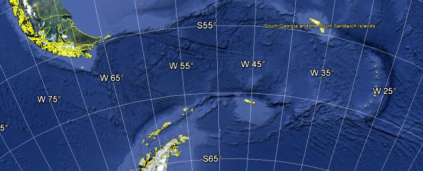
And in that lies the great unbelievably. Now, I cant say whether the moon possess its own propulsion system, or rely on a separate Tow unit. What the evidence points to is a rather large sphere coming into contact with the earth. The point where it contacted was approx 300 miles in diameter. In this case, the great flood, it appears to have happened right where South America and Antarctica were connected by a Isthmus. This can be seen on Google Earth.
The swath follows the radius of the earth and runs for about 1600 miles, give or take. It ends in the South Sandwich Ridge, witch is also radiused at 300 miles, give or take.
The Sandwich Islands are a result of the debris collected when it stopped. Take a basket ball and skid it though mud, you will get the same result. All I can say is it, was not spinning or rolling, if it were, there would be no pile at the end of travel.
It might sound unbelievable, but the sphere was used in essence, like a break. The Sandwich Islands are evidence that the planet stopped rotating. But the greater observation is, Planet Earth, before this event, was rotating in the opposite direction. The Sun, came up in the West. There are legends about this.
Now, when I look up at night, and see that big, dry, dusty, sphere, I wonder what it would look like. Of course water would transfer to that sphere in the contact area, leaving a dark circular area. Lets see, where have I seen that before?
Moon being drug, our Moon? No way to really prove that, unless someone would be interested in studying the Sandwich islands, looking for, lets say, Titanium ore. You would only need to search the westward areas, on the islands, and below. If it were our moon, I'm certain some may be found. Not in abundance, and only in trace amounts.
I have already shared what effects stopping the earths rotation would look like. It fits the Great Flood to a tee.
There are other marks in the ocean that appear to have adjusted the planets angle to the Sun. It did not stop the rotation.
a reply to: All Seeing Eye
I can kind of see what you are talking about.
images.app.goo.gl...
images.app.goo.gl...
Talk about small world, I just noticed that if you click on that first link and click on the third top photo from left, you link to my old ATS Atlantis thread!
I can kind of see what you are talking about.
images.app.goo.gl...
images.app.goo.gl...
Talk about small world, I just noticed that if you click on that first link and click on the third top photo from left, you link to my old ATS Atlantis thread!
edit on 30-5-2019 by spiritualarchitect because: Atlantis!
That will take some time to put together something that is understandable. As I said it will require its own post. Sorry. Too much involved to just put it here. You know someone who is knowledgeable and willing to co post? Work together?
originally posted by: spiritualarchitect
originally posted by: All Seeing Eye
For one of them, they built on the site of a pre flood community. And there is circumstantial evidence, to prove it.
Anyone interested in "Seeing" it?
What's this heresy you speak of?
originally posted by: spiritualarchitect
a reply to: All Seeing Eye
I can kind of see what you are talking about.
images.app.goo.gl...
images.app.goo.gl...
Talk about small world, I just noticed that if you click on that first link and click on the third top photo from left, you link to my old ATS Atlantis thread!
Those are but a small part of the bigger picture
This, is the whole event.
Ill see if I can find the book you mentioned, sounds interesting.
Your saying no one would find this interesting?
originally posted by: spiritualarchitect
a reply to: All Seeing Eye
No one, so do not go through a lot of work over it.
originally posted by: spiritualarchitect
a reply to: All Seeing Eye
No one, so do not go through a lot of work over it.
This isnt interesting?
Or, this?
And, maybe more interesting for us all, can we reduce the sea to the ice age level and see something. I am especially interested in this big red triangle in the middle of the ocean.
First question, yes. We actually can reduce the sea levels. It would require tilting the Earth back to its original inclination which was approximately 10 - 15 degrees to the Sun. This would put the North Pole back to the Magnetic North Pole, in the Laptev Sea. It would also shift the South Pole accordingly. This would expose more land mass to Ice buildup, far more. The Sea levels would slowly return to "Normal". The resulting climate change would mean shorter Fall and Spring seasons. The mechanics of the "Shift" are highly debatable.
That Triangle is where Continental Plates merge. It is a 3 way split which produces a "Triangle" area. The Mid Atlantic Rift is also joined by another rift that runs to basically the Straights Of Gibraltar. The Triangle is a resulting pressure ridge and formed from volcanic action. Dropping the Sea Level 400 ft would expose much more surface area in that zone. But not a great amount.
Evidence is mounting that the City Island of Atlantis (Center of Operations) is actually located in Eastern Africa as annotated by the The Piri Re'is Map. As Atlantis was a Kingdom it would of had stations or post or conquered lands elsewhere in its dominion. Your red triangle most assuredly, is part of its domain.
Hope that helps.
a reply to: All Seeing Eye
I was saying "No one" I knew of who could co-post.
That big underwater picture does more justice to the bowling ball mud sludge look.
Where are those ruins located in the other picture?
I was saying "No one" I knew of who could co-post.
That big underwater picture does more justice to the bowling ball mud sludge look.
Where are those ruins located in the other picture?
Going to have to start with the logic first, setting up the big picture.
originally posted by: spiritualarchitect
a reply to: All Seeing Eye
I was saying "No one" I knew of who could co-post.
That big underwater picture does more justice to the bowling ball mud sludge look.
Where are those ruins located in the other picture?
If the "Eye" of the Sahara is actually the Island City of Atlantis, then, there isn't enough real estate to support its operations within the island itself. You would need Fields upon fields to produce the Grains. Atlantis is known for many mining operations, gold, silver, and especially a "Blue" gem. Debatable which one it was. You would need many sheep/ goat herders, etc. The lands around the eye, must support the King and his subjects/ armies, etc.
Logic would dictate that much transportation from one area to another would have been required, much by land roads, and much by river. The area has a vast network of rivers that used to go to the sea, and to the island itself. Many of those channels are under sand and not observable. But if the rivers were used, then there would be communities along those rivers to support shipping and transportation. So logically you would start the search there. Rivers.
There are many that no longer produce running river water, but occasionally you will find spots in those rivers that underground water will give a small amount, and probably seasonally.
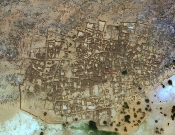
Starting the search close to the Island, and working out. The first discovered is only 14 miles away at Ouadane. It is presently occupied but to the east, at the ancient riverbed there appears to be a dock. The ruins are, given the amount of time that has passed, very well preserved. This community, I suspect, is post flood. Built after the flood by people returning expecting to pick up where they left off, except the weather changed. Water no longer flowed through the rivers, and eventually people abandon the sight. It wasn't until late that modern man returned. The buildings follow the same building technique as described in the stories of Atlantis, small building blocks. The surrounding area seems to be devoid of any stones laying around. There are signs northwest of that area that indicate, pre flood settlements. Actually, the whole area seems to have been built on a large pre flood city. But all the pre flood building stones were used to build the post flood community, so no large piles of stone. The purpose of this community is not apparent.
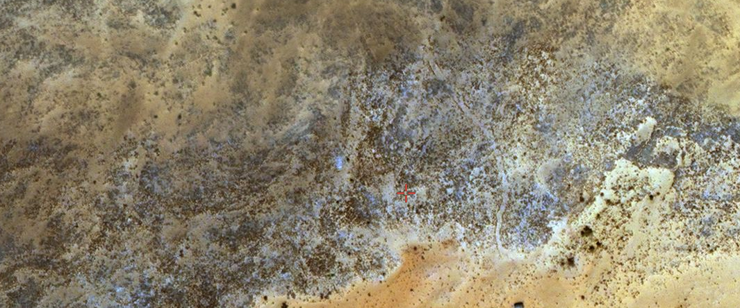
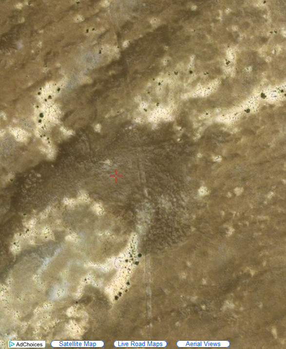
The next has no map name. It is situated at the point where two rivers merged and from there ran south. This site, like the first, has evidence the post flood abandonment's were built on top of the pre flood ruins. This one, like the first, was built with the stones of the first community. But, unlike the first, used the stones to the east, as this area is also devoid of rocks and stone laying about. For some unknown reason they left the ruins in tact, to the east. The post flood abandonment's appears to be aprox 1/20 the size of the pre flood community. The reason for this settlement may have been "Mining".
Before one could comprehend this being a mining town, one must jump back in time. There was no EPA, there was no FDA etc. The worker himself was a subject to the King, or slave, if you will. There was no recourse for grievances. You did what you were told. Period. Complaining about all the dust would only get you flogged. And in that, is the clue.
I followed a road north that went north on the west side of the ruin. It was old and didn't appear to have been used recently. It only ran for 6 miles or so, lost it a few times but picked it up later. It lead to a area that seemed to be open pit mines. Piles and piles of "Blue" material about the general area. It appeared to be very dusty, blue dust. But this dust seemed to only be collected in certain areas. Was this the where the "Blue Gems" of Atlantis were mined from? At any rate, these areas seem to be collection points where this blue material was gathered awaiting its wagon trip back down to that community on the river, for processing, cutting, polishing, sorting, or what ever they were doing.
Jumping back to the community, there it was. All the original community could now be seen, by seeing the "Blue" dust, everywhere. Except, in the post flood abandonment's. Only two rooms had the blue dust in them. The dust of thousands of years, piling up on work floors, buildings, roadways, ally's, etc. The dust was so thick and deep, the flood itself couldn't wash it all away. It sits approx 40 miles, down river of the eye.
Obviously, I could be wrong about everything. It would require "boots on the ground" in order to confirm any of it. But if true, I may have made someone a millionaire. Then again, it might be copper, except copper ore, is green.
If I were a wealthy individual, I would be on the next boat!
One other thing, that Swath mark. In the Oronteus Finaeus map, it shows the Isthmus between South America and Antarctica, intact. Now shake your head for a moment and think about that.
edit on PMFridayFriday stAmerica/ChicagoAmerica/Chicago5158 by All Seeing Eye because: (no reason
given)
originally posted by: spiritualarchitect
a reply to: All Seeing Eye
Where are those ruins located in the other picture?
As I said, its quite involved attempting to present 12,000 years in one little post. I have already discovered almost 2 dozen locations that support the idea of a large settlement in this area. I'm going to have to post a new thread to try and share it. My information is about Atlantis, but not exactly about Ocean Maps, and is unfair to the op.
The entire Planet is covered in these types of ruins...all caused by a VGCDW.....a child can find them if someone simply tells them the TRUTH and what
to look for….you friend have truth on your side......follow it up....you have Atlantis now move on....we have New York to but finding New York 3655
years after its demise does not give us a fair statement globally.....Atlantis is only the beginning.
originally posted by: All Seeing Eye
That will take some time to put together something that is understandable. As I said it will require its own post. Sorry. Too much involved to just put it here. You know someone who is knowledgeable and willing to co post? Work together?
originally posted by: spiritualarchitect
originally posted by: All Seeing Eye
For one of them, they built on the site of a pre flood community. And there is circumstantial evidence, to prove it.
Anyone interested in "Seeing" it?
What's this heresy you speak of?
The Vlar Global Continental Displacement Wave Model already includes this data generically......it might help you out...you have the truth by the tail....lol.
originally posted by: All Seeing Eye
originally posted by: Hanslune
originally posted by: All Seeing Eye
Its not all of the scientific community that fight the idea, only a small portion, at the top.
At the top? What top?
You almost made me laugh at that question. Research the history of science.
You avoided the question who is the top scientist in say UK or USA and how does this person control every other scientist?
originally posted by: Hanslune
originally posted by: All Seeing Eye
Its not all of the scientific community that fight the idea, only a small portion, at the top.
At the top? What top?
Top... Men.
Harte
originally posted by: schuyler
But there was a Flood. And the sea level rose 400 feet at the Younger Dryas.
SNIP
Oddly, the scientific community will never admit to "The Flood," but they will readily admit to the fact that the sea level rose 400 feet.
Sea level has risen about 120 meters since the peak of the last ice age. That's only 393 feet since the maximum amount of water was locked into ice.
Of that rise, by FAR the biggest pulse was only 30 meters (Meltwater Pulse 1A - which began around 15k years ago,) and that occurred over a period of approximately 1000 years.
You think that's a flood?
Only in geological time.
Nobody needs to be rescued from a "flood" where waters are rising at 3 centimeters a year.
Harte
originally posted by: schuyler
9,000 years ago in Plato's time would make it about 11,000 years ago our time, which is right in the ballpark of the comet impact hypothesis. I quite realize Atlantis has been placed nearly everywhere on Earth, including Antarctica. But there's one place "beyond the pillars of Hercules" that is often overlooked. If you are in North America, look down at your feet. Kind of meets the requirements, doesn't it?
No, because my feet are still dry.
Harte
originally posted by: All Seeing Eye
Which by the way, is very convenient that the Oceans name co insides with Atlas, Atlantis.
It's not convenience.
The name of the ocean comes from the Greeks, through the Romans.
We're still calling it the Ocean of Atlas today. We just use a hard "c" at the end of the word, rather than a soft one as it's pronounced in ancient Greek.
Harte
new topics
-
Shocking Number of Voters are Open to Committing Election Fraud
US Political Madness: 43 minutes ago -
Gov Kristi Noem Shot and Killed "Less Than Worthless Dog" and a 'Smelly Goat
2024 Elections: 1 hours ago -
Falkville Robot-Man
Aliens and UFOs: 1 hours ago -
James O’Keefe: I have evidence that exposes the CIA, and it’s on camera.
Whistle Blowers and Leaked Documents: 2 hours ago -
Australian PM says the quiet part out loud - "free speech is a threat to democratic dicourse"...?!
New World Order: 3 hours ago -
Ireland VS Globalists
Social Issues and Civil Unrest: 3 hours ago -
Biden "Happy To Debate Trump"
Mainstream News: 4 hours ago -
RAAF airbase in Roswell, New Mexico is on fire
Aliens and UFOs: 4 hours ago -
What is the white pill?
Philosophy and Metaphysics: 5 hours ago -
Blast from the past: ATS Review Podcast, 2006: With All Three Amigos
Member PODcasts: 6 hours ago
top topics
-
A Warning to America: 25 Ways the US is Being Destroyed
New World Order: 14 hours ago, 21 flags -
Blast from the past: ATS Review Podcast, 2006: With All Three Amigos
Member PODcasts: 6 hours ago, 11 flags -
Biden "Happy To Debate Trump"
Mainstream News: 4 hours ago, 8 flags -
Mike Pinder The Moody Blues R.I.P.
Music: 6 hours ago, 7 flags -
James O’Keefe: I have evidence that exposes the CIA, and it’s on camera.
Whistle Blowers and Leaked Documents: 2 hours ago, 5 flags -
Australian PM says the quiet part out loud - "free speech is a threat to democratic dicourse"...?!
New World Order: 3 hours ago, 5 flags -
What is the white pill?
Philosophy and Metaphysics: 5 hours ago, 5 flags -
Ireland VS Globalists
Social Issues and Civil Unrest: 3 hours ago, 4 flags -
RAAF airbase in Roswell, New Mexico is on fire
Aliens and UFOs: 4 hours ago, 4 flags -
Putin, Russia and the Great Architects of the Universe
ATS Skunk Works: 9 hours ago, 3 flags
active topics
-
Candidate TRUMP Now Has Crazy Judge JUAN MERCHAN After Him - The Stormy Daniels Hush-Money Case.
Political Conspiracies • 806 • : Annee -
The functionality of boldening and italics is clunky and no post char limit warning?
ATS Freshman's Forum • 14 • : Encia22 -
MULTIPLE SKYMASTER MESSAGES GOING OUT
World War Three • 99 • : cherokeetroy -
University of Texas Instantly Shuts Down Anti Israel Protests
Education and Media • 298 • : CriticalStinker -
Gov Kristi Noem Shot and Killed "Less Than Worthless Dog" and a 'Smelly Goat
2024 Elections • 25 • : FlyersFan -
Falkville Robot-Man
Aliens and UFOs • 4 • : Kurokage -
Shocking Number of Voters are Open to Committing Election Fraud
US Political Madness • 1 • : YourFaceAgain -
-@TH3WH17ERABB17- -Q- ---TIME TO SHOW THE WORLD--- -Part- --44--
Dissecting Disinformation • 700 • : Thoughtful3 -
Putin, Russia and the Great Architects of the Universe
ATS Skunk Works • 26 • : RussianTroll -
Re-election Tactic - JOE BIDEN Hints He May Put Books in the Homes of Black People.
2024 Elections • 30 • : WeMustCare