It looks like you're using an Ad Blocker.
Please white-list or disable AboveTopSecret.com in your ad-blocking tool.
Thank you.
Some features of ATS will be disabled while you continue to use an ad-blocker.

pre pyramid plateau
page: 7share:
a reply to: Byrd
"Those are the tombs of the nobles and elites. "
hmmmm. i kinda had the impression these guys liked to have tombs in cliffs, are they in the escarpment or on the plateau?
just as a bit of chat as it were, an old arab guy many years ago told me that there were tombs shaped as step pyramids, but different and smaller and the reasoning was thus-
in some areas, you cannot effectively bury your beloveds so you put them in a box, and you have a place and put rocks on it (we make a cairn in n w europe) to stop the jackals getting in. when you have enough dead, all neatly boxed up you have a square then the next most expedient thing is to make a smaller layer on top, and so forth.
just throw in that, it may be a rationalisation, or a small town tradition or practice but ive never seen it in academia.
an old story from a hot place
originally posted by: username74
a reply to: Byrd
well ok, if you must, but it should be noted that those passages are not for people, so can we make the massive leap that they may be for liquid?
No. We should ask "how big are those?" (because the site is not to be trusted) and "what did they find there" and "what is it associated with (what's at the bottom)?" and "what age is it?"
The whole area has been active for over 5,000 years, with modifications and activity going on throughout that time. Digs and exploration and mapping has been done at the site for about 200 years.
Someone at another forum had made a big deal about a "large hole" with what appeared to be salt crystals in the enclosure of the Sphinx. When I went to Egypt last year, I walked around the enclosure and looked for the hole. Finally found it... and it was smaller than the palm of my hand.
as for the picture, i would say it is looking due west from the most northerly pyramid, whatever that implies?
thanks for the links tho
Yep. That's what I told Harte. That's the Western Cemetery, the place where the nobles are buried. You can see photos of the tombs at some of the links I left.
originally posted by: username74
a reply to: Byrd
"Those are the tombs of the nobles and elites. "
hmmmm. i kinda had the impression these guys liked to have tombs in cliffs, are they in the escarpment or on the plateau?
You're probably thinking of the Valley of the Kings and the New Kingdom burial practices for pharaohs. This is almost 1200 years before the cliffside tombs. Some of the high officials have tombs at Giza that are partly carved out of the flanks of the hillside, but they wanted them to be visible so people would leave offerings.
just as a bit of chat as it were, an old arab guy many years ago told me that there were tombs shaped as step pyramids, but different and smaller and the reasoning was thus-
in some areas, you cannot effectively bury your beloveds so you put them in a box, and you have a place and put rocks on it (we make a cairn in n w europe) to stop the jackals getting in. when you have enough dead, all neatly boxed up you have a square then the next most expedient thing is to make a smaller layer on top, and so forth.
just throw in that, it may be a rationalisation, or a small town tradition or practice but ive never seen it in academia.
an old story from a hot place
The evolution of grave types is pretty easy to see. Predynastic practices were pit burials where people were put in a large hole in the ground with pottery and blankets and so forth and stones put over it. This evolved to a kind of underground room and then in the early dynastic period (3,000 BC to about 2200 BC) the rulers and nobles had big tombs that looked a bit like palaces and had interior rooms and statues and offerings and things they used and loved during their lifetimes. They're called mastaba tombs.
Kings always had to have something better, so they had big courtyards and other buildings and a wall around their tomb... and a series of "benches." It was Djosers architect, Imhotep, who designed the first huge step pyramid that was made entirely out of stone. They are still trying to restore it, so we couldn't go down in it and see its nearly 2 kilometers of tunnels (a tunnel maze) and store rooms.
But it's pretty darn big.
After Djoser, other pharaohs continued the stepped pyramids until Sneferu (Khufu's father) - who loved pyramids and built three or four of them, including the first smooth sided ones.
a reply to: Byrd
No. We should ask "how big are those?" (because the site is not to be trusted) and "what did they find there" and "what is it associated with (what's at the bottom)?" and "what age is it?"
clearly not for people!.
they are not that big. and if they are that in no way precludes a fluvial function. have you noticed they are square ish, preccision does not seem to be an issue but four corners do.
do you think this may be a feature of note, like in the pit in the subterranean chamber of the great pyramid.
it would perhaps lead to some speculation as to why your sink at home does not have a square plughole
in relation to what did they find there, i dont know, maybe something left by water, recent or otherwise, is it relevant to their hypothetical function, on initial assesment. not to say your critisms are not valid but can we start with a hypothesis and find some evidence to perhaps construct a theory as to their function?
a reply to: Byrd
"The evolution of grave types is pretty easy to see. Predynastic practices were pit burials where people were put in a large hole in the ground with pottery and blankets and so forth and stones put over it. This evolved to a kind of underground room and then in the early dynastic period (3,000 BC to about 2200 BC) the rulers and nobles had big tombs that looked a bit like palaces and had interior rooms and statues and offerings and things they used and loved during their lifetimes. They're called mastaba tombs. "
well, burial types and progression of such is illuminating and as ever when we see parallels between geographically isolated populations its easier to to draw a parallel evolution theory than a linked civilisation. so here i would point to s. america and early dynastic egypt, not trying to link the civilisations, aware of different timelines etc, but when we look at the 'style' of the very early dynastic egyptian constructions, and so more specifically, the osireion, where we see the megalithic 'beamwork' like the stereotypical henge with the proturberances or lumps on the curved facade of the interlocking blocks, stylistically identical to sacsayhuaman. now i have read that wood was apparently the first medium and the techniques were adapted to stone and i can go with this a way.
oh and the poured metal staples seemingly to bind the rock in abscence of more hetrogeneous rock jointing which we see in both continents,and which must have endured a philosophical evolution under massive and prolonged seismic activity to make this protection neccesary and so ingrained to the design,due to the prolonged labour and planning involved, although various in precise morphology and composition it is another stiking similarity between the two locations. should we not look, in view of these indicators, (and not linking these population centres across space and time) for a more central aggregation points, no longer existant, through prehistory.
something like easter island.
by the by, on the more mundane side of burial, and i hope its the right one (and i know you dont generally have the time to follow links) its interesting to see the development of the long barrows from hearths to small stone circles to mounds forts and diverse others, on an island group that really got to run, with influences, on its own path for a long while. its a bbc doc' probably 30 years old by now but quite charming
www.youtube.com...
or maybe not so old, but hes been around a while
the relevant parts 12 mins in or so, the orkney isles
"The evolution of grave types is pretty easy to see. Predynastic practices were pit burials where people were put in a large hole in the ground with pottery and blankets and so forth and stones put over it. This evolved to a kind of underground room and then in the early dynastic period (3,000 BC to about 2200 BC) the rulers and nobles had big tombs that looked a bit like palaces and had interior rooms and statues and offerings and things they used and loved during their lifetimes. They're called mastaba tombs. "
well, burial types and progression of such is illuminating and as ever when we see parallels between geographically isolated populations its easier to to draw a parallel evolution theory than a linked civilisation. so here i would point to s. america and early dynastic egypt, not trying to link the civilisations, aware of different timelines etc, but when we look at the 'style' of the very early dynastic egyptian constructions, and so more specifically, the osireion, where we see the megalithic 'beamwork' like the stereotypical henge with the proturberances or lumps on the curved facade of the interlocking blocks, stylistically identical to sacsayhuaman. now i have read that wood was apparently the first medium and the techniques were adapted to stone and i can go with this a way.
oh and the poured metal staples seemingly to bind the rock in abscence of more hetrogeneous rock jointing which we see in both continents,and which must have endured a philosophical evolution under massive and prolonged seismic activity to make this protection neccesary and so ingrained to the design,due to the prolonged labour and planning involved, although various in precise morphology and composition it is another stiking similarity between the two locations. should we not look, in view of these indicators, (and not linking these population centres across space and time) for a more central aggregation points, no longer existant, through prehistory.
something like easter island.
by the by, on the more mundane side of burial, and i hope its the right one (and i know you dont generally have the time to follow links) its interesting to see the development of the long barrows from hearths to small stone circles to mounds forts and diverse others, on an island group that really got to run, with influences, on its own path for a long while. its a bbc doc' probably 30 years old by now but quite charming
www.youtube.com...
or maybe not so old, but hes been around a while
edit on 9-8-2016 by username74 because: (no reason given)
the relevant parts 12 mins in or so, the orkney isles
edit on 9-8-2016 by username74 because: (no reason given)
originally posted by: username74
a reply to: username74
oooh,look what i've found!
i have no idea about this website, so earthmilk, yeah , i know, sounds nasty, but a photo is a photo, enjoy
earthmilkancientenergy.com...
oh my..I think I have never ever seen a more idiotic site like this...
even dumber than the water pump theory..
a reply to: anti72
"oh my..I think I have never ever seen a more idiotic site like this...
even dumber than the water pump theory.. "
are you sure?
"yeah , i know, sounds nasty, but a photo is a photo, enjoy"
did you read that bit?
looking for a little bit of trolling are we?
"oh my..I think I have never ever seen a more idiotic site like this...
even dumber than the water pump theory.. "
are you sure?
"yeah , i know, sounds nasty, but a photo is a photo, enjoy"
did you read that bit?
looking for a little bit of trolling are we?
I would like to know more about that earthmilk sites pictures.
earthmilkancientenergy.com...
Does anyone know more about the pics?
I know that there will be a lot of missing bits to these wells and shafts. But...
Do some horizontal shafts fall towards the Nile?
Do some of the horizontal shafts show backfall? (Not angled towards the Nile).
Is there a kind of dividing line through the site where backfall stars to be seen?
How many horizontal shafts in each well?
a reply to: blackcrowe
well then you would have to have accurate positions and bearings and scale and plot them on mapping software, which could probably take the rest of your life and a hundred others
or we would all have done it, but if you do photo searches and catalogue them then that might be interesting, if you have the tme, i dont
good luck
a reply to: username74
It looks elaborate.
I think it's a complete circulatory system. Feeding fresh water to where it's needed. And returning sewer/wastewater back to the Nile. Any evidence for surface water drainage is probably long gone now.
A spade in the desert.
I think they were a bit more civilized than that. Although. I might be wrong.
It wasn't really made for no reason. They probably didn't realize that the Nile would change course.
But. i'm sure that plenty of generations enjoyed the benefits of their efforts.
But. I'm only going off a few pics and a bit of comment.
Would be good to see it all though.
a reply to: blackcrowe
I have searched the internet trying to find anything more about these wells and shafts that seem to scatter the site.
I can't find anything.
When i first saw the photo's. I instantly thought of water and sewer as the reasons.
I am hoping that similar, more intact examples will be found in the future on new find excavations.
As i could not find anything else about them. Just going off the photo's in the article. Ignoring the comments in the article. I have an idea for these.
The Giza site was going to be flooded with gangs of workers. As well as all the rest of the workforce needed to supply the gangs.
These workers were skilled and worth looking after.
Before work could start on the pyramids. The site would have been prepared.
Fresh water was needed at various places throughout the site.
Washing/bathing/laundry services would be needed.
A sanitary system would be needed.
I was searching for confirmation of 2 or more horizontal shafts oddly showing backfall from one well shaft to the other.
No information seems to exist.
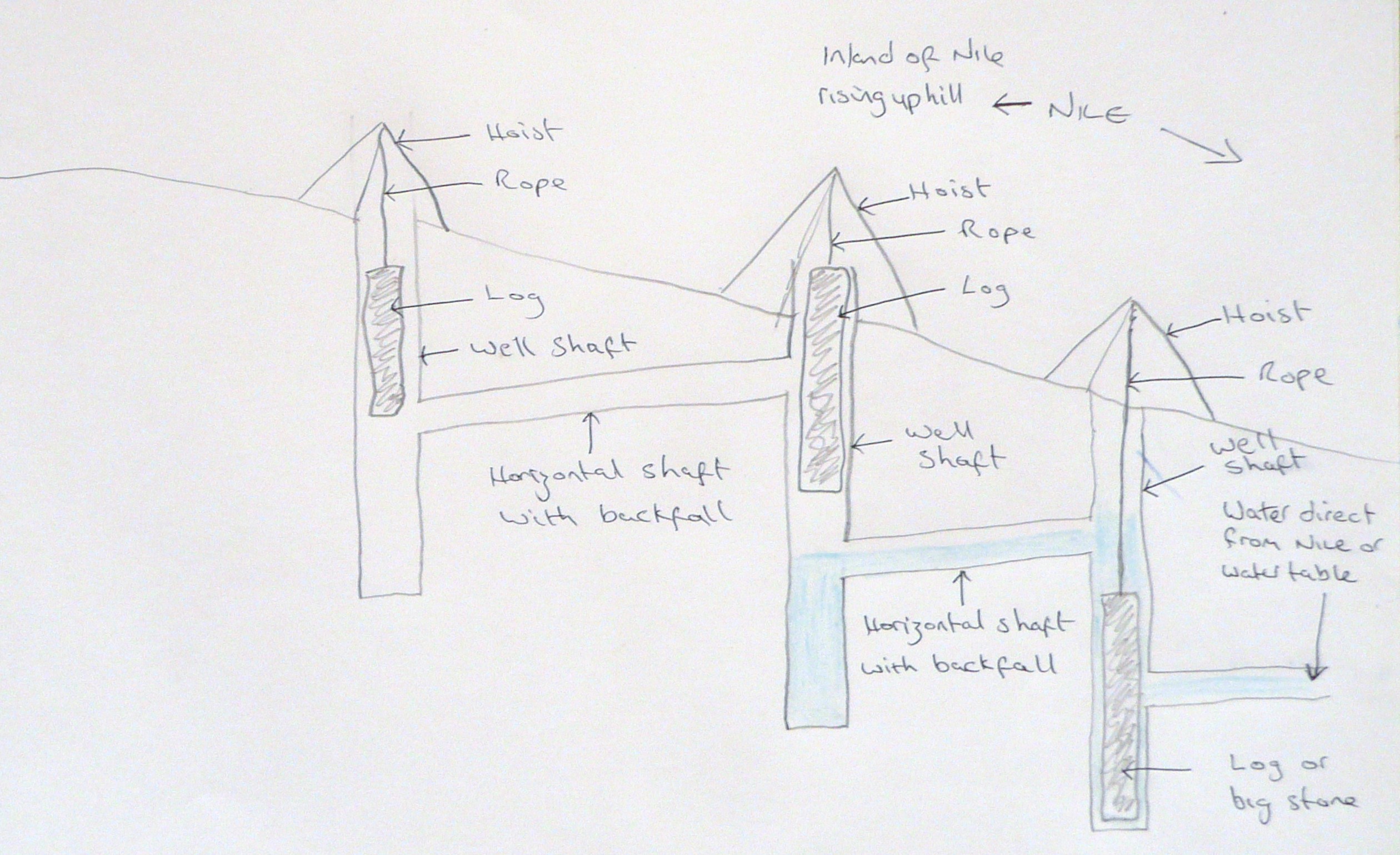
I think that water either direct from the Nile. Or diverted from it to a series of wells and shafts that carried clean water around the site.
A big problem would be how to get water to points above the Nile or water table.
Water would enter a well through a horizontal shaft. Another horizontal shaft would connect that well to another well higher up the site, using backfall. The second/outlet shaft would be much higher than the first/inlet shaft. It would work by a log/tree trunk or big rock being lowered into the well from a hoist above the well opening. As the log drops down the well. The water is pushed up the well shaft and down the outlet shaft which will become the inlet shaft in the connecting well. And so on.
I have drawn the design. Simple and easy to see how this system worked.
I have uploaded it and it's apparently in my gallery. But i can't seem to put it in this post.
If anyone can help. I would appreciate it.
edit on 14-8-2016 by blackcrowe because: (no reason given)
I have searched the internet trying to find anything more about these wells and shafts that seem to scatter the site.
I can't find anything.
When i first saw the photo's. I instantly thought of water and sewer as the reasons.
I am hoping that similar, more intact examples will be found in the future on new find excavations.
As i could not find anything else about them. Just going off the photo's in the article. Ignoring the comments in the article. I have an idea for these.
The Giza site was going to be flooded with gangs of workers. As well as all the rest of the workforce needed to supply the gangs.
These workers were skilled and worth looking after.
Before work could start on the pyramids. The site would have been prepared.
Fresh water was needed at various places throughout the site.
Washing/bathing/laundry services would be needed.
A sanitary system would be needed.
I was searching for confirmation of 2 or more horizontal shafts oddly showing backfall from one well shaft to the other.
No information seems to exist.
I think that water either direct from the Nile. Or diverted from it to a series of wells and shafts that carried clean water around the site.
A big problem would be how to get water to points above the Nile or water table.
Water would enter a well through a horizontal shaft. Another horizontal shaft would connect that well to another well higher up the site, using backfall. The second/outlet shaft would be much higher than the first/inlet shaft. It would work by a log/tree trunk or big rock being lowered into the well from a hoist above the well opening. As the log drops down the well. The water is pushed up the well shaft and down the outlet shaft which will become the inlet shaft in the connecting well. And so on.
I have drawn the design. Simple and easy to see how this system worked.
I have uploaded it and it's apparently in my gallery. But i can't seem to put it in this post.
If anyone can help. I would appreciate it.
edit on 14-8-2016 by blackcrowe because: (no reason given)
edit on 15-8-2016 by blackcrowe because: (no reason given)
a reply to: blackcrowe
Or they used the canal specifically designed to bring water to the construction site, which IIRC was excavated in 1995
Or they used the canal specifically designed to bring water to the construction site, which IIRC was excavated in 1995
a reply to: blackcrowe
hmm, you could try this www.ancient-wisdom.com...
i wont vouch for it but its a start
by the way youve nearly drawn the basic constituents of a ram pump by accident, except three of them, sideways as it were...lol
hmm, you could try this www.ancient-wisdom.com...
i wont vouch for it but its a start
by the way youve nearly drawn the basic constituents of a ram pump by accident, except three of them, sideways as it were...lol
originally posted by: blackcrowe
a reply to: blackcrowe
Washing/bathing/laundry services would be needed.
A sanitary system would be needed.
A couple of bits of information that you might not have but archaeologists are well aware of:
* many workmen worked in the nude. There's lots of tomb paintings and other material showing nude workmen.
* they used a sort of "sandbox" as their toilets. No water needed.
Also, the Nile wasn't in the same channel where it's found today, and the main workforce was there only during the flood when the water was close to the pyramid site.
And they use shadoufs to put water into canals. There were no big trees in Egypt - palm logs are far too soft for much of anything. That's why wood was so expensive and why they sent to Lebanon for hardwoods for furniture and coffins.
The culture's fascinating... if you're interested, I can dig up some of the material on their engineering methods.
originally posted by: Byrd
Also, the Nile wasn't in the same channel where it's found today, and the main workforce was there only during the flood when the water was close to the pyramid site.
And they use shadoufs to put water into canals.
Are you sure? I think the shaduf post dates the O.K. in Egypt, though I don't know how they would have raised water without it.
Harte
originally posted by: Harte
originally posted by: Byrd
Also, the Nile wasn't in the same channel where it's found today, and the main workforce was there only during the flood when the water was close to the pyramid site.
And they use shadoufs to put water into canals.
Are you sure? I think the shaduf post dates the O.K. in Egypt, though I don't know how they would have raised water without it.
Harte
originally posted by: Marduk
a reply to: blackcrowe
Or they used the canal specifically designed to bring water to the construction site, which IIRC was excavated in 1995
a reply to: Harte
cant resist it.
perhaps lake moeris.
heres an extract from wiki, reassuring for a heretic like me
"Any aqueducts or canals to the lake are lost, but there is other evidence of large reservoir pumping: Working models prove the subterranean chambers in the Great Pyramid of Giza would act – given a large enough water feed – as a highly efficient hydraulic ram pump. Working scale models (by John Cadman[1]) proved the design was about twice as efficient as simple ram pump. Such a purpose justifies the unusual engineering exactness of the building. The pump operates with a heartbeat-like resonance that amplifies given acoustic properties of the chambers in the built portion, but this resonance is unnecessary for pumping based on gravity action alone - decreasing its efficiency when it is run by gravity fed water alone.
Accordingly the working Pyramid pump may have had unexplained control or efficiency features that regulated flow between Lake Moeris, subterranean water table, surface or covered reservoirs, and the Nile. Any powerful and mysterious technology would enable claims of divine power and of flood control, are first recorded around this time. This suggests the theocracy likely controlled the water flow."
so perhaps the "canal specifically designed to bring water to the construction site, which IIRC was excavated in 1995"
was specifically designed to take water from said source. unless this is the paved canal for the ritual dathing of the pharohs body? or the harbour? or matbe it was reused for extensive renovation of pyramids.
so lake is currently -47 to - 44 metres. was at it seems about + 25 metres it seems.
great pyramid +64metres
second pyramid +74 metres
bitty pyramid +70-+72 metres
sphinx +30 metres
valley temple +20 metres
also, i notice the giza plateau itself is the lowest area of land compared to the west and south in relation to the nile, with the exception of the banks of the river.
a most misleading appellation.
so if they want this water they must bring it through the highland between (+90-+120 metres) the relativley high plateau and the lake, in fact as its limestone it probably already had done it naturally, with a tweak or two if you knew where to look
the three pyramids are built on the side of a gentle slope, in a dry area where they are bypassed by runoff.
the hill crests out gently at about +100 metres to the west of the 2nd and 3rd pyramid.
new topics
-
BIDEN Admin Begins Planning For January 2025 Transition to a New President - Today is 4.26.2024.
2024 Elections: 27 minutes ago -
Big Storms
Fragile Earth: 1 hours ago -
Where should Trump hold his next rally
2024 Elections: 4 hours ago -
Shocking Number of Voters are Open to Committing Election Fraud
US Political Madness: 5 hours ago -
Gov Kristi Noem Shot and Killed "Less Than Worthless Dog" and a 'Smelly Goat
2024 Elections: 6 hours ago -
Falkville Robot-Man
Aliens and UFOs: 6 hours ago -
James O’Keefe: I have evidence that exposes the CIA, and it’s on camera.
Whistle Blowers and Leaked Documents: 7 hours ago -
Australian PM says the quiet part out loud - "free speech is a threat to democratic dicourse"...?!
New World Order: 7 hours ago -
Ireland VS Globalists
Social Issues and Civil Unrest: 8 hours ago -
Biden "Happy To Debate Trump"
2024 Elections: 8 hours ago
top topics
-
James O’Keefe: I have evidence that exposes the CIA, and it’s on camera.
Whistle Blowers and Leaked Documents: 7 hours ago, 13 flags -
Blast from the past: ATS Review Podcast, 2006: With All Three Amigos
Member PODcasts: 11 hours ago, 13 flags -
Australian PM says the quiet part out loud - "free speech is a threat to democratic dicourse"...?!
New World Order: 7 hours ago, 12 flags -
Biden "Happy To Debate Trump"
2024 Elections: 8 hours ago, 12 flags -
Mike Pinder The Moody Blues R.I.P.
Music: 11 hours ago, 8 flags -
What is the white pill?
Philosophy and Metaphysics: 10 hours ago, 6 flags -
Shocking Number of Voters are Open to Committing Election Fraud
US Political Madness: 5 hours ago, 6 flags -
RAAF airbase in Roswell, New Mexico is on fire
Aliens and UFOs: 9 hours ago, 5 flags -
Ireland VS Globalists
Social Issues and Civil Unrest: 8 hours ago, 5 flags -
Where should Trump hold his next rally
2024 Elections: 4 hours ago, 4 flags
active topics
-
Las Vegas UFO Spotting Teen Traumatized by Demon Creature in Backyard
Aliens and UFOs • 18 • : TheMisguidedAngel -
Falkville Robot-Man
Aliens and UFOs • 8 • : Coelacanth55 -
"We're All Hamas" Heard at Columbia University Protests
Social Issues and Civil Unrest • 295 • : marg6043 -
Krystalnacht on today's most elite Universities?
Social Issues and Civil Unrest • 12 • : TheSingleBillie -
Gaza Terrorists Attack US Humanitarian Pier During Construction
Middle East Issues • 90 • : Zanti Misfit -
Gov Kristi Noem Shot and Killed "Less Than Worthless Dog" and a 'Smelly Goat
2024 Elections • 39 • : Zanti Misfit -
So this is what Hamas considers 'freedom fighting' ...
War On Terrorism • 268 • : TheWoker -
BIDEN Admin Begins Planning For January 2025 Transition to a New President - Today is 4.26.2024.
2024 Elections • 2 • : NoCorruptionAllowed -
Big Storms
Fragile Earth • 9 • : nerbot -
Where should Trump hold his next rally
2024 Elections • 15 • : Zanti Misfit