It looks like you're using an Ad Blocker.
Please white-list or disable AboveTopSecret.com in your ad-blocking tool.
Thank you.
Some features of ATS will be disabled while you continue to use an ad-blocker.

Quake Watch 2016
page: 79share:
a reply to: HollywoodFarmGirl
here is one I did last night, mag 8's 314-2015, 200 lines (events)
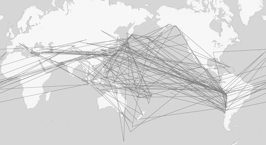
I didn't put the arrows on as that has to be done manually.
starts at Rhodes and finishes at Near Coast of Central Chile
I think there would be too many 7's in 50 years to make anything less than a birdsnest
I will have a try
edit;
here is one I did last night, mag 8's 314-2015, 200 lines (events)
I didn't put the arrows on as that has to be done manually.
starts at Rhodes and finishes at Near Coast of Central Chile
I think there would be too many 7's in 50 years to make anything less than a birdsnest
I will have a try
edit;
edit on 1100000032932916 by muzzy because: (no reason given)
a reply to: wasobservingquietly
Not very long, its a variation on the GPS Visualizer form that creates the maps with the icons on them, instead of icons it joins each lat/long location with a line.
I got the data for them from ANSS, they have the quickest search form.
I did this before a few years back when I thought I seen a sequential trend, but after a few days working on it it just turned out to be totally random, there is no way to tell where the next line will head to.
I does look cool though.
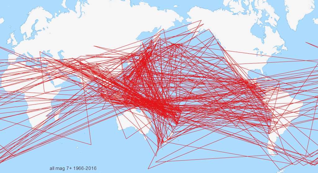
Another variation, which is right back to where I started with GPS Visualizer, even before I made my own icons was this.
The Plots are given numbers.
But it is hard to read some of the numbers, because they are so close together.
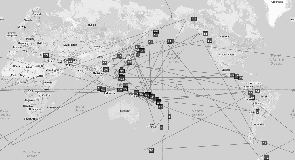
Not very long, its a variation on the GPS Visualizer form that creates the maps with the icons on them, instead of icons it joins each lat/long location with a line.
I got the data for them from ANSS, they have the quickest search form.
I did this before a few years back when I thought I seen a sequential trend, but after a few days working on it it just turned out to be totally random, there is no way to tell where the next line will head to.
I does look cool though.
Another variation, which is right back to where I started with GPS Visualizer, even before I made my own icons was this.
The Plots are given numbers.
But it is hard to read some of the numbers, because they are so close together.
a reply to: muzzy
Just read about a 6.7 hitting the Xinjiang province of China.
1 dead, so far.
Oddly, officials in that same province just within the last few days, demanded that all citizens turn in their passports to the officials, effectively cutting off travel.
Just read about a 6.7 hitting the Xinjiang province of China.
1 dead, so far.
Oddly, officials in that same province just within the last few days, demanded that all citizens turn in their passports to the officials, effectively cutting off travel.
NZ rocking in the north now
East Cape Ridge again
Public ID 2016p894629
Intensity moderate
Universal Time November 27 2016, 0:18:39
NZ Daylight Time Sun, Nov 27 2016, 1:18:39 pm
Depth 61 km
Magnitude 5.1
Location 105 km north-east of Te Araroa
Latitude, Longitude -37.08, 179.31
www.geonet.org.nz...
It never stopped there on East CApe, but the offshore ones died away for quite a while.
also yesterday
Public ID 2016p892721
Intensity severe
Universal Time November 26 2016, 7:21:42
NZ Daylight Time Sat, Nov 26 2016, 8:21:42 pm
Depth 13 km
Magnitude 5.1
Location 35 km north of Wairoa
Latitude, Longitude -38.72, 177.46
www.geonet.org.nz...
947 felt reports
my partner thought she felt that one
Porangahau and Cape Turnagain on the lower Hawkes Bay area still swarming (slow quake they say)
I'm going to have to do a page on that one, its too important not to. The maps are created using GPS stations , not seismographs, so its not really something I am able to download the raw data for.
I first mentioned it on the 22nd
latest slip map
I just spent an hour reading up on the GPS data from Geonet, I think I kind of "get it"
here is the page.
by writing a query you can get a graph plot form each station or multiple stations.
As a test/example I have taken KAPT (Kapiti) which is just offshore from me on the West Caost, and PORA (Porangahau) over on the East Coast where the swarm is happening.
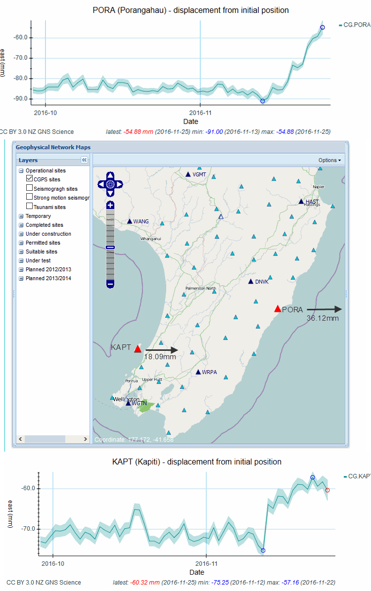
(I marked the map, those are not official Geonet measurements)
From what I can gather from the 2 graphs is that Kapiti has moved (-75.25 minus -57.16) = -18.09mm east
and Porangahau has moved (-91 minus -54.88) = -36.12mm east
Is this how they work the shift out? I'm not sure, just being logical about it.
So the east coast is moving at twice the rate of the west coast,
surely this mean the Wairarapa is being stretched apart??
makes sense as the Wairarapa is a Graben anyway.
Could this mean Wairarapa is in for a sudden jolt? will it keep stretching then snap? or will it just keep getting wider and wider?
I must learn more about this GPS stuff, and how to go back and get graphs from Jan 2014 when the Eketahuna 6.2 struck.
the more you look into this earthquake stuff the more questions there are.
East Cape Ridge again
Public ID 2016p894629
Intensity moderate
Universal Time November 27 2016, 0:18:39
NZ Daylight Time Sun, Nov 27 2016, 1:18:39 pm
Depth 61 km
Magnitude 5.1
Location 105 km north-east of Te Araroa
Latitude, Longitude -37.08, 179.31
www.geonet.org.nz...
It never stopped there on East CApe, but the offshore ones died away for quite a while.
also yesterday
Public ID 2016p892721
Intensity severe
Universal Time November 26 2016, 7:21:42
NZ Daylight Time Sat, Nov 26 2016, 8:21:42 pm
Depth 13 km
Magnitude 5.1
Location 35 km north of Wairoa
Latitude, Longitude -38.72, 177.46
www.geonet.org.nz...
947 felt reports
my partner thought she felt that one
Porangahau and Cape Turnagain on the lower Hawkes Bay area still swarming (slow quake they say)
Update: Saturday 26 November
As of Saturday 26th November, 225 earthquakes have been recorded in the Porangahau region since the Kaikoura Earthquake. Most of the earthquakes have been smaller than magnitude 3.
The Kapiti-Manawatu slow-slip event (my area)has involved movement across the Hikurangi subduction zone plate boundary of between 5-7cm, equivalent to a magnitude 6.8 earthquake in the last two weeks.
I'm going to have to do a page on that one, its too important not to. The maps are created using GPS stations , not seismographs, so its not really something I am able to download the raw data for.
I first mentioned it on the 22nd
latest slip map
edit on 1100000033033016 by muzzy because: (no reason given)
I just spent an hour reading up on the GPS data from Geonet, I think I kind of "get it"
here is the page.
by writing a query you can get a graph plot form each station or multiple stations.
As a test/example I have taken KAPT (Kapiti) which is just offshore from me on the West Caost, and PORA (Porangahau) over on the East Coast where the swarm is happening.
(I marked the map, those are not official Geonet measurements)
From what I can gather from the 2 graphs is that Kapiti has moved (-75.25 minus -57.16) = -18.09mm east
and Porangahau has moved (-91 minus -54.88) = -36.12mm east
Is this how they work the shift out? I'm not sure, just being logical about it.
So the east coast is moving at twice the rate of the west coast,
surely this mean the Wairarapa is being stretched apart??
makes sense as the Wairarapa is a Graben anyway.
Could this mean Wairarapa is in for a sudden jolt? will it keep stretching then snap? or will it just keep getting wider and wider?
I must learn more about this GPS stuff, and how to go back and get graphs from Jan 2014 when the Eketahuna 6.2 struck.
the more you look into this earthquake stuff the more questions there are.
edit on 1100000033033016 by muzzy because: (no reason
given)
Just had a "door rattler" here
4.5
35 km west
27km deep
www.geonet.org.nz...
I filled in a felt report and got a report page back
Reported Shaking
Extreme 16
Severe 13
Strong 158
Moderate 1,879
Light 5,117
Weak 3,649
Total 10,832
Hmm that differs from the official report on the Geonet page
Intensity Reports
extreme 9
severe 10
strong 120
moderate 1618
light 4528
weak 3135
Total 9420
4.8 Seddon 33 mins ago
www.geonet.org.nz...
4.1 Seddon 10 mins ago
www.geonet.org.nz...
they are coming in thick and fast
I'm going to do what 500,000+ people did after the 7.8 was over
go to bed
hey life goes on, its 10:30 pm here, back to work tomorrow
4.5
35 km west
27km deep
www.geonet.org.nz...
I filled in a felt report and got a report page back
Reported Shaking
Extreme 16
Severe 13
Strong 158
Moderate 1,879
Light 5,117
Weak 3,649
Total 10,832
Hmm that differs from the official report on the Geonet page
Intensity Reports
extreme 9
severe 10
strong 120
moderate 1618
light 4528
weak 3135
Total 9420
edit on 1100000033133116 by muzzy because: (no reason given)
4.8 Seddon 33 mins ago
www.geonet.org.nz...
edit on 1100000033133116 by muzzy because: (no reason given)
4.1 Seddon 10 mins ago
www.geonet.org.nz...
they are coming in thick and fast
edit on 1100000033133116 by muzzy because: posted original 44 mins ago, have edited twice
I'm going to do what 500,000+ people did after the 7.8 was over
go to bed
hey life goes on, its 10:30 pm here, back to work tomorrow
edit on 1100000033133116 by muzzy because: (no reason given)
F-E Region: Poland
Time: 2016-11-29 20:09:42.0 UTC
Magnitude: 4.5 (mb)
Epicenter: 16.11°E 51.49°N
Depth: 1 km
Status: A - automatic
geofon.gfz-potsdam.de...
I didn't quite catch the full story on the truck radio, they mentioned something about Mines
Time: 2016-11-29 20:09:42.0 UTC
Magnitude: 4.5 (mb)
Epicenter: 16.11°E 51.49°N
Depth: 1 km
Status: A - automatic
geofon.gfz-potsdam.de...
I didn't quite catch the full story on the truck radio, they mentioned something about Mines
originally posted by: muzzy
a reply to: HollywoodFarmGirl
here is one I did last night, mag 8's 314-2015, 200 lines (events)
I didn't put the arrows on as that has to be done manually.
starts at Rhodes and finishes at Near Coast of Central Chile
I think there would be too many 7's in 50 years to make anything less than a birdsnest
I will have a try
edit;
That would be cool if you could "sort" things by date / time, fading from one color to others. Then you could easily see the evolution of things, I'd think.
a reply to: paradoxious
Holy crap, I've been thinking the same thing, but felt I'd...sort of received "enough" of Muzzy's time towards this. But YES, I was wondering if that sort of shading/coloring would allow us to follow where the "ripple affect" might be, if there were to be one, so to speak.
It seems to my naked eye that the EQs bounce very much "back and forth", eh? Like, I see that "nest" Muzzy described with all 50 years graphed, but within that zig-zag "nest", I'm not finding any "blocks" where the zig didn't zag very far.... or places where it looks like all at one time, a bunch of EQs were just "pooped out a pile".
(I apologize for my elementary vocabulary. I just hung out with my 10 year old son for an entire afternoon, and I seem to be coming up short with my more 'scholarly' language skills.)
I have the option to colorize by Time which is what you are suggesting, but I can't seem to get it to work. Maybe too many points
My suggestion about the lack of "blocks" may be due to balance, because we are in an Orb.
My suggestion about the lack of "blocks" may be due to balance, because we are in an Orb.
edit on 1100000033433416 by muzzy because: (no
reason given)
Greetings and salutations Quake Watch, I'd hope for the participation of some of the more technically minded of the regulars to this thread over
here:
Seismographs detect strange disturbance all across North America?
As always, much appreciation and gratitude to everyone for the consistent updates and discussion.
Seismographs detect strange disturbance all across North America?
As always, much appreciation and gratitude to everyone for the consistent updates and discussion.
a reply to: muzzy
Situated in a traditional mining region, the town is part of the largest industrial copper-extraction area in Poland, with a copper-processing plant operating nearby Polkowice Wiki
4 Miners dead
www.theguardian.com...
Situated in a traditional mining region, the town is part of the largest industrial copper-extraction area in Poland, with a copper-processing plant operating nearby Polkowice Wiki
4 Miners dead
www.theguardian.com...
a reply to: jadedANDcynical
I just read that thread and TA is saying it should be in the hoax bin? I don't know what to think about it really.
I just read that thread and TA is saying it should be in the hoax bin? I don't know what to think about it really.
a reply to: MamaJ
Another poster was suggesting it go in the hoax bin based on TAs agreeing (muzzy too, btw) with my assessment that the signals the person in the YouTube video was concerned over were, in fact, due to telemetry error.
The events described did happen, they just did not have the import being ascribed to them.
a reply to: jadedANDcynical
The thread is full of all kinds of wild theories now even though 3 of us nailed it on page 2. Probably best to just ignore the thread or leave it to the nutters.
Someone suggested it was a recalibration of the seismos, but from memory that's just a straight up and down vertical line then nothing at all for up to half a day.
F-E Region: Southern Peru
Time: 2016-12-01 22:40:26.5 UTC
Magnitude: 6.2 (Mw)
Epicenter: 70.66°W 15.21°S
Depth: 10 km
Status: C - confirmed
geofon.gfz-potsdam.de...
Time: 2016-12-01 22:40:26.5 UTC
Magnitude: 6.2 (Mw)
Epicenter: 70.66°W 15.21°S
Depth: 10 km
Status: C - confirmed
geofon.gfz-potsdam.de...
We are feeling some very light tremors here in Waikanae on the Kapitistan Coast, in the last hour 7:30 -8:45pm NZDT, barely recognizable as quakes,
but we are watching TV and both looked at each other and said the same thing at the same time "did you feel that?""
There is nothing on Geonet except M2's near Seddon during the period, and there is no traffic on the road.
I thought I would record it here, just in case we get hit by a big one tonight.
It could possibly be the Kapiti Slow Slip as well.
There is nothing on Geonet except M2's near Seddon during the period, and there is no traffic on the road.
I thought I would record it here, just in case we get hit by a big one tonight.
It could possibly be the Kapiti Slow Slip as well.
edit on 1200000033633616 by muzzy because: (no reason given)
new topics
-
President BIDEN's FBI Raided Donald Trump's Florida Home for OBAMA-NORTH KOREA Documents.
Political Conspiracies: 46 minutes ago -
Maestro Benedetto
Literature: 2 hours ago -
Is AI Better Than the Hollywood Elite?
Movies: 2 hours ago -
Las Vegas UFO Spotting Teen Traumatized by Demon Creature in Backyard
Aliens and UFOs: 5 hours ago -
2024 Pigeon Forge Rod Run - On the Strip (Video made for you)
Automotive Discussion: 6 hours ago -
Gaza Terrorists Attack US Humanitarian Pier During Construction
Middle East Issues: 7 hours ago -
The functionality of boldening and italics is clunky and no post char limit warning?
ATS Freshman's Forum: 8 hours ago -
Meadows, Giuliani Among 11 Indicted in Arizona in Latest 2020 Election Subversion Case
Mainstream News: 8 hours ago -
Massachusetts Drag Queen Leads Young Kids in Free Palestine Chant
Social Issues and Civil Unrest: 9 hours ago -
Weinstein's conviction overturned
Mainstream News: 10 hours ago
top topics
-
Krystalnacht on today's most elite Universities?
Social Issues and Civil Unrest: 12 hours ago, 9 flags -
University of Texas Instantly Shuts Down Anti Israel Protests
Education and Media: 14 hours ago, 8 flags -
Supreme Court Oral Arguments 4.25.2024 - Are PRESIDENTS IMMUNE From Later Being Prosecuted.
Above Politics: 11 hours ago, 8 flags -
Gaza Terrorists Attack US Humanitarian Pier During Construction
Middle East Issues: 7 hours ago, 7 flags -
Weinstein's conviction overturned
Mainstream News: 10 hours ago, 7 flags -
Massachusetts Drag Queen Leads Young Kids in Free Palestine Chant
Social Issues and Civil Unrest: 9 hours ago, 6 flags -
President BIDEN's FBI Raided Donald Trump's Florida Home for OBAMA-NORTH KOREA Documents.
Political Conspiracies: 46 minutes ago, 5 flags -
Meadows, Giuliani Among 11 Indicted in Arizona in Latest 2020 Election Subversion Case
Mainstream News: 8 hours ago, 5 flags -
Las Vegas UFO Spotting Teen Traumatized by Demon Creature in Backyard
Aliens and UFOs: 5 hours ago, 4 flags -
Chris Christie Wishes Death Upon Trump and Ramaswamy
Politicians & People: 12 hours ago, 2 flags
active topics
-
Massachusetts Drag Queen Leads Young Kids in Free Palestine Chant
Social Issues and Civil Unrest • 12 • : SchrodingersRat -
University of Texas Instantly Shuts Down Anti Israel Protests
Education and Media • 241 • : cherokeetroy -
Supreme Court Oral Arguments 4.25.2024 - Are PRESIDENTS IMMUNE From Later Being Prosecuted.
Above Politics • 79 • : WeMustCare -
SETI chief says US has no evidence for alien technology. 'And we never have'
Aliens and UFOs • 73 • : SchrodingersRat -
Is AI Better Than the Hollywood Elite?
Movies • 5 • : 5thHead -
New whistleblower Jason Sands speaks on Twitter Spaces last night.
Aliens and UFOs • 62 • : pianopraze -
Alternate Electors vs Fake Electors - What is the Difference.
2024 Elections • 115 • : WeMustCare -
Sunak spinning the sickness figures
Other Current Events • 24 • : NoCorruptionAllowed -
Nearly 70% Of Americans Want Talks To End War In Ukraine
Political Issues • 95 • : Irishhaf -
Meadows, Giuliani Among 11 Indicted in Arizona in Latest 2020 Election Subversion Case
Mainstream News • 14 • : WeMustCare