It looks like you're using an Ad Blocker.
Please white-list or disable AboveTopSecret.com in your ad-blocking tool.
Thank you.
Some features of ATS will be disabled while you continue to use an ad-blocker.

Quake Watch 2016
page: 76share:
Tsunami Vid.
Not big but you can really see the power of the water once it hits a solid object.
Damn I can't get it to embed
try this
www.youtube.com...
Not big but you can really see the power of the water once it hits a solid object.
Damn I can't get it to embed
try this
www.youtube.com...
edit on 1100000031831816 by muzzy because: (no reason given)
It can't be stressed how important the link between islands is, I got this directly from the Freight company I deal with bringing supplies to me.
"Last night KiwiRail managed to commission the Link Span (ramp) in Wellington for Road loading/unloading vehicles only onto/off Inter-Islander ferries. Rail wagons remain out of the question at this time.
An overnight survey confirms damage to rail lines in the Seddon and Kaikoura districts on the Picton to Christchurch line are severe. It is estimated a repair timeline will be measured in months, making this route inoperable for some time.
A freight shuttle service between Christchurch and Spring Creek Blenheim and vice-versa is being commissioned in the next 24 hours to bridge freight to a pop-up depot to load and unload containers at Spring Creek for shuttling onto and off Cook Strait sailings.
It has been reported by KiwiRail that they are investigating an option to commission direct services between Wellington and Lyttelton with the ferry "Kaitaki".
Options;
1. Coastal 7-9 days transit
2. Road/Rail to Wellington 5-6 days via Lewis Pass (dependent on
access)
3. Road /Rail to Wellington 6-7 days via Arthur's Pass (dependent on
access)
4. Road/Rail to Wellington 5-6 days via a ferry being diverted
directly into Lyttelton (not a tangible option at this time)"
I have postponed the project that the materials I was waiting for from Christchurch were for indefinitely, the weather is crap as well anyway and I wouldn't be doing it this week that's for sure.
Another aftershock just now, wobbling
5.8 Kaikoura
Geez Geonet are getting fast
by the time I posted here on ATS, and it was still wobbling, the quake was up on their page by the time I opened it a new tab
By the time I filled in the Felt Report there were 4500 felt reports already
12% chance of another M7+ according to the models
and another, 5.2 Seddon
www.geonet.org.nz...
Summary so far @ 15/11/2016 15:43:57NZDT, (15/11/2016 02:43:57UTC)
mag~1= 0 , mag1= 0 , mag2= 165 , mag3= 667 , mag4= 265 , mag5= 41 , mag6= 2 , mag7= 1, total= 1,141, total energy released= 3,119,854 TTNT
5.8 Kaikoura
Geez Geonet are getting fast
by the time I posted here on ATS, and it was still wobbling, the quake was up on their page by the time I opened it a new tab
By the time I filled in the Felt Report there were 4500 felt reports already
12% chance of another M7+ according to the models
edit on 1100000031831816 by muzzy because: (no reason given)
and another, 5.2 Seddon
www.geonet.org.nz...
edit on 1100000031831816 by muzzy because: (no reason given)
Summary so far @ 15/11/2016 15:43:57NZDT, (15/11/2016 02:43:57UTC)
mag~1= 0 , mag1= 0 , mag2= 165 , mag3= 667 , mag4= 265 , mag5= 41 , mag6= 2 , mag7= 1, total= 1,141, total energy released= 3,119,854 TTNT
edit on 1100000031831816 by muzzy because: (no reason given)
I really don't get how the internet traffic thingy works, how some pages go "viral" while others struggle to get a dozen hits.
You would think that my New Zealand Earthquakes 2016 blog pages would draw some readers after the 7.5 here, I was expecting hundreds of views just based on people googling the words in the title, but what a dissapointment.
just looking at the overview stats on my blog this morning
on the 12th Nov, the day before the 7.5 I had 95 views, this was up from the average 20 per day when nothing is happening.
On that day people read the posts;
16.07.2016 (16), 26.10.2016 (15), 14.03.2016 (13), 03.07.2016 (12), 22.10.2016 (11) and so on down
on the 13th (the day of the 7.5) I got 28 readers, yesterday 14 and today so far 13
Given that my maps are more comprehensive than what Geonet puts out (the best map they have just shows the last 100, 500, 1000 etc) I expected more views than what I'm getting.
Source countries have remained the same as they always have, in the last week;
New Zealand 147
United States 21
Russia 17
France 7
ATS 6
I have been trying to update the daily pages in the last 3 days about 4 times a day, to keep people informed, I can only do this because the weather is lousy and I'm stuck at home, but I think I am wasting my time.
There is a new page up since last night Hope Fault-Cape Campbell 7.5 of 13 Nov 2016UTC and aftershocks, but I'm not going to bother busting my ass to keep it updated.
edit on 1100000031931916 by muzzy because: (no reason given)
a reply to: muzzy
Three cows trapped by New Zealand earthquake – now how do we get them down?
Video and Image
Found it on YT
Three cows trapped by New Zealand earthquake – now how do we get them down?
Three cows somehow survived an earthquake in New Zealand after their field was destroyed leaving them stranded on a tiny patch of grass.
The two adult cattle and one calf were spotted via helicopter trapped on the small island that was created after the 7.8 magnitude earthquake struck close to the small town of Kaikoura.
Video and Image
Found it on YT
edit on 15/11/2016 by PuterMan because: (no reason given)
land uplifted, stranded boat and sea life
www.stuff.co.nz...
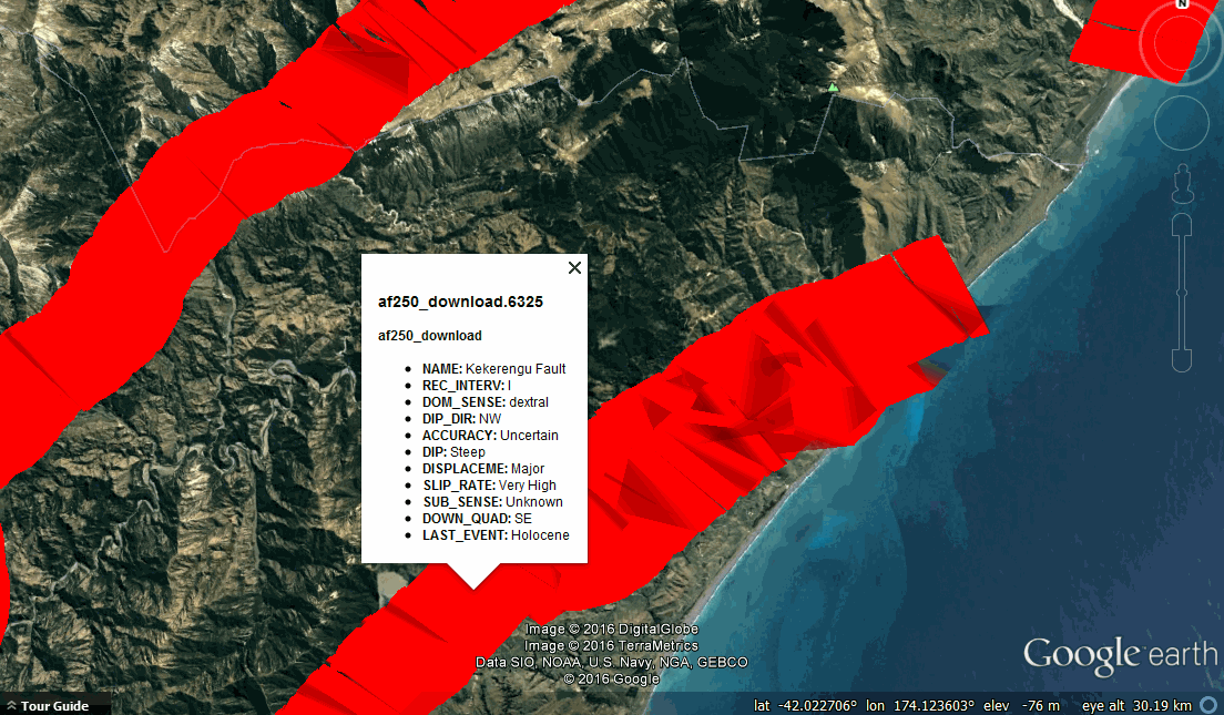
this is interesting, Geonets latest thoughts on the situation
Kekerengu Fault at the coast - appears to have had up to 10m of slip
Newly identified fault at Waipapa Bay
Hope Fault - seaward segment - minor movement
Hundalee Fault
info.geonet.org.nz...
BTW that KML file I posted a few days back with the NZ Faults ... link again
It is an overlay, I thought it was just an image, but if you have it open in Google Earth and zoom in quite close there is more detail and clicking on the thicker Red band of each section of fault brings up some text. You have to zoom out then back in again if you want to move down the fault and get the detail. The broad clickable bands seem to only work from 37km height level downwards.
Handy when referring to the Faults Geonet mention in the link above.
www.stuff.co.nz...
this is interesting, Geonets latest thoughts on the situation
Kekerengu Fault at the coast - appears to have had up to 10m of slip
Newly identified fault at Waipapa Bay
Hope Fault - seaward segment - minor movement
Hundalee Fault
info.geonet.org.nz...
BTW that KML file I posted a few days back with the NZ Faults ... link again
It is an overlay, I thought it was just an image, but if you have it open in Google Earth and zoom in quite close there is more detail and clicking on the thicker Red band of each section of fault brings up some text. You have to zoom out then back in again if you want to move down the fault and get the detail. The broad clickable bands seem to only work from 37km height level downwards.
Handy when referring to the Faults Geonet mention in the link above.
edit on 1100000031931916 by muzzy because: (no reason given)
I have noticed a lot of the aftershocks we are feeling here in the lower north island are double taps, like one we felt at 8:03 was a 4. 7 at Kaikoura
then 24 seconds later a 4.8 at Cook Strait off Cape Campbell, this may explain why they seem to be long quakes.
Edit: well maybe not, just checked again and the Kaikoura one has been downgraded to 2.7, we wouldn't feel that being so far away
On another note just listening to the radio there is talk from the local council to maybe install tsunami sirens here
My God how useless are these @#$€% beauracrats, time for talk is long past
Edit: well maybe not, just checked again and the Kaikoura one has been downgraded to 2.7, we wouldn't feel that being so far away
edit on 1100000031931916 by muzzy because: (no reason given)
On another note just listening to the radio there is talk from the local council to maybe install tsunami sirens here
My God how useless are these @#$€% beauracrats, time for talk is long past
edit on 1100000031931916 by muzzy because: (no reason
given)
further to: muzzy
Another problem..... Google again, Google Earth this time.
I'm not sure if it is something I changed but since the 4th Nov JST all the times on the japan event tags on my maps have been UTC, its not picking up the JST conversion. Prior to that it was all good.
The columns are marked
Date/Time JST
and
Date/Time UTC
Not only that, the UTC in the lower entry of the tag is in _-_ - 2016 format, rather than _/_/2016 which is the way it has been for years.
I just did a test and took out the Date/Time part of the header and it works OK, like it did before.
Its like the GPS Visualiser program just sees 2 x Date/Time and the space but can't see the JST or UTC difference on the end so just uses the Tag title which I set at UTC.
Not sure what happened, damn, everything I have done on Japan since the 3rd Nov is out of whack, incl a Tottori and a big Kumamoto update at the weekend.
Its easy enough to fix my templates, just a hassle of having to run them through again for 12 days worth of maps.
Its only japan, the NZ codes for showing both times seems to work alright.
Here is an unusual one, on the West Coast of S. Korea
japanquakes.blogspot.co.nz...
3.6-13/11/2016 12:52:59UTC
Lat/Long: 36.362, 126.612;
JST: 13/11/2016 21:52:59;
UTC: 13/11/2016 12:52:59;
Depth: 102;
Mag: 3.6 ML;
Location: S KOREAN PENINSULA REG;
Energy Released: 3.788 tonnes of TNT;
Source: JMA Status: reviewed
Also note that Tottori seems to be easing off, at least the 15th JST shows so
edit on 1100000032032016 by muzzy because: (no reason
given)
This one may be of concern,
it's on the South End of the Hope Fault away from all the recent activity
and it is only 32km from the Alpine Fault
Thats all we need is for that to go as well!
ID: 2016p866253 Network: geonet;
Status: automatic;
Date/Time NZST: 17/11/2016 00:19:45;
Date/Time UTC: 2016-11-16 12:19:45;
Latitude, Longitude: -42.76992, 171.88122;
Magnitude: 4.34;
Depth: 39.22 km;
Energy Released: 49.26 tonnes of TNT;
Location: Greymouth-Hokitika
nzeq2016.blogspot.co.nz...
reminds me about a month ago I posted here about a small swarm near Inchbonnie, at the time I didn't notice it was near the Hope Fault, who was to know eh, that might have been the warning that the Hope was about to break
www.abovetopsecret.com...
I may have to bring the GL Region "Greymouth-Hokitika" into the coverage area of the Hope Fault-Cape Campbell page, I can't remember why I set the Region's east border at Longitude 172, maybe it was just a nice round number and made a rectangle, possibly should have made it at the south end of the Hope Fault, at Inchbonnie Long 171.74.
I might do that tomorrow, Geonet have adopted USGS's magnitude of 7.8Mw now, just like they did with the 2009 Dusky Sound. Excuse is that for big quakes the readings from further away are more accurate as the local seismographs get saturated and hard to decipher.
Starting to get a bit of a wave pattern in the aftershock graph now as time moves on, there is a 4.9ish about every 11-12 hours that creates a peak then it falls down for a while then climbs again until the next 4.9 etc etc
dl.dropboxusercontent.com...
it's on the South End of the Hope Fault away from all the recent activity
and it is only 32km from the Alpine Fault
Thats all we need is for that to go as well!
ID: 2016p866253 Network: geonet;
Status: automatic;
Date/Time NZST: 17/11/2016 00:19:45;
Date/Time UTC: 2016-11-16 12:19:45;
Latitude, Longitude: -42.76992, 171.88122;
Magnitude: 4.34;
Depth: 39.22 km;
Energy Released: 49.26 tonnes of TNT;
Location: Greymouth-Hokitika
nzeq2016.blogspot.co.nz...
reminds me about a month ago I posted here about a small swarm near Inchbonnie, at the time I didn't notice it was near the Hope Fault, who was to know eh, that might have been the warning that the Hope was about to break
www.abovetopsecret.com...
edit on 1100000032032016 by muzzy because: (no reason given)
I may have to bring the GL Region "Greymouth-Hokitika" into the coverage area of the Hope Fault-Cape Campbell page, I can't remember why I set the Region's east border at Longitude 172, maybe it was just a nice round number and made a rectangle, possibly should have made it at the south end of the Hope Fault, at Inchbonnie Long 171.74.
I might do that tomorrow, Geonet have adopted USGS's magnitude of 7.8Mw now, just like they did with the 2009 Dusky Sound. Excuse is that for big quakes the readings from further away are more accurate as the local seismographs get saturated and hard to decipher.
edit on 1100000032032016
by muzzy because: (no reason given)
Starting to get a bit of a wave pattern in the aftershock graph now as time moves on, there is a 4.9ish about every 11-12 hours that creates a peak then it falls down for a while then climbs again until the next 4.9 etc etc
dl.dropboxusercontent.com...
edit on 1100000032032016 by muzzy because: (no
reason given)
I might do that tomorrow, Geonet have adopted USGS's magnitude of 7.8Mw now, just like they did with the 2009 Dusky Sound. Excuse is that for big quakes the readings from further away are more accurate as the local seismographs get saturated and hard to decipher.
Todays estimate is;
Magnitude,
7.820379733Mw which is 8,109,198.36TTNT
Prior estimate was;
Magnitude,
7.5259ML , which is 2,932,637.10TTNT
huge huge difference in energy released
explains the coast lifting 1 metre along the Marlborough region
edit on 1100000032032016 by muzzy because: (no reason given)
Six faults affected in the New Zealand quakes.
Alot of energy released. Maybe that means things will be quiet for a while muzzy.
www.livescience.com...
Alot of energy released. Maybe that means things will be quiet for a while muzzy.
www.livescience.com...
a reply to: crappiekat
I don't think so.
"the potential for aftershocks of between 6.0 and 6.9 (95% within the next 30 days)"
"the potential for aftershocks ofbetween M7.0 to M7.8.(30% within the next 30 days)
the big question is, where?
Geonet forecast
Re the 1m uplift along the coast. On the TV news Wednesday they showed people rescuing Paua (Abalone) and returning them to the sea. A spokesperson came on and said the quota system is still in force ( 3 per person per day), then yesterday the Ministry of Agriculture came out and said they may enforce a total ban on fishing along the coast for Paua and Crayfish. News show thousands of Crayfish stranded on dry land hiding in the shade amongst the rocks.
I mean how mean can they get?, the Crays are going to die regardless, why not let people who may have lost their homes and are living in shelters get a free feed. @$#&%$^ bureaucrats
Wellington CBD has a lot of damaged buildings
www.stuff.co.nz...
I haven't been down there since the quake, the roads are chocked because of the traffic delays, landslides being cleared along the way down to single lane in some places, its just not worth the hassle, it's a 2 hour trip (usually 1hr) The roof I was doing down there the week before is on hold, luckily I have other work I can do here near home.
I see they are calling this the Kaikoura Quake.
I suppose because the centre of the aftershock series is there and because of the way it has been cut off from the rest of the country.
The actual 7.8 remains just north of Culverton
Summary of the aftershocks so far;
mag1= 14
mag2= 972
mag3= 1,268
mag4= 329
mag5= 44
mag6= 2
mag7= 1
total= 2,630
TTNT= 8,313,127.408
a lot of M3's
Cook 1330
Marlborough 1293
a reply to: muzzy
OMGosh! I had asked hubby if those looked like abalone! I wasn't sure because there wasn't anything in that picture for perspective except that kelp or whatever it was. We haven't had
any abalone for 37 years! What I wouldn't give
for some! Beam me over Scottie! Ha, ha!
And all those lobsters! We only eat lobster a couple of times year. Usually when there's a special or for our anniversary. It's pretty dear here!
The pictures of the landslide/slip along the coast,
Kaikoura I think it was, looks like if they try to clear it, a whole lot more is going to fall. Sure wouldn't want to be the people that will be working on it!
Thanks for all the work you put into Quake Watch
& all the frustration you have to endure to keep up with everything! We all appreciate it & are reading, even when we don't have time to comment!
Stay safe!
WOQ
I'm not a fan of Facebook at all, but found this from stuff.co.nz
New Gorge
and not sure if it's on the Web but the Army convoy that made it through the inland route to Kaikoura yesterday delivered, amongst other things, 10 tons of pet food. Geez thats a lot.
edit; heres the story www.stuff.co.nz...
also a few quotes that caught my interest on stuff;
yeah it does seem warmer since last Sunday (sarcasm about the shift north)
New Gorge
and not sure if it's on the Web but the Army convoy that made it through the inland route to Kaikoura yesterday delivered, amongst other things, 10 tons of pet food. Geez thats a lot.
edit; heres the story www.stuff.co.nz...
also a few quotes that caught my interest on stuff;
Fortunately, Cook Strait, with its offset faults, had acted like a barrier and halted the quake in its tracks, Gledhill said.
Wellington and the Kapiti Coast are now 2 to 6cm further north, Christchurch and Banks Peninsula have shifted 2cm south and some parts of the West Coast are now 10cm closer to Canterbury than they were.
www.stuff.co.nz...
yeah it does seem warmer since last Sunday (sarcasm about the shift north)
edit on 1100000032232216 by muzzy because: (no reason
given)
Nobody logged this one yet?
About an hour & a half ago.
6.4 in Argentina.
On the road, on my phone, so bare bones.
Figured something was getting pushy with all the activity in the Prince Edward Islands.
WOQ
About an hour & a half ago.
6.4 in Argentina.
On the road, on my phone, so bare bones.
Figured something was getting pushy with all the activity in the Prince Edward Islands.
WOQ
new topics
-
Any one suspicious of fever promotions events, major investor Goldman Sachs card only.
The Gray Area: 1 hours ago -
God's Righteousness is Greater than Our Wrath
Religion, Faith, And Theology: 5 hours ago -
Electrical tricks for saving money
Education and Media: 8 hours ago -
VP's Secret Service agent brawls with other agents at Andrews
Mainstream News: 9 hours ago -
Sunak spinning the sickness figures
Other Current Events: 10 hours ago -
Nearly 70% Of Americans Want Talks To End War In Ukraine
Political Issues: 10 hours ago
top topics
-
VP's Secret Service agent brawls with other agents at Andrews
Mainstream News: 9 hours ago, 9 flags -
Cats Used as Live Bait to Train Ferocious Pitbulls in Illegal NYC Dogfighting
Social Issues and Civil Unrest: 13 hours ago, 8 flags -
Electrical tricks for saving money
Education and Media: 8 hours ago, 4 flags -
Nearly 70% Of Americans Want Talks To End War In Ukraine
Political Issues: 10 hours ago, 3 flags -
Sunak spinning the sickness figures
Other Current Events: 10 hours ago, 3 flags -
Late Night with the Devil - a really good unusual modern horror film.
Movies: 12 hours ago, 2 flags -
The Good News According to Jesus - Episode 1
Religion, Faith, And Theology: 15 hours ago, 1 flags -
Any one suspicious of fever promotions events, major investor Goldman Sachs card only.
The Gray Area: 1 hours ago, 1 flags -
God's Righteousness is Greater than Our Wrath
Religion, Faith, And Theology: 5 hours ago, 0 flags
active topics
-
-@TH3WH17ERABB17- -Q- ---TIME TO SHOW THE WORLD--- -Part- --44--
Dissecting Disinformation • 659 • : Justoneman -
God's Righteousness is Greater than Our Wrath
Religion, Faith, And Theology • 7 • : andy06shake -
SETI chief says US has no evidence for alien technology. 'And we never have'
Aliens and UFOs • 58 • : Justoneman -
Nearly 70% Of Americans Want Talks To End War In Ukraine
Political Issues • 19 • : Consvoli -
Terrifying Encounters With The Black Eyed Kids
Paranormal Studies • 76 • : Consvoli -
Samuel Aun Woer
Religion, Faith, And Theology • 27 • : helebi20 -
Any one suspicious of fever promotions events, major investor Goldman Sachs card only.
The Gray Area • 2 • : Cavemannick -
HORRIBLE !! Russian Soldier Drinking Own Urine To Survive In Battle
World War Three • 35 • : twistedpuppy -
VP's Secret Service agent brawls with other agents at Andrews
Mainstream News • 42 • : 38181 -
The Acronym Game .. Pt.3
General Chit Chat • 7746 • : bally001