It looks like you're using an Ad Blocker.
Please white-list or disable AboveTopSecret.com in your ad-blocking tool.
Thank you.
Some features of ATS will be disabled while you continue to use an ad-blocker.

Stars Can't Be Seen from Outer Space
page: 12share:
bingo. It is the same reason we can't see stars during the day time. it must be pretty difficult to get out of the sun light in space. Nearly
impossible I imagine.
originally posted by: GaryN
a reply to: wildespace
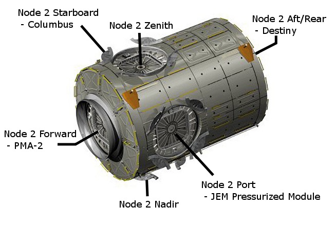
And that's after all the images and information I presented to you? The porthole in question is part of the zenith docking port on Node 2. It can be uncovered to look through it or to take pictures. Which has been done as part of the experiment to photograph the Moon.
The image in that video is NOT from a zenith porthole, you would not see any part of the space station if there was a porthole to look out of. The Earth is just out of sight below the space station.
Find me any reference to there being a window in the zenith port hatch, and then show me the image that was supposedly taken through it.
You have some bizarre ideas.
Well, I just don't drink of the NASA Kool-Aid, that stuff will rot your mind. And I don't drink alcohol either, just in case you were going to respond that I must be drunk! 8)
You are really starting to look like these guys
originally posted by: GaryN
a reply to: wildespace
And that's after all the images and information I presented to you? The porthole in question is part of the zenith docking port on Node 2. It can be uncovered to look through it or to take pictures. Which has been done as part of the experiment to photograph the Moon.
The image in that video is NOT from a zenith porthole
I wasn't talking about the image in the video. The guy being interviewed provides information about the zenith porthole window being used to photograph the Moon. Perhaps we'll get a chance to see and identify those particular images, but for now, the oral evidence is good enough. The images were taken by Terry Wirts, perhaps there's a way to contact him if you want to ask him what exactly did he do and where those images are.
Find me any reference to there being a window in the zenith port hatch, and then show me the image that was supposedly taken through it.
The video provides the reference, and the images I have posted in this thread do as well. I'll post the images again:
Second image actually shows that there are portholes in every docking hatch on that node, and that could be the case in all other American nodes.
A quick Google search just now produced a reference to the "Node 2 Zenith window flap": www.nasaspaceflight.com...
and to the "Node 2 Zenith hatch window": blogs.nasa.gov...
It exists, and its cover can be opened and closed.
P.S. you were even shown a photo in your thread at thunderbolts.info >_<
Googling images for "ISS Dragon Hatch" gives a lot of results where the porthole is visible.
edit on 28-5-2015 by wildespace because: (no
reason given)
a reply to: wildespace
Well it looks like you are technically correct wildespace, and I had asked on the nasaspaceflight forum about outward facing portholes, and the reply was:
They sure don't make it easy to find the info though, and it looks like they made TB remove my in-line image from this post
www.thunderbolts.info...
though the larger one is available:
forum.nasaspaceflight.com...
I don't think the crew can look out that porthole though, the BCS camera seems to be a permanent installation, maybe they can remove it, don't see that mentioned either though. But this to me begs more questions. If they can see deep space, then why not show us sunlight or moonlight streaming in through it? Why not do some astrophotography through it, the crew have lots of off duty time to fill, and some of them are keen amateur astronomers, must be frustrating not to be able to access the port. Maybe they have to keep it covered to stop the Suns brutal heat coming in and overloading the air conditioning system? Yeah, right....
Well it looks like you are technically correct wildespace, and I had asked on the nasaspaceflight forum about outward facing portholes, and the reply was:
" The only portholes on unused CBM ports that are currently NOT covered with a CBCS flap are the Node 2 nadir and zenith ports - so these are the only CBM hatch portholes that the crew can "see" out of (and there isn't really much to see out of the Node 2 zenith porthole - except the blackness of space). "
They sure don't make it easy to find the info though, and it looks like they made TB remove my in-line image from this post
www.thunderbolts.info...
though the larger one is available:
forum.nasaspaceflight.com...
I don't think the crew can look out that porthole though, the BCS camera seems to be a permanent installation, maybe they can remove it, don't see that mentioned either though. But this to me begs more questions. If they can see deep space, then why not show us sunlight or moonlight streaming in through it? Why not do some astrophotography through it, the crew have lots of off duty time to fill, and some of them are keen amateur astronomers, must be frustrating not to be able to access the port. Maybe they have to keep it covered to stop the Suns brutal heat coming in and overloading the air conditioning system? Yeah, right....
a reply to: GaryN
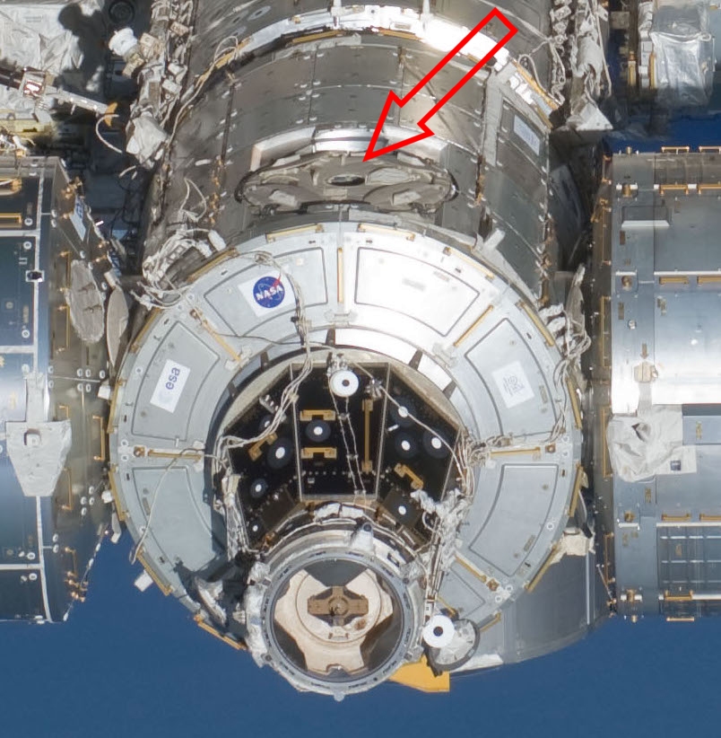
Here's the Node 2 (Harmony) zenith port:
And here's a photo taken of the moon from that port:
eol.jsc.nasa.gov...
The moon would have been at an altitude of about 72°. There are probably other shots in the series where the moon was even closer to 90°, I haven't gone through all of them.
Here's the Node 2 (Harmony) zenith port:

And here's a photo taken of the moon from that port:
eol.jsc.nasa.gov...

The moon would have been at an altitude of about 72°. There are probably other shots in the series where the moon was even closer to 90°, I haven't gone through all of them.
originally posted by: nataylor
a reply to: GaryN
Here's the Node 2 (Harmony) zenith port:
And here's a photo taken of the moon from that port:
eol.jsc.nasa.gov...
The moon would have been at an altitude of about 72°. There are probably other shots in the series where the moon was even closer to 90°, I haven't gone through all of them.
Excuse WHY IT IS NOT VALID from GaryN IN 3...2....
Excuse WHY IT IS NOT VALID from GaryN IN 3...2....
Does nobody here know how to use Celestia?
I used Starry Night Pro (similar software to Celestia) to confirm the altitude to the moon at the time the picture was taken and the location of the
ISS based on the listed nadir location.
What is Celestia telling you for an altitude measurement?
What is Celestia telling you for an altitude measurement?
originally posted by: GaryN
a reply to: wmd_2008
There is a clue here. You seem to be clueless.
eol.jsc.nasa.gov...
No. There is a focal length.
It doesn't give you the f-stop and exposure time.
Try taking a picture of the moon. Let us know what the settings are when you get one that isn't hideously over-exposed.
What exactly are you trying to prove here? That you can't take pictures of the moon in space?
@nataylor: 407Km altitude (the figure is recorded on the link provided by GaryN
originally posted by: GaryN
a reply to: wmd_2008
There is a clue here. You seem to be clueless.
eol.jsc.nasa.gov...
I used Stellarium. Given the "ISS nadir point" as the locaton, as well as the date and time the photo was taken, the Moon was at about 72 degrees above the horizon. That's only about 28 degrees from zenith.
On the other hand, the image shown in the video was taken at the time and location that placed it near the horizon, so this must've been the image they took from the Cupola or side-facing porthole.
edit on 29-5-2015 by wildespace because: (no reason given)
I see the problem. Are you using the built-in ISS location in Celestia? From the fresh copy of Celestia I downloaded, it's way off from the correct
location. The ephemeris for the ISS changes a lot because of it's subject to atmospheric drag, torque, and frequent reboosts. So the built-in data
is going to be outdated.
www.celestiamotherlode.net...
I based my measurements on the nadir location on the photo's info page. That tells you the ISS's position at the moment the photo was taken.
www.celestiamotherlode.net...
Question: The ISS doesn't appears at the correct position. What's wrong?
Answer:
The orbit of the ISS changes continuously in ways that are almost impossible to predict due to things like atmospheric drag, light pressure, cargo ship docking, etc. If you want an accurate orbit, you'll have to update it on a daily basis.
I based my measurements on the nadir location on the photo's info page. That tells you the ISS's position at the moment the photo was taken.
And here's the exposure info for that photo:
f/5.6, 1/2000 sec, ISO 400, exposure compensation of -0.3 EV.
f/5.6, 1/2000 sec, ISO 400, exposure compensation of -0.3 EV.
a reply to: nataylor
I just looked at he current ISS position and it matches the position of the ISS as shown in Celestia, so I don't think any variations in ISS orbit are going to affect things to that extent, but will look into that possibility.
I see the problem. Are you using the built-in ISS location in Celestia?
I just looked at he current ISS position and it matches the position of the ISS as shown in Celestia, so I don't think any variations in ISS orbit are going to affect things to that extent, but will look into that possibility.
a reply to: GaryN
With a default install of Celestia, setting the time to 15:43:14 UTC on 8-March-15, the ISS is just off the west coast of South America. It should be over the South Pacific, around Vanuatu.
Edit: And if for some reason you're showing the current position as of today correctly, it will not show the correct position on March 8. It's closer than the default install, but still not completely accurate.
edit on 29-5-2015 by nataylor because: (no reason given)
originally posted by: GaryN
a reply to: nataylor
I see the problem. Are you using the built-in ISS location in Celestia?
I just looked at he current ISS position and it matches the position of the ISS as shown in Celestia, so I don't think any variations in ISS orbit are going to affect things to that extent, but will look into that possibility.
In any case, the ISS's nadir location (pointing straight down to Earth) is stated for those images, so that's what I've used in Stellarium, in case you missed my post above
Here's a website that allows you to find the position of the ISS in the past: www.isstracker.com...
It downloads and stores the daily orbit information, so it will be correct for any past dates, unlike software like Celestia which uses one fixed set of orbital elements to calculate a position in the past.
It downloads and stores the daily orbit information, so it will be correct for any past dates, unlike software like Celestia which uses one fixed set of orbital elements to calculate a position in the past.
a reply to: nataylor
Well, I don't think I'm clueless, but I think you are probably much smarter than I am with this kind of thing. I appreciate your help, but am confused somewhat by the time given for the 2 images we have been looking at, as there is only 4 minutes between them, but the ground track would seem to indicate it should have been quite a lot longer, which obviously affects the Moons observed position. What am I misunderstanding?
OOPs, 2 hours and 4 minutes difference.
In any case, the ISS's nadir location (pointing straight down to Earth) is stated for those images, so that's what I've used in Stellarium, in case you missed my post above
Well, I don't think I'm clueless, but I think you are probably much smarter than I am with this kind of thing. I appreciate your help, but am confused somewhat by the time given for the 2 images we have been looking at, as there is only 4 minutes between them, but the ground track would seem to indicate it should have been quite a lot longer, which obviously affects the Moons observed position. What am I misunderstanding?
OOPs, 2 hours and 4 minutes difference.
edit on 29-5-2015 by GaryN because: (no reason given)
new topics
-
What is the white pill?
Philosophy and Metaphysics: 40 minutes ago -
Mike Pinder The Moody Blues R.I.P.
Music: 1 hours ago -
Putin, Russia and the Great Architects of the Universe
ATS Skunk Works: 4 hours ago -
A Warning to America: 25 Ways the US is Being Destroyed
New World Order: 8 hours ago
top topics
-
President BIDEN's FBI Raided Donald Trump's Florida Home for OBAMA-NORTH KOREA Documents.
Political Conspiracies: 14 hours ago, 33 flags -
A Warning to America: 25 Ways the US is Being Destroyed
New World Order: 8 hours ago, 17 flags -
Is AI Better Than the Hollywood Elite?
Movies: 16 hours ago, 4 flags -
Mike Pinder The Moody Blues R.I.P.
Music: 1 hours ago, 3 flags -
What is the white pill?
Philosophy and Metaphysics: 40 minutes ago, 3 flags -
Maestro Benedetto
Literature: 16 hours ago, 1 flags -
Putin, Russia and the Great Architects of the Universe
ATS Skunk Works: 4 hours ago, 1 flags
active topics
-
So this is what Hamas considers 'freedom fighting' ...
War On Terrorism • 262 • : TheWoker -
Gaza Terrorists Attack US Humanitarian Pier During Construction
Middle East Issues • 63 • : ToneD -
Truth Social goes public, be careful not to lose your money
Mainstream News • 133 • : Astyanax -
New whistleblower Jason Sands speaks on Twitter Spaces last night.
Aliens and UFOs • 70 • : baablacksheep1 -
Meadows, Giuliani Among 11 Indicted in Arizona in Latest 2020 Election Subversion Case
Mainstream News • 19 • : Threadbarer -
President BIDEN's FBI Raided Donald Trump's Florida Home for OBAMA-NORTH KOREA Documents.
Political Conspiracies • 27 • : Threadbarer -
A Warning to America: 25 Ways the US is Being Destroyed
New World Order • 20 • : jidnum2 -
Putin, Russia and the Great Architects of the Universe
ATS Skunk Works • 16 • : CristianVictoria -
Alternate Electors vs Fake Electors - What is the Difference.
2024 Elections • 123 • : frogs453 -
Massachusetts Drag Queen Leads Young Kids in Free Palestine Chant
Social Issues and Civil Unrest • 17 • : ToneD