It looks like you're using an Ad Blocker.
Please white-list or disable AboveTopSecret.com in your ad-blocking tool.
Thank you.
Some features of ATS will be disabled while you continue to use an ad-blocker.

Volcano Watch 2015-2021
page: 8share:
Volcano Turrialba erupted at 05:10 a.m. local time on June 2 with its ash and smoke reaching 1,000 meters into the sky, some 70 kilometers east of capital city San Jose. The official volcano authority recorded the eruption as a major one, because what it spewed out were diversified and over its normal output. (Soundbite) GINO GONZALEZ, Volcanologist of Research Institute of Geological Sciences, Unviersity of Costa Rica "It is a large eruption, with different types of energies released. With an earthquake, the seismic energy merely changed into volcanic eruption. With more potential energy, it has swollen and thermal energy and even rocks came out." The gas and ash mainly moved to north, with significant effect expected in the Central Valley, where San Jose and other major cities are located. Turrialba has been very active so far in 2016, with its expulsion of ash, gas, steam and even stones once reaching 3,000 meters high at the most.
RSOE
Volcanic alert for Mexico's Popocatépetl volcano remains at 2nd phase yellow following increased activity
Web Cam Live
And she blew Mexico's Popocatépetl volcano wow
Good pics & video in this article.
strangesounds.org...
"These powerful vibrations were reported 15 minutes after the exhalation in the State of Mexico, Hidalgo and Queretaro."
Good pics & video in this article.
strangesounds.org...
"These powerful vibrations were reported 15 minutes after the exhalation in the State of Mexico, Hidalgo and Queretaro."
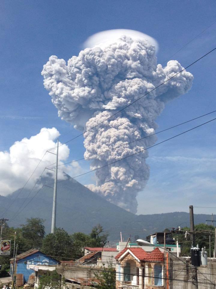
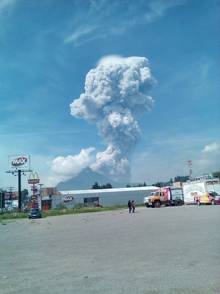
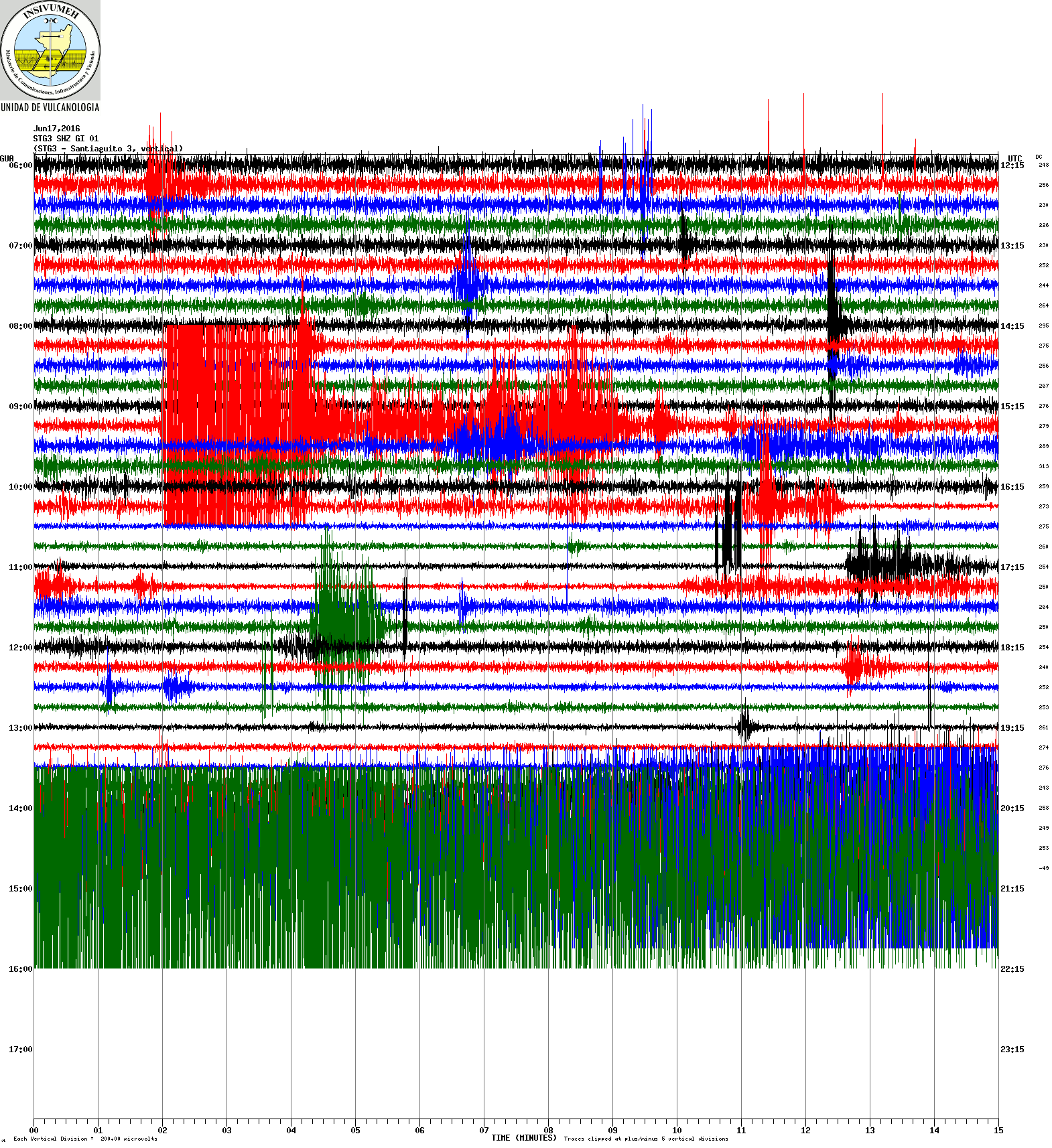
Eruption of the volcano santiaguito
edit on 17-6-2016 by lurksoften because: (no reason given)
a reply to: lurksoften
Looking at the Santiaguito helicorder, she seems to have just went off again.
Looking at the Santiaguito helicorder, she seems to have just went off again.
edit on 6/17/2016 by Olivine because: (no reason given)
It looks like what the helicorder above captured was a lahar. Be safe Guatemalan friends.
special bulletin
special bulletin
Experts have warned people to stay away from the Icelandic volcano Hekla - dubbed the "Gateway to Hell" - as the volcano could blow "at any minute". Experts say pressure is building up within the volcano, and an explosion could occur anytime, without warning. Iceland is located on a divergent tectonic plate boundary on the mid-Atlantic Ridge
Einarsson reveals that Hekla is showing pressure readings which are higher than they were during the eruptions in 1991 and 2000. In its last eruption, Hekla caused a pyroclastic flow, thereby producing a wall of gas and rock that reached 450 mph. Just 30 miles away from Hekla is located another active volcano - Eyjafjallajökull - which most recently erupted in 2010. The massive plume of volcanic ash produced after the blow went into the atmosphere, resulting in grounding of air traffic over Europe and a knock-on effect on international flights. The shut down of airspace from April 14 to 25 that year had left millions stranded around the world.
RSOE
Article from 2 days ago put its more into perspective that it could be over blown on what is being warned about. Just a thing to keep an eye on.
That’s why it is a little peculiar that Dr. Páll Einarsson of the University of Iceland warned people and airplanes to “stay away” from Iceland’s Hekla based on his interpretation of accumulated strain at the volcano. According to reports coming out of Iceland, Dr. Einarsson says that strain measured on these strain gauges is higher than it was prior to the 2000 eruption. Also, it has been 16 years since Hekla’s last eruption and, at least for a brief period from 1970-2000 (mind you, this is a very short time for the lifespan of any volcano), it was erupting about every 10 years. Put those together and he thinks that Hekla is ready for its next eruption, and it could happen soon.
Scientists also don’t have strain data going back further than the 2000 eruption of Hekla, so they don’t have a good baseline for understanding exactly how the strain changes before every eruption—just what happened prior to the 2000 event. That’s not to say that they shouldn’t expect something similar, but the data is somewhat scant.
Article
EQ Map for that area
Real Time Data comming from around Hekla
If you are into watching supervolcanos, a good one to watch right now is Lake Taupo New Zealand. Southern Hemisphere may/may not be in for something
BIG soon. It is releasing stress, not sure what will come of it. A few 5+ quakes from the crater over the past week or two.
a reply to: muzzy
I have to say, I am totally baffled right now. My apologies. It was on RSOE's AlertMap this week. There were several that registered up to the 5.? followed by several aftershocks all there in the crater/lake area. I'm actually shocked that it's not recorded anywhere. I don't typically follow the volcano/earthquake world anymore, I was looking for something else when I saw all the activity. At one point this week it showed that 11 of the 18 super volcanoes had "rattled" this month. 5 within the past few days with that one in particular catching my attention. Hadn't seen that before. I suppose disregard?? Maybe they decided it was nothing or a computer glitch and took it off? I have no idea. I had posted the heads up in the yellowstone thread and they left a message saying to post it here so I did. Guess I didn't realize you couldn't see anything past todays activity as far as all that went.
I have to say, I am totally baffled right now. My apologies. It was on RSOE's AlertMap this week. There were several that registered up to the 5.? followed by several aftershocks all there in the crater/lake area. I'm actually shocked that it's not recorded anywhere. I don't typically follow the volcano/earthquake world anymore, I was looking for something else when I saw all the activity. At one point this week it showed that 11 of the 18 super volcanoes had "rattled" this month. 5 within the past few days with that one in particular catching my attention. Hadn't seen that before. I suppose disregard?? Maybe they decided it was nothing or a computer glitch and took it off? I have no idea. I had posted the heads up in the yellowstone thread and they left a message saying to post it here so I did. Guess I didn't realize you couldn't see anything past todays activity as far as all that went.
a reply to: mrsdudara
When you see something like that it pays to check some other sources, RSOE try to do too much, and get a lot wrong (unreliable)
Taupo hasn't had a 5+ in over a year.
www.geonet.org.nz...
When you see something like that it pays to check some other sources, RSOE try to do too much, and get a lot wrong (unreliable)
Taupo hasn't had a 5+ in over a year.
www.geonet.org.nz...
ID: NIEDU20160625-281; Network: JMA;
Date/Time UTC: 25/06/2016 04:51:57;
Date/Time JST: 25/06/2016 13:51:57;
Latitude, Longitude: 36.818, 137.832;
Magnitude: 4.8ML;
Energy Released (TTNT): 239.0057 ;
Depth: 0km;
Location: SW NIIGATA PREF;
Status: Reviewed
japanquakes.blogspot.co.nz...
Not a major quake, so I haven't mentioned it on Quake Watch 2016.
What caught my eye was that of the 158 small events (aftershocks) within 10 hours, 126 of them (including the main shock) had a depth of 0 km.
Looking on Google Satellite view or on Google Earth the main shock location is at what appears to be an old landslide, but it is hard to tell for sure. Bing Birds Eye view doesn't show much as the ground is covered in snow on that format.
It may be volcanic related, only 21km from Niigata-Yakeyama volcano which has a current status of "Level 1 (Potential for increased activity)" www.jma.go.jp...
edit on 0600000017717716 by muzzy because: (no reason given)
a reply to: muzzy
currently the total is at 557 at SW Niigata
and that doesn't include about 80 across the invisible Prefecture border in Western Nagano, which I didn't include yet because that Pref. is quite big and there are other quakes going on on the other side which are not directly related, so that Pref. has to be sorted separately by Longitude.
This series has 164 duplicate Lat,Long combinations
SW Niigata page
originally posted by: muzzy
a reply to: muzzy
currently the total is at 557 at SW Niigata
and that doesn't include about 80 across the invisible Prefecture border in Western Nagano, which I didn't include yet because that Pref. is quite big and there are other quakes going on on the other side which are not directly related, so that Pref. has to be sorted separately by Longitude.
This series has 164 duplicate Lat,Long combinations
SW Niigata page
The size of the search area has been extended out to include 112 extra events in Northern Nagano Pref. to the east, however the whole aftershock area still does not extend more than 7km from the 4.8 main shock, and the extra energy released is no more than 0.22TTNT.
Total number of aftershocks is now 739.
The map now contains 249 duplicate Lat,Long combinations. This is a real PITA for us map makers. The only thing to do is make an animation of the series. I will work on that, now there are a few days down the track time wise.
edit on 0700000018918916 by muzzy because: (no reason
given)
originally posted by: sled735
a reply to: sled735
That article turned out to be something from 2014 that was re-circulated with the date removed.
Fear and doom porn!
you want some doom boards.dailymail.co.uk...
a reply to: muzzy
I gave up on the animation, uses too much data space. I gave it two shots, but at the end of the day it didn't show any patterns.
Same with the duplication's, 2nd review shows 238 duplication's now.
At an attempt for clarity I have added 0.001 to the Longitude of 2nd, 3rd and 4th duplication's. However even with that break apart some of the icons are still not clickable where icons overlap each other on the NZ Topo map as the zoom stops at 100ft/5metres scale. Bing Maps do zoom in closer, but I cannot show the whole series on one map due to the large number of events. I had to add the 0.0001 decimal place by hand for all 238 duplication's, I found them with Excel but still had to alter them one at a time. Maybe I could add 0.0002 to shift them fully apart at 5km scale, but would probably have to drop the 3rd and 4th duplicate by a further 0.0002 decimal places on the Latitude as well. What a PITA.
I never checked Hakone last year or Bardarbunga in 2014for this, probably thousands of duplication's on those ones too.
its because they are so confined, short 7km fault in Kazafuki's case.
edit on 0700000019019016 by muzzy because: speeeling
new topics
-
Big Storms
Fragile Earth: 50 minutes ago -
Where should Trump hold his next rally
2024 Elections: 3 hours ago -
Shocking Number of Voters are Open to Committing Election Fraud
US Political Madness: 4 hours ago -
Gov Kristi Noem Shot and Killed "Less Than Worthless Dog" and a 'Smelly Goat
2024 Elections: 5 hours ago -
Falkville Robot-Man
Aliens and UFOs: 5 hours ago -
James O’Keefe: I have evidence that exposes the CIA, and it’s on camera.
Whistle Blowers and Leaked Documents: 6 hours ago -
Australian PM says the quiet part out loud - "free speech is a threat to democratic dicourse"...?!
New World Order: 6 hours ago -
Ireland VS Globalists
Social Issues and Civil Unrest: 7 hours ago -
Biden "Happy To Debate Trump"
2024 Elections: 7 hours ago -
RAAF airbase in Roswell, New Mexico is on fire
Aliens and UFOs: 7 hours ago
top topics
-
A Warning to America: 25 Ways the US is Being Destroyed
New World Order: 17 hours ago, 21 flags -
Blast from the past: ATS Review Podcast, 2006: With All Three Amigos
Member PODcasts: 10 hours ago, 13 flags -
James O’Keefe: I have evidence that exposes the CIA, and it’s on camera.
Whistle Blowers and Leaked Documents: 6 hours ago, 12 flags -
Biden "Happy To Debate Trump"
2024 Elections: 7 hours ago, 12 flags -
Australian PM says the quiet part out loud - "free speech is a threat to democratic dicourse"...?!
New World Order: 6 hours ago, 12 flags -
Mike Pinder The Moody Blues R.I.P.
Music: 10 hours ago, 8 flags -
What is the white pill?
Philosophy and Metaphysics: 9 hours ago, 6 flags -
Shocking Number of Voters are Open to Committing Election Fraud
US Political Madness: 4 hours ago, 5 flags -
Ireland VS Globalists
Social Issues and Civil Unrest: 7 hours ago, 5 flags -
RAAF airbase in Roswell, New Mexico is on fire
Aliens and UFOs: 7 hours ago, 5 flags
active topics
-
Gov Kristi Noem Shot and Killed "Less Than Worthless Dog" and a 'Smelly Goat
2024 Elections • 34 • : cherokeetroy -
Ireland VS Globalists
Social Issues and Civil Unrest • 7 • : boatguy12 -
"We're All Hamas" Heard at Columbia University Protests
Social Issues and Civil Unrest • 292 • : TheWoker -
I am beholden to my truth, of which I share with you now.
Dreams & Predictions • 24 • : BrotherKinsMan -
Big Storms
Fragile Earth • 6 • : lilzazz -
Starburst galaxy M82 - Webb Vs Hubble
Space Exploration • 11 • : Arbitrageur -
Candidate TRUMP Now Has Crazy Judge JUAN MERCHAN After Him - The Stormy Daniels Hush-Money Case.
Political Conspiracies • 817 • : RazorV66 -
Post A Funny (T&C Friendly) Pic Part IV: The LOL awakens!
General Chit Chat • 7137 • : PorkChop96 -
Massachusetts Drag Queen Leads Young Kids in Free Palestine Chant
Social Issues and Civil Unrest • 21 • : ToneD -
Biden "Happy To Debate Trump"
2024 Elections • 49 • : TheMisguidedAngel