It looks like you're using an Ad Blocker.
Please white-list or disable AboveTopSecret.com in your ad-blocking tool.
Thank you.
Some features of ATS will be disabled while you continue to use an ad-blocker.

Strange radar images removed from Facebook
page: 2share:
Apparently, this happened several years ago, around the same time of year, and around the same area...
www.abovetopsecret.com...
www.abovetopsecret.com...
a reply to: ignorant_ape
How is it that the explanation of a glitch is undeniable regardless whether FB removed them. So, these are undeniably glitches now IYO? A 25-minute glitch of radar? Maybe, maybe not, but the case surely isn't solved because you say it's undeniably a glitch.
How is it that the explanation of a glitch is undeniable regardless whether FB removed them. So, these are undeniably glitches now IYO? A 25-minute glitch of radar? Maybe, maybe not, but the case surely isn't solved because you say it's undeniably a glitch.
originally posted by: Rezlooper
originally posted by: GoOfYFoOt
I don't see any "movement". I just see some RADAR sites showing returns and then more sites showing returns...Could you highlight the movement for us?
Here is from friend, just messaged me
"hey tell them wen we had clicked the play button on the weatherbug radar everything was moving BUT the circles they were statioinary. i just asked my friend that her and i seen this and she remember we hit play"
Right.
At the center of each "circle" is a NEXRAD or Doppler RADAR site connected to the network. Each circle is a separate image overlapped with the rest to show the whole area's weather...The circles are time-lapse recordings showing the reflectivity of precipitation or dense moisture in the atmosphere...
At the very end of the thread (last post) GoOfYFoOt posted, claims it is the result of electromagnetic storms.
From that thread ten years ago
The blobs in question in these photos though, they sure look like rain clouds or precipitation.
I've seen those kind of spots before. They are the result of an Electromagnetic Storm. The Earth's gravity grabs the storm rays bends them around to the opposite side of the planet where they make landfall.
The blobs in question in these photos though, they sure look like rain clouds or precipitation.
originally posted by: ignorant_ape
heres a idea for you :
did the uploader delete them himself to cause drama once the explaination that they were glitches was undeniable ?
BINGO! We have a winner.
They are not uncommon at all with doppler weather radar.
www.lakeeriewx.com...
Summary The weather pattern on November 6, 2007 was a classic scenario for the appearance of bright banding radar imagery. When combined with the discrete high elevation scans in a VCP 21, the result was a composite radar image that contained concentric bands of enhanced reflectivity. A bright band appeared in response to each radar beam scanning the melting level, observed on the sounding to be at approximately 5,000 feet. As the elevation of the scan increased, this bright band moved progressively closer to the radar station. At the four highest elevations (shown below), not only did the diameter of the bright band move closer to the station, the discrete nature of the scans produced very narrow rings of enhanced reflectivity.
and
www.srh.noaa.gov...
and
forgetomori.com...
Also discussed here.
www.abovetopsecret.com...
and
www.abovetopsecret.com...
edit on 16-9-2014 by hellobruce because: (no reason given)
a reply to: hellobruce
Okay, the expert has arrived. The expert at what? Thread derailment tactics. First, attack the source. Second, claim there's nothing to see here, 'It's common, no big deal."
I think we already figured out why the pics were removed and it may have been because the images violated T&C cuz the Humana image. Secondly, I don't know that these are common, maybe, "not unheard of," but I wouldn't go so far as to say these are common.
This guy is out there, but the video has some interesting parallels concerning "HAARP rings", as he calls them...
edit on 9/16/2014 by GoOfYFoOt because: (no reason given)
originally posted by: Rezlooper
a reply to: hellobruce
Okay, the expert has arrived. The expert at what? Thread derailment tactics. First, attack the source. Second, claim there's nothing to see here, 'It's common, no big deal."
Actually I have to agree with hellobruce for once. These anomalies are fairly common, I've seen at least 3 other threads discussing radar anomalies like this and I have a fairly large collection of radar anomaly images which I posted here.
oh dear -
no one has attacked anyone - except OOOP - you denouncing members as " thread derailers "
but on topic - if you or the face book crowd insist on remaining scientifically illiterate and denying that Doppler radars do this - then that's your problem - not ours
but FFS - don't wave your ignorance in public
your own post where you claim that " everything moves except the anomaly " is a big clue to what is happening - PS you get it half right - because the Doppler radar station does not move either
I am not going to spoon feed you - but googling doppler weather radar - will explain how it works and why these arcs appear on the live feed
a reply to: ChaoticOrder
Now those are some strange looking anomalies there, that's for sure. I haven't seen those before and thanks for bringing them to our attention. One thing about these images I have posted is that they actually look like rain. Not sure if that matters though.
Now those are some strange looking anomalies there, that's for sure. I haven't seen those before and thanks for bringing them to our attention. One thing about these images I have posted is that they actually look like rain. Not sure if that matters though.
a reply to: ignorant_ape
The first jab was the all-caps word bingo, followed by the assertion that the FB post was removed by poster in order to get attention. I'll leave it at that.
The first jab was the all-caps word bingo, followed by the assertion that the FB post was removed by poster in order to get attention. I'll leave it at that.
good to see someone capturing uncommon radar images regardless and since I've seen a handful of strange phantom faced ones+ over the last seven or so
years and another of a smiley face a child would've recognized and also about the same amount of years witnessing abnormal things in the clouds live
as well but each time I'd hoped at finding an archived image it was to no avail. What really fascinates is the idea of "He is coming with the clouds"
and from what I've seen, I wonder if there is some sort of literal attachment
www.abovetopsecret.com...
io9.com...
Strange Unnamed Clouds Appearing All Over The World
www.prisonplanet.com...
news.nationalgeographic.com...
www.abovetopsecret.com...
io9.com...
Strange Unnamed Clouds Appearing All Over The World
www.prisonplanet.com...
news.nationalgeographic.com...
edit on 17-9-2014 by Rustami because: (no reason
given)
edit on 17-9-2014 by Rustami because: (no reason given)
a reply to: Rezlooper
ah - now we see how your " logic " works :
you had no issue throwing out the unevidenced claim that farcebook " deleted them " as part of some conspiracy to suppress the " trooth "
have you googled " Doppler weather radar " yet ??
has it sunk in that these glitches are just glitches caused by the way the sustem works ???
as for my comment that it was a POSIBILITY that the uploader realised his error and deleted them to save face // create drama
well - iit happens
a reply to: Rezlooper
That was actually goofyfoot's post. No biggy... just giving credit where credit is due.
EDIT to ADD: Just seen your posts about Humana. That may be it then since the message I just referred to said he had an image that didn't belong to him. Maybe he has to crop that off the images and then repost them.
That was actually goofyfoot's post. No biggy... just giving credit where credit is due.
Doesn't military chaff cause goofy radar effects sometimes? I remember reading that somewhere here on ats.
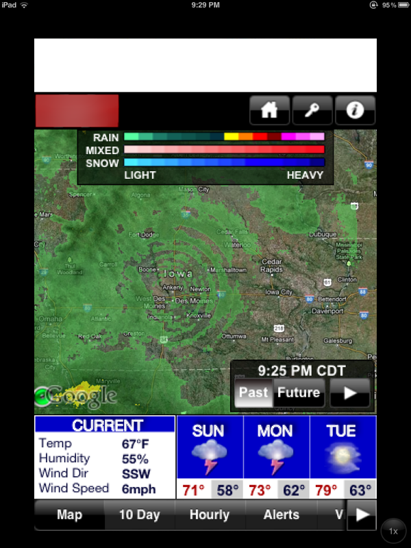
Oh, neat. I found one of these a while back when I was playing around with the weather radar app on my ipad. I figured it was just a glitch but my
brain immediately thought "HAARP!" so I took a screencap of it just for fun.
a reply to: PlasticWizard
Yes, Chaff shows on NEXRAD but it doesn't make rings. Rings are attributable to a number of things, including migrating birds.
a reply to: GoOfYFoOt
And yes, it's that time of year.
badbirdz2.wordpress.com...
www.njaudubon.org...
www.erh.noaa.gov...
Yes, Chaff shows on NEXRAD but it doesn't make rings. Rings are attributable to a number of things, including migrating birds.
a reply to: GoOfYFoOt
And yes, it's that time of year.
Migration is heating up across North America! With every night that passes, more and more birds are headed south.
badbirdz2.wordpress.com...
The information plate on the right side of the image shows dBZ values and corresponding birds/km3 values. Dr. S. A. Gauthreaux of Clemson University, used counts of nocturnal migrants observed flying across the disk of the full moon to produce a conversion from dBZ to birds/km3. Each pixel on the image represents a volume of space equal to one cubic kilometer.
Interestingly, NEXRAD cannot distinguish between different types of precipitation, or even if targets are precipitation, birds, insects, or dust. Reflectivity and other NEXRAD images however, contain many clues about the nature of radar echoes.
www.njaudubon.org...
By late August or early September, the martins begin their migration south, and then the roosting activity of other bird species nears its peak.
The unique doughnut pattern of these roost rings is the result of the martins departing their roosting site in all directions, roughly in equal densities. As they travel further from their roosting site and reach higher altitudes, they are detected by radar until they either rise above or drop below the radar beam.
www.erh.noaa.gov...
edit on 9/17/2014 by Phage because: (no reason given)
new topics
-
Judas Iscariot Slips The Hangman's Noose
Political Issues: 40 minutes ago -
Murder Suicide Investigation Still Active 4 months later?
Other Current Events: 1 hours ago -
A Shout-out To truthseeker45 Hoot Hoot
General Chit Chat: 2 hours ago -
Ooooh...it worked!!
Members: 5 hours ago -
New House GOP Bill To Send Pro Hamas College Law Breakers to Gaza for 6 Months
Social Issues and Civil Unrest: 7 hours ago -
Pentagon UFO Hunter Reveals What He Knows About Aliens: Nothing
Aliens and UFOs: 9 hours ago -
President Bidens Health is Declining Faster 5.8.2024 - He Should Stay Home.
2024 Elections: 10 hours ago -
Court of Appeals Agrees to Hear Trump Appeal to Flush Fani Willis
US Political Madness: 10 hours ago
top topics
-
Chris Cuomo, who pushed vaccine shots on CNN, admits Moderna vaccine destroyed his health
Mainstream News: 16 hours ago, 30 flags -
Court of Appeals Agrees to Hear Trump Appeal to Flush Fani Willis
US Political Madness: 10 hours ago, 15 flags -
Ooooh...it worked!!
Members: 5 hours ago, 11 flags -
President Bidens Health is Declining Faster 5.8.2024 - He Should Stay Home.
2024 Elections: 10 hours ago, 9 flags -
New House GOP Bill To Send Pro Hamas College Law Breakers to Gaza for 6 Months
Social Issues and Civil Unrest: 7 hours ago, 9 flags -
History Shows; Many Crisis Are Artificial I'm Order To Enslave People
Political Conspiracies: 16 hours ago, 7 flags -
Crocodile Reported in Water near a Buckinghamshire village in the UK
Pets: 14 hours ago, 6 flags -
A Shout-out To truthseeker45 Hoot Hoot
General Chit Chat: 2 hours ago, 4 flags -
Judas Iscariot Slips The Hangman's Noose
Political Issues: 40 minutes ago, 3 flags -
I "lost" a manuscript.
Rant: 13 hours ago, 3 flags
active topics
-
Pentagon UFO Hunter Reveals What He Knows About Aliens: Nothing
Aliens and UFOs • 9 • : introufo2 -
-@TH3WH17ERABB17- -Q- ---TIME TO SHOW THE WORLD--- -Part- --44--
Dissecting Disinformation • 881 • : daskakik -
Judas Iscariot Slips The Hangman's Noose
Political Issues • 4 • : WeMustCare -
Strange Humanoid-Shaped Object Captured On Film In The Skies Over California
Aliens and UFOs • 26 • : charlyv -
President Bidens Health is Declining Faster 5.8.2024 - He Should Stay Home.
2024 Elections • 21 • : WeMustCare -
Chinese scientists create new mutant Ebola strain with horror eye symptoms
Breaking Alternative News • 33 • : NorthOS -
New House GOP Bill To Send Pro Hamas College Law Breakers to Gaza for 6 Months
Social Issues and Civil Unrest • 75 • : cherokeetroy -
I "lost" a manuscript.
Rant • 11 • : BeTheGoddess2 -
Skinwalker Ranch and the Mystery 1.6GHz Signal
Aliens and UFOs • 154 • : charlyv -
Murder Suicide Investigation Still Active 4 months later?
Other Current Events • 0 • : ByeByeAmericanPie