It looks like you're using an Ad Blocker.
Please white-list or disable AboveTopSecret.com in your ad-blocking tool.
Thank you.
Some features of ATS will be disabled while you continue to use an ad-blocker.

MH370 missing (Part 2)
page: 10share:
originally posted by: qmantoo
I am still catching up this new thread but before I go, I want to post this stuff.
This post mentions the CHINESE identifying the seismic event quoted from a university in the south of China I believe.
I also seem to remember that pprune.org mentioned that it is possible to to fly with only 1 of the 3 generators working. As long as 1 is working, then the flight is not held up (I think thats what they said) by the pre-flight check.
I live in New Zealand, a country where almost all International flights are ETOPS. With ETOPS rules you don't take off without at least four operating generators. When I worked for Air NZ even domestic B733s were maintained to ETOPS standard since their domestic and international aircraft were used interchangably.
Therefore it is kind of disgusting to me that MH66 (Airbus 330) made an emergency landing on 24 March with both Left and Right engine generators U/S. It had to have taken off with one inoperative generator and sounds like it only had three. I am unfamiliar with the A330 whether they have a RAT like Boeings do, but landing on a RAT is real desperation flying. MH66 landed using their APU and no airliner should be reduced to that.
sy.gunson -BUT each transmission has a hex code in it which identifies the aircraft uniquely. There should be no doubt about the aircraft's identity.
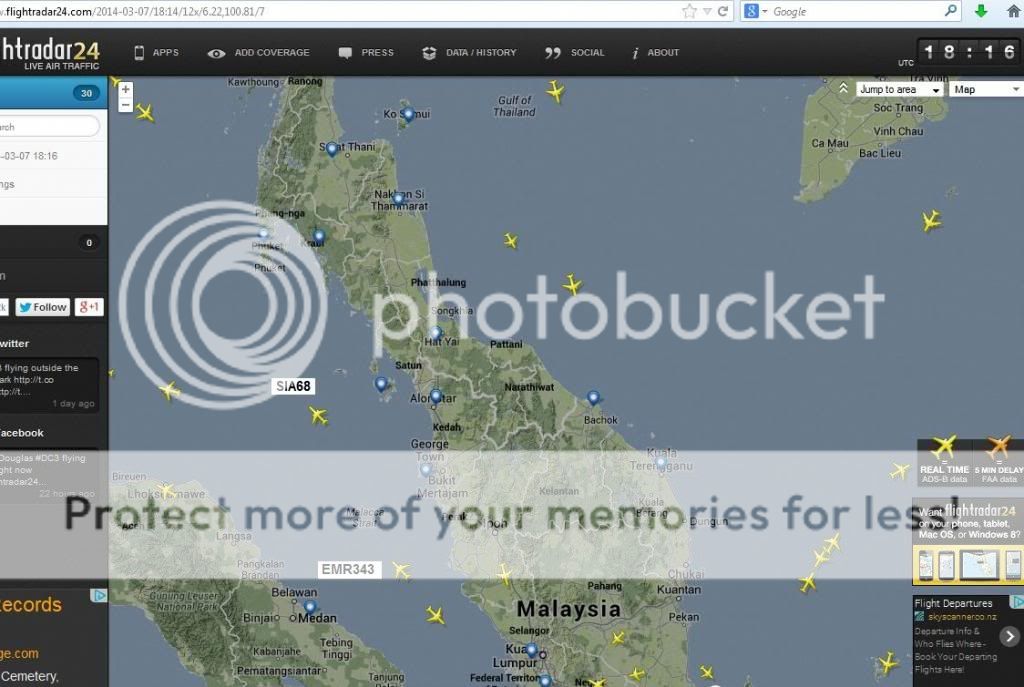
The aircraft believed to have been tracked in this image was EMR343.
You are talking about the transponder codes. Military radar at Butterworth does not detect transponder codes. This is what the Malaysian Air Force (RMAF) saw:

This is Flightradar24's version of what the Civilian radar saw.
Opens in a LINK
...Bearing in mind that a Boeing 777's maximum permitted speed below 10,000ft is 250 knots and maximum possible speed is 280knots with about ten times the fuel consumption at 35,000ft.
If it flew across the Indian Ocean at low altitude it would not make it half way to Sri Lanka.
As I have pointed out previously, it was often the practice to carry enough fuel for the return journey to/from China as the price of fuel is more expensive there. With MAS being in financial difficulty, it is more likely that the aircraft was carrying the extra fuel to save money. The Malaysian authorities would not want to offend China by admitting this publicly. This extra fuel may be one of the things which MAS are keeping out of the press.
It is so obvious that you've never been a pilot.
MH370 took off with 31,000 US gallons (69.5% full tanks) and was limited to 266,000kg take off weight by the length of runway.
You can't just take off with full fuel tanks and full payload. Most aircraft are incapable of that and even were that not the case you would need a runway halfway to the moon with full tanks.
In actual fact aircraft are not only limited by runway length, but also by the load bearing capacity of the runway/tarmac and even by the load bearing capacity of their structure and undercarriage.
If all you care about is creating a fantasy fiction novel then anything goes I suppose, but pilots live in the real world.
edit on 19-4-2014 by sy.gunson because: (no reason given)
originally posted by: earthling42
a reply to: sy.gunson
This path you plotted is not very different from what i did, the only difference being that i had it above Vietnam, not above water, but i think we are thinking on the same level in this.
MH370 should have continued BITOD then turned north to BIBAN in which case you would be correct.
I am speculating of course but MH370 turned 040 from 06.56N, 103.59E and that traces 37nm towards BITOD, but if they were having electrical problems they may have elected to continue past BITOD towards the VOR beacon at Con Son Island.
If you are having trouble with with navigation displays due to voltage fluctuations or whatever then good old fashioned DME radio compass are very robust and reliable. I also speculate the way I have because the seismic shock was measured coming from the seabed off Vietnam. The time of that seabed event gives an indication of when so if you extrapolate that time displacement from IGARI past BITOD you actually get past Con Son Island perhaps even flying back south from Con Son after a turn.
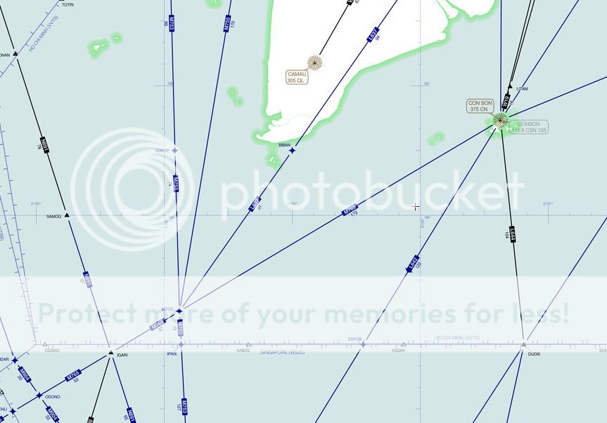
Link to Chart
I can visualise how an emergency developed approaching BITOD and they stopped navigating to troubleshoot an electrical problem, simply kept flying the same course, then a fire emerged and one pilot got up to use the fire extinguisher whilst probably Captain Zaharie Amad Shah selected a new heading on the autopilot to turn them south, then the fire got out of control, ruptured the fuselage and the rest was history.
The truth will emerge when they raise the black boxes. When they do i would bet money the last heading was from Vietnam, not from the Straits of Malacca.
edit on 19-4-2014 by sy.gunson because: (no reason given)
originally posted by: earthling42
a reply to: sy.gunson
Yes, the route from VAMPI to GIVAL and then heading to IGREX is false information.
Do you mean that an aircraft has to be logged on to an ATC for the transponder to transmit its position and thus is visible on civilian radar?
Short answer yes, at least above 28,000ft in that area.
I would say that the route was from Butterworth/Penang in the direction of VAMPI and passing by MEKAR to SANOB and IGEBO.
The route shown in the picture means it was not flying in an air corridor, i wonder if this is common practise to do so while heading to a waypoint.
This is a path towards the location where the signals were picked up.
It's speed must have been reduced to about 330kn after it had headed to a southerly direction, while the first part (take off and reaching the first ping line) must have been with a speed of at least 466kn.
The conflicting part is, it seems inconsistent with the data from Inmarsat which indicates that it was moving away from the satellite until 18:29.

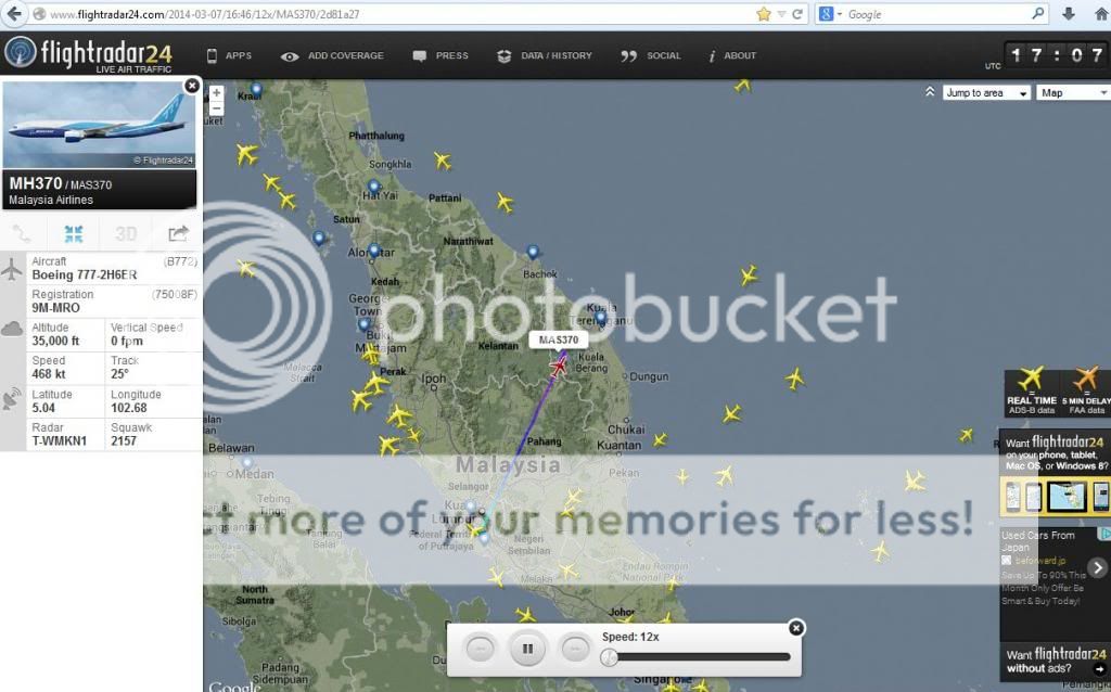
It was flying at 473kt at 35,000ft near IGARI.
Flying away from INMARSAT is consistent with the route it was expected to fly but inconsistent with what Malaysia claims.
After 25 minutes it seems to be heading towards the satellite for a few minutes which would indicate that there was a plan to divert from it's route and to head back to KL, it could have flown from IKUKO to VENLI and then made the decision to proceed on it's way to IGARI.
This would also be in line with MH370 contacting ATC at 17:07 for a confirmation about their altitude which to me seems strange to do because it already reported it's flightlevel at 17:01.
Every nation in the area controls a chunk of airspace called a Flight Information Region (FIR) by ICAO treaty. With recent technology in the last decade it has become possible to extend Air Traffic Service (ATS) over large oceanic areas using technology known as Future Air Navigation System (FANS 1/A).
FANS 1/A however requires a bunch of other technologies and if an aircraft doesn't have these, they are not permitted to fly above 28,000ft in FANS 1/A airspace. That technology began with oceanic flights between New Zealand and Australia in the 1990s, then it was adopted as a method of Air Traffic Control over continental Europe. After trials since 2008 Malaysian airspace was certified for this service in November 2013.
It requires aircraft with very precise autopilots, equipped with an advanced type of Automated Distributed Signal-Broadcast (ADS-B), Mode-S transponders and TCAS V.7. In fact these aircraft use what is known as ADS-C, which send updates of aircraft position altitude and speed every minute or so.
ADS-C operates a continuous data link with the relevant ATS and is contracted to the ATS controlling the airspace which an aircraft is using. The transponder sends data either via VHF ground link on 1,090 MHz, or via satellite, but in the case of MH370, only via VHF radio. Therefore there had to be a line of sight to a radio relay station.
When an aircraft passes from one FIR to another, then upon crossing the boundary the pilots have to key in the four letter log on code for that country.
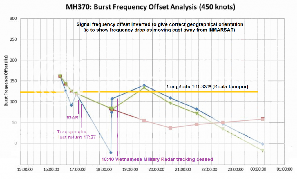
When you refer to MH370 flying toward the INMARSAT satellite you are actually discussing why the handshake Burst was offset by an increase in frequency.

Each hour, the satellite initiates interrogation of a cell on the surface of the earth with a narrow radio beam. The displacement of an aircraft within each cell creates an offset according to the delay, or compression of a signal return from inside that cell.
With MH370 the signal return offset is confusing because the frequency increased at 17:07 UTC rather than decreased. Decreased frequency should = flying east.
Possibly I don't understand the physics, but to me it appears as if the data is inverted. I have been told I don't understand it properly, but then I have never had it explained to me why I am wrong in a way that makes any sense.
MH370 turned east
This happens only when the signal is compressed. At 17:07 UTC we know from Radar surveilance exactly where MH370 was... It was flying east away from INMARSAT.
edit on 19-4-2014 by sy.gunson because: (no reason given)
a reply to: sy.gunson
Yes, of course..
A better startingpoint would be PIBOS, and then continue from there.
The data is above my head to, but so many are struggling with the Inmarsat data.
At first it is consistent, take off and moving away from the satellite, but then it is heading towards the satellite for a short time between 01:01 and 01:07 or 01:07 and 01:19 and then moving away from it again until 02:29 Malaysian time.
That would be consistent with flying towards and flying over Vietnam before it heads back towards Malaysia and maintain a southerly direction.
That is why i plotted a similary route which is comparable with your version
I do not know from which satellite the picture is which you posted, it seems to be EMEA.
The one which was tracking MH370 is 3F1 IOR 64.5° E.
Edit: i just found this inverted graph.
Yes, of course..
A better startingpoint would be PIBOS, and then continue from there.
The data is above my head to, but so many are struggling with the Inmarsat data.
At first it is consistent, take off and moving away from the satellite, but then it is heading towards the satellite for a short time between 01:01 and 01:07 or 01:07 and 01:19 and then moving away from it again until 02:29 Malaysian time.
That would be consistent with flying towards and flying over Vietnam before it heads back towards Malaysia and maintain a southerly direction.
That is why i plotted a similary route which is comparable with your version
I do not know from which satellite the picture is which you posted, it seems to be EMEA.
The one which was tracking MH370 is 3F1 IOR 64.5° E.
edit on 19-4-2014 by earthling42 because: (no reason given)
Edit: i just found this inverted graph.
edit on 19-4-2014 by
earthling42 because: (no reason given)
I tried to research this and what I found is that it's probably not a problem with your understanding of physics, but with your understanding of geography and the geographic location of the satellite.
originally posted by: sy.gunson
Possibly I don't understand the physics, but to me it appears as if the data is inverted. I have been told I don't understand it properly, but then I have never had it explained to me why I am wrong in a way that makes any sense.
The region we are talking about is near the equator.
One of the characteristics of the Inmarsat satellite is that its orbit takes it back and forth above and below the equator.
So I think what is absent in your analysis may be the possibility that while the plane is flying north, the satellite could be moving south and this can cause a Doppler shift up. You're jumping to unwarranted conclusions if you assume the data is inverted because you don't have enough information about the satellite's exact position and relative movement at each point in time (I don't have that information either, but inmarsat does). I don't know if the information is available on the internet, it might be, but I haven't really searched for it.
I have to see it I kept the link about the north movement. Here is a comment about it that is a bit different.
Besides MH370 moving "away " from the satellite , the satellite , being inclined was , for the first three hours , moving away from MH370, then for the final hours moving back "towards" the aircraft.
At the time the flight took off the sat was 1 deg 11 mins N of the equator
.Three hours later it was at the top of its " wobble " one deg 40 minutes north....and
by 2240 GMT it was back around one deg 11 minutes....having travelled around
the top of the figure of eight.inclination in orbit.
Here is the comment from a physics site person.
edit on 4/19/2014 by roadgravel because: (no reason given)
a reply to: roadgravel
Good find. As that says, it's a complex 3 dimensional problem and without precise data I think an oversimplified interpretation can be wrong.
Good find. As that says, it's a complex 3 dimensional problem and without precise data I think an oversimplified interpretation can be wrong.
a reply to: Arbitrageur
Also why didn't they show 7 arcs and where they intersected, etc. Was the single one some kind of composite. Each hour should generate it's own arc, right? I suppose as long as the pings continued the last is more likely the arc of the final area.
Also why didn't they show 7 arcs and where they intersected, etc. Was the single one some kind of composite. Each hour should generate it's own arc, right? I suppose as long as the pings continued the last is more likely the arc of the final area.
edit on 4/19/2014 by roadgravel because:
typo
Just as your cell phone links to the station, which is dynamic and this data is not stored anywhere to bring up in the future.
The same is true for Inmarsat mobile stations. So in actuality there is no data to look at of the past links
either to calculate the Doppler shift and what have you.
So the merry go around searches are actually perpetual motions.
The same is true for Inmarsat mobile stations. So in actuality there is no data to look at of the past links
either to calculate the Doppler shift and what have you.
So the merry go around searches are actually perpetual motions.
a reply to: roadgravel
That is also a strange occurrence, there were pings but not every hour.
It has been said that if the aircraft does not answer, every hour a handshake is done to see if it is still online.
The pings however were not hourly, let's start with 02:29, the next ping was at 03:40 with the following 3 pings as expected at 04:40, 05:40 and 06:40, but then we have to wait until 08:11 for the last ping and a partly ping at 8:19.
Because they aren't telling us everything, but I did some digging and found that they did in fact calculate more arcs than they shared with us:
originally posted by: roadgravel
a reply to: Arbitrageur
Also why didn't they show 7 arcs and where they intersected, etc. Was the single one some kind of composite. Each hour should generate it's own arc, right? I suppose as long as the pings continued the last is more likely the arc of the final area.
tmfassociates.com...
That is based on the ping delay, and I see analyses looking at the ping delay OR the doppler, but you really have to consider both. The article you linked to was talking mostly about Doppler, but that's only part of the story.
What was not stated initially by Inmarsat or the investigators was that each of the hourly arcs is further away from the satellite than the previous one. In other words the plane was moving away from the satellite continuously from sometime soon after the 2.11am ping. This statement was made by Inmarsat on Friday (and I have also confirmed it).
I'd like to see a good data set and analysis for the ping times AND the doppler data but I've only seen the doppler data.
originally posted by: earthling42
a reply to: sy.gunson
Yes, of course..
A better startingpoint would be PIBOS, and then continue from there.
PIBOS is East of Kuala Lumpur used by inbound/outbound aircraft as a waypoint in relation to standard instrument procedures. The Standard Instrument Departure (SID) for PIBOS was cancelled at take-off and MH370 was cleared direct to IGARI if I recall the transcript correctly, although they had to report in their climb passing 18,000ft and again passing 27,000ft
PIBOS
The data is above my head to, but so many are struggling with the Inmarsat data.
At first it is consistent, take off and moving away from the satellite, but then it is heading towards the satellite for a short time between 01:01 and 01:07 or 01:07 and 01:19 and then moving away from it again until 02:29 Malaysian time.
That would be consistent with flying towards and flying over Vietnam before it heads back towards Malaysia and maintain a southerly direction.
That is why i plotted a similary route which is comparable with your version
I do not know from which satellite the picture is which you posted, it seems to be EMEA.
The one which was tracking MH370 is 3F1 IOR 64.5° E.
Yes the problem is that a handshake at 18:07 was missing and that is most likely explained by MH370 flying east in which case the Pacific INMARSAT would have detected the aircraft and probably if you could have access to the data you would find that handshake was with the Pacific satellite in the cell covering Ho Chi Minh city.
The string of handshakes around 18:25 -18:27 UTC are probably MH370 flying back into coverage by the Indian Ocean satellite.
I plotted the hanshakes from INMARSAT 3F1 IOR at 64.5E. You could if you wish take the position pegs and measure distances from 3F1 IOR at each station along my route and measure them back to the INMARSAT position to see how they correlate to the Burst Offset Frequency chart.
Edit: i just found this inverted graph.
I created that inverted graph. It is not accurate in vertical scale. It was a speculative, subjective effort to visualise the Burst Offset Frequency so that the trend at 17:07 UTC matched radar surveilance.
In other words it made no sense to me that frequency was plotted increasing up to 18:25 UTC when an aircraft flying away from INMARSAT should have decreased in frequency. Only by inverting the data did the trend make much sense.
That led to me asking the question why if we knew it was flying away at 17:07 UTC did the Burst Offset show the opposite trend?
MH370 @ 17:07 UTC
originally posted by: roadgravel
originally posted by: jkpruitt
They know exactly how much fuel was on-board the aircraft...
They just won't tell the world...
That was disclosed very early, 31,000 US Gallons
originally posted by: roadgravel
a reply to: Arbitrageur
IIRC, INMARSAT said the sat was moving north at the time.
INMARSAT interrogated specific cells in the northern arc and in the sourthern arc with a very narrow radio beam.
Because at the times of these radio burst interrogations MH370 replied with a handshake ping and nothing more the satellite could not discriminate whether the aircraft replied from the north or south.
Part of the problem is that the satellite identifies a target and then tracks movement from one cell to the adjacent but in this case it appears unclear where it commenced tracking it from. Only somewhere generally in the centre between both arcs generally east of Singapore.
originally posted by: earthling42
a reply to: roadgravel
That is also a strange occurrence, there were pings but not every hour.
It has been said that if the aircraft does not answer, every hour a handshake is done to see if it is still online.
The pings however were not hourly, let's start with 02:29, the next ping was at 03:40 with the following 3 pings as expected at 04:40, 05:40 and 06:40, but then we have to wait until 08:11 for the last ping and a partly ping at 8:19.
There is no accurate informed answer. I plotted hourly handshakes as would have been expected in succession from the one at 17:07 UTC but this also assumed it would stay in contact with the Indian Ocean satellite, therefore at 18:07, 19:07 etc.
My mistake, because all my focus was on the handshakes before 18:25 UTC I gave no thought to when the handshakes occurred after 18:27. As you correctly note these happened at the hour +40 min.
One potential explanation is that it flew east out of coverage from the Indian Ocean into coverage from the Pacific satellite, so the periodic handshakes began on a new cycle.
edit on 19-4-2014 by sy.gunson because: (no reason given)
originally posted by: Arbitrageur
I tried to research this and what I found is that it's probably not a problem with your understanding of physics, but with your understanding of geography and the geographic location of the satellite.
originally posted by: sy.gunson
Possibly I don't understand the physics, but to me it appears as if the data is inverted. I have been told I don't understand it properly, but then I have never had it explained to me why I am wrong in a way that makes any sense.
The region we are talking about is near the equator.
One of the characteristics of the Inmarsat satellite is that its orbit takes it back and forth above and below the equator.
So I think what is absent in your analysis may be the possibility that while the plane is flying north, the satellite could be moving south and this can cause a Doppler shift up. You're jumping to unwarranted conclusions if you assume the data is inverted because you don't have enough information about the satellite's exact position and relative movement at each point in time (I don't have that information either, but inmarsat does). I don't know if the information is available on the internet, it might be, but I haven't really searched for it.
Fair comment, INMARSAT travels in an ellipsoid oval above and below the equator, however geographically the track describes a figure eight if plotted against the earth's surface (so I have been told) traveling this small racetrack at 50km/hr.
Duncan Steel publishes an excellent blog about this, but because i have no head for orbital dynamics I have steered away from studying it.
new topics
-
Putin, Russia and the Great Architects of the Universe
ATS Skunk Works: 2 hours ago -
A Warning to America: 25 Ways the US is Being Destroyed
New World Order: 6 hours ago
top topics
-
President BIDEN's FBI Raided Donald Trump's Florida Home for OBAMA-NORTH KOREA Documents.
Political Conspiracies: 12 hours ago, 30 flags -
A Warning to America: 25 Ways the US is Being Destroyed
New World Order: 6 hours ago, 12 flags -
Las Vegas UFO Spotting Teen Traumatized by Demon Creature in Backyard
Aliens and UFOs: 17 hours ago, 7 flags -
Is AI Better Than the Hollywood Elite?
Movies: 14 hours ago, 4 flags -
Maestro Benedetto
Literature: 14 hours ago, 1 flags -
Putin, Russia and the Great Architects of the Universe
ATS Skunk Works: 2 hours ago, 1 flags
active topics
-
University of Texas Instantly Shuts Down Anti Israel Protests
Education and Media • 273 • : HerbertWest -
Gaza Terrorists Attack US Humanitarian Pier During Construction
Middle East Issues • 42 • : 19Bones79 -
Krystalnacht on today's most elite Universities?
Social Issues and Civil Unrest • 6 • : FlyersFan -
Hate makes for strange bedfellows
US Political Madness • 50 • : 19Bones79 -
Weinstein's conviction overturned
Mainstream News • 28 • : burritocat -
Sunak spinning the sickness figures
Other Current Events • 25 • : Ohanka -
Cats Used as Live Bait to Train Ferocious Pitbulls in Illegal NYC Dogfighting
Social Issues and Civil Unrest • 24 • : NoviceStoic4 -
A Warning to America: 25 Ways the US is Being Destroyed
New World Order • 13 • : 2025yuga -
Is AI Better Than the Hollywood Elite?
Movies • 19 • : GENERAL EYES -
ChatGPT Beatles songs about covid and masks
Science & Technology • 24 • : iaylyan