It looks like you're using an Ad Blocker.
Please white-list or disable AboveTopSecret.com in your ad-blocking tool.
Thank you.
Some features of ATS will be disabled while you continue to use an ad-blocker.

What's going on at Yellowstone part 2
page: 4share:
reply to post by Olivine
Gotcha, they don't give an indication of what Yellow is on the legend then? Or is it just a color mismatch and it's actually in warning because of skewed data?
ETA: Just read the rest of your post. My bad, yep it's highlighted duh....
Gotcha, they don't give an indication of what Yellow is on the legend then? Or is it just a color mismatch and it's actually in warning because of skewed data?
ETA: Just read the rest of your post. My bad, yep it's highlighted duh....
edit on 30-3-2014 by sageturkey because: (no reason given)
sageturkey
reply to post by Olivine
Gotcha, they don't give an indication of what Yellow is on the legend then? Or is it just a color mismatch and it's actually in warning because of skewed data?
Correct. Yellow isn't on the legend. But if you click on a different station on the map, and then click the link to open said station--you will see that now it is highlighted yellow, and NRWY turns green. NRWY has good data.
It would take one of the geodesists to look at data and issue some sort of warning.
reply to post by Olivine
Many thanks for that link and alleviating concerns. So what does this new yellow dot mean (METAR). Looks like a Chinese throwing disc and is gold over red.
pbo.unavco.org...
Edit - never mind. It appears METAR is a weather reporting devise. Will file that into memory. Thanks again.
Many thanks for that link and alleviating concerns. So what does this new yellow dot mean (METAR). Looks like a Chinese throwing disc and is gold over red.
pbo.unavco.org...
Edit - never mind. It appears METAR is a weather reporting devise. Will file that into memory. Thanks again.
edit on 30-3-2014 by Dianec
because: (no reason given)
Dianec
reply to post by Olivine
Many thanks for that link and alleviating concerns. So what does this new yellow dot mean (METAR). Looks like a Chinese throwing disc and is gold over red.
pbo.unavco.org...
Edit - never mind. It appears METAR is a weather reporting devise. Will file that into memory. Thanks again.edit on 30-3-2014 by Dianec because: (no reason given)
METAR relates to weather forecasting. I've heard of it lurking on amateur meteorology sites, but don't know too much about it beyond that.
reply to post by Nyiah
Yea I should have just googled it. Need more coffee.
It seems quiet now so the 14 or so quakes for today will be added to the database to further understanding of this unique system, and we will remain perplexed as to what it is communicating to us. At least we have people studying it - a very positive thing.
Olivine
Correct. Yellow isn't on the legend. But if you click on a different station on the map, and then click the link to open said station--you will see that now it is highlighted yellow, and NRWY turns green. NRWY has good data.
I see, but the fact remains that the data it is showing is rapid uplift in the very area that had the earthquake, correct?
My impression is that most of these swarms they've had in the past decades have been related to changes in the elevation, either upward or downward. For example, the New Years' swarm several years ago coincided with a shift in the upward movement of the park to subsidence.
So the most likely explanation of all this is that these earthquakes are the result of the ground letting off energy in the Norris area caused by the uplift there recently. Doesn't mean anything is about to blow, and the rate of uplift still doesn't look *that* dramatically different from certain other prior periods of rapid uplift. But that's the most likely reason IMO.
Today's event is the largest earthquake at Yellowstone since February 22, 1980, and occurred near the center of a region of recent ground uplift described in a YVO Information Statement on February 18, 2014. The Yellowstone Volcano Observatory has been tracking this uplift episode for about 7 months. As discussed in the March 3, 2014 YVO Monthly Update, seismicity in the general region of the uplift has been elevated for several months. A previous period of uplift in this area occurred between 1996 and 2003, and it was also accompanied by elevated seismicity. A USGS field team is in Yellowstone and will visit the area near the earthquake's epicenter today. The team will look for any surface changes that the earthquake may have caused, and for possible effects to the hydrothermal system at Norris Geyser Basin. Based on the style and location of today's earthquake, at this time YVO sees no indication of additional geologic activity other than continuing seismicity.
Source
reply to post by sageturkey
That's the most worrisome official USGS report I recall ever reading about Yellowstone.
That's the most worrisome official USGS report I recall ever reading about Yellowstone.
reply to post by sageturkey
Awesome coinkydink.. Mt St .Helens blew its top in 1980..
Landslides, California upticks for quakes, now Yellowstone..
LETs Get it ON !!
Awesome coinkydink.. Mt St .Helens blew its top in 1980..
Landslides, California upticks for quakes, now Yellowstone..
LETs Get it ON !!
reply to post by Dianec
DianeC, FYI
SOURCE
DianeC, FYI
METAR is a format for reporting weather information. A METAR weather report is predominantly used by pilots in fulfillment of a part of a pre-flight weather briefing, and by meteorologists, who use aggregated METAR information to assist in weather forecasting.
SOURCE
edit on Sun, 30 Mar 2014 22:59:10
-050020142014-03-30T22:59:10-05:00kfSunday59America/ChicagoSun, 30 Mar 2014 22:59:10 -0500 by rockflier because: (no reason
given)
edit on Sun, 30 Mar 2014 23:01:16 -050020142014-03-30T23:01:16-05:00kfSunday01America/ChicagoSun, 30 Mar 2014 23:01:16 -0500 by
rockflier because: (no reason given)
reply to post by rockflier
Thank you - I figured that out after I googled it . In the future I'll google first - I think I was just a bit anxious at that time.
It's gone back to sleep as all is completely quiet on the seismographs now. Just another quake to say look at me (and we did).
Thank you - I figured that out after I googled it . In the future I'll google first - I think I was just a bit anxious at that time.
It's gone back to sleep as all is completely quiet on the seismographs now. Just another quake to say look at me (and we did).
reply to post by Dianec
I saw a documentary on some lady who keeps track of the level of the crater. Wonder if it has changed any..
---
Found some info on historic data:
pubs.usgs.gov...
news.nationalgeographic.com...
I saw a documentary on some lady who keeps track of the level of the crater. Wonder if it has changed any..
---
Found some info on historic data:
pubs.usgs.gov...
edit on 31-3-2014 by nOraKat because: (no reason given)
news.nationalgeographic.com...
edit on 31-3-2014 by nOraKat
because: (no reason given)
reply to post by nOraKat
how deep was the caldera 600.000 years ago.... how much has it risen up ever since...?????
how deep was the caldera 600.000 years ago.... how much has it risen up ever since...?????
The fact that this same uplift happened around 2003 is comforting from the report on the 4.7 (was downgraded), but the fact that this was a stronger
quake is not. I would like to see a comparison of the swarm accompanying the uplift between 1996-2003. Maybe the first 7 months of that one to this
one. If anyone has done that what does it look like?
If I can find that archived data I can mess around with it and see if there were more or less quakes and their mags but for someone who can't interpret all of the particulars it would be a crude attempt.
If I can find that archived data I can mess around with it and see if there were more or less quakes and their mags but for someone who can't interpret all of the particulars it would be a crude attempt.
reply to post by Dianec
She's picking back up again... LINK
Interesting to see what (if anything) happens with this. A new swarm or just a re-settling after the quake?
She's picking back up again... LINK
Interesting to see what (if anything) happens with this. A new swarm or just a re-settling after the quake?
reply to post by westcoast
Yea - if that area starts to balloon really fast I'll just plan my vacation (good excuse).
How big of an area are we talking about? In miles or square feet (km/meters)? I know YS from being there and the maps but I've only connected a few spots together in my mind (map/actual location). If only a few square meters of uplift this wouldn't be as worrisome as a few hundred square meters.
I don't know why but I've always imagined this a small bulge happening when they speak of uplift. Probably because of the map - difficult to gauge by looking at it (for me).
reply to post by Dianec
I honestly can't remember what the size of the area of uplift is.
I'm planning on going there this summer for a week of camping/hiking/photos for a guide book I want to make, so I hope this doesn't turn into long ordeal. However...that might make the trip even more exciting!
I honestly can't remember what the size of the area of uplift is.
I'm planning on going there this summer for a week of camping/hiking/photos for a guide book I want to make, so I hope this doesn't turn into long ordeal. However...that might make the trip even more exciting!
I still are a bit worried with regards to the Helium discovery at Yellowstone.
What I know is that when Helium -4 was seen at other volcanoes, it then appeared shortly before major eruptions of those volcanoes.
Why are suddenly Yellowstone different?
It would be nice to know how much of the helium came straight from the mantle, and how much came from fresh breaks and fractures in the crust below.
I should maybe not listen to rumors but it is said that since late summer 2013, the Yellowstone GPS network has tracked a small ” ground deformation episode” in north-central Yellowstone National Park, and that during the past five months, the NRWY GPS station has recorded about 3.5 cm uplift and about 1 cm of southeastward ground movement, relative to a stable reference station north of the Park.
Measurements from other GPS stations in northern Yellowstone are said to show smaller displacements, forming a circular pattern of deformation consistent with a minor pressurization, about 6 to 10 km deep, near Norris Junction.
Can anyone confirm this uplift?
reply to post by Roald
Hi Roald. Yes, there is currently uplift near Norris Junction. It is not a rumor.
This is found on the YVO main page:
And this is from the Feb. 18, 2014 link:
If you would like to see the current deformation at the Norris GPS station, here is the link to the cleaned & detrended data.
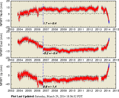
Data from additional surrounding stations can be found here.
As far as the helium, YVO says:
(also found on their main page--link above)
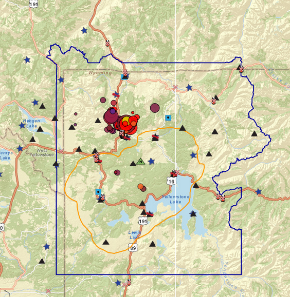
Finally, the YVO has updated their Monitoring page to show more of the smaller quakes in this swarm. Several of them were only 1.8 to 2.0 kms deep.
Hi Roald. Yes, there is currently uplift near Norris Junction. It is not a rumor.
This is found on the YVO main page:
Is the recent episode of ground deformation worrisome?
No. Current rates of ground deformation are well within historical norms. Please see our February 18, 2014 Information Statement, for more information about ground deformation at Yellowstone
And this is from the Feb. 18, 2014 link:
Since late summer 2013, the Yellowstone GPS network has tracked a small ground deformation episode in north-central Yellowstone National Park. During the past five months, the NRWY GPS station has recorded about 3.5 cm (1.4 in) of uplift and about 1 cm (0.4 in) of southeastward ground movement, relative to a stable reference station north of the Park. Measurements from other GPS stations in northern Yellowstone show smaller displacements, forming a circular pattern of deformation consistent with a minor pressurization, about 6 to 10 km (4-6 miles) deep, near Norris Junction.
Similar patterns of ground deformation have occurred before in this part of Yellowstone. From 1996 through 2003 the Norris Geyser Basin rose about 12 cm, before beginning to subside in 2004. More information about this event is available at volcanoes.usgs.gov...
If you would like to see the current deformation at the Norris GPS station, here is the link to the cleaned & detrended data.
Data from additional surrounding stations can be found here.
As far as the helium, YVO says:
Do helium emissions at Yellowstone signal an impending eruption?
No. YVO Scientist-in-Charge Jacob Lowenstern and colleagues recently published research on helium (He) emissions at Yellowstone in the journal Nature. The new research looked at apparent changes in the helium output of the Yellowstone area during its two-million-year volcanic history, compared with the previous two billion years of comparative stability. The research has nothing to do with current activity at Yellowstone, and has no implications about volcanic hazards. For a humorous and informative take on the new research, watch this video, or read this news article.
(also found on their main page--link above)
Finally, the YVO has updated their Monitoring page to show more of the smaller quakes in this swarm. Several of them were only 1.8 to 2.0 kms deep.
edit on 4/1/2014 by Olivine because: add a pic
new topics
-
Top Sci Fi/Horror Crossover Movies
Movies: 2 hours ago -
Magic Vaporizing Ray Gun Claim - More Proof You Can't Believe Anything Hamas Says
War On Terrorism: 3 hours ago -
One out of every 20 Canadians Dies by Euthanasia
Medical Issues & Conspiracies: 3 hours ago -
USS Liberty - I had no idea. Candace Owen Interview
US Political Madness: 4 hours ago
top topics
-
USS Liberty - I had no idea. Candace Owen Interview
US Political Madness: 4 hours ago, 12 flags -
Magic Vaporizing Ray Gun Claim - More Proof You Can't Believe Anything Hamas Says
War On Terrorism: 3 hours ago, 6 flags -
Top Sci Fi/Horror Crossover Movies
Movies: 2 hours ago, 5 flags -
What Am I Hearing
General Chit Chat: 12 hours ago, 4 flags -
One out of every 20 Canadians Dies by Euthanasia
Medical Issues & Conspiracies: 3 hours ago, 4 flags
active topics
-
Angela Merkel is terrified of dogs
Politicians & People • 5 • : 777Vader -
Magic Vaporizing Ray Gun Claim - More Proof You Can't Believe Anything Hamas Says
War On Terrorism • 5 • : Oldcarpy2 -
FBI Director CHRISTOPHER WRAY Will Resign Before President Trump Takes Office on 1.20.2025.
US Political Madness • 19 • : ADVISOR -
-@TH3WH17ERABB17- -Q- ---TIME TO SHOW THE WORLD--- -Part- --44--
Dissecting Disinformation • 3639 • : duncanagain -
One out of every 20 Canadians Dies by Euthanasia
Medical Issues & Conspiracies • 8 • : network dude -
Will all hell break out? Jersey drones - blue beam
Aliens and UFOs • 46 • : grey580 -
USS Liberty - I had no idea. Candace Owen Interview
US Political Madness • 10 • : AgarthaSeed -
Remember These Attacks When President Trump 2.0 Retribution-Justice Commences.
2024 Elections • 105 • : Oldcarpy2 -
Should be BANNED!
General Chit Chat • 17 • : TheSemiskepticII -
Instrumental Surf Music - Origins to the Present Day
Music • 248 • : underpass61