It looks like you're using an Ad Blocker.
Please white-list or disable AboveTopSecret.com in your ad-blocking tool.
Thank you.
Some features of ATS will be disabled while you continue to use an ad-blocker.

world weather / wind map
page: 1share:
earth.nullschool.net.../wind/surface/level/orthographic=-38.29,58.78,408
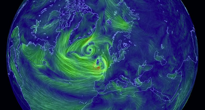
I found this very interesting, and it really illustrates what is going on re the current UK storms
I found this very interesting, and it really illustrates what is going on re the current UK storms
What the heck is going on in the North Atlantic? Looks like TPTB are messing with the Icelanders because of what they did to the banisters :O
edit on 12-2-2014 by Bilk22 because: (no reason given)
Wind is strong, I dont moan about the weather anymore London gets the least of it. I feel sorry for the rest of the UK.
The engine that drives our weather has developed a distinct ping and knock over time. Unfortunately, Earth has no mechanics with the knowledge or
skill right now to do much more than make it worse, IMO.
Wrabbit2000
The engine that drives our weather has developed a distinct ping and knock over time. Unfortunately, Earth has no mechanics with the knowledge or skill right now to do much more than make it worse, IMO.
I hope the old girl dont start dieseling
I'm sorry if the link is not working for anyone. It should open as a real time animation of storm and wind patterns around the world. Funnily, the
link doesn't work for me on this site either
reply to post by Bilk22
From what i could tell, the perturbations of the jet stream in the North American region is causing a significant spike that is basically sling shotting these storms across the Atlantic and into the UK. It's actually running in a distinct stream from the SE corner of the US and right up to the UK. Not sure if it's still doing it but that's what it looked like a few days ago.
From what i could tell, the perturbations of the jet stream in the North American region is causing a significant spike that is basically sling shotting these storms across the Atlantic and into the UK. It's actually running in a distinct stream from the SE corner of the US and right up to the UK. Not sure if it's still doing it but that's what it looked like a few days ago.
Here you go...
earth.nullschool.net...
That works....love the way you can twiddle the earth around!
Rainbows
Jane
earth.nullschool.net...
That works....love the way you can twiddle the earth around!
Rainbows
Jane
edit on 12-2-2014 by angelchemuel because: (no reason given)
Looks like a major vortex just below Iceland is pulling the cold air down off the Arctic and causing a lot of weather. Is that natural?
WhiteAlice
reply to post by Bilk22
From what i could tell, the perturbations of the jet stream in the North American region is causing a significant spike that is basically sling shotting these storms across the Atlantic and into the UK. It's actually running in a distinct stream from the SE corner of the US and right up to the UK. Not sure if it's still doing it but that's what it looked like a few days ago.
Bilk22
Looks like a major vortex just below Iceland is pulling the cold air down off the Arctic and causing a lot of weather. Is that natural?
WhiteAlice
reply to post by Bilk22
From what i could tell, the perturbations of the jet stream in the North American region is causing a significant spike that is basically sling shotting these storms across the Atlantic and into the UK. It's actually running in a distinct stream from the SE corner of the US and right up to the UK. Not sure if it's still doing it but that's what it looked like a few days ago.
Its normal, this year. The wind is going around the lower pressure center. Those low pressures have caused flooding in Great Britain. I have never seen so many deep lower pressures developing in the Atlantic.
If you want to see Jet Streams, choose Height 250 hPa. Those winds are very fast and show how jet streams work.
edit on 12-2-2014 by Thebel
because: (no reason given)
Bilk22
Looks like a major vortex just below Iceland is pulling the cold air down off the Arctic and causing a lot of weather. Is that natural?
WhiteAlice
reply to post by Bilk22
From what i could tell, the perturbations of the jet stream in the North American region is causing a significant spike that is basically sling shotting these storms across the Atlantic and into the UK. It's actually running in a distinct stream from the SE corner of the US and right up to the UK. Not sure if it's still doing it but that's what it looked like a few days ago.
In a nutshell: No.. All of our peculiar weather patterns seem to be related to the behavior of the polar vortex. It has weakened and expanded so it's not sitting like a nice and tidy cap on the head of the earth like it usually is. I do know that some of the important oceanic currents that help regulate our typical weather are floundering a bit as well. The Labrador Current (northern originating) in the Atlantic Ocean has weakened due to warming (likewise, the Oyashio Current in the Pacific Ocean is weakening as well). The overall effect of all of these things for the Atlantic is the perturbation of the North Atlantic Oscillation--basically, the weather stream in the Atlantic. It's utterly SNAFU and to be quite honest, what is happening scares the devil out of me if it turns out to be relatively permanent.
Whether it's completely natural or not, I do not know. There's all sorts of things involved with weather/climate generation on the planet; ergo, I don't think it's just one thing but most of it seems to relate to a weakened polar vortex and warming oceans. Also interesting is that a glance at the glacial vegetation maps from the previous ice age seems to hint at a similar type of weather pattern that we're seeing now in the US with a drier steppe/arid climate on the West Coast (currently in drought) and colder taiga environments East of the Rockies (currently experiencing deep dips of the polar vortex). Pretty coincidental.
www.redorbit.com...
www.noaa.gov...
Thebel
Bilk22
Looks like a major vortex just below Iceland is pulling the cold air down off the Arctic and causing a lot of weather. Is that natural?
WhiteAlice
reply to post by Bilk22
From what i could tell, the perturbations of the jet stream in the North American region is causing a significant spike that is basically sling shotting these storms across the Atlantic and into the UK. It's actually running in a distinct stream from the SE corner of the US and right up to the UK. Not sure if it's still doing it but that's what it looked like a few days ago.
Its normal, this year. The wind is going around the lower pressure center. Those low pressures have caused flooding in Great Britain. I have never seen so many deep lower pressures developing in the Atlantic.
If you want to see Jet Streams, choose Height 250 hPa. Those winds are very fast and show how jet streams work.edit on 12-2-2014 by Thebel because: (no reason given)
It's only normal for the last couple years. In that way alone, it could be our "new normal". What's interesting is what is occurring in the Pacific is a significant high pressure ridge (comically dubbed the Ridiculously Resistant Ridge), which is bumping the typical precipitation that hits the West coast northward. So high pressures on the Pacific side of things. www.mercurynews.com...
Care to explain that in layman's terms?
WhiteAlice
Bilk22
Looks like a major vortex just below Iceland is pulling the cold air down off the Arctic and causing a lot of weather. Is that natural?
WhiteAlice
reply to post by Bilk22
From what i could tell, the perturbations of the jet stream in the North American region is causing a significant spike that is basically sling shotting these storms across the Atlantic and into the UK. It's actually running in a distinct stream from the SE corner of the US and right up to the UK. Not sure if it's still doing it but that's what it looked like a few days ago.
In a nutshell: No.. All of our peculiar weather patterns seem to be related to the behavior of the polar vortex. It has weakened and expanded so it's not sitting like a nice and tidy cap on the head of the earth like it usually is. I do know that some of the important oceanic currents that help regulate our typical weather are floundering a bit as well. The Labrador Current (northern originating) in the Atlantic Ocean has weakened due to warming (likewise, the Oyashio Current in the Pacific Ocean is weakening as well). The overall effect of all of these things for the Atlantic is the perturbation of the North Atlantic Oscillation--basically, the weather stream in the Atlantic. It's utterly SNAFU and to be quite honest, what is happening scares the devil out of me if it turns out to be relatively permanent.
Whether it's completely natural or not, I do not know. There's all sorts of things involved with weather/climate generation on the planet; ergo, I don't think it's just one thing but most of it seems to relate to a weakened polar vortex and warming oceans. Also interesting is that a glance at the glacial vegetation maps from the previous ice age seems to hint at a similar type of weather pattern that we're seeing now in the US with a drier steppe/arid climate on the West Coast (currently in drought) and colder taiga environments East of the Rockies (currently experiencing deep dips of the polar vortex). Pretty coincidental.
www.redorbit.com...
www.noaa.gov...
reply to post by Bilk22
Basic rule is that warm air expands and cold air contracts. Right now, the polar vortex looks "bigger" and that's likely due to it being warmer. However, if it's getting warmer, then, logically, the air south of it is even warmer. The world's oceans are like a gigantic heat sink so what develops there is going to slap and push around the weaker vortex like it's nothing. Hence the big dips of the polar vortex into more unlikely locations in North America (ie Atlanta, Georgia).
Think of it as a high intensity boxer basically slapping around a wimpy fat kid. The oceans are the boxer's turf and the boxer's turf is growing northward (warmer water pushing up further north--those weakened currents) and so the wimpy kid keeps ducking into the continents and then getting bullied northward again once it hits the ocean again.
This is a water vapor satellite radar image of that interaction. Give it a few to get the map underneath to load and then, watch what happens over the oceans and continents. You can really see that stream going strongly NE straight into the UK as well.
climate.cod.edu...
UK storms with temperatures which is great for seeing that cold/warm air slam: www.theguardian.com...
lol, I probably messed that up somewhere. Just think oceans = bully fronts and the polar vortex is the wimpy fat kid right now.
Yea there's a lot of water vapor coming out of the North Pole. Affecting all sides.
reply to post by Bilk22
re Iceland
also thats where the warm gulf stream cools and sinks in a huge toilet flush type action and goes into the return phase towards the south eventually
the old whirl pool of lost ships
re Iceland
also thats where the warm gulf stream cools and sinks in a huge toilet flush type action and goes into the return phase towards the south eventually
the old whirl pool of lost ships
edit on 12-2-2014 by Danbones because: (no reason given)
If this is a map of precipitation not only is England getting hit but it looks like a lot of activity globally. Maybe that's normal but something to
watch to see what is/is not normal. With regard to ships lost in this area - I can see that. Can't even imagine being out at sea in that.
new topics
-
US Air Force Secretary Kendall flies in cockpit of plane controlled by AI
Aircraft Projects: 3 hours ago -
Messages of Hope – Unity through AI
Dreams & Predictions: 4 hours ago -
Happy Cinco de mayo.
General Chit Chat: 4 hours ago -
The BEAST System of Revelation has been awoken and has assumed control, at least since COVID.
New World Order: 8 hours ago
top topics
-
The Department of Justice Spies on Congress with Google Assisting.
Political Conspiracies: 14 hours ago, 8 flags -
The BEAST System of Revelation has been awoken and has assumed control, at least since COVID.
New World Order: 8 hours ago, 6 flags -
Messages of Hope – Unity through AI
Dreams & Predictions: 4 hours ago, 1 flags -
US Air Force Secretary Kendall flies in cockpit of plane controlled by AI
Aircraft Projects: 3 hours ago, 1 flags -
Happy Cinco de mayo.
General Chit Chat: 4 hours ago, 0 flags
active topics
-
Modern Mind Control
General Conspiracies • 36 • : whereislogic -
Manly P. Hall says Freemasonry is a religion?
Secret Societies • 28 • : nothwbush -
Russia Ukraine Update Thread - part 3
World War Three • 5760 • : Imhere -
Happy Cinco de mayo.
General Chit Chat • 2 • : IceHappy -
Mood Music Part VI
Music • 3156 • : Hellmutt -
SC Jack Smith is Using Subterfuge Tricks with Donald Trumps Upcoming Documents Trial.
Dissecting Disinformation • 128 • : Vermilion -
Now is The Time to Tell Americans What Really Happened on 1.6.2021 at our U.S. Capitol.
Political Conspiracies • 198 • : WeMustCare -
Remember These Attacks When President Trump 2.0 Retribution-Justice Commences.
2024 Elections • 67 • : WeMustCare -
Really Unexplained
General Chit Chat • 120 • : andy06shake -
The adventure of publishing books
People • 11 • : DISRAELI2