It looks like you're using an Ad Blocker.
Please white-list or disable AboveTopSecret.com in your ad-blocking tool.
Thank you.
Some features of ATS will be disabled while you continue to use an ad-blocker.

Quake Watch 2012
page: 35share:
Originally posted by muzzy
reply to post by The Great Day
said on the TV News here in New Zealand that there had been 200 aftershocks (and that was 3.5 hrs ago).
only 27 shown on Philippine Institute of Volcanology and Seismology @ this point in timeedit on 7-2-2012 by muzzy because: (no reason given)
A very hard task but i thought i would ask as you seem to be clued up as to where to look. I would appreciate it if you could let me know of a site or link to an image that depicts the locations and orders so far of the quakes in the Philippine area. If you dont mind that is. Its sort of important. Thanks.
Originally posted by muzzy
maybe it was just update time, surely they didn't just have 400 odd more in 10 minutes
here be the 30 day the map
well it was
Thanks muzzy. And I think that's right. If the numbers on the home page signify totals for the day, and the preceding day, then they get thousands of tremors every day. but again, its in Japanese, and dont know for sure.
------------------------------------------------------------
reply to post by PuterMan
Thanks PuterMan
So far back 30 days looks to be it. But the data has got to be in their system some where, so Im going fishing.
reply to post by zworld
I sent a link to this post and the one wih the japanese site to it to a friend of mine who is majoring in Japanese and Chinese, will let you know when she replies.
Heck, maybe I can make her an ATS convert
Is there anyone who knows Japanese.
I sent a link to this post and the one wih the japanese site to it to a friend of mine who is majoring in Japanese and Chinese, will let you know when she replies.
Heck, maybe I can make her an ATS convert
reply to post by jazz10
here ya go map of those quakes on the list below after the 6.9
Threw it together quickly, its in descending magnitude, I didn't have time to reformat the times
*edit ~ reformatted into descending time order now, same link should have the new layout.
the list again
here ya go map of those quakes on the list below after the 6.9
*edit ~ reformatted into descending time order now, same link should have the new layout.
the list again
edit on 7-2-2012 by muzzy because: (no reason
given)
Originally posted by MoorfNZ
Magnitude 5.3, Tuesday, February 7 2012 at 11:21 pm (NZDT), 30 km west of Taumarunui, North Island, New Zealand
Depth 250km
Felt Map: www.geonet.org.nz...
Felt that here, a jolt then a mild shaking just for a couple of seconds, MM4
Magnitude mb 5.0
Region SVALBARD REGION
Date time 2012-02-07 23:37:03.0 UTC
Location 77.05 N ; 7.24 E
Depth 2 km
Distances 1210 km NW Murmansk (pop 319,263 ; local time 02:37:03.3 2012-02-08)
898 km NW Tromsø (pop 52,436 ; local time 00:37:03.3 2012-02-08)
201 km SW Barentsburg (pop 576 ; local time 00:37:03.3 2012-02-08)
EMSC
Aftershocks and all that.
Source; regd.pdf Title: Universality of the Seismic Moment-frequency Relation
Go to page 16 (bottom) of 37
So for a Mag 8+ 200km radius for 2 years can be considered aftershocks.
Source; regd.pdf Title: Universality of the Seismic Moment-frequency Relation
Go to page 16 (bottom) of 37
In particular, the epicentral distance limits (in km) are calculated according to the formula..........[formula does not print]...............
The aftershock zone sizes are 4.6 km for m 4 and 46 km for m 6.5. For the time limits we use the following formula, a variant..........[formula does not print]...............
Equation (6) yields a time limit of 3.33 days for m =4 and 33.3 days for m= 5.5. If an earthquake is in the time-distance window of another larger preceding event, it is deleted from the declustered catalog.
MOLCHAN et al. (1996, 1997, p. 1223) propose the following windows for removing aftershocks: for m 6.5 the time range is 2 years. The spatial window radius is 50, 60, 70, 100, and 200 km for the earthquake magnitude ranges 5.5–6.5, 6.5–7.0, 7.0–7.5, 7.5–8.0, and >=8.0, respectively.
We use the results of the likelihood analysis of earthquake catalogs (KAGAN, 1991c) as a third declustering method. We approximate an earthquake occurrence by a multidimensional Poisson cluster process, i.e., origin time, earthquake size, and centroid location are modelled. In this model mainshocks are distributed according
to the Poisson distribution, whereas dependent events in earthquake sequences are controlled by a distribution which is characterized by a few adjustable parameters.
So for a Mag 8+ 200km radius for 2 years can be considered aftershocks.
Was expecting this - the region has been too quiet of late
Mag 5.3 - Kermadecs
Depth 54.7km
Source: earthquake.usgs.gov...
Mag 5.3 - Kermadecs
Depth 54.7km
Source: earthquake.usgs.gov...
Originally posted by diamondsmith
The death tall from Filipino earthquake is rising,and very strange they had large waves that hit some towns.
source(blogs.voanews.com...
TextFilipino officials say a strong earthquake has rocked the central Philippines, killing at least 43 people and causing widespread damage and power outages.officials say there is no concern of a tsunami, although some coastal towns nearby were hit by large waves.
and going up...two villages buried
www.bworldonline.com...
edit on 7-2-2012 by The Great Day because: (no reason given)
7.1 2012/02/02 13:34:41 -17.766 167.134 23.1 VANUATU
6.0 2012/02/03 03:46:23 -17.376 167.278 21.7 VANUATU
6.1 2012/02/05 00:15:41 -18.935 168.923 163.4 VANUATU
6.0 2012/02/05 16:40:40 -17.952 167.230 10.3 VANUATU
6.7 2012/02/06 03:49:17 9.964 123.246 11.0 NEGROS - CEBU REGION, PHILIPPINES
6.0 2012/02/06 10:10:24 9.874 123.070 15.0 NEGROS - CEBU REGION, PHILIPPINES
big week - what's next?
Originally posted by berkeleygal
7.1 2012/02/02 13:34:41 -17.766 167.134 23.1 VANUATU
6.0 2012/02/03 03:46:23 -17.376 167.278 21.7 VANUATU
6.1 2012/02/05 00:15:41 -18.935 168.923 163.4 VANUATU
6.0 2012/02/05 16:40:40 -17.952 167.230 10.3 VANUATU
6.7 2012/02/06 03:49:17 9.964 123.246 11.0 NEGROS - CEBU REGION, PHILIPPINES
6.0 2012/02/06 10:10:24 9.874 123.070 15.0 NEGROS - CEBU REGION, PHILIPPINES
big week - what's next?
im not of the earthquake cult....
but dam the trend is undeniable for the casual observer
edit on 8-2-2012 by The Great Day because: (no reason given)
Originally posted by jadedANDcynical
reply to post by zworld
Is there anyone who knows Japanese.
I sent a link to this post and the one wih the japanese site to it to a friend of mine who is majoring in Japanese and Chinese, will let you know when she replies.
Heck, maybe I can make her an ATS convert
Thanks J&C. I never realized how different Japanese is from english. Trying to get data through google translations is really trying. If we could get a good translator aboard it would be a major coup.
Ive been through as much of the hinet site as I can figure out and it looks like you have to have a registered account to go back further than the 30 day window. Or theres someway to do it and its going to take someone knowing the dialect.
For the heck of it I downloaded the map for the last 30 days of EQs in Japan. Holy batpeople, I thought we had alot of EQs.
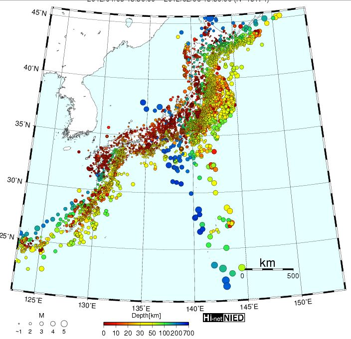
And to think there are 58 nuclear power plants under all those pretty colors.
edit on 8-2-2012 by zworld because: (no reason
given)
source(earthquake.usgs.gov...
TextMagnitude 5.6 Date-Time Wednesday, February 08, 2012 at 10:54:43 UTC Wednesday, February 08, 2012 at 05:54:43 AM at epicenter Time of Earthquake in other Time Zones Location 0.682°N, 79.187°W Depth 69.8 km (43.4 miles) Region NEAR THE COAST OF ECUADOR Distances 65 km (40 miles) ESE of Esmeraldas, Ecuador 102 km (63 miles) N of Santo Domingo de los Colorados, Ecuador 124 km (77 miles) WNW of Ibarra, Ecuador 125 km (77 miles) NW of QUITO, Ecuador Location Uncertainty horizontal +/- 16.8 km (10.4 miles); depth +/- 8.5 km (5.3 miles) Parameters NST=396, Nph=411, Dmin=95.7 km, Rmss=0.83 sec, Gp= 90°, M-type=body wave magnitude (Mb), Version=8
source(earthquake.usgs.gov...
TextMagnitude 5.6 Date-Time Wednesday, February 08, 2012 at 12:01:37 UTC Wednesday, February 08, 2012 at 09:01:37 PM at epicenter Time of Earthquake in other Time Zones Location 37.838°N, 138.099°E Depth 9.7 km (6.0 miles) Region NEAR THE WEST COAST OF HONSHU, JAPAN Distances 84 km (52 miles) W of Niigata, Honshu, Japan 132 km (82 miles) N of Nagano, Honshu, Japan 148 km (91 miles) NNE of Toyama, Honshu, Japan 280 km (173 miles) NNW of TOKYO, Japan Location Uncertainty horizontal +/- 14.2 km (8.8 miles); depth +/- 6.3 km (3.9 miles) Parameters NST=413, Nph=413, Dmin=143.6 km, Rmss=0.66 sec, Gp= 97°, M-type=regional moment magnitude (Mw), Version=7
Magnitude mb 5.0
Region OFFSHORE CHIAPAS, MEXICO
Date time 2012-02-08 13:06:47.0 UTC
Location 15.05 N ; 94.03 W
Depth 60 km
Distances 190 km W Tapachula (pop 197,961 ; local time 07:06:47.7 2012-02-08)
112 km SW Pijijiapan (pop 15,101 ; local time 07:06:47.7 2012-02-08)
106 km SW Tres picos (pop 4,881 ; local time 07:06:47.7 2012-02-08)
EMSC
reply to post by PuterMan
Hi Puterman,
fascinating post. Thank you; I for one spent a couple of hours mulling over everything you put into it and longer than that digging back through the various reports (mainly pdfs) I have accumulated that deal with the CSZ and especially the paleoseismological aspects of it.
One reason I went digging is because you state that “In 1600 there was a mag 9 quake.” My jaw hit the floor when I read that, because it's the first time I'd seen any reference to a mag 9 quake in the CSZ in 1600. In 1700, yes: that one is pretty well tied down to the exact day and hour (as I guess most here would know), but another mag 9 quake 100 years before it? I couldn't find any reference to one – but then, there is no way I have read all the research that's been done.
So, because the number of these huge (~ mag 9) quakes in that region is vital to the validity of your calculations as they stand, could you possibly give a reference for the 1600 event? I'd like to read up on it and find out what evidence they used to identify it and hence added it to the list of known major events there in the past several thousand years.
As for the one you mention in 1200, I'm still looking through my own references to find it. But I recall something about it, at least! (But I thought it was a partial rupture rather than a full rupture. Apologies, I'm probably addled.) ADD EDIT: Found it! Pratt & Weaver et al from way back in 2002 refer to it as between 900 and 1300 years ago and I'm sure I have a more recent doccy that narrows it down more. END EDIT
However it's the 1600 event that really bothers me because I don't know how I missed it!
Have to agree with your basic asssertion, though: even the experts in the business seem in accord that (geologically speaking) the CSZ is in the time window for another major event.
Mike
edit on 8/2/12 by JustMike because: Added edit
Many people are trying to connect earthquakes to the Sun. I do not disagree with this I just have yet to come up with the proper connection in my
opinion.
This page is NOT about earthquakes but is entitled: One possible explanation for the cyclicity in the Sun. (SEE LINK BELOW BEFORE COPYING ALL THAT OUT)
It is in 8 parts and frankly the web site is appalling and quite difficult to read. Despite that it is a fascinating read and goes back to cycles many hundreds of millions of years ago deduced from rock samples.
The paper is all about the various cycles of the Sun (and about the coming Grand Minimum) but in there I suspect is the confirmation of the Sun affecting earthquakes. The 55 year cycles seems to tie in to me but there are some periods where it does not match but this it seems may be explained by the other cycles that are overlaid on each other cancelling out.
I have created a PDF of the site (109 A4 pages in all) that much more readable and you can get a copy of it here.
reply to post by JustMike
Hi Mike,
The details below are not the actual site I got the information from but are similar. I remember the one I looked at had pictures and was a web site rther than a PDF.
Source
Unfortunately I cant find where I got the original full version but I can tell you that it is from AREPS. This is the full title and author.
Holocene Earthquake Records From the Cascadia Subduction Zone and Northern San Andreas Fault Based on Precise Dating of Offshore Turbidites
Chris Goldfinger, C Hans Nelson, Joel E Johnson in Annual Review of Earth and Planetary Sciences (2003)
That of course would indicate 300 years to the next one but....
Source: Fault slip and seismic moment of the 1700 Cascadia earthquake inferred from Japanese tsunami descriptions: JOURNAL OF GEOPHYSICAL RESEARCH, VOL. 108, NO. B11, 2535, doi:10.1029/2003JB002521, 2003
So the dates 1200, 1600, 1700 are there but now I am not sure. The other site put these turbidites that are visible at the southern end of the slip zone (northern San Andreas) as being the ~ages of major Cascadia events.
I must try and find the other site.
I remember it was very naff and amateur as are most site constructed by geologists and the like!!
Hi Mike,
The details below are not the actual site I got the information from but are similar. I remember the one I looked at had pictures and was a web site rther than a PDF.
New stratigraphic evidence from Cascadia demonstrates that 13 earthquakes ruptured the entire margin from Vancouver Island to at least
the California border since the eruption of the Mazama ash 7700 years ago. The 13 events above this prominent stratigraphic marker have an average repeat time of 600 years, and the youngest event » 300 years ago coincides with the coastal record.
Source
Unfortunately I cant find where I got the original full version but I can tell you that it is from AREPS. This is the full title and author.
Holocene Earthquake Records From the Cascadia Subduction Zone and Northern San Andreas Fault Based on Precise Dating of Offshore Turbidites
Chris Goldfinger, C Hans Nelson, Joel E Johnson in Annual Review of Earth and Planetary Sciences (2003)
That of course would indicate 300 years to the next one but....
The turbidite event stratigraphy shows a clear record for the northern » 600 km of the Cascadia Basin, the entire length of the subduction zone offshore from Washington and Oregon has ruptured 18 times in great earthquakes during the past » 9800
Around Mag 8.5 to 9
The Bradley Lake record is based only on tsunami deposited sands, exhibits a relatively greater number of events per unit time than the estuary records, and has 12 events requiring a tsunami inundation of > 5.5 m.
The uppermost turbidite event returns a "modern" age, which we interpret is likely the 1906 San Andreas earthquake. The penultimate event returns
an intercept age of AD 1663 (2 ¾ range 1505–1822). The third and fourth events are lumped together, as there is no hemipelagic sediment between them. The age of this possible couplet event is AD 1524 (1445–1664). The 5th event age is AD 1204 (1057–1319), and the sixth event age is AD 1049 (981–1188). These results are in relatively good agreement with the onshore work to date, which indicates an age for the penultimate event in the mid-1600s (Figure 7), the most likely age for the third event is » AD 1500–1600, and a fourth event » AD 1300.
The Cascadia subduction zone, which extends 1100 km along the Pacific coast of North America (Figure 1), produces infrequent earthquakes of moment magnitude (M w ) 8 or larger. The possibility of these great earthquakes was first inferred from geodesy [Savage et al.,
1981] and from geophysical and tectonic similarities with other subduction zones [Heaton and Kanamori, 1984]. The past occurrence of great Cascadia earthquakes, at intervals averaging about 500 years, was then shown by paleoseismology [Clague, 1997].
Source: Fault slip and seismic moment of the 1700 Cascadia earthquake inferred from Japanese tsunami descriptions: JOURNAL OF GEOPHYSICAL RESEARCH, VOL. 108, NO. B11, 2535, doi:10.1029/2003JB002521, 2003
So the dates 1200, 1600, 1700 are there but now I am not sure. The other site put these turbidites that are visible at the southern end of the slip zone (northern San Andreas) as being the ~ages of major Cascadia events.
I must try and find the other site.
I remember it was very naff and amateur as are most site constructed by geologists and the like!!
reply to post by zworld
ROFLMAO. They don't exactly look or sound similar do they. Curious that.
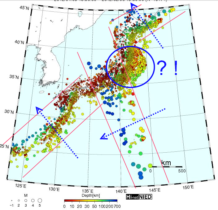
Forget about the nukes. You can clearly see three subduction area here (shallow to deep) but what the heck is happening around THE nuke? That looks almost as if the subduction zone goes the opposite way yet that is not what the scientific papers show.
I never realised how different Japanese is from English
ROFLMAO. They don't exactly look or sound similar do they. Curious that.
Forget about the nukes. You can clearly see three subduction area here (shallow to deep) but what the heck is happening around THE nuke? That looks almost as if the subduction zone goes the opposite way yet that is not what the scientific papers show.
new topics
-
4/27/24 New Jersey Earthquake
Fragile Earth: 4 hours ago -
Fun with extreme paints
Interesting Websites: 6 hours ago -
CIA is alleged to be operat social media troll frms in Kyiv
ATS Skunk Works: 7 hours ago -
Rainbow : Stargazer
Music: 8 hours ago -
I sleep no more.
Philosophy and Metaphysics: 10 hours ago -
Canada caught red-handed manipulating live weather data and make it warmer
Fragile Earth: 10 hours ago
top topics
-
Canada caught red-handed manipulating live weather data and make it warmer
Fragile Earth: 10 hours ago, 16 flags -
Why Files Our Alien Overlords | How We Secretly Serve The Tall Whites
Aliens and UFOs: 12 hours ago, 11 flags -
Curse of King Tuts Tomb Solved
Ancient & Lost Civilizations: 13 hours ago, 9 flags -
CIA is alleged to be operat social media troll frms in Kyiv
ATS Skunk Works: 7 hours ago, 6 flags -
4/27/24 New Jersey Earthquake
Fragile Earth: 4 hours ago, 6 flags -
What allies does Trump have in the world?
ATS Skunk Works: 13 hours ago, 5 flags -
I sleep no more.
Philosophy and Metaphysics: 10 hours ago, 4 flags -
Fun with extreme paints
Interesting Websites: 6 hours ago, 2 flags -
Rainbow : Stargazer
Music: 8 hours ago, 1 flags
active topics
-
University of Texas Instantly Shuts Down Anti Israel Protests
Education and Media • 356 • : DBCowboy -
I sleep no more.
Philosophy and Metaphysics • 14 • : BrotherKinsMan -
4/27/24 New Jersey Earthquake
Fragile Earth • 4 • : LuciusDriftwood -
Ireland VS Globalists
Social Issues and Civil Unrest • 14 • : covent -
Gov Kristi Noem Shot and Killed "Less Than Worthless Dog" and a 'Smelly Goat
2024 Elections • 92 • : cherokeetroy -
Today I am 8
Members • 21 • : randomuser2034 -
Big Storms
Fragile Earth • 19 • : lilzazz -
George Knapp AMA on DI
Area 51 and other Facilities • 40 • : TheDiscoKing -
Silent Moments --In Memory of Beloved Member TDDA
Short Stories • 76 • : RAY1990 -
Why Files Our Alien Overlords | How We Secretly Serve The Tall Whites
Aliens and UFOs • 11 • : TheValeyard