It looks like you're using an Ad Blocker.
Please white-list or disable AboveTopSecret.com in your ad-blocking tool.
Thank you.
Some features of ATS will be disabled while you continue to use an ad-blocker.

Quake Watch 2012
page: 284share:
I "stole" an Excel 2010 file and ran it on my Excel 2007.
One of the feature differences is on 2010 you can make the columns different shades without hours of adjustments necessary to each individual column.
I like the 3D type graphs, still quite limited in the selection of colours though
Numbers Count Graphs 2012
(thumbs)
Chile .................. Columbia
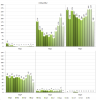
I'll do some more, and try and standardize the style through out for all the other countires on my eqarchives site
damn it I made a mistake on Colombia graph, shows no mag 4's in March, there were 2 of them
I'll go fix that, but won't bother posting the graph here again.
They are on the eqarchives individual country pages at the bottom of the page (and I'll probably make a new "Graph" page as well with them all on it).
One of the feature differences is on 2010 you can make the columns different shades without hours of adjustments necessary to each individual column.
I like the 3D type graphs, still quite limited in the selection of colours though
Numbers Count Graphs 2012
(thumbs)
Chile .................. Columbia


I'll do some more, and try and standardize the style through out for all the other countires on my eqarchives site
edit on 25-12-2012 by muzzy because: (no reason given)
damn it I made a mistake on Colombia graph, shows no mag 4's in March, there were 2 of them
I'll go fix that, but won't bother posting the graph here again.
They are on the eqarchives individual country pages at the bottom of the page (and I'll probably make a new "Graph" page as well with them all on it).
edit on 25-12-2012 by muzzy because: (no reason given)
You have a tag problem on your post Muzzy.
Upgrade to Magnitude 6.1 New Britain region. Papua New Guinea - was 6.0
2 New Mag 6 on the 11th and the 15th
The Molucca Sea Mag 6 on the 11th was documented by Muzzy here showing the various other providers when USGS was @5.8 Mw
The Near Islands Mag 6 on the 15th was documented by ujustneverknow here as a 5.9Mw.
Now we see the benefit of the history these threads/posts provide.
Magnitude: 5.1
DateTime: Tuesday December 25 2012, 17:36:29 UTC
Region: Pakistan
Depth: 10 km
Source: USGS Feed
Magnitude: 5.3
DateTime: Tuesday December 25 2012, 22:44:34 UTC
Region: Black Sea, offshore Georgia
Depth: 13.8 km
Source: USGS Feed
quakes.globalincidentmap.com...
Magnitude 5.3
Date-Time
Tuesday, December 25, 2012 at 22:44:34 UTC
Wednesday, December 26, 2012 at 02:44:34 AM at epicenter
Time of Earthquake in other Time Zones
Location 42.441°N, 41.019°E
Depth 13.8 km (8.6 miles)
Region BLACK SEA, OFFSHORE GEORGIA
Distances 47 km (29 miles) SW of Och'amch'ire, Georgia
62 km (38 miles) WNW of P'ot'i, Georgia
62 km (38 miles) WSW of Gali, Georgia
63 km (39 miles) S of Sokhumi, Georgia
Location Uncertainty horizontal +/- 11.8 km (7.3 miles); depth +/- 6.6 km (4.1 miles)
Parameters NST=216, Nph=216, Dmin=216 km, Rmss=0.92 sec, Gp= 29°,
M-type=body wave magnitude (Mb), Version=6
Source
Magnitude: USGS NEIC (WDCS-D)
Location: USGS NEIC (WDCS-D)
Magnitude: 4.5
DateTime: Tuesday December 25 2012, 22:55:51 UTC
Region: Black Sea, offshore Georgia
Depth: 9.8 km
Source: USGS Feed
Magnitude: 4.6
DateTime: Tuesday December 25 2012, 23:09:32 UTC
Region: southern Xinjiang, China
Depth: 10.7 km
Source: USGS Feed
Magnitude: 4.5
DateTime: Tuesday December 25 2012, 23:09:49 UTC
Region: Kyrgyzstan
Depth: 100 km
Source: CSEM-EMSC Feed
edit on 7/30/2012 by dreamfox1 because:
earthquake.usgs.gov...

WTH, man? I was just coming in to post in that thread! They better return the quake watch '13 thread, it's an annual record of shakin' right in the
most convenient spot, plus oodles of educational info over the year. Obviously, the mod who binned it needs to READ threads before junking them
I guess I'll post the quakes here, the ones that caught my eye:
5.0 77km SW of Padangsidempuan, Indonesia 2012-12-26 14:08:03 0.913°N 98.739°E 77.3
And in the US:
1.5 4km S of Lilbourn, Missouri 2012-12-26 10:27:19 36.553°N 89.611°W 7.1
0.9 3km S of Salina, Utah 2012-12-26 05:09:18 38.928°N 111.859°W 5.8
2.5 19km E of Socorro, New Mexico 2012-12-26 04:32:34 34.087°N 106.682°W 5.0
1.3 4km S of Lilbourn, Missouri 2012-12-26 02:35:56 36.553°N 89.611°W 6.3
2.2 74km NNW of Kayenta, Arizona 2012-12-26 00:34:14 37.375°N 110.490°W -2.9
1.2 4km S of Lilbourn, Missouri 2012-12-25 23:10:55 36.556°N 89.610°W 5.4
0.9 38km ENE of Old Faithful Geyser, Wyoming 2012-12-25 22:15:46 44.575°N 110.371°W 2.7
2.1 38km ENE of Old Faithful Geyser, Wyoming 2012-12-25 21:57:21 44.572°N 110.371°W 4.1
0.5 39km ENE of Old Faithful Geyser, Wyoming 2012-12-25 21:21:23 44.580°N 110.364°W 4.8
1.0 23km NE of Old Faithful Geyser, Wyoming 2012-12-25 21:12:37 44.587°N 110.588°W 6.3
1.5 21km NE of Old Faithful Geyser, Wyoming 2012-12-25 21:09:33 44.595°N 110.633°W 5.2
Old Faithful did a bit of dancing, eh? Same with New Madrid fault, both were hopping just a bit.
Courtesy of the USGS earthquake.usgs.gov...
edit on 12/26/2012 by Nyiah because: (no reason given)
Just in
never recognized one arround there
ok, just watched the history of this area... seems normal.
M5.3 - Ascension Island region 2012-12-26 20:24:26 UTC
Event Time
2012-12-26 20:24:26 UTC
2012-12-26 19:24:26 UTC-01:00 at epicenter
2012-12-26 21:24:26 UTC+01:00 system time
Location
10.432°S 13.170°W depth=9.2km (5.7mi)
Nearby Cities
308km (191mi) SSE of Georgetown, Saint Helena
1745km (1084mi) SSW of Harper, Liberia
1764km (1096mi) SSW of Tabou, Ivory Coast
1768km (1099mi) SSW of Greenville, Liberia
1868km (1161mi) S of Monrovia, Liberia
never recognized one arround there
ok, just watched the history of this area... seems normal.
edit on 26-12-2012 by aLLeKs because: (no reason given)
None of the Networks have this one, the biggest quake Globally in 5 days?????, 6 hours ago
from the Southern Ocean experts LDEO
confirmed by LISS SNZO
whats wrong with these people,as soon as I opened my browser ( set to SNZO) I thought "close to NZ (because of the short P signal), and mid 5ish"
will probably come in on USGS at something around 5.2 eventually, LDEO, using S wave, tend to be a little high on their estimates
2012 12 26 23:02:00.0, -55.75, -144.75, 33.0, [color=rorange]5.6, PACIFIC-ANTARCTIC RIDGE
from the Southern Ocean experts LDEO
confirmed by LISS SNZO
whats wrong with these people,as soon as I opened my browser ( set to SNZO) I thought "close to NZ (because of the short P signal), and mid 5ish"
will probably come in on USGS at something around 5.2 eventually, LDEO, using S wave, tend to be a little high on their estimates
edit on
26-12-2012 by muzzy because: (no reason given)
In a spot I haven't seen anything this big in recently:
5.3 169km E of Oistins, Barbados 2012-12-27 00:36:12 12.966°N 57.975°W 14.0
earthquake.usgs.gov...
5.3 169km E of Oistins, Barbados 2012-12-27 00:36:12 12.966°N 57.975°W 14.0
earthquake.usgs.gov...
reply to post by muzzy
Have you dumped your own LDEO page? I went to have a look at it and it 404ed.
I wanted to compare a few. This one of course may turn up as you say but if it does not then one really needs to know why.
What intrigues me is that it is on the IRIS seismic monitor yet they do not provide data they just collect data from other sources which means SOMEONE has this data, LDEO do surface wave calcs on events they collect from IRIS so the chain
provider---->IRIS---->LDEO
has someone at the head that we do not know about. The quake is not on Australia or New Zealand that I can see, nor is it on ANF (Earthscope) so where has it come from? It seems it is too early for the daily PDE file ETA: try this format instead
Beats me where they got it from!
edit on 27/12/2012 by PuterMan because: (no reason given)
I'm sure this has been spotted by you guys I just thought it was funny that it wasn't showing on Earth Alerts???
5.9 Mag Central California.
www.iris.edu...
5.9 Mag Central California.
www.iris.edu...
reply to post by quedup
That quake is this one I think:
Data sourced from USGS. As to why it is 5.9 on IRIS I have no idea but curious things like that happen more often that you might think.
Here is the seismogram from a station that is just 2.74 miles from the event. B075.PB..EHZ.2012.361
That quake is this one I think:
2012-12-26 11:32:32, 35.970, -120.526, 3.3, 12.0, Central California [Map]
Data sourced from USGS. As to why it is 5.9 on IRIS I have no idea but curious things like that happen more often that you might think.
Here is the seismogram from a station that is just 2.74 miles from the event. B075.PB..EHZ.2012.361
reply to post by PuterMan
yeah I deleted LDEO, I couldn't keep a continuous record running, too many gaps.
yeah I deleted LDEO, I couldn't keep a continuous record running, too many gaps.