It looks like you're using an Ad Blocker.
Please white-list or disable AboveTopSecret.com in your ad-blocking tool.
Thank you.
Some features of ATS will be disabled while you continue to use an ad-blocker.

Quake Watch 2012
page: 270share:
Magnitude 4.6 - JAN MAYEN ISLAND REGION
this is kinda in my neck of the woods,,
earthquake.usgs.gov...
yes its near one of the volcanos that norway owns lol..
this is kinda in my neck of the woods,,
earthquake.usgs.gov...
yes its near one of the volcanos that norway owns lol..
5.9 earthquake, 157km ENE of Angoram, Papua New Guinea. Nov 29 21:10 at epicenter (depth 10km)
2012-11-29 11:10:27 UTC
2012-11-29 21:10:27 UTC+10:00 at epicenter
2012-11-29 06:10:27 UTC-05:00 system time
Location
3.706°S 145.440°E depth=10.0km (6.2mi)
Nearby Cities
157km (98mi) ENE of Angoram, Papua New Guinea
172km (107mi) NNW of Madang, Papua New Guinea
202km (126mi) E of Wewak, Papua New Guinea
262km (163mi) N of Goroka, Papua New Guinea
662km (411mi) NNW of Port Moresby, Papua New Guinea
reply to post by kennvideo
Mag 6 from EMSC and GFZ Potsdam.
Can't break the quiet cycle yet. Need to wait a few more days. Not close enough to 21 Dec.
Mag 6 from EMSC and GFZ Potsdam.
Can't break the quiet cycle yet. Need to wait a few more days. Not close enough to 21 Dec.
If the oil companies claim fracking doesn't cause earthquakes, then they are knowingly suppressing data and are flat out lying. As proof, you need
only look to the Canadian drillers who have admitted the truth.
thetyee.ca...
So for those keeping score, the British and the Canadians have stated that fracking -don't let them say it's only injection- injection causes them as well, but- fracking causes earthquakes. And therefore, you shouldn't be conducting the practice in seismic areas. And, if the freakin' earthquake keeps shaking, you'd better think about stopping.
"I'm yelling at you Oklahoma!!!"
nudge nudge, wink wink
If you check, they've had a bunch this week.
Something different.
www.msnbc.msn.com...
I am almost complety 100% sure that there is a gobal mechanism to our shifting crust. Yes, the plaste are moving and have direct local consequences. But, more to the point, each plate is acting on adjacent, and on far away seismic systems. ie Alaska rearranges Yellowstone, the double 8's off Sumatra, and now it seems we have the 8.8M in Chile shuffling the deck.
We are experiencing a major seismic storm. It really started around 2004 and is continuing today. This cluster is not slowing or getting ready to relax. No. I figure we're miday through. For whatever reason. And I don't want to argue what's next in way of a big thrust. I think the odds are on Cascadia. But. It doesn't matter much with regards to a bigger issue. These coming siemic shifts will cause destruction and distress. Mostly, the danger lay in the tsunami. But even this will pale in comparison to what will follow. Sorry for being such a downer. But I've been working on a big puzzle lately and the noodle is over cooked and leaking through the colander.
After all is said and done. These seismic shifts will usher in the next phase. The volcano. So, this means my debate with Puterman about climate change is distraction and a red herring. Yes, it's getting warmer. But at the end of the day, (you ever notice that lots of middle east politicians and analyists use that term) at the end of the day, it's going to get a whole lot cooler.
Santorini 1623 bce
Krakatoa 535 ad (someone is overlooking this one- like mostly everyone)
minor players
krakatoa 1883
tambora 1812
www.ees1.lanl.gov...
edit on 29-11-2012 by ericblair4891 because: (no reason given)
edit on 29-11-2012 by ericblair4891 because: (no reason
given)
edit on 29-11-2012 by ericblair4891 because: (no reason given)
reply to post by alysha.angel
also regard that jan mayen is an well known "hotspot".....!
en.wikipedia.org...
also regard that jan mayen is an well known "hotspot".....!
en.wikipedia.org...
edit on 29-11-2012 by ressiv because: (no reason given)
reply to post by kennvideo
There is something distinctly odd about that quake entry
earthquake.usgs.gov...
There is no travel times map, no phase data and no moment tensors other than the initiate one on the P wave. Why are they not publishing anything on it? Will go to 6? Are they just holding off because their lap dogs are disputing it?
This will be quick and painless. I hope.
It seems my mind is slipping to volcanoes again. It's Guatemala's fault. It's seismic off shore. And, the volcano is acting up. I so much wish I could rant about the fact it burped with a full moon and Jupiter strolling together above. All a coininky dink?
worldnews.nbcnews.com...
I should really shift gears and post on volcano watch. So, I really should be expanding my argument there. Coinkodently, I had stumbled upon a describtion of a 1902 eruption today as I research other things. Like, the 13th Century, and the 6th. and.... wow. there's no coinkydent anymore. least not with me. i just erased some stupidity. edit.
Yes, Oklahoma. Four earthquakes there today. By comparison, let's look at Yellowstone. (jepardy theme song)
Yellowstone has had two. So, Oklahoma has had 200% more earthquakes than an active volcano.
been pretty quiet down here lately, been ages since we had a 5
seems to be picking up though, 6 fours in the last two days, all NE of the North ISland
Matata .................. haven't seen that name for a while, has been a very active area in the past.
well GNS has that one near Matata, the others plotted it miles away
4.5mb UGS
4.6ML GNS
4.7mb GFZ
deepish
haven't got time to map NZ this morning, later
still pumping them out at BOZBURUN ACIKLARI-MUGLA (DODECANESE ISLANDS)
seems to be picking up though, 6 fours in the last two days, all NE of the North ISland
2012-11-29T10:44:23.717 -36.5059 178.9643 4.71 8.8 Auckland-Coromandel-Whakatane Seamount
2012-11-30T02:36:06.032 -37.8921 176.7063 4.62 189.5 147B Mimiha Rd, Matata
2012-11-29T14:06:09.371 -34.5117 179.3555 4.22 195.3 South Of Kermadec Islands
2012-11-29T08:13:01.469 -37.2318 178.6404 4.2 157.8 Matakoa Valley-Lottin Ridge- East Cape Ridge
2012-11-29T10:40:35.932 -35.9326 179.4873 4.04 328.1 Whangarei-Rumble3-Healy
2012-11-29T00:33:08.043 -35.9912 177.9346 4.01 381.1 Whangarei-Rumble3-Healy
Matata .................. haven't seen that name for a while, has been a very active area in the past.
well GNS has that one near Matata, the others plotted it miles away
4.5mb UGS
4.6ML GNS
4.7mb GFZ
deepish
haven't got time to map NZ this morning, later
still pumping them out at BOZBURUN ACIKLARI-MUGLA (DODECANESE ISLANDS)
edit on
30-11-2012 by muzzy because: (no reason given)
reply to post by muzzy
Been very quiet everywhere today
Biggie tomorrow????????
Been very quiet everywhere today
Prov,Date/Time UTC,Latitude,Longitude,Magnitude,Depth(Km),Location
usgs,2012-11-30 19:39:29, 27.187, 88.209, 4.7, 15.9, Sikkim. India
usgs,2012-11-30 17:18:52, 43.801, 147.285, 4.9, 61.8, Kuril Isls.
usgs,2012-11-30 11:42:58, 39.162, 143.668, 4.8, 26.2, Off E. Coast Of Honshu. Japan
usgs,2012-11-30 11:20:36, -18.793, -175.588, 5.5, 181.8, Tonga
usgs,2012-11-30 11:00:38, 55.590, 160.193, 4.6, 49.0, Kamchatka Peninsula. Russia
usgs,2012-11-30 09:02:51, -15.256, -72.764, 4.5, 117.1, Southern Peru
usgs,2012-11-30 06:48:20, 48.142, 155.003, 4.8, 45.4, Kuril Isls.
usgs,2012-11-30 02:36:07, -38.170, 176.771, 4.5, 183.9, N. Isl Of Nz
Biggie tomorrow????????
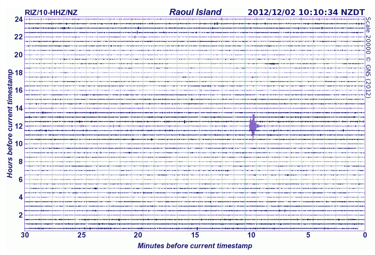
UPDATE to post by PuterMan
The calm before the storm?
The image is way too big for ATS - nearly 1.5 Mb - but I wanted to record the flat calm on LISS before all hell breaks loose.
I made a post to preserve the list as it is right now. The 'lost' hurricane of Greenland shows and something odd about the Kermedecs.
The calm before the storm?
The image is way too big for ATS - nearly 1.5 Mb - but I wanted to record the flat calm on LISS before all hell breaks loose.
I made a post to preserve the list as it is right now. The 'lost' hurricane of Greenland shows and something odd about the Kermedecs.
The Kermedecs recorder looks as if it is either faulty or if it was in Yellowstone I would say it had ice on the transmitter but I doubt if that is
the case in this instance.
I can't imagine that 29°S at an elevation of 60 metres (official) or even 215 metres (Google Earth) would be cold enough to cause ice on the transmitter. Over to you NZ folks on that one.
I can't imagine that 29°S at an elevation of 60 metres (official) or even 215 metres (Google Earth) would be cold enough to cause ice on the transmitter. Over to you NZ folks on that one.
reply to post by PuterMan
quite likely a fault with the LISS system, assuming they use the same siesmograph machine as GNS does up there
quite likely a fault with the LISS system, assuming they use the same siesmograph machine as GNS does up there
a muzzy mega map upload
for those who have restricted ISP capacity or can't be bothered to wait for the pages on eqarchives to load 11 months worth of data before you can see the first map, here are a few of the Nov maps just uploaded this morning
warning: the mag1+ maps and the Pollino map are still over 1MB each
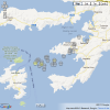
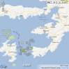
New Zealand 3+ interactive map
Greece 3+ interactive map
All quakes Greece mag 1 + interactive map 1559 events
Italy 3+ interactive map
Italy mag 1+ interactive map, 1385 events, (those fellas need all the archiving help they can get)
The Pollino, Italy 25/10/2012 mag 5.0 quake aftershocks continue, have been 1170 now 36 days, interactive map of those
Turkey 3+ map
I can't do a Turkey mag1+, as I missed the first 8 days downloads (keep forgetting to do that)
going to go over Bozburun Aciklari Mulga Swarm, Turkey (Dodecanese Islands) again today, getting mixed results from NOA and KOERI, I'll probably stick with koeri as they seem to have more events, quite a difference in latitude for the mag 3+'s anyway, and I just noticed the name shows up 09/11/2012 too, way before I thought the swarm started on 25/11
for those who have restricted ISP capacity or can't be bothered to wait for the pages on eqarchives to load 11 months worth of data before you can see the first map, here are a few of the Nov maps just uploaded this morning
warning: the mag1+ maps and the Pollino map are still over 1MB each
New Zealand 3+ interactive map
Greece 3+ interactive map
All quakes Greece mag 1 + interactive map 1559 events
Italy 3+ interactive map
Italy mag 1+ interactive map, 1385 events, (those fellas need all the archiving help they can get)
The Pollino, Italy 25/10/2012 mag 5.0 quake aftershocks continue, have been 1170 now 36 days, interactive map of those
Turkey 3+ map
I can't do a Turkey mag1+, as I missed the first 8 days downloads (keep forgetting to do that)
going to go over Bozburun Aciklari Mulga Swarm, Turkey (Dodecanese Islands) again today, getting mixed results from NOA and KOERI, I'll probably stick with koeri as they seem to have more events, quite a difference in latitude for the mag 3+'s anyway, and I just noticed the name shows up 09/11/2012 too, way before I thought the swarm started on 25/11


edit on 1-12-2012 by muzzy because: (no reason given)
Mag 6.2 6.4 Vanuatu
GFZ Potsdam Mag 6.2
Automatic not confirmed.
(ETA: GFZ now at Mag 6.3)
EMSC in at Mag 6.2 (Now raised to 6.4)
Magnitude 6.4 - Vanuatu
Locat ion in Google Maps
- Date-Time: Sunday, December 02, 2012 @ 00:54:23 UTC
- Earthquake location: 17.012°S, 167.626°E,
- Earthquake depth: 34.1 km
- Distances:
101km (62mi) SSE of Lakatoro, Vanuatu
108km (67mi) NW of Port-Vila, Vanuatu
170km (105mi) SSE of Luganville, Vanuatu
433km (269mi) N of We, New Caledonia
581km (361mi) NNE of Dumbea, New Caledonia
- Event ID: usc000e26u
Derived from Event Data Source: USGS
Powered by QVSData
EMSC also gone up to 6.4
edit on 1/12/2012 by PuterMan because: (no reason given)
UPDATE to post by PuterMan
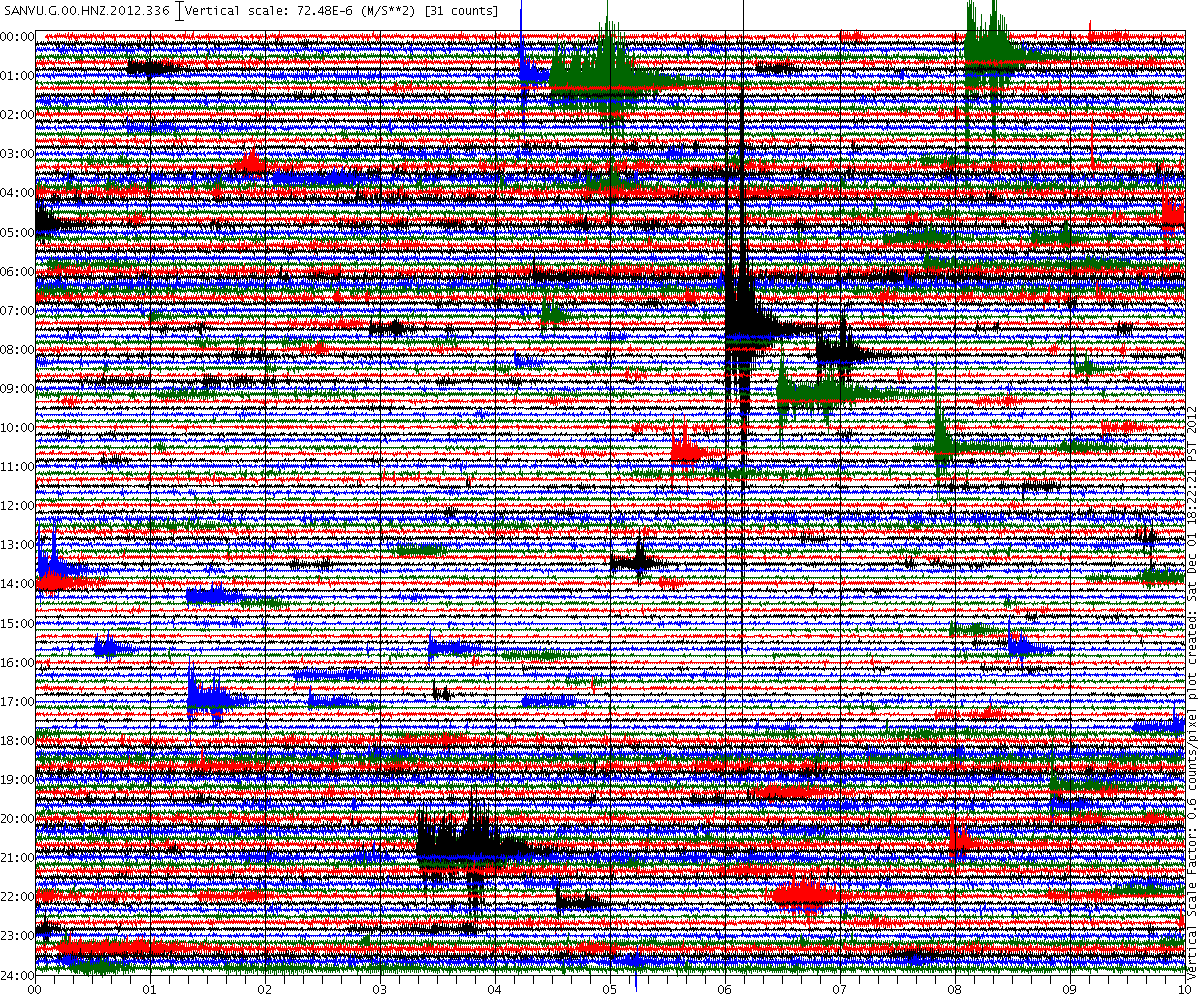
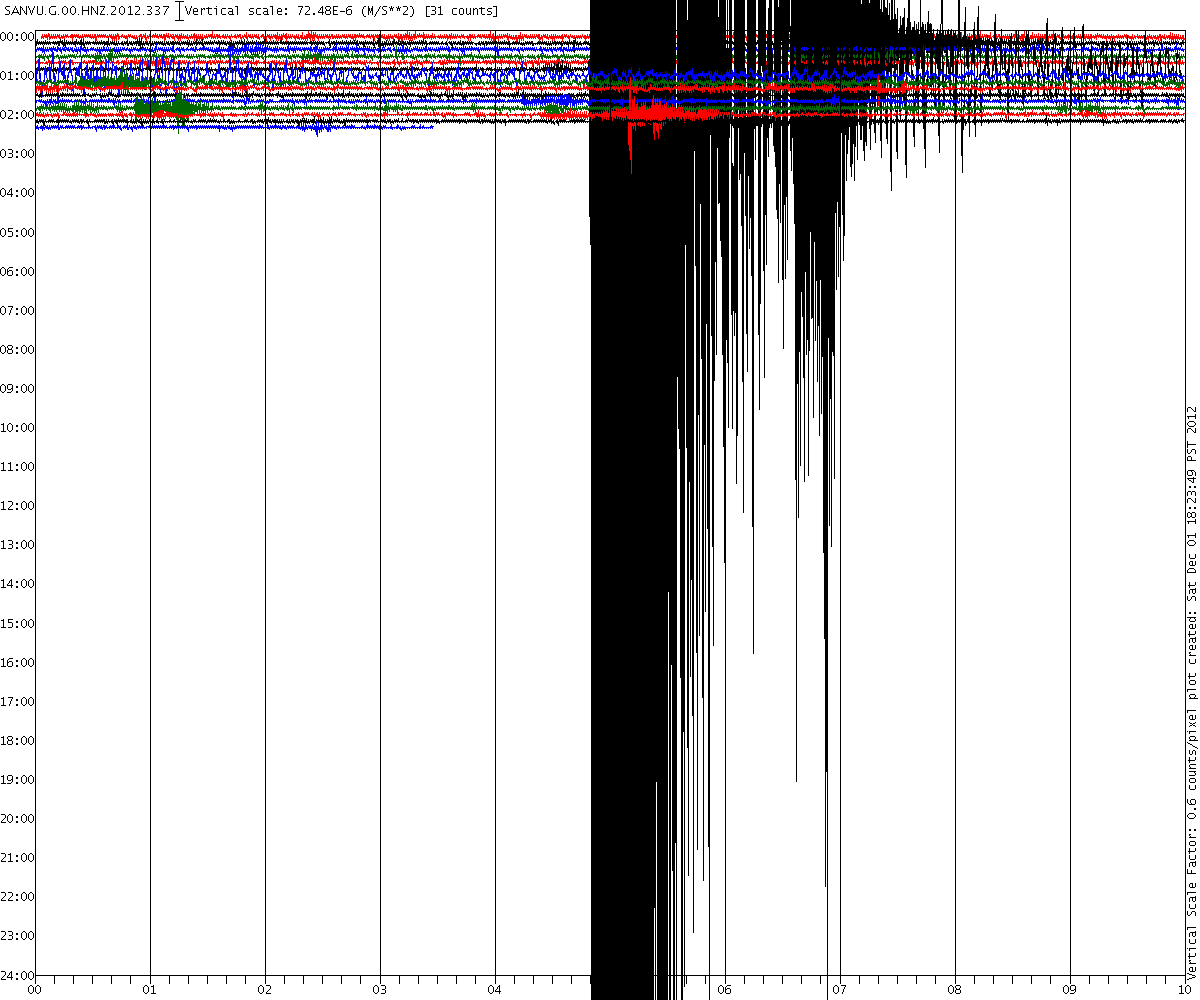
Here is the SANVU (Vanuatu) recorder for yesterday. Busy isnt it
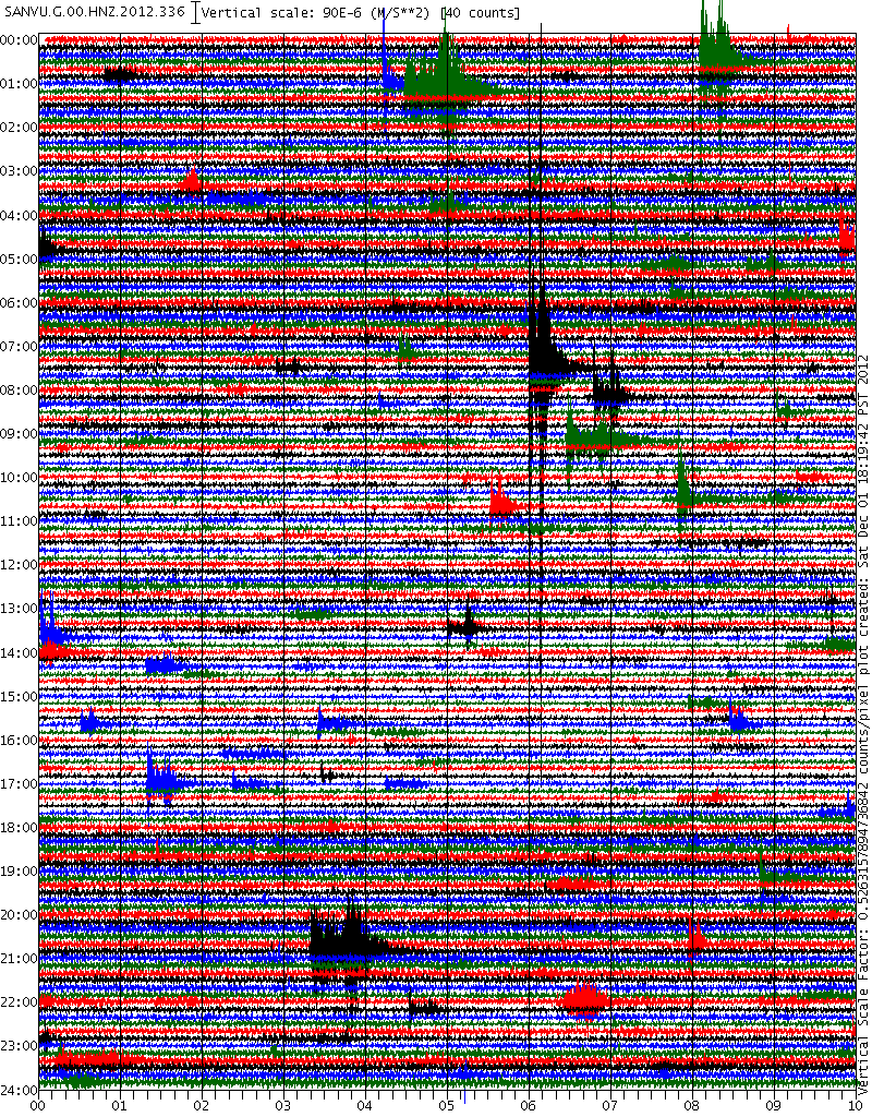
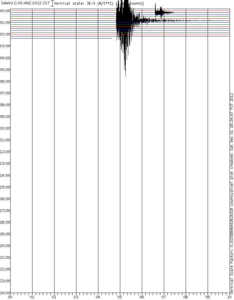
And here is the Mag 6 today (UTC)
Does not look much bigger does it? But what happens if I standardise the scale.
Here is yesterday at 1000 x 1200 and 0.6 vertical scale
And here - at the same scale - is today

Take a look at the size of the 00:16:45 on the correctly scaled chart for today. Where is THAT in the listings?
Here is the SANVU (Vanuatu) recorder for yesterday. Busy isnt it
And here is the Mag 6 today (UTC)
Does not look much bigger does it? But what happens if I standardise the scale.
Here is yesterday at 1000 x 1200 and 0.6 vertical scale
And here - at the same scale - is today
Take a look at the size of the 00:16:45 on the correctly scaled chart for today. Where is THAT in the listings?
edit on 1/12/2012 by PuterMan because: (no reason given)
Originally posted by muzzy
Turkey 3+ map
I can't do a Turkey mag1+, as I missed the first 8 days downloads (keep forgetting to do that)
oh yes I can
I've found the micro/ very minors today.
You click on the "View on GoogleMaps" blue text above the list, and then when that eventually loads, click on the little icon in the bottom right corner of the map "Export List" it goes back to Jan 2003.
Its just 3's for the first few months, but will be real handy , I'll be able to do a final "Van" update and I noticed a few others such as a 6.4 and a big clump of aftershocks at Bingol (east of Van) in May 2003 just for starters,
Hmmmm 9 years x 12 month = 108 maps
Found all that while doing this
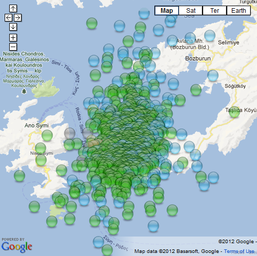
Bozburun Aciklari, Mulga, Turkey (Dodecanese Islands) Swarm 08/11 to 02/12/2012 interactive map
I did a page on it
A Swarm of earthquakes has been occuring in the Mediterranean Sea near Bozburun Aciklari in the Province of Mulga, Turkey.
The area is also known as the Dodecanese Islands by the Greeks, and is north of the island of Rhodes.
at the time mark of 543 hours (22.6 days) since the first event on 08/11/2012 at 22:06:38hrs UTC, a 2.3 ML quake at Lat/Long 36.5968, 27.9383, there have been 794 quakes,
mag1=216, mag2=551, mag3=21,
and 6 quakes over magnitude four have been recorded
Mag, When, time mark since swarm started [hh:mm:ss]
4.8, 26/11/2012 17:35:41, 427:29:03
4.4, 24/11/2012 21:04:16, 382:57:38
4.3, 24/11/2012 21:31:14, 383:24:36
4.0, 09/11/2012 04:46:14, 6:39:36
4.0, 24/11/2012 21:35:21, 383:28:43
4.0, 25/11/2012 08:51:45, 394:45:07
Total energy released= 447.281 tons of TNT
eqarchives
FWIW I was wondering what the translation for Aciklari was, did a GT and it means " deficits" in English
I like it Bozburun Deficits, sounds a bit like the Deccan Traps in India
map image for those who aren't interactive
edit on 1-12-2012 by muzzy because: (no reason given)
This one is smack dab on the subduction zone.
Would not surprise me at all for this area to give a 7+ as an early Christmas present!
earthquake.usgs.gov...
Would not surprise me at all for this area to give a 7+ as an early Christmas present!
earthquake.usgs.gov...
UPDATE to post by PuterMan
I am wondering why USGS put this Vanuatu quake up to 6.4, followed swiftly by EMSC doing the same.
If you look at the Centroid and Body wave moment tensors they are 6.2 and 6.2 respectively. The 6.4 is derived from the Mwb which averages at 6.34 based on 69 counts. For starters why wind that up to 6.4, and secondly GFZ Potsdam have now come down to 6.1. There is also an Mwc of 6.2
Once the troops get back in on Monday this may go down.
Ouch! I just ran a 30 day check
Source:The QVSData program.
That is a lot of changes I have to catch up with!!!
Magnitude 6+ earthquakes downgraded: 2
Magnitude 5 or 6+ earthquakes upgraded: 7
------------------------------------------------------------------
Downgraded quake
us|c000du43|?|Saturday, November 17, 2012 05:12:56 UTC|-18.381|-172.32|5.9|10|?|178km E of Neiafu, Tonga
Downgraded quake
ak|10598710|?|Monday, November 12, 2012 20:42:16 UTC|57.5884|-142.8764|5.8|10.9|?|248km S of Cape Yakataga, Alaska
------------------------------------------------------------------
Upgraded quake
us|c000duti|?|Monday, November 19, 2012 09:44:34 UTC|-5.734|151.606|6|10.1|?|163km E of Kimbe, Papua New Guinea
Upgraded quake
us|c000dtr7|?|Friday, November 16, 2012 18:12:39 UTC|49.273|155.476|6.5|29|?|163km SSW of Severo-Kuril'sk, Russia
Upgraded quake
us|c000dsyl|?|Thursday, November 15, 2012 09:20:23 UTC|18.407|-100.373|6.1|60.8|?|9km E of Tlalchapa, Mexico
Upgraded quake
us|c000dski|?|Wednesday, November 14, 2012 19:02:05 UTC|-29.122|-71.204|6.2|59.2|?|75km SW of Vallenar, Chile
Upgraded quake
us|c000drlb|?|Tuesday, November 13, 2012 04:31:27 UTC|-45.744|-77.142|6.1|9.7|?|Off the coast of Aisen, Chile
Upgraded quake
us|2012hwa4|?|Monday, November 12, 2012 20:42:14 UTC|57.797|-142.809|6.3|9|?|253km S of Cape Yakataga, Alaska
Upgraded quake
us|c000dqg4|?|Saturday, November 10, 2012 14:57:50 UTC|-8.865|-75.065|6|129|?|51km SSW of Campoverde, Peru
Log closed 020804
------------------------------------------------------------------
Source:The QVSData program.
That is a lot of changes I have to catch up with!!!
new topics
-
German city in chaos as 'extremist' march sees calls for 'caliphate' and ISIS-style flags
Mainstream News: 1 hours ago -
College protesters want amnesty.
US Political Madness: 3 hours ago -
Shocking moment four men 'try to force Jewish pedestrian into car boot' in North London
Breaking Alternative News: 6 hours ago -
The 'Censorship-Industrial Complex'. It is coming to a nation state near you, any time now...
New World Order: 7 hours ago -
BREAKING: Astrazeneca admits for the first time its vaccine can cause deaths and serious injuries
Medical Issues & Conspiracies: 10 hours ago
top topics
-
New Bombshell Evidence Strongly Suggests Trump was Set Up in Classified Docs Saga
US Political Madness: 15 hours ago, 37 flags -
BREAKING: Astrazeneca admits for the first time its vaccine can cause deaths and serious injuries
Medical Issues & Conspiracies: 10 hours ago, 15 flags -
Shocking moment four men 'try to force Jewish pedestrian into car boot' in North London
Breaking Alternative News: 6 hours ago, 11 flags -
German city in chaos as 'extremist' march sees calls for 'caliphate' and ISIS-style flags
Mainstream News: 1 hours ago, 11 flags -
College protesters want amnesty.
US Political Madness: 3 hours ago, 5 flags -
The 'Censorship-Industrial Complex'. It is coming to a nation state near you, any time now...
New World Order: 7 hours ago, 2 flags
active topics
-
The 'Censorship-Industrial Complex'. It is coming to a nation state near you, any time now...
New World Order • 4 • : Cvastar -
Hurt my hip; should I go see a Doctor
General Chit Chat • 28 • : mysterioustranger -
College protesters want amnesty.
US Political Madness • 16 • : nugget1 -
German city in chaos as 'extremist' march sees calls for 'caliphate' and ISIS-style flags
Mainstream News • 8 • : DBCowboy -
Do you name your cars ?
General Chit Chat • 17 • : mysterioustranger -
BREAKING: Astrazeneca admits for the first time its vaccine can cause deaths and serious injuries
Medical Issues & Conspiracies • 9 • : mysterioustranger -
5 probed after 18-year old girl dies as a result of having the COVID jab
Diseases and Pandemics • 22 • : 320MPH -
Shocking moment four men 'try to force Jewish pedestrian into car boot' in North London
Breaking Alternative News • 38 • : dothedew -
Expert Says Parents Should Ask Babies Permission to Change Nappies.
General Chit Chat • 46 • : FlyersFan -
New Bombshell Evidence Strongly Suggests Trump was Set Up in Classified Docs Saga
US Political Madness • 50 • : xuenchen