It looks like you're using an Ad Blocker.
Please white-list or disable AboveTopSecret.com in your ad-blocking tool.
Thank you.
Some features of ATS will be disabled while you continue to use an ad-blocker.

Quake Watch 2012
page: 248share:
Reference for Mw6.8 ± 0.1 stress on Húsavík Flatey Fault (HFF)
fulltext(accepted version, not 'of record') hosted at Sabrina Metzger's ETH Zürich page
www.n.ethz.ch/~smetzger/download/GJI_accepted.pdf :
onlinelibrary.wiley.com/doi/10.1111/j.1365-246X.2011.05176.x/abstract
dx.doi.org/10.1111/j.1365-246X.2011.05176.x
fulltext(accepted version, not 'of record') hosted at Sabrina Metzger's ETH Zürich page
www.n.ethz.ch/~smetzger/download/GJI_accepted.pdf :
onlinelibrary.wiley.com/doi/10.1111/j.1365-246X.2011.05176.x/abstract
dx.doi.org/10.1111/j.1365-246X.2011.05176.x
Locking depth and slip-rate of the Húsavík Flatey fault, North Iceland, derived from continuous GPS data 2006–2010
Sabrina Metzger 1,
Sigurjón Jónsson 2,
Halldór Geirsson 3,4
Article first published online: 23 SEP 2011
DOI: 10.1111/j.1365-246X.2011.05176.x
Geophysical Journal International
Volume 187, Issue 2, pages 564–576, November 2011
Author Information
1 Institute of Geophysics, ETH Zürich, Sonneggstrasse 5, 8092 Zürich, Switzerland. E-mail: [email protected]
2 King Abdullah University of Science and Technology (KAUST), Thuwal, Saudi Arabia
3 The Pennsylvania State University, University Park, PA, USA
4 Icelandic Meteorological Office (IMO), Reykjavík, Iceland
Publication History
Issue published online: 14 OCT 2011
Article first published online: 23 SEP 2011
Accepted 2011 July 29. Received 2011 June 29; in original form 2011 March 11
Keywords:
Time series analysis;
Satellite geodesy;
Radar interferometry;
Oceanic transform and fracture zone processes;
Kinematics of crustal and mantle deformation
SUMMARY
Located at the northern shore of Iceland, the Tjörnes Fracture Zone (TFZ) is a 120 km offset in the mid-Atlantic Ridge that connects the offshore Kolbeinsey Ridge to the on-land Northern Volcanic Zone. This transform zone is seismically one of the most active areas in Iceland, exposing the population to a significant risk. However, the kinematics of the mostly offshore area with its complex tectonics have not been adequately resolved and the seismic potential of the two main transform structures within the TFZ, the Grímsey Oblique Rift (GOR) and the Húsavík Flatey Fault (HFF) in particular, is not well known.
In summer 2006, we expanded the number of continuous GPS (CGPS) stations in the area from 4 to 14. The resulting GPS velocities after four years of data collection show that the TFZ accommodates the full plate motion as it is predicted by the MORVEL plate motion model. In addition, ENVISAT interferograms reveal a transient uplift signal at the nearby Theistareykir central volcano with a maximum line-of-sight uplift of 3 cm between summers of 2007 and 2008. We use a combination of an interseismic backslip and a Mogi model in a homogeneous, elastic half-space to describe the kinematics within the TFZ. With a non-linear optimization approach we fit the GPS observations and estimate the key model parameters and their uncertainties, which are (among others) the locking depth, the partition of the transform motion between the two transform structures within the TFZ and the slip rate on the HFF.
We find a shallow locking depth of 6.3+1.7− 1.2 km and transform motion that is accommodated 34 ± 3 per cent by the HFF and 66 ± 3 per cent by the GOR, resulting in a slip velocity of 6.6 ± 0.6 mm yr−1 for the HFF. Assuming steady accumulation since the last two large M6.5 earthquakes in 1872 the seismic potential of the fault is equivalent to a Mw6.8 ± 0.1 event.
(...)
The magnitude estimation of the accumulated moment along
the HFF of Mw = 6.8 ± 0.1 is based on four assumptions: (1)
Complete stress relaxation by the 1872 Mw = 6.5 earthquakes and
steady stress accumulation since then, (2) uniform slip rate and a
constant locking depth, (3) a rupture along the whole total fault
plane with a dimension constrained by the locking depth and (4) the
fault model length, which is the sum of the segments B and C in
Fig. 7. In fact, the onshore segment C ends within the Theistareykir
fissure swarm and is ∼18 km shorter than the model segment.
Using eqs (4) and (5) with the adapted length reduces the magnitude
estimation only within the rounding precision (Mw ± 0.05). Also,
the stress accumulation on HFF might have been influenced by
the Krafla rifting episode 1975–1984 that appears to have reduced
the seismicity on the eastern end of the fault (Rögnvaldsson et al.
1998). Another fact that might be taken into account to estimate the
potential devastating energy would be the direction of rupture. If this
potential event would initiate at the northwestern end of the fault,
the rupture would propagate ‘towards’ Húsavík and the surrounding
farms, which causes a superposition and thus enhancement of the
surface waves.
(...)
7 CONCLUSION
The CGPS time-series presented in this paper covers the whole
TFZ (150 km by 100 km) in North Iceland expanding the existing
network from 4 to 14 stations. The resulting GPS velocities from
4 yr of data show clearly the transformmotion in the TFZ and the full
plate spreading between the North American and the Eurasian Plate.
The transform motion is accommodated by the HFF and the GOR
in a ratio of 34 per cent/66 per cent with an uncertainty of ±3 per
cent. In addition, the GPS velocities show influence from uplift
at Theistareykir central volcano, which likely is caused by magma
accumulation at ∼8.5 km depth. We used a combined backslip and
Mogi source model to describe the surface deformation as seen
with the CGPS data, and for the first time key parameters of the
kinematics of the TFZ were estimated with uncertainties.
(...)
edit on 26-10-2012 by wujotvowujotvowujotvo because: (no reason given)
Just had another one here in Gippsland, Australia.
Not very big, only a 2.8. But its about the 400th since the big one a few months ago and this time, a little desturbing.
The depth of the original 5.6 was 10km, this latest one to hit was at 0.0km.Since the large one they have been getting visibly shallower over time.
Understanding the type of fault lines that criss-cross the Gippsland region, this could be the worst case scenario building up.
Gippy's faults are "thrust" faults. Meaning that the eastern side of the AU plate is relletively thin and pourus, allowing magma and pressure from the mantle access to push up in places. This is the mountain building type of activity that created the Australian Alpine region and the great divide. The whole of gippsland is in an active mountain building phase and in some places, the ground has been raised as much as 10m in the last 100k years.
There are over 40 potentially active volcanoes in Western Victoria and Eastern SA.
Having activity this close to the surface is highly disturbing for me, knowing that these faults were created by upward movement of magma, which caused the surface to fracture and form faults. If EQ activity is at 0km, this ccould be the start of something monsterous..
edit on
10/27/2012 by Ironclad because: (no reason given)
reply to post by Ironclad
Geez Mate, there isn't a quieter place in the World for earthquakes and erupting volcanoes than Australia.
If you can put up with the Fires and the Flies and the PM, I'd be counting my blessings and just get on with the Rugby training
400 quakes since the 5.6 eh?
A link to this data anywhere ?
Geez Mate, there isn't a quieter place in the World for earthquakes and erupting volcanoes than Australia.
If you can put up with the Fires and the Flies and the PM, I'd be counting my blessings and just get on with the Rugby training
400 quakes since the 5.6 eh?
A link to this data anywhere ?
edit on 27-10-2012 by muzzy because: (no reason given)
125 hour aftershock report for the
San Andreas Fault 26km ENE of King City, California, 5.3Mw, 21/10/2012
143 aftershocks, mostly mag 1-2, has elapsed time on each event tag
screenshot
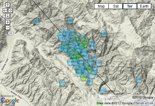
I also did a 564 hours (3 weeks) fore shock map too, new idea, just in case anything was obvious and the scientists missed it ( can't see anything that causes concern, looks like background activity), has the elapsed time prior to the 5.3 on each tag.
and an ANSS seismic History that goes back to 1932.(searched to 1800) with new calc. on each tag of how far before in years they were.
San Andreas Fault 26km ENE of King City, California, 5.3Mw, 21/10/2012
143 aftershocks, mostly mag 1-2, has elapsed time on each event tag
screenshot
I also did a 564 hours (3 weeks) fore shock map too, new idea, just in case anything was obvious and the scientists missed it ( can't see anything that causes concern, looks like background activity), has the elapsed time prior to the 5.3 on each tag.
and an ANSS seismic History that goes back to 1932.(searched to 1800) with new calc. on each tag of how far before in years they were.
Felt this one early this morning, just a jolt
Public ID 2012p812341
Universal Time October 27 2012 at 13:35:44
NZ Daylight Time Sunday, October 28 2012 at 2:35:44 am
Latitude, Longitude -40.14, 174.87
Intensity ? moderate
Focal Depth 34 km
Magnitude 4.4
Location 30 km south-west of Wanganui
www.geonet.org.nz...
edit on 27-10-2012 by muzzy because: took out the h in Whanganui because
thats how its said, not Fonganui
Hmm is it me or is it getting very active today ????
Magnitude: 5.5
DateTime: Saturday October 27 2012, 20:13:01 UTC
Region: New Britain region, Papua New Guinea
Depth: 22.7 km
Source: USGS Feed
Magnitude: 5.1
DateTime: Saturday October 27 2012, 20:14:59 UTC
Region: southeast of the Loyalty Islands
Depth: 35.7 km
Source: USGS Feed
Magnitude: 5.2
DateTime: Saturday October 27 2012, 20:14:55 UTC
Region: Southeast Of Loyalty Islands
Depth: 2 km
Magnitude: 4.9
DateTime: Saturday October 27 2012, 20:55:31 UTC
Region: Pagan region, Northern Mariana Islands
Depth: 77.6 km
Source: USGS Feed
Magnitude: 4.7
DateTime: Saturday October 27 2012, 20:56:46 UTC
Region: Tonga
Depth: 355.6 km
Source: USGS Feed
Magnitude: 4.7
DateTime: Saturday October 27 2012, 21:10:23 UTC
Region: Molucca Sea
Depth: 56 km
Magnitude: 4.3
DateTime: Saturday October 27 2012, 21:10:41 UTC
Region: Ceram Sea, Indonesia
Depth: 35 km
Source: USGS
Magnitude: 4.4
DateTime: Saturday October 27 2012, 21:17:01 UTC
Region: Banda Sea
Depth: 621.9 km
Source: USGS Feed
Magnitude: 4.8
DateTime: Saturday October 27 2012, 22:23:15 UTC
Region: Bougainville region, Papua New Guinea
Depth: 62.1 km
Source: USGS Feed
edit on 7/30/2012 by dreamfox1 because: ???
edit on 7/30/2012 by dreamfox1 because:
quakes.globalincidentmap.com...
reply to post by dreamfox1
Well now, since you asked, you have to forgive me if I say it is you. Mag 4.5+ global numbers are steady over the past 7 days.
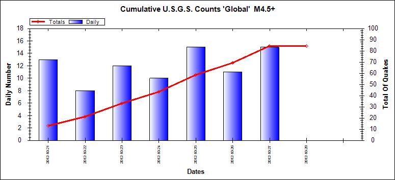
ETA: And just for good measure, the month to date.
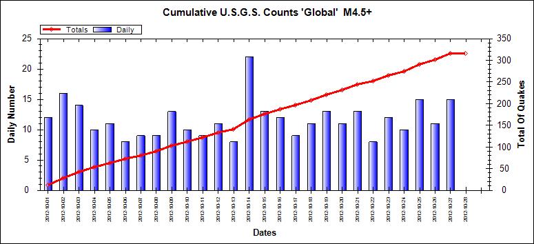
Well now, since you asked, you have to forgive me if I say it is you. Mag 4.5+ global numbers are steady over the past 7 days.
ETA: And just for good measure, the month to date.
edit on 27/10/2012 by PuterMan because: (no reason given)
ALERT
Magnitude: 7.1
DateTime: Sunday October 28 2012, 03:04:11 UTC
Region: Queen Charlotte Islands, Canada region
Depth: 19 km
Source: USGS Feed
Magnitude: 7.1
DateTime: Sunday October 28 2012, 03:04:11 UTC
Region: Queen Charlotte Islands, Canada region
Depth: 19 km
Source: USGS Feed
edit on 7/30/2012 by dreamfox1 because: (no reason given)
With this AND Hurricane Sandy it looks like Mother Earth is getting pissed...:
7.1 earthquake, 128km S of Masset, Canada. Oct 27 20:04 at epicenter (depth 19km).
2012-10-28 03:04:11 UTC
2012-10-27 20:04:11 UTC-07:00 at epicenter
2012-10-27 23:04:11 UTC-04:00 system time
Location
52.863°N 131.942°W depth=19.0km (11.8mi)
Nearby Cities
128km (80mi) S of Masset, Canada
194km (121mi) SW of Prince Rupert, Canada
287km (178mi) SW of Terrace, Canada
562km (349mi) NW of Campbell River, Canada
625km (388mi) SSE of Juneau, Alaska
edit on 27-10-2012 by kennvideo because: add
From the USGS (just accidentally erased the address field, y'all know the address anyway)
Whoa, WHAT??
7.1 128km S of Masset, Canada 2012-10-28 03:04:11 52.863°N 131.942°W 19.0
Whoa, WHAT??
Revised (7.1 -> 7.7): 7.7 earthquake, 139km S of Masset, Canada. Oct 27 20:04 at epicenter (depth 9.9km)
2012-10-28 03:04:08 UTC
2012-10-27 20:04:08 UTC-07:00 at epicenter
2012-10-27 23:04:08 UTC-04:00 system time
Location
52.774°N 131.843°W depth=9.9km (6.2mi)
Nearby Cities
139km (86mi) S of Masset, Canada
199km (124mi) SSW of Prince Rupert, Canada
288km (179mi) SW of Terrace, Canada
551km (342mi) NW of Campbell River, Canada
636km (395mi) SSE of Juneau, Alaska
edit on 27-10-2012 by kennvideo because: info
Originally posted by kennvideo
Revised (7.1 -> 7.7): 7.7 earthquake, 139km S of Masset, Canada. Oct 27 20:04 at epicenter (10m ago, depth 9.9km)
Magnitude 7.7 (Preliminary magnitude — update expected within 15 minutes)
Date-Time
Sunday, October 28, 2012 at 03:04:08 UTC
Saturday, October 27, 2012 at 08:04:08 PM at epicenter
Location 52.774°N, 131.843°W
Depth 9.9 km (6.2 miles) set by location program
Region QUEEN CHARLOTTE ISLANDS REGION
Distances
199 km (123 miles) SSW (212°) from Prince Rupert, BC, Canada
262 km (163 miles) S (184°) from Metlakatla, AK
278 km (173 miles) SSE (166°) from Hydaburg, AK
722 km (449 miles) NW (306°) from Vancouver, British Columbia, Canada
Location Uncertainty Error estimate not available
Parameters NST= 11, Nph=0, Dmin=0 km, Rmss=0 sec, Gp=202°,
M-type="moment" magnitude from initial P wave (tsuboi method) (Mi/Mwp), Version=B
Source
NOAA Pacific Tsunami Warning Center
Event ID pt12302000
About how far was this one from Seattle, do you think? I have a friend there that I cannot get a hold of, and am curious if they felt in some form or
another. Would they have been able to feel it in that area of WA? (probably, I assume)
Originally posted by Nyiah
About how far was this one from Seattle, do you think? I have a friend there that I cannot get a hold of, and am curious if they felt in some form or another. Would they have been able to feel it in that area of WA? (probably, I assume)
507 miles
ANOTHER ONE:
5.8 earthquake, 154km S of Masset, Canada. Oct 27 20:14 at epicenter (depth 10km).
2012-10-28 03:14:10 UTC
2012-10-27 20:14:10 UTC-07:00 at epicenter
2012-10-27 23:14:10 UTC-04:00 system time
Location
52.629°N 132.243°W depth=10.0km (6.2mi)
Nearby Cities
154km (96mi) S of Masset, Canada
227km (141mi) SW of Prince Rupert, Canada
319km (198mi) SW of Terrace, Canada
567km (352mi) WNW of Campbell River, Canada
646km (401mi) SSE of Juneau, Alaska
Ok here they have two 7.1 & a 7.7
dynamic.pdc.org...
ok just got a after shock 5.8
Ok make that 11 Buoys in event mode now.
www.ndbc.noaa.gov...
dynamic.pdc.org...
ok just got a after shock 5.8
edit on 27-10-2012 by Trillium because: (no reason given)
Ok make that 11 Buoys in event mode now.
www.ndbc.noaa.gov...
edit on 27-10-2012 by Trillium because: (no reason given)
edit on 27-10-2012 by Trillium because: (no
reason given)
Originally posted by Trillium
Ok here they have two 7.1 & a 7.7
dynamic.pdc.org...
No, they upped the 7.1 to a 7.7, same first quake, AND they had a second one after that...
Just got off the phone with the son-in-law in Edmonton AB, they hadn't heard of the quake
was only 21 minutes old at that time.
MM5 Intensity, Kitimat, British Columbia, Canada, 13 responses, 255km away earthquake.usgs.gov...
click on the "Responses" tab then click on MMI column header to shift them into order
MM2 Long Beach, CA , 1 response, 2378km away
eh
was only 21 minutes old at that time.
MM5 Intensity, Kitimat, British Columbia, Canada, 13 responses, 255km away earthquake.usgs.gov...
click on the "Responses" tab then click on MMI column header to shift them into order
MM2 Long Beach, CA , 1 response, 2378km away
eh
edit on 27-10-2012 by muzzy because: (no reason given)
keep an eye on that 3.5 in Montana.
Happened about the same time.
Happened about the same time.
edit on 27-10-2012 by crappiekat because: (no reason given)
new topics
-
DARPA Releases First Images Of Manta Ray Underwater Drone During In-Water Testing
Military Projects: 4 hours ago -
I'm back...sort of
Introductions: 4 hours ago -
October 7th: The Crumbling Facade of a Western Security Asset
Above Politics: 6 hours ago -
Echoes of Colonialism: The Struggle for Space and Speech in Academic Institutions
US Political Madness: 6 hours ago -
VIDEO INSIDE CIA: Project Manager Says Execs and Directors of CIA Withheld Information From Trump
US Political Madness: 8 hours ago -
Richard Tandy ELO R.I.P.
Music: 10 hours ago -
ICJ Did NOT Find There Was a Plausible Case That Israel Is Committing Genocide
World War Three: 11 hours ago
top topics
-
ICJ Did NOT Find There Was a Plausible Case That Israel Is Committing Genocide
World War Three: 11 hours ago, 11 flags -
White House considers welcoming some Palestinians from war-torn Gaza as refugees
US Political Madness: 16 hours ago, 10 flags -
DARPA Releases First Images Of Manta Ray Underwater Drone During In-Water Testing
Military Projects: 4 hours ago, 7 flags -
I'm back...sort of
Introductions: 4 hours ago, 5 flags -
VIDEO INSIDE CIA: Project Manager Says Execs and Directors of CIA Withheld Information From Trump
US Political Madness: 8 hours ago, 4 flags -
The Pentagon is lying about UFOs
Aliens and UFOs: 12 hours ago, 3 flags -
Israel's plans for the West
Above Politics: 12 hours ago, 3 flags -
October 7th: The Crumbling Facade of a Western Security Asset
Above Politics: 6 hours ago, 3 flags -
Richard Tandy ELO R.I.P.
Music: 10 hours ago, 3 flags -
Who I am is me.
Introductions: 15 hours ago, 2 flags
active topics
-
College protesters want amnesty.
US Political Madness • 191 • : SchrodingersRat -
Richard Tandy ELO R.I.P.
Music • 5 • : angelchemuel -
Krystalnacht on today's most elite Universities?
Social Issues and Civil Unrest • 45 • : cherokeetroy -
German city in chaos as 'extremist' march sees calls for 'caliphate' and ISIS-style flags
Mainstream News • 43 • : SchrodingersRat -
Echoes of Colonialism: The Struggle for Space and Speech in Academic Institutions
US Political Madness • 26 • : Asher47 -
Hard evidence of a Royal plot on the US....if only i had proof.
ATS Skunk Works • 85 • : angelchemuel -
-@TH3WH17ERABB17- -Q- ---TIME TO SHOW THE WORLD--- -Part- --44--
Dissecting Disinformation • 771 • : angelchemuel -
$3.5 Billion Slipped Into Ukraine-Israel Aid Bill To 'Supercharge Mass Migration From ME'
US Political Madness • 25 • : SchrodingersRat -
Biden Banning Menthol Cigarettes - Good Health Move or Government Overreach?
US Political Madness • 99 • : Audreagassulke -
The Pentagon is lying about UFOs
Aliens and UFOs • 11 • : SchrodingersRat