It looks like you're using an Ad Blocker.
Please white-list or disable AboveTopSecret.com in your ad-blocking tool.
Thank you.
Some features of ATS will be disabled while you continue to use an ad-blocker.

Canary Islands, El Hierro probably is going to erupt today
page: 1share:
I think probably will erupt very soon, today ..
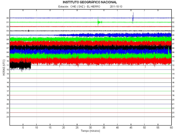
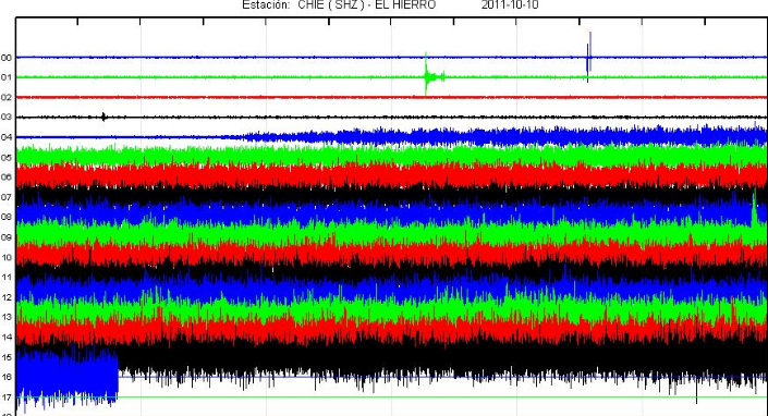
No earthquake in last 10 hours, don't looks good on this graph ....
No releases, pressure grows ..
We cant know how this eruption be strong, I think if don't erupt very soon it be more and more pressure collected for stronger eruption or stronger earthquakes ..
We can learn a lot at similar threads like this one, hope they put alarm for locals there ..
www.ign.es...
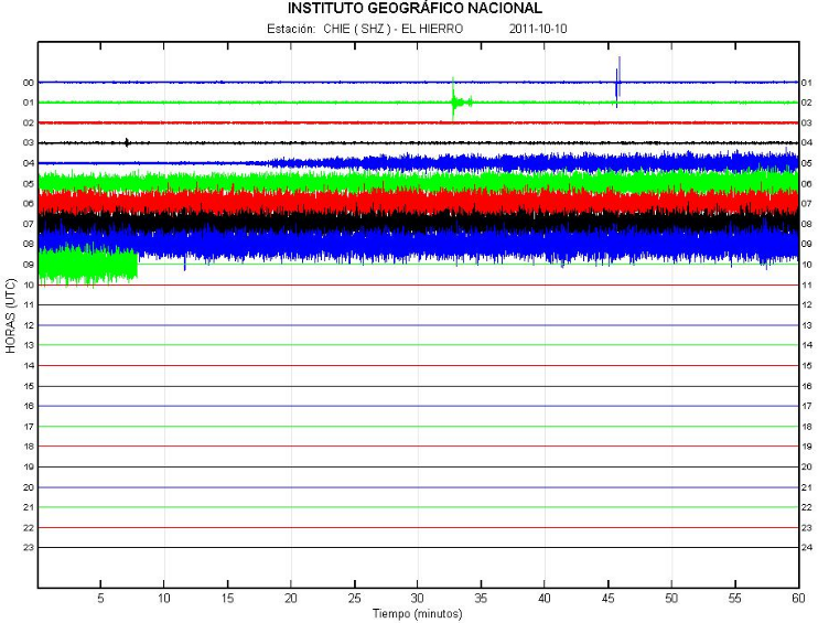
www.01.ign.es...
www.01.ign.es...
earthquake-report.com...
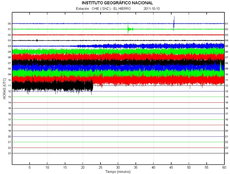
No earthquake in last 10 hours, don't looks good on this graph ....
No releases, pressure grows ..
We cant know how this eruption be strong, I think if don't erupt very soon it be more and more pressure collected for stronger eruption or stronger earthquakes ..
We can learn a lot at similar threads like this one, hope they put alarm for locals there ..
www.ign.es...
www.01.ign.es...
www.01.ign.es...
earthquake-report.com...
edit on 10-10-2011 by Dalke07 because: (no reason given)
Here you can see how it looks in similar graph when Etna erupt, trembling and magma moving up for release ..
thewatchers.adorraeli.com...
www.etnanews.com...
The eruption was somewhat smaller in size than the previous paroxysms. Its main phase lasted from 22h00 to ca. 1 am on 7 August when activity dropped sharply again. The big question is what will come next! Possibly, more paroxsysms (in 2000, a similar series of 66(!) paroxysms occurred from the SE crater), the next one perhaps again in ca. 6 days… Or, a new flank eruption hat finally allows the huge magma storage inside Etna to drain effectively. (VolcanoDiscovery)
thewatchers.adorraeli.com...
www.etnanews.com...
edit on 10-10-2011 by Dalke07 because: (no reason given)
What is its damage scale? Will it go beyond throwing lava at Frontera and disrupting air traffic?
2nd
2nd
Originally posted by flice
What is its damage scale? Will it go beyond throwing lava at Frontera and disrupting air traffic?
2nd
depends on the scale of the eruption.
Some claim tsunamis reaching Florida and east coast.
Check out el hierro simulation vids on u tube.
Originally posted by Sarahko
Originally posted by flice
What is its damage scale? Will it go beyond throwing lava at Frontera and disrupting air traffic?
2nd
depends on the scale of the eruption.
Some claim tsunamis reaching Florida and east coast.
Check out el hierro simulation vids on u tube.
Be warned when looking for said videos. The first three videos that came up for me were all regarding the island of La Palma, not El Hierro, despite the name El Hierro being in the title of the video. I haven't seen any evidence of a "super tsunami" (which many are claiming) forming from an eruption on El Hierro, but a more localised one is always a possiblility if there are any landslides due to the eruption.
reply to post by Dalke07
If I am interpreting the seismo correctly, it looks like there was a quake at 09:58:45 ish UTC. But the background rumble continues. Sure wish I could see what was happening...
Thanks for posting the link to the seismograph.
If I am interpreting the seismo correctly, it looks like there was a quake at 09:58:45 ish UTC. But the background rumble continues. Sure wish I could see what was happening...
Thanks for posting the link to the seismograph.
Originally posted by Olivine
reply to post by Dalke07
If I am interpreting the seismo correctly, it looks like there was a quake at 09:58:45 ish UTC. But the background rumble continues. Sure wish I could see what was happening...
Thanks for posting the link to the seismograph.
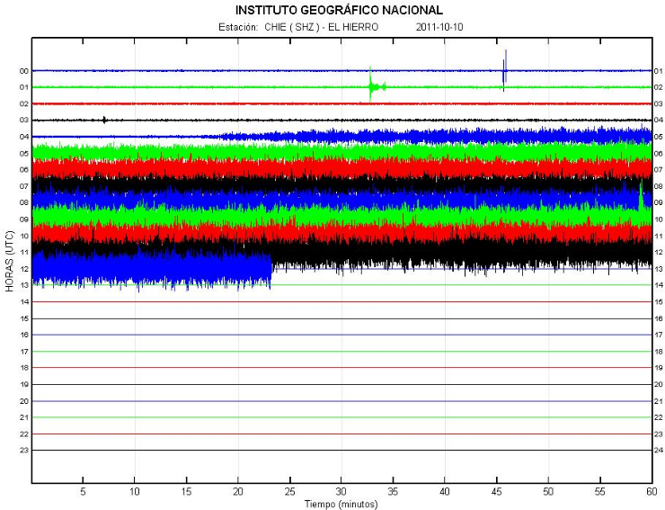
I post before that info updated and I wrote what I see o0nly ..
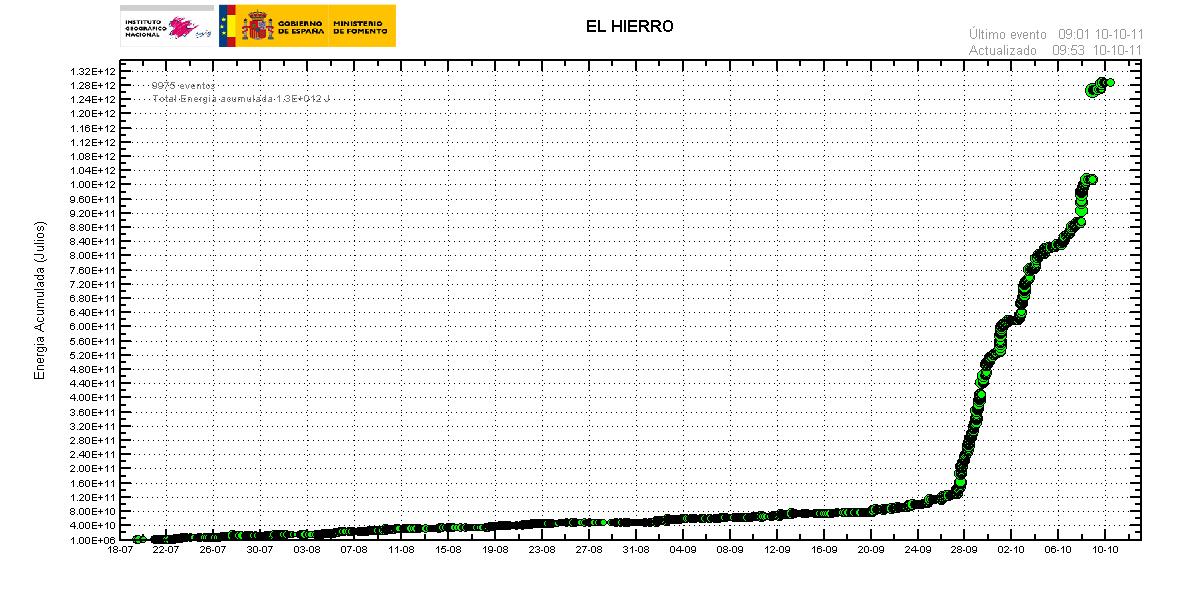
Last one was, 1104142 09/10/2011 23:53:28
Watch eq activities for 07/10/2011 and watch for last 48 hours ..
Is good we have that earthquakes, less pressure ..
www.01.ign.es...
New update ..
edit on 10-10-2011 by Dalke07 because: (no reason given)
Interesting charts, although there still is a possibility that the eruption will only be moderate and the tsunami wave could only reach 1-2 meters.
Or it could be a lot worse. But there's really no way to know till she blows, and the timing is still in debate. Although I admit it does appear somewhat immanent (but how long is that on the geological time-scale?).
So let's wait and see what happens.
People should already have been prepared for this years ago. Disasters always happen, that's why everyone needs a weeks worth of water, a first aid kit, and some canned food, at the bare minimum. Check the ATS Survival forums or Ready.gov for ideas.
edit on 10-10-2011 by muzzleflash
because: (no reason given)
Originally posted by coffeesniffer
reply to post by Dalke07
Are we seeing a harmonic tremor now?
Tremors are increases uniformly ..
I think magma find a way out ..
New update ..
edit on 10-10-2011 by Dalke07 because: (no reason given)
Find some news for underwater eruption, good news ..
www.elmundo.es...
From Spanish to English and put link ..
translate.google.com...
CANARY ISLANDS | detect gases to 600 feet deep
Iron recorded a submarine eruption at 7 kilometers from the coast
New info ..
Iron recorded a submarine eruption at 5 kilometers from the coast
www.elmundo.es...
www.elmundo.es...
From Spanish to English and put link ..
translate.google.com...
CANARY ISLANDS | detect gases to 600 feet deep
Iron recorded a submarine eruption at 7 kilometers from the coast
Seismic observation services have seen a submarine eruption at 1,200 meters deep at sea and seven kilometers from the island of El Hierro.
The phenomenon is ongoing and has occurred at 10.43 (local time) in the sea calms and has been a sudden change in the seismic process, as it has paralyzed for weeks tremors felt in the Canary Islands, as reported by experts to Canary Autonomic Radio.
The Director General of Security and Emergency of the Canary Islands, Juan Manuel Santana, has informed press conference gases were detected at 600 meters below the sea. With these clues, Santana suggests that an eruption will occur, which would be underwater and not cause danger to the public.
New info ..
Iron recorded a submarine eruption at 5 kilometers from the coast
www.elmundo.es...
Seismic observation services have seen a submarine eruption at 1,000 meters deep in the sea and five miles from the island of El Hierro.
The phenomenon is ongoing and began early this morning off the south coast, in La Restinga. The eruption has been a sudden change in the seismic process, as it has paralyzed for weeks tremors felt in the Canary Islands, as reported by experts to Canary Autonomic Radio.
The Director General of Security and Emergency of the Canary Islands, Juan Manuel Santana, has informed press conference gases were detected at 600 meters below the sea. With these clues, Santana suggests that an eruption will occur, which would be underwater and not cause danger to the public.
edit on 10-10-2011 by Dalke07 because: (no reason given)
El Hierro Volcano (Canary Islands) : October 10 : Submarine eruption going on !
earthquake-report.com...
Full report
Good info here to0 ..
Irish whether
IMPORTANT UPDATE 14:13 UTC : The local council of El Hierro has confirmed that a submarine eruption is going on, but stressed that there is NO present danger for the El Hierro population. Following Alpidio Armas, the Cabildo de El Hierro, the eruption occurs at 5 km to the south of La Restinga. Armas also said that the news is “very good” as the accumulated energy will decrease by the present eruption. Armas also said that visitors are invited to visit the island as the island itself is not dangerous … (ER: this is a very optimistic statement)
earthquake-report.com...
IMPORTANT UPDATE 14:31 UTC : PEVOLCA has just published a Press Statement that it is still unsure that an eruption is going on in the Las Calmas Sea. Scientists of IGN which make part of the PEVOLCA committee have stated that IGN has recorded the emission of volcanic gases at the south side of the island. The committee stresses that the gases are NOT dangerous for the population. Additionally IGN reported that the emission might also be an eruptive phase but at the present time there is no 100% proof for it. A certainty however, IGN reported, is that “purely volcanic harmonic tremors” have started. At 7 PM (19:00) local time later today, a new report will be published with the latest results and conclusions of the scientists.
Full report
The address PEVOLCA says there is no certainty of an underwater volcanic eruption on the island of El Hierro. IGN has confirmed early this morning for a small release of fluids and gases from volcanic type that do not involve risk to the public. The National Geographic Institute (IGN), official organ for volcano monitoring has confirmed this morning at the direction of the Civil Protection Plan Volcanic Risk (PEVOLCA), although there is no certainty that it is now producing a volcanic eruption submarine, from early this morning has been a release of fluids and volcanic gases of type on the southern coast of the island IGN scientists have informed the direction of the
Plan that all indicators point to have examined the possibility of the onset of an eruptive process as it has changed the type of wave recorded by seismographs in the last hours, which means the beginning of lava emission or abroad. In this sense, it is purely volcanic signals were not observed until now although it would have to confirm this trend with other parameters such as pressure, gas release or deformation of the ground, among others.
The Helicopter Emergency and Rescue Group of the Canary Islands (GES) has conducted reconnaissance flights in the morning without looking out of volcanic material to the surface. Although this activity does not pose a risk to the population, the Directorate of PEVOLCA recommends that people perform their regular duties normally and remain alert to any unusual activity. At the end of the meeting held this morning in Valverde was determined that this afternoon, starting at 19 hours, the Plan address the latest analysis report scientists conducting IGN.
Good info here to0 ..
Irish whether
edit on 10-10-2011 by Dalke07 because: (no reason given)
is this volcano a super volcano or something? because i all see about it here it's people trying to convince other people that there's no way that
could create a tsunami etc so is not even really that dangerous like yellowstone?
Originally posted by manticorex5
is this volcano a super volcano or something? because i all see about it here it's people trying to convince other people that there's no way that could create a tsunami etc so is not even really that dangerous like yellowstone?
Don't want to speculate to mach, read your self and find info ..
Tenerife is the highest mountain in Spain, and the third largest volcano on Earth on a volcanic ocean island
Canary Islands
Geology The originally volcanic islands –seven major islands, one minor island, and several small islets– were formed by the Canary hotspot. The Canary Islands is the only place in Spain where volcanic eruptions have been recorded during the Modern Era, with some volcanoes still active (even though recently inactive).[26]
Physical geography Tenerife, with 865,070 inhabitants, is both the Canary Islands' and Spain's most populous island. Tenerife is also the largest island of the archipelago. The island of Fuerteventura is the second largest in the archipelago and located 100 km from the African coast. The islands form the Macaronesia ecoregion with the Azores, Cape Verde, Madeira, and the Savage Isles. The archipelago consists of seven large and several smaller islands, all of which are volcanic in origin.[22] The Teide volcano on Tenerife is the highest mountain in Spain, and the third largest volcano on Earth on a volcanic ocean island.
All the islands except La Gomera have been active in the last million years; four of them (Lanzarote, Tenerife, La Palma and El Hierro) have historical records of eruptions since European discovery. The islands rise from Jurassic oceanic crust associated with the opening of the Atlantic. Underwater magmatism commenced during the Cretaceous, and reached the ocean's surface during the Miocene. The islands are considered as a distinct physiographic section of the Atlas Mountains province, which in turn is part of the larger African Alpine System division.
en.wikipedia.org...
El Hierro
Geography, flora and fauna In 2000, El Hierro was designated by UNESCO as a Biosphere Reserve, with 60% of its territory protected to preserve its natural and cultural diversity.[9] Like the rest of the Canary Islands chain, El Hierro is sharply mountainous and volcanic, only one eruption has ever been recorded on the island from the Volcan de Lomo Negro vent in 1793. The eruption lasted a month.
El Hierro is a 278.5 km2 island, formed approx 1.2 million year ago[10] after three successive eruptions, the island emerged from the ocean as a triangle of basaltic dykes topped with a volcanic cone more than 2,000 metres high.[11] With continued activity resulting in the island expanding to have the largest number of volcanoes in the Canaries (over 500 cones, another 300 covered by more recent deposits), together with approximately 70 caves and volcanic galleries, including the Don Justo cave whose collection of channels is over 6km in length.[11]
Landslides have reduced the size and height of the island.[11] The current highest point is situated in the middle of the island, in Malpaso, 1501 meters high. [edit] Landslides and tsunami There is evidence of at least three major landslides that have affected El Hierro in the last few hundred thousand years.[12] The most recent of these was the 'El Golfo' landslide that occurred about 15 thousand years ago, involving collapse of the northern flank of the island.
The landslide formed the El Golfo valley and created a debris avalanche with a volume of 150–180 km3. Turbidite deposits related to this landslide have been recognized in drill cores from the Agadir Basin to the north of the Canary Islands.[13] Detailed analysis of these deposits suggests that the slope failure did not occur as a single event but a series of smaller failures over a period of hours or days. Local tsunami are likely to have been triggered by these landslides but no evidence has been found to confirm this.[12]
en.wikipedia.org...
edit on 10-10-2011 by Dalke07 because: (no reason given)
I'm no expert and you seem to know more than I, at least in the since of acessing graphs and reading them. But, have you checked if this recent lack
of activity has been recorded in the last 2-3 years? Has there been similar times where the pressure has built, but no EQs?
A lot of the time when people report doom as such it turns out to be nothing because they look at such a small window on the timeline.
A lot of the time when people report doom as such it turns out to be nothing because they look at such a small window on the timeline.
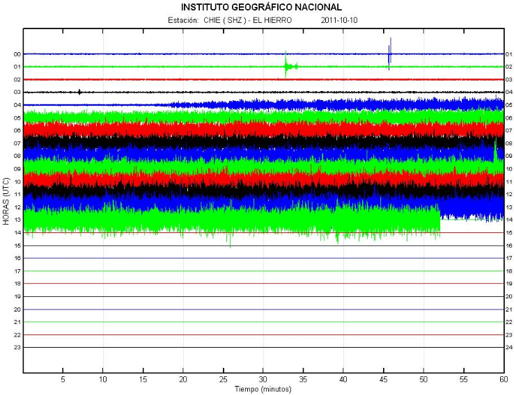
New update ..
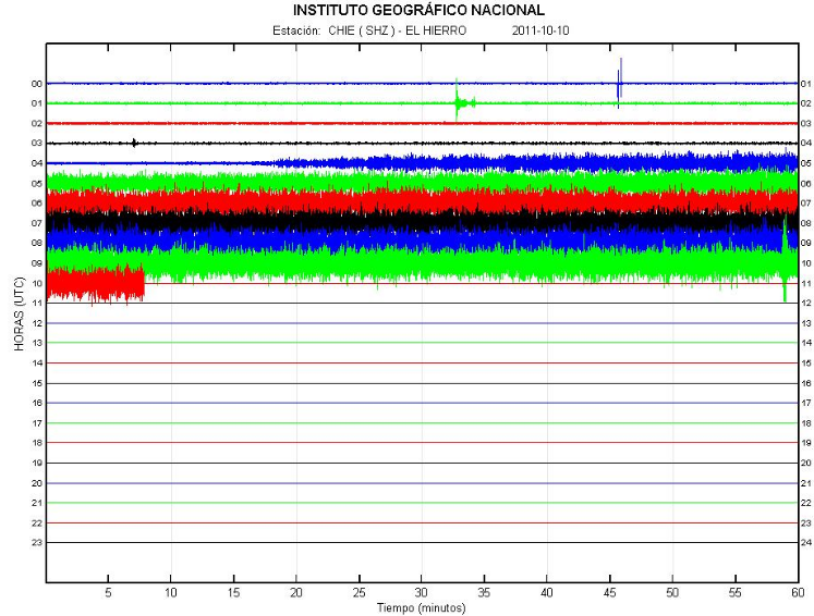
Tremors become stronger with new updates ..
www.01.ign.es...
hisz.rsoe.hu...
Spectrogram
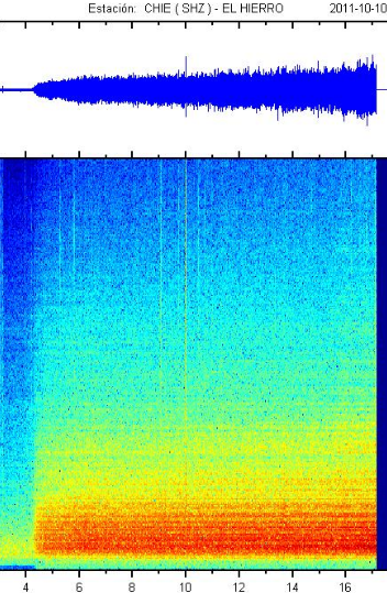
earthquake-report.com...
Tremors become stronger with new updates ..
www.01.ign.es...
hisz.rsoe.hu...
Spectrogram
Update 10/10 – 17:01 UTC : Ramon Ortiz, a vulcanologist specialized in Canary Island volcanoes and currently advising the authorities, says in ElMundo that today’s eruption will be probably at a depth greater than 600 meter below sea level and about 5 km to the southeast of El Hierro. Ortiz also said that the the Harmonic Tremors which started this morning showed that the eruption had started. They were reported in this site only hours after they started (see link and description below). The latest eruption on the Canary Islands took place on La Palma Island in 1971 (see the video below from this eruption).
earthquake-report.com...
edit on 10-10-2011 by Dalke07 because: (no reason given)
I would like to point out that scientists and authorities are using the word "possible" eruption... They do not confirm the eruption yet as they say
they are not sure if it is gas release or lava...
By the way, on Monday morning a quake was registered inland... (a magnitude 2.9).
A meeting has been scheduled for 8 pm... (in about 25 minutes). I am looking forward to the press release of the meeting.
Regards,
Ptolomeo
By the way, on Monday morning a quake was registered inland... (a magnitude 2.9).
A meeting has been scheduled for 8 pm... (in about 25 minutes). I am looking forward to the press release of the meeting.
Regards,
Ptolomeo
edit on 10-10-2011 by Ptolomeo because: to add more info
10/10/2011 16:29 – The El Hierro Council (Cabildo) has stated that the underwater eruption has happened at sea in an area known as ‘La Punta de La
Restinga’ and not in ‘Mar de Las Calmas’ as previously reported.
source www.canariesnews.com...
source www.canariesnews.com...
edit on 10-10-2011 by weatherlovingdude because: (no reason
given)
Originally posted by Dalke07
New update ..
Tremors become stronger with new updates ..
Spectrogram
yep that graph clearly shows an eruption starting at 04:18UTC
as does this graph
www.02.ign.es...
edit on 10-10-2011 by muzzy because: (no
reason given)
new topics
-
CIA is alleged to be operat social media troll frms in Kyiv
ATS Skunk Works: 53 minutes ago -
Rainbow : Stargazer
Music: 1 hours ago -
I sleep no more.
Philosophy and Metaphysics: 4 hours ago -
Canada caught red-handed manipulating live weather data and make it warmer
Fragile Earth: 4 hours ago -
Why Files Our Alien Overlords | How We Secretly Serve The Tall Whites
Aliens and UFOs: 5 hours ago -
Curse of King Tuts Tomb Solved
Ancient & Lost Civilizations: 6 hours ago -
What allies does Trump have in the world?
ATS Skunk Works: 6 hours ago
top topics
-
Canada caught red-handed manipulating live weather data and make it warmer
Fragile Earth: 4 hours ago, 13 flags -
BIDEN Admin Begins Planning For January 2025 Transition to a New President - Today is 4.26.2024.
2024 Elections: 15 hours ago, 10 flags -
Big Storms
Fragile Earth: 17 hours ago, 9 flags -
Why Files Our Alien Overlords | How We Secretly Serve The Tall Whites
Aliens and UFOs: 5 hours ago, 9 flags -
Curse of King Tuts Tomb Solved
Ancient & Lost Civilizations: 6 hours ago, 7 flags -
What allies does Trump have in the world?
ATS Skunk Works: 6 hours ago, 3 flags -
I sleep no more.
Philosophy and Metaphysics: 4 hours ago, 1 flags -
CIA is alleged to be operat social media troll frms in Kyiv
ATS Skunk Works: 53 minutes ago, 1 flags -
Rainbow : Stargazer
Music: 1 hours ago, 0 flags
active topics
-
University of Texas Instantly Shuts Down Anti Israel Protests
Education and Media • 346 • : burritocat -
Supreme Court Oral Arguments 4.25.2024 - Are PRESIDENTS IMMUNE From Later Being Prosecuted.
Above Politics • 104 • : xuenchen -
Canada caught red-handed manipulating live weather data and make it warmer
Fragile Earth • 16 • : ScarletDarkness -
Thousands Call for Netanyahu's Removal Across Israel
Middle East Issues • 121 • : WeMustCare -
CIA is alleged to be operat social media troll frms in Kyiv
ATS Skunk Works • 6 • : pianopraze -
Biden tells Netanyahu immediate ceasefire is 'essential'
Mainstream News • 44 • : WeMustCare -
Why Files Our Alien Overlords | How We Secretly Serve The Tall Whites
Aliens and UFOs • 6 • : Dalamax -
Rainbow : Stargazer
Music • 1 • : network dude -
So this is what Hamas considers 'freedom fighting' ...
War On Terrorism • 275 • : YourFaceAgain -
Big Storms
Fragile Earth • 18 • : bluesman023