It looks like you're using an Ad Blocker.
Please white-list or disable AboveTopSecret.com in your ad-blocking tool.
Thank you.
Some features of ATS will be disabled while you continue to use an ad-blocker.

Canary Islands, El Hierro probably is going to erupt today
page: 4share:
reply to post by warrenite
The speculation was about La Palma, a different island in the Canary Islands.
The speculation has been refuted.
www.abovetopsecret.com...
The speculation was about La Palma, a different island in the Canary Islands.
The speculation has been refuted.
www.abovetopsecret.com...
11/10/2011 20:42 – Joan Martí, a researcher at the CSIC (Instituto de Ciencias de la Tierra) and secretary of the ‘Asociación Internacional de Vulcanología’ (International association of vulcanology) has stated that “As the magma approaches the coast of El Hierro, it could trigger an explosive eruption if it occurs at a depth of less than 200 metres but would not be dangerous if appropriate safety measures are taken”. It is thought that the magma could be following a fault under the sea bed which is known to run underneath the island and could currently be looking for another way to escape to the surface. Scientists have observed that the magma is currently moving towards the centre of the island.
11/10/2011 19:47 – Carmen Lopez from IGN (National Geographic Institute) has said that a new eruption closer to the coast would be ‘more explosive’. The El Roquillo tunnel will remain closed. The president of the Council of El Hierro has said that it is unknown how long the evacuation from La Restinga will last.
11/10/2011 18:49 – The president of the Government is currently meeting with experts and ministers in La Moncloa to discuss the El Hierro situation.
11/10/2011 18:10 – As a precaution, all maritime transport has been prohibited in the danger zone around the epicentre of the eruption off the south coast of El Hierro.
11/10/2011 18:02 – The military arrive at the sports venue where the residents of La Restinga have been evacuated to. The total population of La Restinga has now been evacuated.
www.canariesnews.com...
Live news ..
www.rtvc.es...
edit on 11-10-2011 by Dalke07 because: (no reason given)
reply to post by Phage
Ahh but - Here's some information from John Seach
Here is his full rundown on landslide on El Hierro.
Personally, this whole area puts me completely on edge!
And - This gives me the willies.
It appears to me that a major event is about to unfold.
Ahh but - Here's some information from John Seach
2011 Eruption
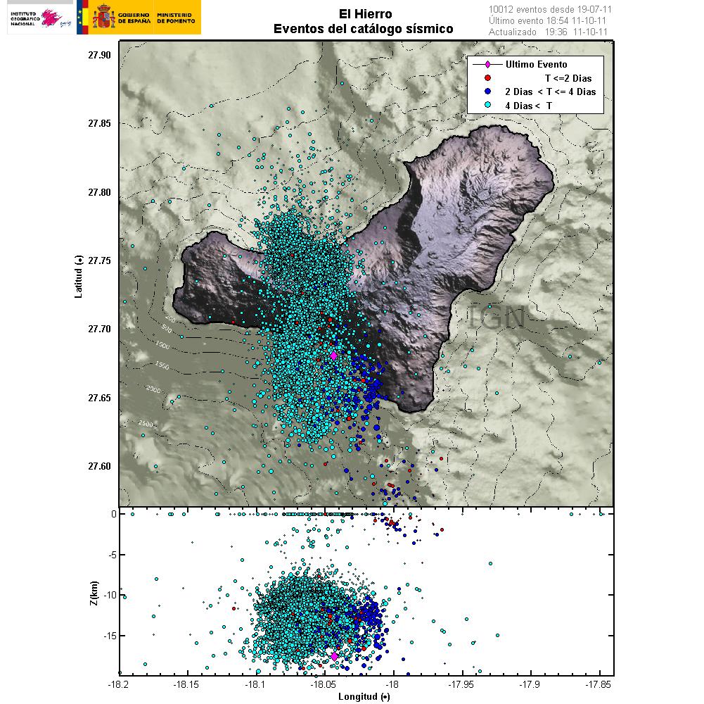
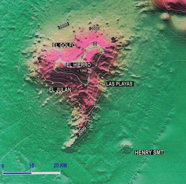
An earthquake swarm occurred at El Hierro volcano in July 2011 with 720 earthquakes measured in a week. The earthquakes were measured between magnitude 1-3, and most were at a depth of 5-15 km. The swarm occurred at El Golfo in the northwest of the island at the location of a landslide that created a 100 metre high tsunami about 50,000 years ago. The earthquakes were continuing at the end of September and some evacuations were ordered for people living near the volcano.
An undersea eruption began off the coast of El Hierro Island, Canary Islands on 10th October 2011. Initial reports placed the eruption site a few kilometres off the south coast of the island at a depth of about 450 m. The eruption was only been confirmed from seismic activity.
Here is his full rundown on landslide on El Hierro.
Personally, this whole area puts me completely on edge!
And - This gives me the willies.
It appears to me that a major event is about to unfold.
Originally posted by Phage
reply to post by intergalactic fire
I would like to see the videos.
BTW, the image on this site: planoinformativo.com... is from the Tonga eruption in 2009.
in-vovo.blogspot.com...
Yes i know that picture is not from Hierro. I only send it because of the article.
Yesterday it was here on the news and there were some videos from the eruption underwater, but can't find it on the internet.
I can't stand this.. I'm so on edge even though I really don't think the catastrophic tsunami will happen.. Living in a place where you can only
get away by going over a few bridges, with 7.5 million other people living here on the island too.. We would pretty much be dead. We are barely 38
feet above sea level here.. I think the highest spot on Long Island is about 350 feet above sea level.. Wonder if we can get up north that far in time
and if it would be safe enough there from a tsunami.
I don't even want to think about it! But everyone on here talking about it like it's definitely going to happen or as if they want it to happen has me very on edge. I have our SHTF bags together, and a few escape plans in case something happens.. But.. it's still so unimaginable to think of..
Just have to try to be as prepared as possible..
There was just another report on the news.
I will try and upload it somewhere if someone is interested.
Only in Spanish of course.
I will try and upload it somewhere if someone is interested.
Only in Spanish of course.
www.youtube.com...
This was the report.
As i now know the video it's showing is not from Hierro.
It was confusing as they don't really tell direct it's an archive video and showing it next to the reporter as she is doing the interview.
My apologies
Red alert is now active in region La Restinga
canariasimporta.blogspot.com...
edit on 11-10-2011 by intergalactic fire because: (no
reason given)
11/10/2011 ALERTA MAXIMA Tremor of great power on the rise since the early hours of yesterday, the possibility of hitting a land eruptive mouth.
Evacuation of La Restinga
www.avcan.org...
www.01.ign.es...
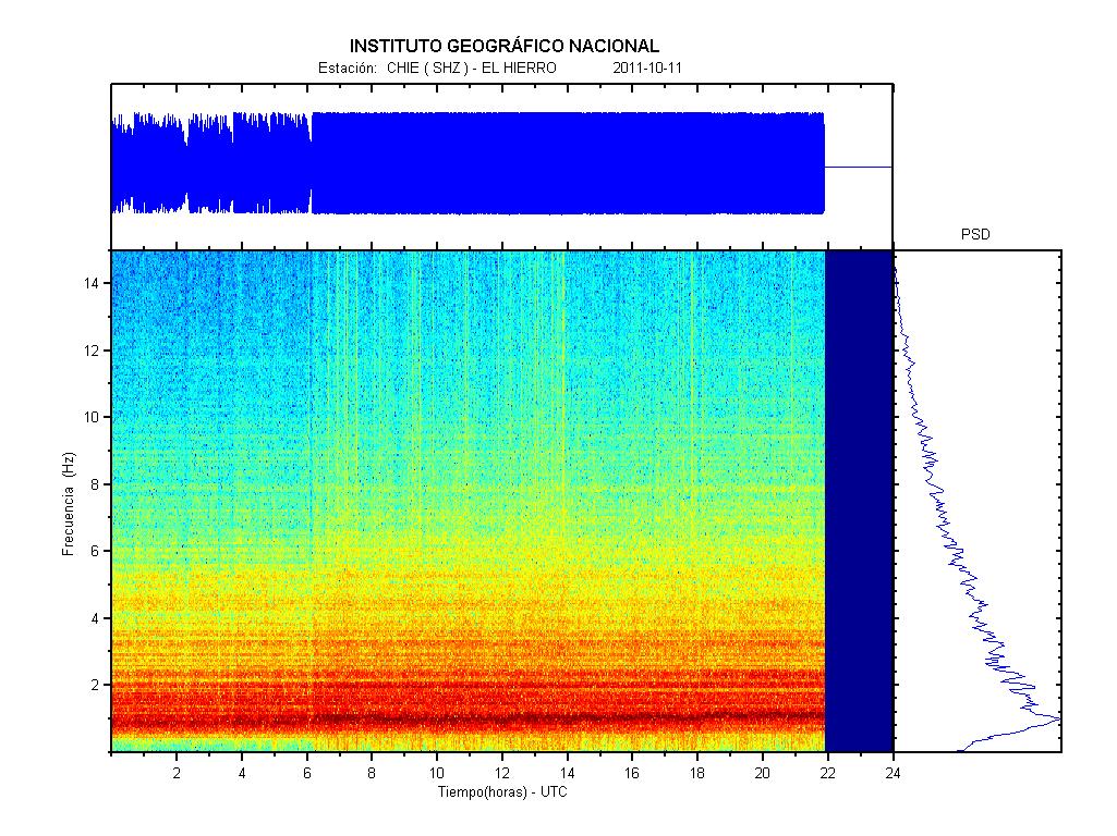
Latest update, spectrogram graph ..
11/10/2011 ALERTA MAXIMA Tremor de gran potencia en aumento desde la madrugada del día anterior, posibilidad de que salga una boca eruptiva en tierra. Evacuación de La Restinga
www.avcan.org...
www.01.ign.es...
Latest update, spectrogram graph ..
edit on 11-10-2011 by Dalke07 because: (no reason given)
El hierro.. Not La palma.. el Hierro...
How likely is that to suffer a landslide, in the event of a huge eruption?
I know the golfo bay was formed due to a landslide... but how sturdy is it now?
Also someone mentioned ''Tremors are being felt on La Palma.''
Can we have some proof of that please?
You're frightening people for no reason whatsoever.
There is now a 'bulge' on the island apparently.
www.standeyo.com...
Rainbows
Jane
'Ballooning' of the island
Officials will meet again in the afternoon with officials from the emergency services for more information about the 'bulge' that has occurred on the island, a parameter that is deemed essential to know the evolution of the process.
www.standeyo.com...
Rainbows
Jane
edit on 11-10-2011 by angelchemuel because: Trying to get external quote right!
edit on 11-10-2011 by angelchemuel
because: (no reason given)
New updated blogg thread by jon Friemann for those of you interested in following events there
www.jonfr.com...
Rainbows
Jane
www.jonfr.com...
Rainbows
Jane
Here a update wat was posted 12 oct even a spanisch video!
thetruthbehindthescenes.wordpress.com...
www.rtve.es...
thetruthbehindthescenes.wordpress.com...
www.rtve.es...
edit on 11-10-2011 by
ni91ck because: (no reason given)
As others on Jon's blog I don't think there has been an eruption but just a degassing at that 5km spot southish of El Hierro.
As for the question where a possible vent is going to open, land or sea, everyone can make his own guess. If anything is going to happen at all, fingers crossed.
As for a VEI 3 or 4, I would immediately sign for it with both hands. But I'm not going to guess or speculate without having some decent information about what's hidden there under El Hierro and surroundings.
reply to post by Nidwin
Couldn't agree more with every word you said!
So much for it 'blowing' as I call it, last night. Mother Nature will 'go' in her own time. I am glad however that they are taking precautions with the people.....if Hierro doesn't 'go' and the seismology shows she is going back to sleep, then so what....it was a good 'exercise' in caution.
Rainbows
Jane
reply to post by Phage
I normally don't challenge or question your posts as they have often proven to be very solid and based on fact. In fact, I've learned quite a
bit in checking things you've said while debunking others.
Every rule has exceptions, however. In this case, I must disagree with your analysis. At least, based on the two links you supplied. I went and looked at them both and on the first one, I'm seeing an academic who has spent most of his life holding jobs that gave a title, but little more. The majority of his time seems to have been spent as a volunteer in a Tsunami advisory group in Hawaii and UNESCO-IOC. Now I won't really get into my feelings about the U.N. or those who spend their careers in those hallowed halls....ahem...but if high respect were among them, I wouldn't have taken the time to reply.
The second site looks quite interesting, but I'm missing where the supporting data and factual basis is for their conclusions..
Now in fairness, we're all talking about a phenomena that no human being has ever witnessed, unless I'm missing something really big in historical records, and I did look for it. There are bits of evidence and hints of what might have been in the DEEP past of our planet, but again..it's supposition and guess work.
Now as noted, we're talking about an event no one has seen, no CLEAR evidence really exists either way as to the hows and whys of previous Mega-Tsunami's that appear to have been catastrophic, but 'appear' is a powerful word in science, as I'm sure you would agree. It carries about 10 shades of doubt and hedge within those 6 little letters. So, at best we seem to have a case where my experts disagree with your experts. I had mentioned I just try and forget this whole chain of Islands even exist. I didn't elaborate exactly why....now I have.
For reference of those who didn't check what I'd posted, here are the top listed sources for the report:
Now, I'm no expert in the world of Academia, but those seem to be solid enough to reference a possible natural event that, if possible, may or may not even occur in our lifetimes or the next millennia for that matter. To say I debunk you or you debunk me on this specific topic, seems a bit of a stretch. Just my feelings...and I stand by what I posted with the source I used to support it. I dare say there are a couple major Universities with a serious credibility issue to address if they have people producing reports out of their departments that are entirely hogwash.
Every rule has exceptions, however. In this case, I must disagree with your analysis. At least, based on the two links you supplied. I went and looked at them both and on the first one, I'm seeing an academic who has spent most of his life holding jobs that gave a title, but little more. The majority of his time seems to have been spent as a volunteer in a Tsunami advisory group in Hawaii and UNESCO-IOC. Now I won't really get into my feelings about the U.N. or those who spend their careers in those hallowed halls....ahem...but if high respect were among them, I wouldn't have taken the time to reply.
The second site looks quite interesting, but I'm missing where the supporting data and factual basis is for their conclusions..
Now in fairness, we're all talking about a phenomena that no human being has ever witnessed, unless I'm missing something really big in historical records, and I did look for it. There are bits of evidence and hints of what might have been in the DEEP past of our planet, but again..it's supposition and guess work.
Now as noted, we're talking about an event no one has seen, no CLEAR evidence really exists either way as to the hows and whys of previous Mega-Tsunami's that appear to have been catastrophic, but 'appear' is a powerful word in science, as I'm sure you would agree. It carries about 10 shades of doubt and hedge within those 6 little letters. So, at best we seem to have a case where my experts disagree with your experts. I had mentioned I just try and forget this whole chain of Islands even exist. I didn't elaborate exactly why....now I have.
For reference of those who didn't check what I'd posted, here are the top listed sources for the report:
Steven N. Ward Institute of Geophysics and Planetary Physics, University of California, Santa Cruz California, USA
Simon Day Benfield Greig Hazard Research Centre, Department of Geological Sciences, University College, London, UK
Now, I'm no expert in the world of Academia, but those seem to be solid enough to reference a possible natural event that, if possible, may or may not even occur in our lifetimes or the next millennia for that matter. To say I debunk you or you debunk me on this specific topic, seems a bit of a stretch. Just my feelings...and I stand by what I posted with the source I used to support it. I dare say there are a couple major Universities with a serious credibility issue to address if they have people producing reports out of their departments that are entirely hogwash.
Hmmmm... well isn't this interesting?
From a Spanish forum, translated using google translate..
I will sit in my wrongness and be wrong now.. if that's okay with you..
Oh and the source:
Source
From a Spanish forum, translated using google translate..
I’ve been puzzling over the GPS data. www.ign.es... Most of the GPS data point to a marked movement of most of Hierro compared with its western end. The GPS shows an accumulated separation of about 35mm between H103 (the western GPS site) and H102 to its east, which are maybe 10km apart. I conclude that the GPS data reflects a big shift of most of Hierro to the North West but the western end of Hierro staying stationary along with H103 on it. Interesting that this zone of maximum motion, between H103 and H102, is above the central focus of the deep EQs so beautifully depicted in GeoLurking’s 3D displays.
I will sit in my wrongness and be wrong now.. if that's okay with you..
Oh and the source:
Source
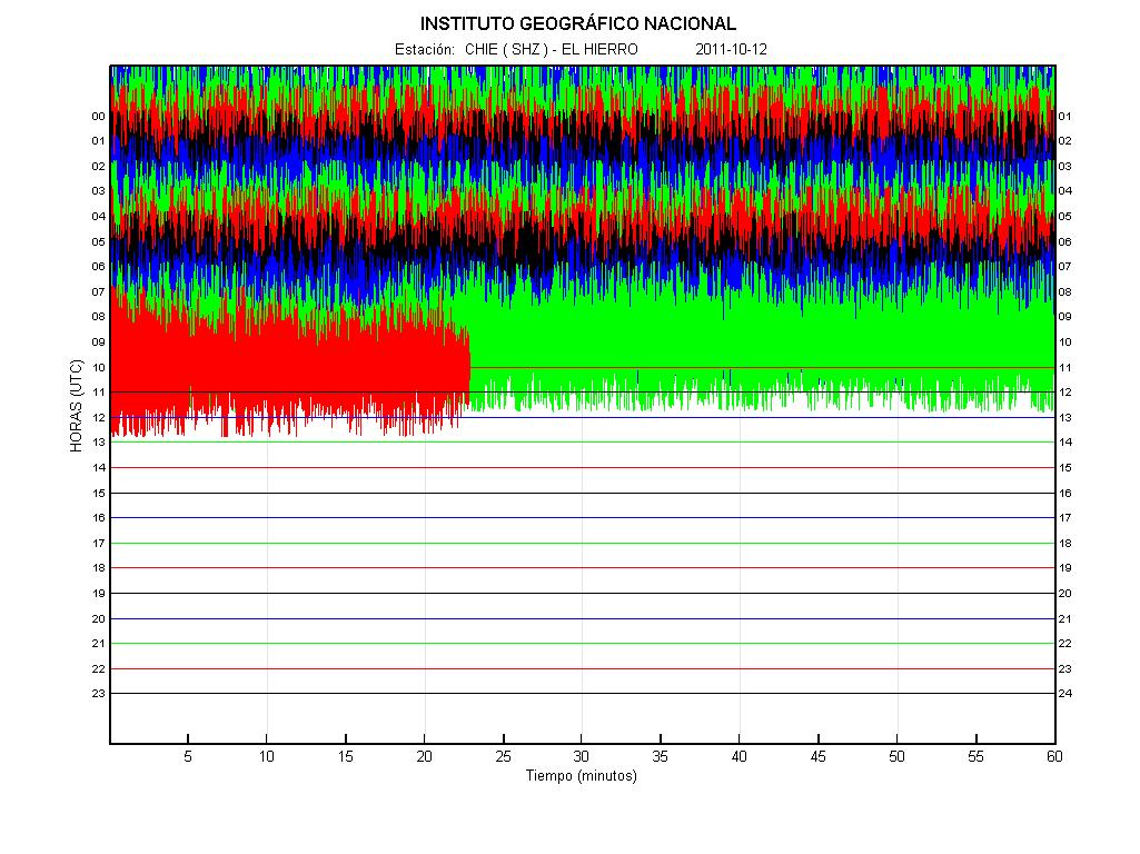
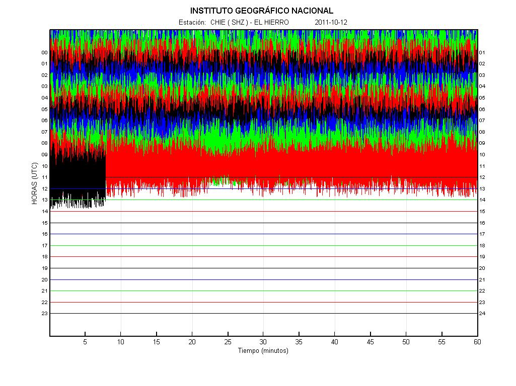
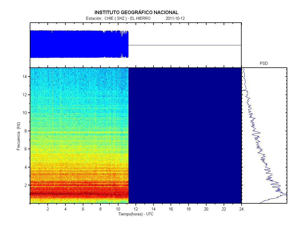
Looks like new update graphs going down ..
Hope this is good news and nothing happened there like no bigger releases of any kind, medium is good thing ..
Hope this is good news and nothing happened there like no bigger releases of any kind, medium is good thing ..
edit on 12-10-2011 by Dalke07 because: (no reason given)
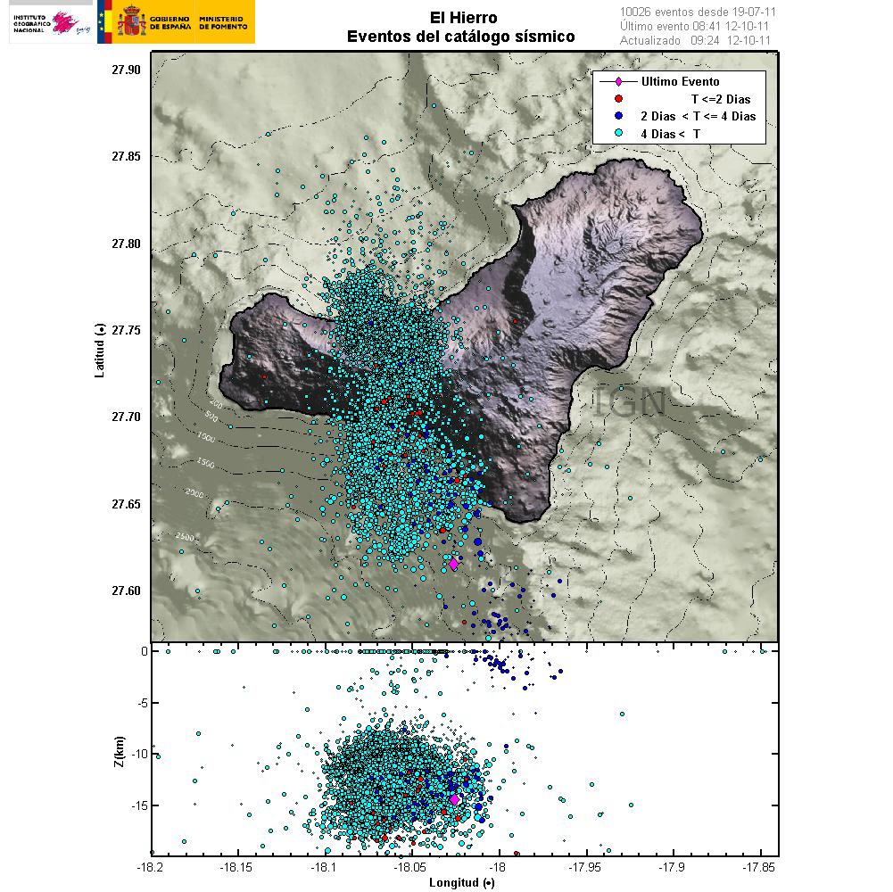
Today earthquakes ..
Last one in similar place where was submarine eruption, hope pressure go far from island and release be in water ..
1104764 12/10/2011 08:41:41 27.6154 -18.0264 14 2.6 mbLg SW EL PINAR.IHI [+]
1104763 12/10/2011 07:06:57 27.6485 -18.0835 18 2.2 mbLg SW EL PINAR.IHI [+]
1104762 12/10/2011 05:04:11 27.5822 -18.0199 10 1.9 mbLg SW EL PINAR.IHI [+]
1104761 12/10/2011 04:55:40 27.7550 -17.9908 20 1.6 mbLg E FRONTERA.IHI [+
1104760 12/10/2011 04:30:51 27.7232 -18.1350 23 1.8 mbLg W FRONTERA.IHI [+]
1104742 12/10/2011 02:33:09 27.7091 -18.0662 18 2.4 mbLg SW FRONTERA.IHI
www.01.ign.es...
11.10.2011
12.10.2011
edit on 12-10-2011 by Dalke07 because: (no reason given)
I am certainly not a geologist or expert but my observations of the data suggest the venting/eruption event is where the energy will more likely be
released and that might be a real good thing. It could deflect the problem away from the island. Still I can see, there could be e-qaukes that affect
the slope. 35 milli-meters seems pretty small unless it does that in just a few hours and continues at a similar pace. I would not get ready to
evacuate from the East Coast unless it was showing more signs than that. The people in charge of these decisions have to use common sense and
carefully think this out or panic sets in. This is an astronomically rare event if it were to occur and would have to be hard to predict. If you live
on the east coast, have a plan whether you think it could happen or not. So if it happens, you can plan now on being as calm as possible to have the
best chance of finding a safe haven.
It is impossible to predict exactly when a vulcano will erupt.
There has been pictures taking of the sea and dead fish in the area of eruption. there was a submarine eruption about 600 metres deep and kilometres away from the coast.
The fish is one that lives very deep at about the same, 500-600 metres deep.
There has been pictures taking of the sea and dead fish in the area of eruption. there was a submarine eruption about 600 metres deep and kilometres away from the coast.
The fish is one that lives very deep at about the same, 500-600 metres deep.
new topics
-
Journalism Against Judaism
Middle East Issues: 2 hours ago -
Bibi’s Dilemma
Middle East Issues: 6 hours ago -
Proof of Cleptocracy
US Political Madness: 10 hours ago
top topics
-
Bibi’s Dilemma
Middle East Issues: 6 hours ago, 10 flags -
Proof of Cleptocracy
US Political Madness: 10 hours ago, 8 flags -
Pfizer agrees to settle over 10,000 Zantac lawsuits after cancer causing substance found in drug
Medical Issues & Conspiracies: 14 hours ago, 7 flags -
Boy Scouts to be renamed next year
Other Current Events: 14 hours ago, 5 flags -
Journalism Against Judaism
Middle East Issues: 2 hours ago, 3 flags
active topics
-
Proof of Cleptocracy
US Political Madness • 12 • : andy06shake -
Boy Scouts to be renamed next year
Other Current Events • 171 • : LSU2018 -
Skinwalker Ranch and the Mystery 1.6GHz Signal
Aliens and UFOs • 163 • : Flyingclaydisk -
Candidate TRUMP Now Has Crazy Judge JUAN MERCHAN After Him - The Stormy Daniels Hush-Money Case.
Political Conspiracies • 1427 • : matafuchs -
Murder Suicide Investigation Still Active 4 months later?
Other Current Events • 2 • : ByeByeAmericanPie -
Journalism Against Judaism
Middle East Issues • 7 • : Mahogani -
New House GOP Bill To Send Pro Hamas College Law Breakers to Gaza for 6 Months
Social Issues and Civil Unrest • 102 • : TheDiscoKing -
Bibi’s Dilemma
Middle East Issues • 18 • : KrustyKrab -
Israeli strikes on southern Gaza city of Rafah kill 22, mostly children, as US advances aid package
Middle East Issues • 201 • : Vermilion -
NYAG Letitia James Prepares to Begin Seizing TRUMP Assets Even Though There Was No Crime.
Above Politics • 291 • : Vermilion