It looks like you're using an Ad Blocker.
Please white-list or disable AboveTopSecret.com in your ad-blocking tool.
Thank you.
Some features of ATS will be disabled while you continue to use an ad-blocker.

Is BP's new cap is on the wrong well?
page: 1share:
First I had a friend send me this video:
After I watched it I did a little research. The Position of the Well Head is 28° 44′ 11.86″ N, 88° 21′ 57.59″ W (28.736628, -88.365997)
Location Source
So I went to www.marinetraffic.com... and took a screen shot.
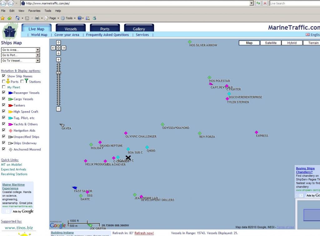
The Black "X" is the approx. location of the well head.
The Discovery Enterprise is nowhere near the well head.
Remember this?
[atsimg]http://files.abovetopsecret.com/images/member/78279d35a4e2.jpg[/atsimg]
The leaning BOP of BPiza?
Live ROV Feeds
Is the new cap on the well head at an angle?
I don't think so.
Why in the heck would BP and the USCG allow the cover up? It would make sense for BP as the EPA fines by the Barrel, But the USCG should tell the truth Right?
I don't have a screen shot of the new cap so if some one would be kind enough to post it or U2U the URL to me include in the OP I would appreciate it.
Any Thoughts?
[edit on 22-7-2010 by SWCCFAN]
After I watched it I did a little research. The Position of the Well Head is 28° 44′ 11.86″ N, 88° 21′ 57.59″ W (28.736628, -88.365997)
Location Source
So I went to www.marinetraffic.com... and took a screen shot.
The Black "X" is the approx. location of the well head.
The Discovery Enterprise is nowhere near the well head.
Remember this?
[atsimg]http://files.abovetopsecret.com/images/member/78279d35a4e2.jpg[/atsimg]
The leaning BOP of BPiza?
Live ROV Feeds
Is the new cap on the well head at an angle?
I don't think so.
Why in the heck would BP and the USCG allow the cover up? It would make sense for BP as the EPA fines by the Barrel, But the USCG should tell the truth Right?
I don't have a screen shot of the new cap so if some one would be kind enough to post it or U2U the URL to me include in the OP I would appreciate it.
Any Thoughts?
[edit on 22-7-2010 by SWCCFAN]
My thought: Not surprised. There's a TON of evidence now that the whole crisis resolution of this horror is a sham. The GOM and it's residents
continue to be in grave danger.
BP are notorious liars. When BP speak, one can be certain that they are not telling the whole truth.
If they capped the wrong well, it would be because the Deepwater could not be capped not because they are idiots.
If they capped the wrong well, it would be because the Deepwater could not be capped not because they are idiots.
Not sure if you've seen it but in the top left of the display is the Lat/Lon of the ROV. Compare with the position of the well.
You might need a different frame - it is hard to see the latitude in the still capture you have.
[edit on 22-7-2010 by mirageofdeceit]
You might need a different frame - it is hard to see the latitude in the still capture you have.
[edit on 22-7-2010 by mirageofdeceit]
reply to post by mirageofdeceit
yeah i saw it looking online for a conversion formula to convert it WGS 84
I remeber watching the new cap being put on the wellhead but it was not leaning.
yeah i saw it looking online for a conversion formula to convert it WGS 84
I remeber watching the new cap being put on the wellhead but it was not leaning.
The location of enterprise, which is indeed no where near the Deepwater Horizon is approx, in lat and lon: 28.7456N by 088.3482W. Right clicking the
map and viewing the image enlarges it. The lat and lon for Deepwater (according to the X) is 28.7360N by 088.3665W.
So if nothing is leaking there, then why has there been a cap in the water all this time. Mind you this is the type of cap, or similar, that they had on Deepwater that was sucking oil to the tankers. This is NOT the cap that is currently on Deepwater.
EDIT: Did a bit more research: The Enterprise vessel is approximately 1.2 nautical miles from Skandi:
Now the question we must ask and research is: what well is near that location? If it is of any interest, I do not have a screen shot though, Viking Poseidon was surveying a well about a week or so ago. The well head said 'Kepler'. Here is a link about it:
Na Kika Oil and Gas Fields, Gulf of Mexico, USA. The Na Kika field extends over Missisipi Canyon blocks 474, 429, 657, 607, 522, 520, 383 in the Gulf of Mexico, approximately 140 miles south-east of New Orleans, Louisiana, US. It has recoverable reserves of 300 million barrels of oil equivalent and a production rate of around 110,000bpd oil and 500 million cubic feet of gas a day.
It originally consisted of five independent oil and gas fields – Kepler, Ariel, Fourier, Herschel and E Anstey..
We need to see what the location of this well is in lon and lat. If its the one I am thinking, then this is the one that MIGHT be leaking.
[edit on 22-7-2010 by DragonFire1024]
Ive said it in 2 threads before, I'll say it again.
The day I watched them fitting the DWH cap I said to my girlfriend that it did not look like the same well. The flow of oil coming out of the well they were capping was considerably weaker & consisted of considerably less gas bubbles than all the video of the leak we had been seeing for so long.
I have faith someone here will be able to prove the coordinates are different, however for now we can add some credit to the 'theory' we were shown a different well being capped by examination of video from, eg, a week before the capping, & the video of the capping process.
Hopefully someone out there has the skills to calculate the flow rates in both videos, & there is a lot of video from the pre-capped well.
From my inexperienced eye, I noticed a significant difference in the flow coming from the well, did anyone else notice this or was it just me ?? Maybe we are seeing something different here in Aus.
reply to post by SNAFU38
Its not the same well the BOP was clearly leaning on the well with the first cap. I am sure a fellow ATS has the Screenshots to prove this.
Its not the same well the BOP was clearly leaning on the well with the first cap. I am sure a fellow ATS has the Screenshots to prove this.
reply to post by SWCCFAN
Literally just got this screen shot of the Deepwater well cap. BOA DEEP C 2 was just showing it. Its not the best shot, but I think you can work with it:
Also Here is a screen shot of the "sucker" as I call it (this is the type of thing that was sucking oil to tankers from the Deepwater well BEFORE it was capped. This is from Enterprise just moments ago: Keep in mind, Enterprise is 1.2 nautical miles from Skandi. I will try to get a better shot with the serial numbers or ID numbers.
Also...the Enterprise is approx. 114 Nautical Miles from the Port of New Orleans. The Kepler well, according to the post I did above, is approx 140 miles from New Orleans..so I think we are making progress
[edit on 22-7-2010 by DragonFire1024]
I just read that they are currently capping the to relief wells due to "Bonnie" coming.... Although I think OP might be on to something!
Position of Wel Head in every normal measurement:
Degree, Minute, Second:
Latitude: 28° 44' 11.861" N
Longitude: 88° 21' 57.589" W
Degree Decimal:
Latitude: 28.736628
Longitude: -88.365997
Universal Transverse Mercator (UTM):
Zone: 16
Easting: 366609
Northing: 3179571
Minute, Decimal:
Latitude: 28°44.19768
Longitude: -88°21.9598199999996
[atsimg]http://files.abovetopsecret.com/images/member/78279d35a4e2.jpg[/atsimg]
None of those numbers come close to the numbers in the screenshot.
So anyone have any Idea if their is a location method I missed cause the numbers are not adding up.
reply to post by bair1975
Yeah I Knew that was coming but all the vessels even now are still "on Station" none are presently making way.
I don't know what to make out of the Data I am by far an expert on this sorta thing but from what I see somthing is not right.
Yeah I Knew that was coming but all the vessels even now are still "on Station" none are presently making way.
I don't know what to make out of the Data I am by far an expert on this sorta thing but from what I see somthing is not right.
The ships are moving for the storm approaching. So it's important to note what time those ship position fixes were taken. With all the screen
captures, I'm sure you can get positions of the ROVs at many different times. But, if they were trying to fool us, would they give us the real
locations?
Just wondering, does TH on what you call the sucker maybe stand for Top Hat?
[edit on 22-7-2010 by ttatw]
Just wondering, does TH on what you call the sucker maybe stand for Top Hat?
[edit on 22-7-2010 by ttatw]
reply to post by SWCCFAN
The UTM coordinates are close to that of the Q4000's: The Q4000 31: UTM: E 366650.23 N 3179561.49
The UTM coordinates are close to that of the Q4000's: The Q4000 31: UTM: E 366650.23 N 3179561.49
Originally posted by ttatw
The ships are moving for the storm approaching. So it's important to note what time those ship position fixes were taken. With all the screen captures, I'm sure you can get positions of the ROVs at many different times. But, if they were trying to fool us, would they give us the real locations?
Just wondering, does TH on what you call the sucker maybe stand for Top Hat?
[edit on 22-7-2010 by ttatw]
The Enterprise, according to that website on the OPs post, is Anchored...so it has not moved. especially not with an ROV still in the water. Skandi is also anchored.
reply to post by ttatw
The ship's position as of 2135 CST is the same as thew were when I took the screenshot in the OP.
I am aware of them moving for the storm. As soon as I get off work I have to start packing my whole house up like I am moving. Because if we have oil innundate the low lying areas I will not be allowed back home until it is cleaned up.
BP will be getting a Claim from me as of tomorrow.
If it were not for the spill I would not be evacuating.
Thanks BP
BP: Beyond Problematic
reply to post by SWCCFAN
What I meant was the two relief wells they are digging look relatively the same as the deepwater horizon, and they are CAPPING them as we speak so they can disconnect and head in. They had to pull most the casings and as they put it " cement the cap in"?
What I meant was the two relief wells they are digging look relatively the same as the deepwater horizon, and they are CAPPING them as we speak so they can disconnect and head in. They had to pull most the casings and as they put it " cement the cap in"?
This thread is a perfect example of why I joined ATS in the first place.
Some reported today on ATS' Live Feed thread that they saw a cap being lifted to the top.
With the storm on the way and all the lies they have told us so far, not much telling what they are doing. I would assume feeds may be discontined soon due to Tropical Storm Bonnie.
With the storm on the way and all the lies they have told us so far, not much telling what they are doing. I would assume feeds may be discontined soon due to Tropical Storm Bonnie.
reply to post by bair1975
Yeah but those 2 rigs can ride out the storm and you would not even notice it on the rig unless you went outside and saw the wind and rain.
According to The Weather Channel they just said they will be leaving the Cap on the well.
Is the truth out there?
Everything associated with this well seems to be lies.
new topics
-
Hamas and Other Islamist Terrorist Groups Announce Support of US Campus Anti-Israel Protests
Education and Media: 25 minutes ago -
Psychotronic Operation Rwanda Who Wants To Be A Refugee?
ATS Skunk Works: 52 minutes ago -
AI phrenology
Science & Technology: 7 hours ago
top topics
-
4/27/24 New Jersey Earthquake
Fragile Earth: 13 hours ago, 8 flags -
CIA is alleged to be operat social media troll frms in Kyiv
ATS Skunk Works: 16 hours ago, 6 flags -
AI phrenology
Science & Technology: 7 hours ago, 4 flags -
Fun with extreme paints
Interesting Websites: 15 hours ago, 2 flags -
Psychotronic Operation Rwanda Who Wants To Be A Refugee?
ATS Skunk Works: 52 minutes ago, 2 flags -
Rainbow : Stargazer
Music: 16 hours ago, 1 flags -
Hamas and Other Islamist Terrorist Groups Announce Support of US Campus Anti-Israel Protests
Education and Media: 25 minutes ago, 1 flags
active topics
-
Hamas and Other Islamist Terrorist Groups Announce Support of US Campus Anti-Israel Protests
Education and Media • 1 • : FlyersFan -
Why Files Our Alien Overlords | How We Secretly Serve The Tall Whites
Aliens and UFOs • 17 • : ChaoticOrder -
Supreme Court Oral Arguments 4.25.2024 - Are PRESIDENTS IMMUNE From Later Being Prosecuted.
Above Politics • 123 • : xuenchen -
Biden Banning Menthol Cigarettes - Good Health Move or Government Overreach?
US Political Madness • 92 • : FlyersFan -
Psychotronic Operation Rwanda Who Wants To Be A Refugee?
ATS Skunk Works • 1 • : TimBurr -
So this is what Hamas considers 'freedom fighting' ...
War On Terrorism • 278 • : FlyersFan -
Killings of Palestinian children are soaring in the West Bank.
World War Three • 162 • : FlyersFan -
Ireland VS Globalists
Social Issues and Civil Unrest • 16 • : TimBurr -
University of Texas Instantly Shuts Down Anti Israel Protests
Education and Media • 383 • : FlyersFan -
4/27/24 New Jersey Earthquake
Fragile Earth • 6 • : soulrevival